|
1.Basic Theory |
The water that flows through the rivers is merely part of a greater cycle that is occurring all around us each day, the Hydrologic or Water Cycle.
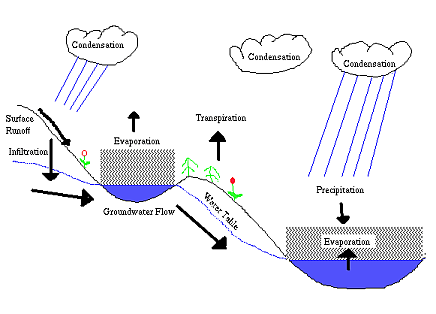
Precipitation can take many forms from rain to snow to hail to sleet. Though different, each form of precipitation has one thing in common and that is that they each fall from clouds in the sky to the ground. When water hits the ground, it can go in two directions, vertical or horizontal. The vertical flow is called infiltration. The horizontal flow is called surface runoff.
Infiltration happens when the precipitation filters into the ground and travels all the way down to the water table. The water table is the top layer of saturated ground that can be found across the planet. In places where the water table is above the surface, water fills these places until the water level is the same as the water table level, thereby forming rivers and lakes. The water found in the water table is called groundwater. If there has not been any rainfall in several days, the rivers will keep falling until the river levels are the same height as the water table.
Surface runoff is when precipitation moves along the surface of the ground when either the ground can no longer absorb the water, or the ground cannot absorb the water fast enough. The water flows (via gravity) along the surface until it finds its way into a stream, river, lake, or ocean. Surface runoff causes the stream to rise quickly after it rains because it is the fastest way water can reach a river or stream, much faster than through infiltration.
To be able to forecast the amount of water flowing through a certain point along a river, the forecaster breaks the flow down into three components:
Baseflow
Baseflow, the water coming from groundwater, is never a constant value. It increases immediately after rainfall, and then it falls until the next rainfall.
Runoff
Runoff comes from two sources, rainfall and snowmelt. A forecaster can estimate the amount of runoff for each type based on certain characteristics of the weather and the river basin. Snowmelt calculations are based on the air temperature and the amount of sunshine. Rainfall runoff is estimated based on the slope of the land, the amount of urbanization, the soil types, the amount of the last rainfall, the time since the last rainfall, and the amount of evaporation occurring over the basin.
When rain begins to fall, the runoff does not immediately go into the river. It takes time for the runoff to flow into the river and the amount of time depends on where in the basin the rain fell. To get a sense of how this works, envision a parking lot with a storm drain at one end. Next, think what happens if a steady, even rain fell over the entire parking lot. All of the rain wouldn't reach the drain at once, because the distance the rain needs to travel to the drain varies throughout the parking lot. Even when the rain stops, water will continue to flow into the drain until the water from the far part of the parking lot reaches the drain. If the amount of water going through that drain was recorded and put on a graph of water flow versus time, it would look something like this:
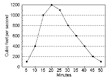
Any graph of water flow versus time is called a hydrograph. When a forecast is being made, the forecaster always uses a hydrograph of the stream at the forecast point. From this hydrograph, the forecaster can begin to make a forecast.
A special hydrograph, called the unit hydrograph, is used by forecasters when they want to know how much water will be put into the stream by runoff. The unit hydrograph is based on the basin receiving enough rain to make one inch of runoff. An inch of runoff is the equivalent to having the entire basin of a particular stream or river covered in an inch of rain that does not infiltrate into the ground. The unit hydrograph shows how much of this inch of runoff will go into the stream in a specific amount of time. Also, for the unit hydrograph to work properly, the length of time in which the runoff was generated and the time intervals on the unit hydrograph must be the same and the rain that produces the runoff must fall within the first X hours of the X hour unit hydrograph. At the ABRFC, we use a six-hour unit hydrograph for most river forecast locations. A six-hour unit hydrograph describes how much water is flowing into the stream from runoff in six hour periods. Remember, the rain that produces the runoff must fall in the first six hour period. As you can see below, from 0 to 6 hours, 800 cubic feet per second (cfs) of runoff water has been added to the stream.
| Time | 0 | 6 | 12 | 18 | 24 | 30 | 36 | 42 | 48 | 54 | 60 |
| Flow | 0 | 800 | 2500 | 4300 | 5700 | 6500 | 6000 | 5100 | 4200 | 3400 | 2900 |
If, for instance, the runoff is something other than one inch, 0.1 inches for example, then multiply the unit hydrograph value by the amount of runoff to find the amount of flow into the stream. In the above example of 0-6 hours, 800 cfs is added for each inch of runoff. So, if only 0.1 inches of runoff is to be added, then multiply the runoff by the hydrograph value. So in this example, at the end of six hours, 0.1 * 800 = 80 cfs of water flow has been added to the stream.
Now, consider what would happen if we want to forecast for 24 hours. We notice that 1 inch of runoff there will give us 5700 cfs. By our example above, if the runoff amount is 0.1 inches, then we find that the amount of water flowing into the stream is 0.1 * 5700 = 570 cfs. Now what would happen if another 0.1 inches of runoff was generated by rainfall 6 hours later. Then we would look at the 18 hour hydrograph value because you are basically looking at the amount flowing in the stream for 24 hours, but the rain did not start until after the first six hours. For 18 hours the flow amount for one inch of runoff is 4300 cfs. For 0.1 inches of runoff, the amount added to the stream flow would be 0.1 * 4300 = 430 cfs. Now the forecaster adds the amounts of the initial 0.1 inches of runoff for the 24 hour forecast and the amount for the 0.1 inches of runoff that occurred six hours later (570 cfs + 430 cfs = 1000 cfs) to get 1000 cfs to be added to the stream flow 24 hours in the future.
Upstream Flow Routing
The final component of streamflow is the routed flow, the water that is coming downstream from the previous gage point. Many different methods of routing are used, but they all rely on the same principle: all of the water that passed through the upstream point must eventually pass through the downstream point, barring human intervention. But due to various factors, such as the riverbed slope, the viscosity of water, distance between gaging points, the peak flow at the downstream location is never more than the upstream location. In most cases, the peak flow at the downstream location is lesser.
A river forecast model computes and sums each of the three flow components mentioned above for every forecast period, and converts the total flow to a stage forecast. Six different rainfall-runoff models and three routing methods are widely used by NWS River Forecast Centers.
The ABRFC uses the Sacramento Soil Moisture Accounting rainfall-runoff model. The Sacramento Model (developed at the California Nevada RFC in Sacramento, CA) is a conceptual model that determines total runoff based on the the interaction of two soil zones. An array of variable parameters are used to simulate the movement of water into and out of these zones. The model stores soil moisture conditions to effectively estimate the amount of runoff a future rain event will generate.
To determine downstream routing, the ABRFC uses the Lag/K method. In its simplest form, Lag/K is a two variable routing method. The first variable, lag, represents how long the water takes to get from one forecast point to the next. The K variable indicates the amount of attenuation occurring, or how the wave of water spreads out as it flows downstream.
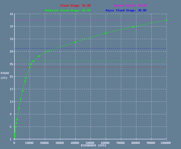
Local runoff from the Sacramento model is run through a Unit Hydrograph operation to determine local flow. The local flow is added to routed flows for each upstream site to determine the total flow for each forecast period. Total flow is converted to a stage forecast using a rating curve. Rating curves, like the one below, show the relation between stage and flow at a gage site. Most of the ABRFC's forecast points coincide with Army Corps of Engineers (link to Tulsa District gages) or USGS gaging stations. Both of these organizations take frequent streamflow measurements (the green dots on the green line) to keep the rating curves up-to-date.
The Output
ABRFC forecasters combine model guidance, local knowledge and hydrologic expertise to create the most accurate forecasts available. After examining and modifying the model output, the forecaster runs a computer program that automatically prepares and formats the forecast for dissemination. The ABRFC passes these forecasts along to the National Weather Service Weather Forecast Office that has hydrologic responsibility for that area. This Weather Forecast Office is then responsible for issuing public statements regarding that particular section of river.
River Stages
River stages are our most important type of data. River stage data is collected in one of three ways:
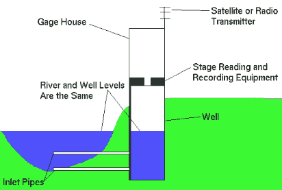
1. Gage Houses
Gage houses are the most common sources of river stage data.
A gage house consists of a well dug along the riverbank with an instrument house above it. Water enters the well through one or more inlet pipes. The water in the well will be at the same level as the river, so the recording equipment above it actually records the water level in the well. This data can be either saved at the gage site and can be transmitted via satellite or radio.
2. Wire Weight Gage
This type of gage is usually mounted to the side of a bridge. It consists of a spool of wire, with a weight attached to the end of the wire. The river level is measured by lowering the weight until it touches the river surface. The distance between the bridge and the water is measured, which is then subtracted from the distance from the bridge to the riverbed. The resulting number is the river stage.
3. Staff Gage
The third type of gage is by far the simplest. A staff gage is basically a ruler attached to the river bank, a bridge piling or anything next to the river. The river level is measured by reading the markings on the gage.
Precipitation
Rainfall amounts are also necessary for river forecasting, since, without rainfall data, one cannot predict runoff, and therefore, future stages.
1. Weighing Gage
This type of gage consists of an antifreeze-filled collection bucket mounted on top of a scale. As rain, snow, hail, or any type of precipitation falls into the collecting bucket, the bucket becomes heavier. The antifreeze is there to allow the liquid content for frozen precipitation to be measured. Every few minutes, a recorder attached to the scale records the weight of the bucket contents. Since the size of the bucket, the weight of antifreeze, and the density of water are known, a precipitation amount can be measured from the weight of the bucket.
2. Tipping Bucket
A tipping bucket rain gage consists of a funnel and a rocker mechanism with two little "buckets" on it, located underneath the funnel. When rain falls into the funnel, it fills one of the little buckets on the rocker mechanism. Once a given amount of rain falls into the funnel, usually 0.01 inches, the rocker "tips" over, emptying one of the buckets and moving the other one underneath the funnel. A recorder in the gage records each tip and the time it occurred. The tipping bucket gage has its disadvantages, however. It cannot be used in freezing weather because the mechanism or the funnel hole can freeze solid. Sometimes the tipper mechanism doesn't work or double tips.
3. Standard Rain Gage
A standard rain gage consists of only three parts - a funnel, a can, and a measuring tube. Rain falls into the funnel and into the measuring tube. Having the funnel wider than the measuring tube increases the depth of water in the measuring tube, and allows rainfall to be measured to the nearest 0.01 inch. When frozen precipitation is expected, the funnel and measuring tube are removed, and the precipitation is collected in the can. To measure the liquid equivalent of the frozen precipitation, the contents of the can are melted and poured back into the measuring tube for measurement.
4. Doppler Radar
One of the functions of the NWS doppler radars is to estimate rainfall amounts based on the intensity of the radar echoes. This data is then combined with rain gage data to give a best guess of rainfall estimation for a region.
Click here for a more in-depth discussion on precipitation measurements and their relationship to hydrologic modeling, or here for ABRFC's precipitation processing methodology.
Temperature and Sunshine Data
Temperature and sunshine data are useful with both snowmelt and evaporation estimations used in river models. Hourly temperature data comes from official NWS observing sites, usually at airports. Some of these airports also report total minutes of sunshine observed in the previous day. Volunteer NWS cooperative observers also report the previous day's maximum and minimum temperature.
River forecasting has many benefits to the public:
Flood and High Water Forecasting
This is our most important and highest profile duty. Millions of dollars and countless lives are saved each year from timely and accurate predictions of both flood crests and flood duration.Industry and Utilities
Industries dependent upon a river for water also rely on river stage forecasts. Besides the obvious need for flood forecasts, some riverside industries are required to adjust their operations, such as water intake, based on the river levels. Utilities, such as water and sewage treatment plants, can also have their operations affected by river and stream levels.Dam Operations
Dam operators need to know how much water is coming into the reservoir to properly maintain the water level.Recreation
Many types of aquatic recreation can be affected by river and stream levels. Boaters will not be able to use a river if the water is too high or too low. Anglers will change their techniques or catch based on stream levels. Also, many state parks are built on watershed areas of dams and reservoirs. Knowing how reservoir levels are going to be affected by rainfall is important to park operators.
History of National Weather Service River Forecasting
The National Weather Service's River and Flood Program traces its origins back to the start of the National Weather Service itself. In 1870, Congress authorized the Army Signal Service Corps to create a river and stream gauge program, as well as a weather observation and forecasting program. Then, Congress passed the Organic Act of 1890, that transferred all weather and related river services into the Department of Agriculture, and created a civilian U.S. Weather Bureau, which would later become the National Weather Service (NWS).
As the country grew, the need for expanded hydrologic services grew with it. In 1903, an extensive and disastrous flood struck the Kansas River, further raising public cries for improved flood forecasting. In response, Congress passed legislation making river and flood services a separate division within the Weather Bureau. Starting with the Kansas River, expanded hydrologic services moved into Texas and then throughout the entire country within the next few years.
With the nation's continued growth, the economy became increasingly dependent on river and flood forecasting, but the emphasis still remained on protection of life and property. In 1940, the Weather Bureau was transferred into its present home, the Department of Commerce, and a river division, now known as the NWS Office of Water Prediction, was formed. This river division divided the country into river districts, each with an associated Weather Bureau office to cater to the hydrologic needs of that area. By the end of World War II, the increasing responsibilities of the regular Weather Bureau offices prompted the need for separate River District Offices. Finally, through the 1960's these offices combined into the 13 River Forecast Centers that exist today.