
Dangerous heat will expand from the Gulf Coast into the Southern Plains and Desert Southwest through week's end. Additional extreme heat impacting the Pacific Northwest will shift to the northern Plains by the weekend. Tropical Storm Bertha is expected to continue to impact portions of the northern Gulf Coast from the western Florida Panhandle to southeastern Louisiana through tonight. Read More >
|
The Panhandles' Only F5: by Justyn Jackson, Brady Kendrick, and Trent Spencer |
||||
|
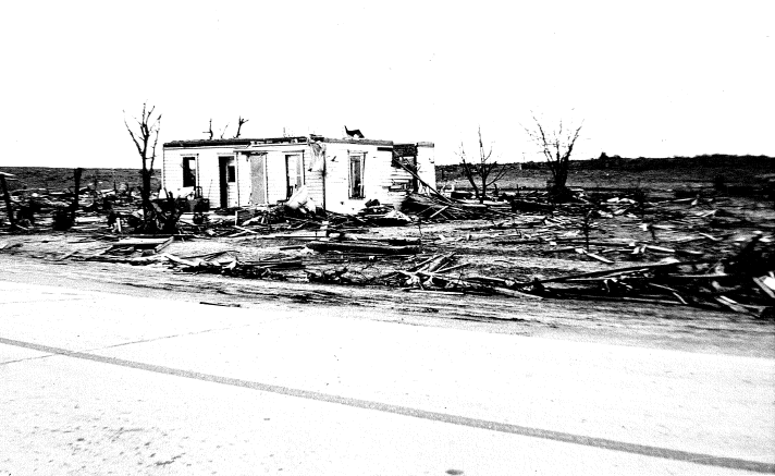
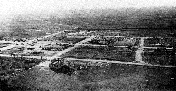
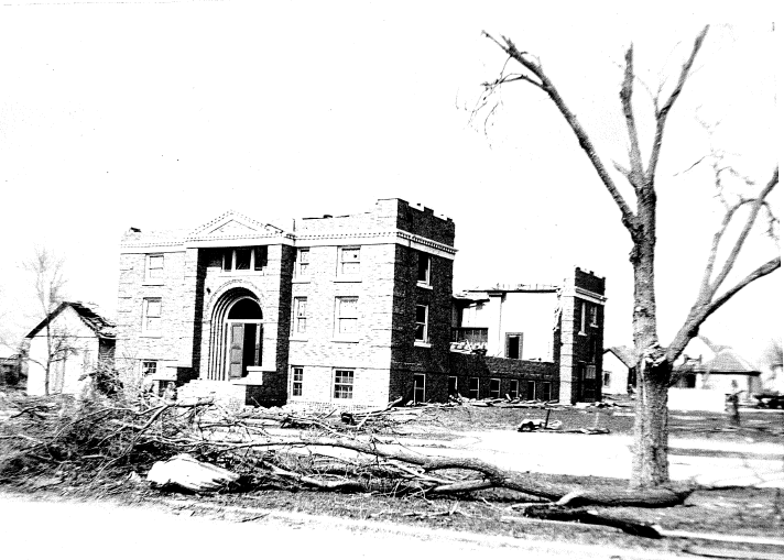
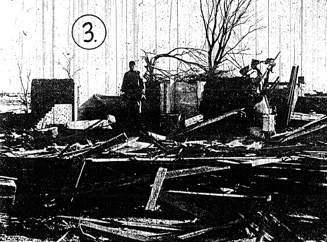
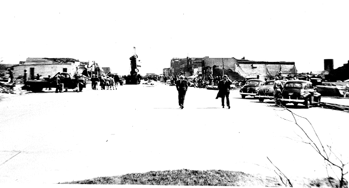
“Just another day” is how Fred Furguson described Wednesday, April 9, 1947 (Amarillo Globe-News). For a good portion of the day, the weather was cloudy and cold across Hemphill County, TX, typical of the early spring in the Texas and Oklahoma Panhandles. The forecast produced by the U.S. Weather Bureau office at Amarillo seemed to be going pretty well. The forecast printed in the April 9 morning edition of the Amarillo Daily News called for cloudy skies that morning with clearing by noon. Temperatures were expected to reach near 60° F by the late afternoon hours. The weather changed dramatically by the middle and late afternoon hours as the sunshine appeared through a broken cloud deck, allowing temperatures to warm much higher than forecast. The meteorological conditions on this day will be described in more detail later, but the environment quickly became supportive of severe thunderstorms, including tornadoes. Indeed, the worst tornado to impact the Panhandles occurred on April 9, 1947 and was part of one of the deadliest tornado outbreaks in U.S. history. This small-scale tornado outbreak is notoriously known for producing the Woodward, OK tornado that devastated that town and killed 107 people. In Texas, the same tornado was equally destructive and wiped out all of Glazier and most of Higgins. At one time there was discussion as to whether or not this was a single long-track tornado that remained on the ground for over 200 miles. However, a thorough analysis of the event determined that a family of at least five or six tornadoes most likely produced the destruction from Texas to Kansas. Nonetheless, the Glazier-Higgins-Woodward tornado is believed to have been on the ground continuously for over 100 miles. The destruction caused by the tornado outbreak was historic, and in fact, the Glazier-Higgins-Woodward tornado remains the sixth deadliest U.S. tornado. The first tornado in this outbreak began just to the west southwest of White Deer, TX around 5:42 p.m. CST and dissipated just east of Skellytown, TX. Along its 12-mile path, no one was killed, but three people were injured. Two of the people injured were on a 61-car Santa Fe Railway freight train when the tornado derailed 21 cars and three cabooses. Another person was injured when a home was shifted off its foundation and partially collapsed. Based on photographic evidence and detailed reanalysis, this tornado was 250 yards (0.14 mi) wide and rated F2 by Grazulis (1993). Before 2007, tornadoes were rated according to the Fujita-Pearson Scale that ranged from F0 (lowest rating) to F5 (highest rating). Shortly after the first tornado dissipated east of Skellytown, the second tornado began around 6:05 p.m. CST about five miles northwest of Pampa, TX. The tornado briefly lifted as it entered Roberts County, but two Santa Fe railroad signalmen at the Codman station near Miami, TX reported five separate tornadoes southwest of the city. The largest of the five tornadoes was said to be up to a mile wide. Northwest of Miami, a tornado blew a car into a bar ditch, blew away an outhouse and a garage, and knocked over a windmill. This tornado, or a separate tornado, passed about three miles northwest of Canadian, TX before taking aim on the tiny towns of Glazier, TX and Higgins, TX. The tornado first unleashed its fury on Glazier (population of 200) around 7:00 p.m. CST where it leveled the entire town except for one residence and the concrete jail. The tornado path width was 600 yards (0.34 mi) as it moved through Glazier. Around 7:40 p.m. CST, the tornado entered Higgins and destroyed half of the homes and the entire business district. Statistics about the tornado vary from source to source, but the tornado was at least responsible for 17 deaths and 40 injuries in Glazier and 51 deaths and 232 injuries in Higgins. The estimated property damage from this tornado was $1,500,000. The tornado was 2,640 yards (1.5 mi) wide at Higgins and rated F5 by Grazulis (1993). After exiting the Texas Panhandle, this tornado heavily damaged Woodward, OK before likely dissipating west of Alva, OK. The storm that produced the family of tornadoes was likely a cyclic supercell. A supercell is a large, persistent and rotating thunderstorm that has a high propensity for producing severe weather. Before the tornado struck Higgins, residents recall that baseball-sized hail pelted the town. Eyewitnesses said the tornado at Higgins sounded “like a freight train and looked like two tornadoes” (Amarillo Globe-News). Judging by the eyewitness accounts, it is possible that the tornado may have been a multiple vortex tornado, which is capable of producing localized areas of enhanced damage in small suction vortices. Debris littered the streets and grass and many buildings were reduced to piles of rubble. Veterans of World War I and II who had seen cities demolished by bombing and shell fire said they had never seen such devastation before. Temporary shelters were set up immediately after the tornado, and many volunteers worked all night picking up the dead and assisting the injured. Relief efforts were temporarily delayed on April 11 due to near blizzard conditions and four inches of snow that fell across parts Hemphill and Lipscomb Counties. Although a handful of residents call Glazier home, the town never came back. One reporter for the Amarillo Daily News wrote a chilling account of the scene at Glazier and Higgins.
“Stricken residents of Higgins and Glazier are wandering between Amarillo and Oklahoma City searching for loved ones, dead or alive, victims of the terrible tornado which leveled those two towns, as though an atomic bomb had been dropped on them, Wednesday night. Tears streaming down their cheeks, men, women and children slowly enter funeral homes, hospital and emergency stations housing the dead and injured, they lift covers from still forms. Suddenly a scream pierces the silence. A loved one has been found.”
Unfortunately, residents of Higgins and Glazier had no warning of the impending danger other than actually observing the monster tornado headed towards them. This disaster occurred at a time when the word “tornado” was prohibited from being used in forecasts due to the fear of public panic and complacency if the forecast turned out to be wrong. Even if tornado warnings had been permitted at the time, a deficiency in technology would likely still not have been able to provide any advance warning. |
||||
|
||||
|
||||
|
||||
| Meteorological Analysis | ||||
|
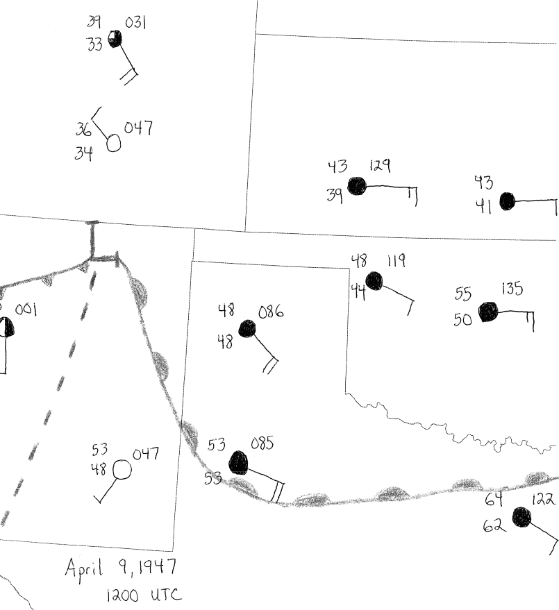
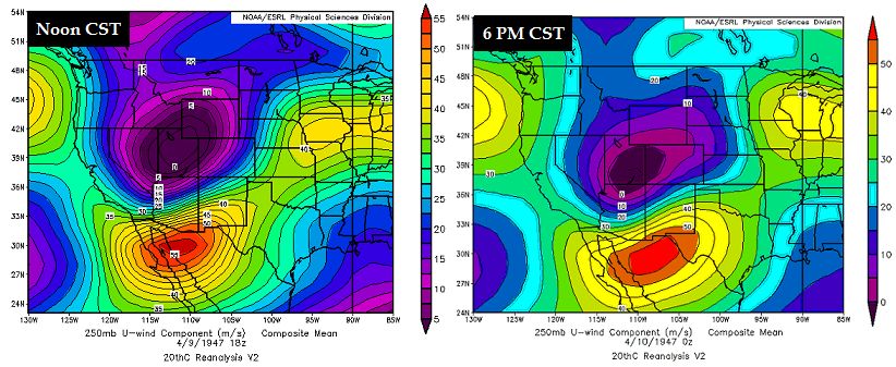
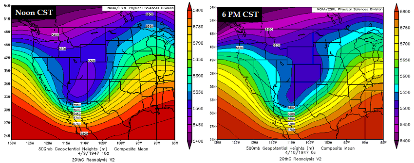
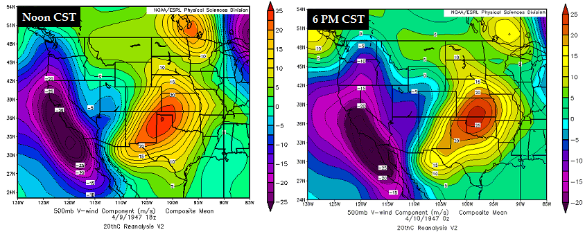
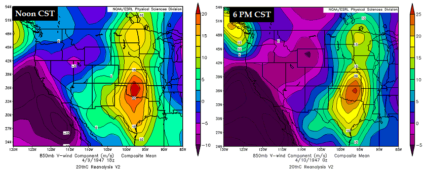
The weather during the late afternoon and evening hours on April 9th likely caught many people by surprise considering the weather conditions earlier in the day. A low stratus deck blanketed most of the area and there were some areas of dense fog in the morning. As a result, temperatures were rather chilly through the early afternoon hours with many locations stuck in the upper 40s to middle 50s. A cold front had pushed south of the area a couple of days earlier on April 7th and stalled across the South Plains of Texas. As a deep upper-level trough began to swing into the Four Corners region on April 9th, it allowed the front to lift north as a warm front. The 250 mb chart indicated a trough across the Desert Southwest on April 9th with a potent jet streak nosing into West Texas by 6 p.m. CST (Figure 1). The Panhandles were in the left exit region of the upper-level jet streak, which likely enhanced the vertical motion for ascent. The same positively tilted, deep trough was noted at 500 mb (Figure 2) moving across the Four Corners throughout the day. 500 mb height falls and cooling temperatures aloft likely steepened mid-level lapse rates as the day progressed. 500 mb winds (Figure 3) strengthened through the day as a mid-level jet ejected into the Central Plains through the day. Strong mid-level flow was noted across the northeastern Panhandles at 6 p.m. CST, and this undoubtedly enhanced deep layer shear. The same trend can be observed with winds at 700 mb (Figure 4). The strongest core of 850 mb winds also was located across the Central Plains (Figure 5). The core of the low-level jet steadily progressed eastward through the day, but a lingering area of strong low-level flow was still present over the far northeastern portion of the Panhandles. These strong low-level winds likely enhanced low-level mesocyclones as storms developed. The synoptic scale environment was quite supportive of deep layer ascent. The environment was also very favorable for organized thunderstorm development, including severe thunderstorms, due to the speed shear. However, the surface environment was not ripe for severe weather for most of the day as strong upslope surface winds and abundant low-level moisture contributed to a widespread low cloud deck and dense fog. A surface analysis at 1200 UTC (Figure 6) indicated a surface low was present across Northeast New Mexico with an attendant cold front trailing to the southwest. A dryline extended southward from the low and was likely located from Springer, NM to Alamogordo. A warm front was draped from near Raton, NM to Sherman, TX. The warm sector was characterized by abundant surface moisture as evidenced by a dew point temperature of 62° F at Dallas, TX. Meanwhile, Denver and Pueblo, CO were deeply entrenched in the cold sector where the surface air temperature was below 40° F. Across the northeastern portion of the Panhandles, air temperatures and dew points were below 50° F. |
||||
|
||||
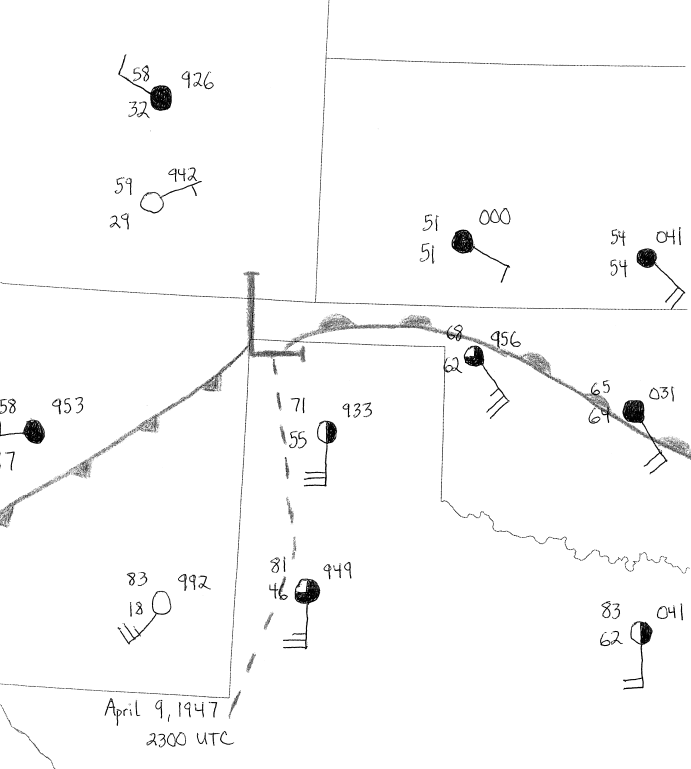
| By 2300 UTC, the surface low had moved slightly east and was likely centered over the far western Oklahoma Panhandle (Figure 7). A cold front had sagged southward and had pushed through Albuquerque, NM. More importantly, a dryline had sharpened and bulged slightly across the Texas South Plains. It’s possible that this dryline bulge may have enhanced low-level convergence and helped to initiate thunderstorms by the middle to late afternoon hours. Finally, the warm front had gotten a decent northward surge through the day as the southerly flow increased across the warm sector. This warm front likely played a pivotal role in sustaining the supercell thunderstorm that would spawn the family of tornadoes from the Northeast Texas Panhandle into Southwest Kansas. Due to the sparse surface observation network, it’s almost impossible to pinpoint the exact position of the surface features. | ||||
|
||||
|
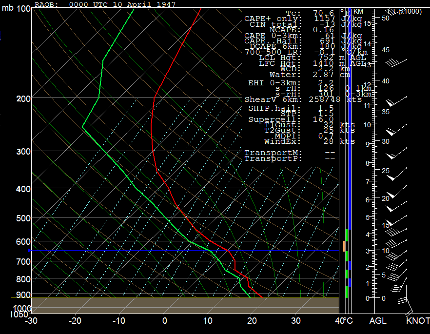
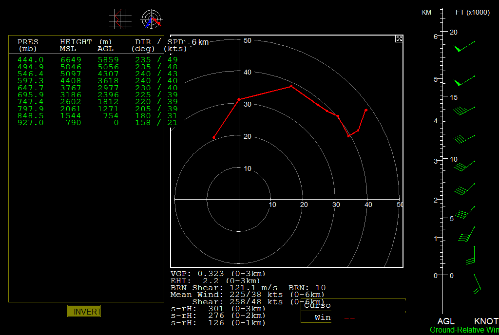
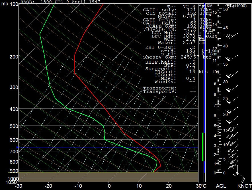
Vertical sounding profiles were constructed for a point near Glazier, TX using reanalysis and surface data. The sounding at 1800 UTC (Figure 8) showed a classic cool sector profile with a relatively shallow moist, stable layer from the surface to 800 mb. Above that layer, lapse rates were relatively steep at 7.2° C/km, indicating some elevated instability was present. Although not shown, a parcel lifted from 800 mb yielded a most unstable CAPE in excess of 650 J/kg. With the approaching mid-level jet streak, impressive speed shear and some directional shear contributed to deep layer shear magnitudes of 57 kt (Figure 9). There was also some low-level speed and directional shear with 0-1 km storm relative helicity values around 135 m2/s2. Although the environment was not overly supportive of a significant threat of severe weather at this time, the environment clearly supported an increased threat if sufficient heating materialized. Once the warm front began to lift northward, breaks in the clouds allowed temperatures to jump into the mid to possibly upper 60s by the late afternoon hours across Hemphill and Lipscomb Counties. Reconstructing the 0000 UTC (Figure 10) sounding revealed that the stable low-level layer at 1800 UTC had been eroded by the surface heating. Height falls and cooling associated with the approaching longwave trough steepened mid-level lapse rates to 8.1° C/km. As a result, the air mass became moderately unstable with mixed layer CAPE values in excess of 1,100 J/kg. Although deep layer wind shear had decreased slightly, there was more than sufficient shear for supercells to develop given the degree of buoyancy present. Low-level winds had veered slightly, which accounted for a decrease in 0-1 km storm relative helicity (Figure 11). However, with the warm front being in the vicinity, it’s likely that the boundary locally enhanced the magnitude of wind shear in the lowest kilometer. Furthermore, 0-3 km CAPE increased to 61 J/kg, mixed layer CIN had been reduced to -13 J/kg, and LCL and LFC heights were 752 m AGL and 1410 m AGL, respectively. In context with the synoptic and mesoscale environment, these parameters clearly indicate the potential for tornadoes, and even significant tornadoes, based on the results of Rasmussen (2003), Thompson et al. (2002) and Davies (2002). |
||||
|
||||
|
||||
|
A volatile combination of synoptic and mesoscale conditions coupled together to produce one of the deadliest tornado outbreaks in U.S. history on April 9, 1947. In the worst tornado ever documented in the Texas and Oklahoma Panhandles, the town of Glazier was completely wiped off the map and Higgins was decimated. Although the Panhandles have since never seen a tornado as powerful, the same situation may repeat itself again someday. It is anticipated that residents and forecasters will be much better prepared the next time it happens. |
||||
| Acknowledgements | ||||
| Thanks to Michael Scotten, Lead Forecaster at NWS Norman, for providing valuable suggestions that improved the reading of this manuscript. Thanks to Jose Garcia, Meteorologist-In-Charge at NWS Amarillo, for reviewing this manuscript and providing some of the historical photos and newspaper clippings included in this manuscript. Thanks to the staff at the Amarillo Public Library for assisting with the microfilm archives. NOAA/NCDC provided integrated hourly surface data that were used to construct the surface maps. The 20th Century Reanalysis Version 2 provided by NOAA/OAR/ESRL PSD was used to construct the upper air maps, soundings, and hodographs. Support for the Twentieth Century Reanalysis Project dataset is provided by the U.S. Department of Energy, Office of Science Innovative and Novel Computational Impact on Theory and Experiment (DOE INCITE) program, the Office of Biological and Environmental Research (BER), and the National Oceanic and Atmospheric Administration Climate Program Office." The Amarillo Daily News/Amarillo Globe-News provided a wealth of information and pictures that helped make this reconstruction possible. The RAwinsonde OBservation program was used to construct the soundings and hodographs. |
||||
| References | ||||
| Albright, Max. “Remembering the killer.” Amarillo Daily News 9 April 1987: D3. Print. Davies, J. M., 2002: On low-level thermodynamic parameters associated with tornadic and non-tornadic supercells. Preprints, 21st Conference Severe Local Storms, San Antonio, TX. Ehrle, Michael. “April 9, 1947 ‘Just another day’ in Higgins...” Amarillo Daily News 9 April 1982: D1. Print. Grazulis, T. P., 1993: Significant Tornadoes 1680-1991. Environmental Films. St. Johnsbury, Vermont. 1336 pp. Rasmussen, E. N., 2003: Refined supercell and tornado forecast parameters. Weather and Forecasting, 18, 530-535. Thompson, R.L., R. Edwards and J.A. Hart, 2002: An Assessment of Supercell and Tornado Forecast Parameters with RUC-2 Model Close Proximity Soundings. Preprints, 21st Conference Severe Local Storms, San Antonio TX. |

