
Dangerous and extreme heat will remain across portions of the Central U.S. this week, persisting across the Mid to Lower Mississippi Valleys, Gulf Coast, Southern Plains and portions of Texas. A heat wave over the Southwest will intensify late this week. Severe thunderstorms and flash flooding will spread from the Great Lakes/Ohio Valley to the Mid-Atlantic and Northeast the next few days. Read More >
|
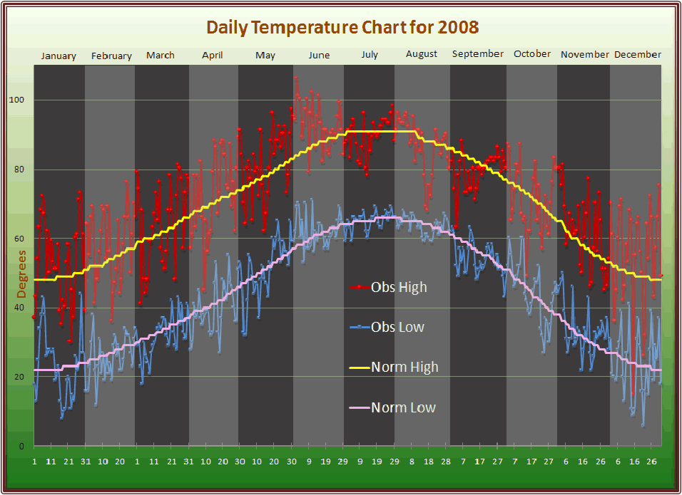
2008 Weather Year in Review The National Weather Service in Amarillo has compiled a summary of notable weather records and events for the Texas and Oklahoma Panhandles for 2008. Included in this release are all the monthly statistics, records, and weather highlights for 2008. Also included is a graph depicting the daily temperatures for 2008. Click HERE to view this graph. 2008 started off warm and dry. Every month from January through June received above average temperatures while January, March, April and May all observed below average precipitation. Snowfall totals were also down this year with March coming in with the most observed snow. The dry pattern continued during the spring providing a much less active severe weather season than the Panhandles witnessed in 2007. Spring storm systems brought more wind than rain, leaving much of the area in a drought. There were still a few significant severe weather events, but the total number of tornados for the year was 12. This is about 50 fewer tornados than we observed across the Panhandles in 2007. The warm and windy conditions combined with the ongoing drought to produce a few wildfires. Fortunately, most of the injuries reported as a result of the wildfires were minor. The hottest period occurred in the early to middle part of June when temperatures routinely topped 100 degrees in many parts of the High Plains. The dry and abnormally hot trend finally began to erode in mid June when thunderstorm activity increased. The remnants of a few tropical systems then impacted the Panhandle in July and August providing abundant rainfall which resulted in flooding in some areas. The wet pattern continued through September and October with cooler than average temperatures as well. In fact, the five month period from June through October was the 9th wettest summer and early fall on record for Amarillo. This moist air helped alleviate some of the drought conditions occurring across the Panhandles especially across the western Oklahoma Panhandle where a severe drought was in place. January February Wildfires were again the main story in February and ongoing drought conditions persisted across the Panhandles. Wildfires scorched another 8,000 acres in February but fortunately there were no reports of injuries or fatalities relating to the fires. On February 5th, winter weather impacted the Panhandles creating slick roads and limited visibilities. A car accident relating to the winter weather resulted in five fatalities. April The first tornado of the year developed in April. The tornado briefly touched down on April 26th near the town of Perryton resulting in no injuries or damage. There were a few severe thunderstorms in April but the strongest storm only produced hail stones up to the size of ping pong balls. A strong dust devil formed on April 3rd in eastern Amarillo. This dust devil moved near the Clements Prison Unit and blew out the windows in several cars. May As usual, the number of severe storms increased in May but there were still fewer than normal severe weather events due to the persistent dry conditions. In fact, severe thunderstorms were only observed on six days in May. Six tornados touched down in May, all of which were rated as EF0’s and produced no damage or injuries. The two most active severe weather days in May were the 25th and 26th. May 25th was characterized more by the strong winds than hail. Thunderstorm wind gusts in excess of 60 and 70 mph were common across the Panhandles along with 4 of the 6 May tornados. May 26th witnessed the other 2 tornados along with a number of baseball size hail reports mostly confined to the southern Texas Panhandle.
Warm air remained in place through most of June providing above normal average temperatures. Further, Amarillo witnessed record setting high temperatures on the 2nd and 11th, while record tying high temperatures occurred on the 3rd and 4th. However, the dry pattern finally began to erode for most of the Panhandles leading to above normal precipitation for the month in Amarillo. Unfortunately, the drier conditions remained across the Oklahoma Panhandle which combined with the hot temperatures to create prime wildfire conditions. A large wildfire of over 5,000 acres burned in Texas County near the town of Guymon. Firefighters from Texas, Oklahoma and Kansas all responded to this fire. July The moisture train continued to roll through the Panhandles in July. Energy from the remnants of Hurricane Dolly moved through the Panhandles in late July. The combination of this remnant energy and moisture in place caused severe thunderstorms and heavy rain to develop on July 28th. Amarillo received over 3 inches of rain from the 28th through the 29th. Most of the severe weather occurred in Potter and Randall counties with the strongest storm producing golf ball size hail near the city of Canyon on the 28th. July was also the first month of the year to experience below normal average temperatures. In addition, the nearly five inches of rain observed in Amarillo during the month places this July as the 15th wettest on record. August The cooler and wetter trend continued through August. Over four inches of rain fell in Amarillo during August with over five inches of rain in the Oklahoma Panhandle. Heavy rain and a few severe thunderstorms developed from the 11th through the 18th of the month. Remnant moisture and energy from Hurricane Edouard trickled into the Panhandles during this period helping to provide rain for every location in the Panhandles. The highest rainfall total was in the town of Hereford where 7.82 inches of rain fell while the lowest total of 2.0 inches fell in Dalhart. The widespread heavy rain resulted in flooding in Lipscomb County on the 14th, Deaf Smith County on the 16th, and Beaver, Ochiltree, Lipscomb and Armstrong Counties on the 18th. The Hereford Fire Department performed high water rescues for residents of the San Jose community just outside of Hereford. October Dying tropical storms or hurricanes are somewhat of a rarity for the Panhandles. However, 2008 experienced the remnants of three Hurricanes. The last such instance occurred in October when the remnants of Norbert, a Pacific Hurricane which first impacted the Baja Peninsula of Mexico, reached the Panhandles between the 11th and the 14th of the month. Amarillo received over two inches of rain during this four day period alone which is well over the average rainfall for the entire month. Temperatures moderated throughout the month which resulted in an average monthly temperature that was exactly normal. November The dry and warm conditions returned to the Panhandles in November. Two small wildfires develop but neither burned more than 300 acres. Measurable rain fell on two days during the month with a sixteen day dry period between the two rainy days. December One of the bigger stories of the month was the near record high temperatures on Christmas Day. Warm, windy and dry conditions were normal during December with a few cold outbreaks mixed in. The first cold arctic airmass of the year filtered into the Panhandles on the 14th and 15th of the month. The temperature fell fifty-four degrees on the 14th from a high of sixty-five to a low of eleven. Low temperatures fell into the single digits while the high temperature on the 15th only climbed to fifteen degrees. Another cold air outbreak hit the Panhandles on the 20th through the 22nd. The coldest morning of the year came on the 21st when Amarillo bottomed out at six degrees. |

