National Weather Service United States Department of Commerce

Thunderstorms from the Plains into the Central Appalachians; Heavy Rain in the Central Gulf Coast; Heat Across Portions of the East

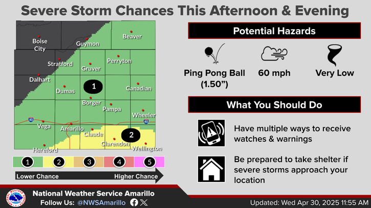
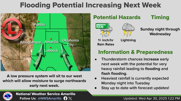
Widespread showers and thunderstorms are likely from from northeast New Mexico/Southeast Colorado, eastward into the Central Plains through the Central Appalachians. Slow moving low to bring heavy rainfall to the Central Gulf Coast into the weekend. Dangerous heat is expected from the Lower Mississippi Valley, Tennessee Valley, Ohio Valley into the Mid-Atlantic and Northeast. Read More >

Click a location below for detailed forecast.

Last Map Update: Thu, Jul 17, 2025 at 12:46:33 am CDT

Thunderstorms are likely across the northern combined Panhandles this evening through the overnight hours tonight. Some of the thunderstorms could produce heavy rainfall with at least a 30-50% chance for rainfall rates to exceed 1 inch per hour. This heavy rainfall could lead to flash flooding with isolated rainfall totals upwards of 3-5 inches. If you encounter flooding, remember to turn around and do not drive through it.
There is a low chance for severe thunderstorms tonight across the northern Panhandles. The main hazard with any severe storms will be wind gusts up to 70 mph with a lower chance for large hail up to quarters.
Severe storms may form late this afternoon but will most likely be this evening through early Friday morning if any storms are able to become severe tonight.
Summer heat is on the way early next week for the Texas and Oklahoma Panhandles. High temperatures will reach the upper 90s at least with a low to medium chance for hitting the 100 degree mark across most of the area on Monday and Tuesday.

Text Product Selector (Selected product opens in current window)


Current Observations ( )
Location Sky/Weather Temp (°F) Dewpt (°F) RH (%) Wind (mph) Pressure (inHg) Remarks
 Amarillo
N/A
N/A
N/A
N/A
N/A
N/A
N/A
 Borger
N/A
N/A
N/A
N/A
N/A
N/A
N/A
 Canadian
N/A
N/A
N/A
N/A
N/A
N/A
N/A
 Dalhart
N/A
N/A
N/A
N/A
N/A
N/A
N/A
 Dumas
N/A
N/A
N/A
N/A
N/A
N/A
N/A
 Guymon
N/A
N/A
N/A
N/A
N/A
N/A
N/A
 Hereford
N/A
N/A
N/A
N/A
N/A
N/A
N/A
 Pampa
N/A
N/A
N/A
N/A
N/A
N/A
N/A
 Perryton
N/A
N/A
N/A
N/A
N/A
N/A
N/A
 Amarillo 9NNE
N/A
N/A
N/A
N/A
N/A
N/A
N/A
 Amarillo 7SSE
N/A
N/A
N/A
N/A
N/A
N/A
N/A
 Bootleg 11WNW
N/A
N/A
N/A
N/A
N/A
N/A
N/A
 Canadian 6E
N/A
N/A
N/A
N/A
N/A
N/A
N/A
 Clarendon 2WSW
N/A
N/A
N/A
N/A
N/A
N/A
N/A
 Claude 12SW
N/A
N/A
N/A
N/A
N/A
N/A
N/A
 Hereford 2NW
N/A
N/A
N/A
N/A
N/A
N/A
N/A
 McLean 1E
N/A
N/A
N/A
N/A
N/A
N/A
N/A
 Palo Duro SP
N/A
N/A
N/A
N/A
N/A
N/A
N/A
 Pampa 2E
N/A
N/A
N/A
N/A
N/A
N/A
N/A
 Umbarger 3NNE
N/A
N/A
N/A
N/A
N/A
N/A
N/A
Note: "N/A" or "MISG" will be displayed if values are not available. In the LOCATION column, click on links for a list of recent observations at sites of interest. In the WIND column, VRB is "variable" and G is "gust". In the REMARKS column, HX is "heat index", WCI is "wind chill index", and VSB is "visibility" (if shown).


Aviation Drought Fire Weather Hydrology Severe Weather Winter Weather
 
Climate Graphs Hourly Forecast Long Range Local Model Data Precip Maps Office Webcam
 
Education Local Research News Skywarn Weather Calculator Weather Radio