Overview
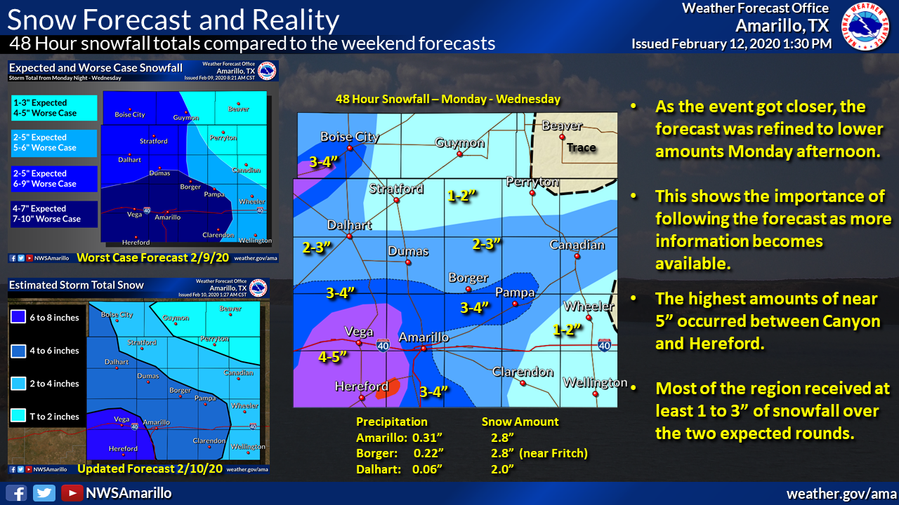
A dynamic upper level low pressure system moved slowly to the east across far southern Arizona and provided two rounds of snowfall across the panhandles. Out ahead of the main center of the upper level low, persistent moisture from the eastern Pacific surged northeast into the Panhandle’s region. Coupled with the slow propagation of the system to the east, two main disturbances moved northeast ahead of the main upper level low which was a favorable area for large scale lift and in return, snowfall developed across the panhandles.
The first round of snowfall occurred early Tuesday morning on the 11th. Areas of light snow moved northeast and spread across the northwestern and north central panhandles bringing about 1-3 inches of snow with the higher amounts across the northwestern panhandles. A more solid band of snow developed across portions of the southern and southeastern panhandles setting up south of Amarillo and extending northeast to Gray & Wheeler Counties. This band produced anywhere from 1 to near 4 inches for parts of Armstrong County. The second round of snow started late Tuesday night on the 11th and continued overnight before ending the morning of Wednesday the 12th. This second round of snow was more confined to the central and southern Texas panhandle where an area of snow moved southwest to northeast across the aforementioned area before exiting the Panhandles early Wednesday morning. Some localized banding of snowfall produced moderate to heavy snowfall rates at times. Snowfall totals ranged from 2-4 inches for this second batch of snow. Both morning commutes on the 11th and 12th resulted in travel impacts across the Panhandles that resulted in multiple accidents and slick road conditions. The main source of precipitation for this upper level system finally exited the region mid-morning on Wednesday the 12th.
Snow/Ice
 |
Photos & Video
.jpg) |
 |
 |
 |
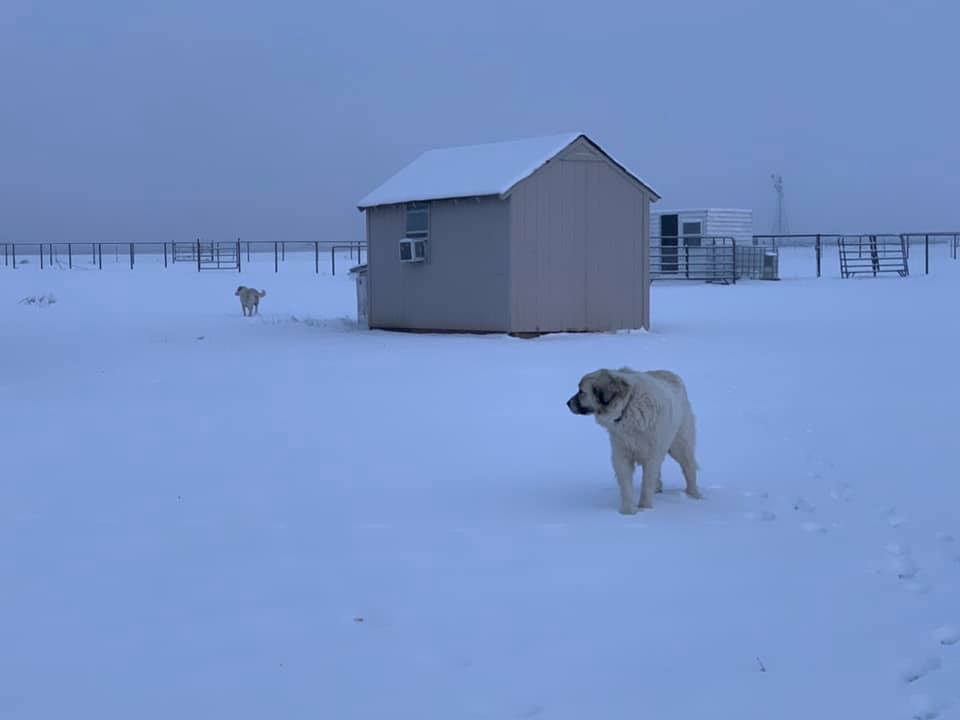
| Panhandle, TX (Christina Barton) |
Boise City, OK (David Johnson) |
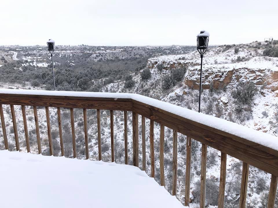
Timbercreek Canyon, TX (Patricia Springs ) |
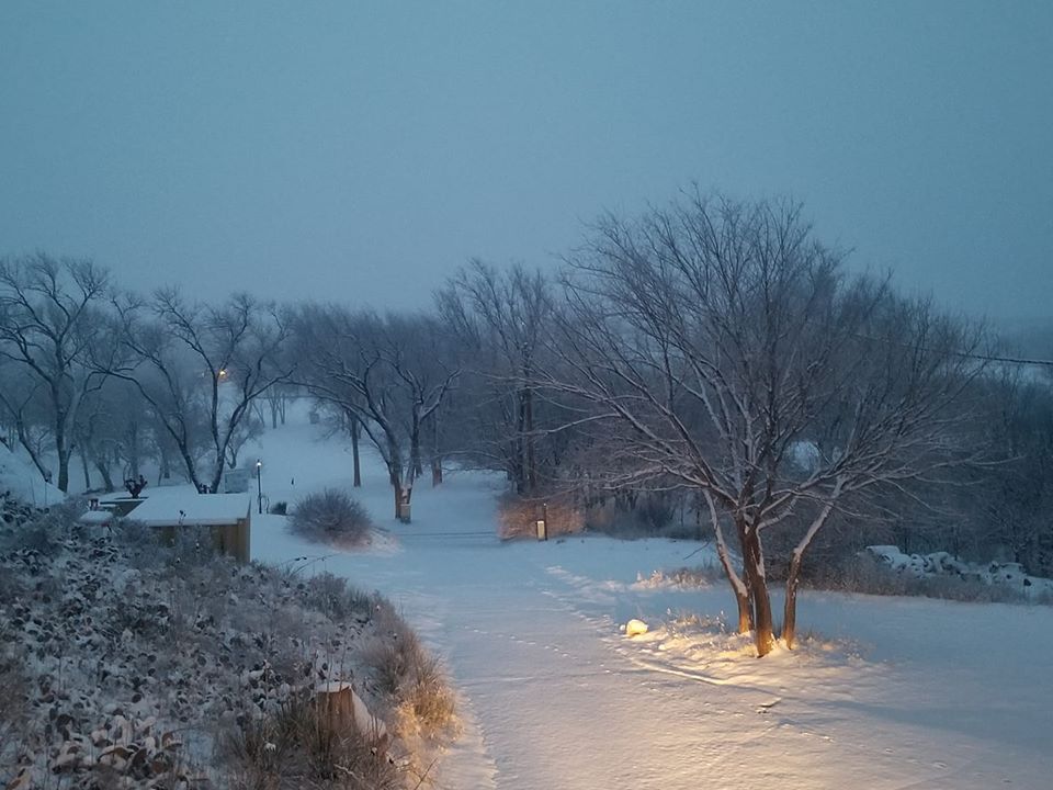
Near Amarillo (Carson County) (Lindsay Riefers) |
 |
 |
 |
 |
| Canyon, TX (Dulce Flores) |
NE Amarillo (Linda Moore) |
Country Club Canyon (Bobbi Castillo) |
Near Amarillo (Carson County) (Lindsay Riefers) |
Radar
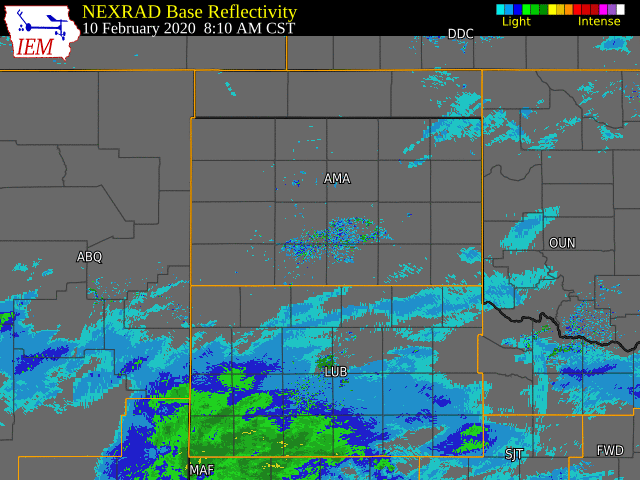 |
| Radar loop from the morning of February 10, 2020 through the early afternoon February 12, 2020. This imagery is from the Iowa Environmental Mesonet interactive radar archive. |
Storm Reports
..TIME... ...EVENT... ...CITY LOCATION... ...LAT.LON...
..DATE... ....MAG.... ..COUNTY LOCATION..ST.. ...SOURCE....
..REMARKS..
0417 PM SNOW 30 NW MIAMI 36.00N 101.02W
02/10/2020 E1.5 INCH ROBERTS TX PUBLIC
MODERATE SNOW. LOW VISIBILITY.
0750 PM SNOW CANADIAN 35.91N 100.38W
02/10/2020 E1.7 INCH HEMPHILL TX PUBLIC
0630 AM SNOW DALHART 36.06N 102.52W
02/11/2020 M1.5 INCH DALLAM TX CO-OP OBSERVER
0650 AM SNOW TEXLINE 36.38N 103.02W
02/11/2020 M3.5 INCH DALLAM TX CO-OP OBSERVER
3.5 INCHES OF SNOW ON THE GROUND IN TEXLINE. HWY 87 AT
TEXLINE IS COVERED WITH SNOW.
0700 AM SNOW TEXLINE 36.38N 103.02W
02/11/2020 M3.7 INCH DALLAM TX COCORAHS
0700 AM SNOW 5 E FRITCH 35.63N 101.51W
02/11/2020 M1.2 INCH HUTCHINSON TX COCORAHS
0700 AM SNOW 1 NNE BORGER 35.66N 101.40W
02/11/2020 M1.0 INCH HUTCHINSON TX SOCIAL MEDIA
0700 AM SNOW 2 WNW CANYON 34.99N 101.95W
02/11/2020 M2.0 INCH RANDALL TX NWS EMPLOYEE
0743 AM SNOW 2 WNW WHEELESS 36.73N 102.93W
02/11/2020 M2.3 INCH CIMARRON OK COCORAHS
0743 AM SNOW 2 WSW SANFORD 35.69N 101.57W
02/11/2020 E1.0 INCH HUTCHINSON TX OTHER FEDERAL
0749 AM SNOW BORGER 35.66N 101.40W
02/11/2020 M1.0 INCH HUTCHINSON TX PUBLIC
0800 AM SNOW 3 ESE FELT 36.56N 102.73W
02/11/2020 M2.0 INCH CIMARRON OK COCORAHS
0800 AM SNOW 4 NNE BLACK MESA PARK 36.91N 102.86W
02/11/2020 M2.0 INCH CIMARRON OK COCORAHS
0800 AM SNOW CANYON 34.98N 101.93W
02/11/2020 M1.0 INCH RANDALL TX CO-OP OBSERVER
0900 AM SNOW BOISE CITY 36.73N 102.51W
02/11/2020 M3.0 INCH CIMARRON OK PUBLIC
0900 AM SNOW 1 WSW BUSHLAND 35.19N 102.08W
02/11/2020 M1.5 INCH POTTER TX CO-OP OBSERVER
0900 AM SNOW WOLF CREEK PARK 36.21N 100.65W
02/11/2020 M1.3 INCH OCHILTREE TX SOCIAL MEDIA
0930 AM SNOW 3 E CANYON 34.98N 101.87W
02/11/2020 M2.0 INCH RANDALL TX NWS EMPLOYEE
0931 AM SNOW 1 S CANYON 34.96N 101.92W
02/11/2020 M2.0 INCH RANDALL TX SOCIAL MEDIA
0935 AM SNOW 5 NW AMARILLO 35.26N 101.88W
02/11/2020 M1.0 INCH POTTER TX SOCIAL MEDIA
0938 AM SNOW GRUVER 36.26N 101.41W
02/11/2020 E1.0 INCH HANSFORD TX SOCIAL MEDIA
0947 AM SNOW GOODWELL 36.59N 101.63W
02/11/2020 E1.0 INCH TEXAS OK SOCIAL MEDIA
0953 AM SNOW WAYSIDE 34.79N 101.55W
02/11/2020 E3.5 INCH ARMSTRONG TX EMERGENCY MNGR
1005 AM SNOW 1 W DUMAS 35.86N 101.96W
02/11/2020 E1.0 INCH MOORE TX SOCIAL MEDIA
1035 AM SNOW LAKE TANGLEWOOD 35.06N 101.78W
02/11/2020 M1.5 INCH RANDALL TX SOCIAL MEDIA
1040 AM SNOW 1 N BUSHLAND 35.20N 102.06W
02/11/2020 M2.5 INCH POTTER TX SOCIAL MEDIA
1049 AM SNOW CLAUDE 35.11N 101.36W
02/11/2020 E1.0 INCH ARMSTRONG TX SOCIAL MEDIA
1049 AM SNOW SUNRAY 36.02N 101.82W
02/11/2020 M1.0 INCH MOORE TX SOCIAL MEDIA
1144 AM SNOW 1 S FRITCH 35.63N 101.60W
02/11/2020 E1.5 INCH HUTCHINSON TX SOCIAL MEDIA
1147 AM SNOW VEGA 35.25N 102.43W
02/11/2020 E2.0 INCH OLDHAM TX LAW ENFORCEMENT
1232 PM SNOW 1 NE PAMPA 35.56N 100.95W
02/11/2020 E1.0 INCH GRAY TX TRAINED SPOTTER
1200 AM SNOW 7 SW AMARILLO 35.15N 101.92W
02/12/2020 E2.0 INCH RANDALL TX SOCIAL MEDIA
0100 AM SNOW HEREFORD 34.82N 102.40W
02/12/2020 E2.5 INCH DEAF SMITH TX LAW ENFORCEMENT
SHERIFFS OFFICE REPORTED AT LEAST 2 INCHES ON THE
GROUND AT MIDNIGHT WITH AT LEAST ANOTHER HALF AN INCH TO
AN INCH POSSIBLE SINCE THEN.
0110 AM SNOW 5 NNE AMARILLO 35.26N 101.78W
02/12/2020 M2.0 INCH POTTER TX SOCIAL MEDIA
0115 AM SNOW VEGA 35.25N 102.43W
02/12/2020 E2.5 INCH OLDHAM TX LAW ENFORCEMENT
SHERIFFS OFFICE REPORTED AT LEAST 2 TO 3 INCHES OF SNOW
FELL WITH THIS RECENT BAND.
0145 AM SNOW 6 WSW AMARILLO 35.16N 101.90W
02/12/2020 M2.0 INCH RANDALL TX SOCIAL MEDIA
0205 AM SNOW PANHANDLE 35.35N 101.38W
02/12/2020 E2.5 INCH CARSON TX LAW ENFORCEMENT
LOCAL SHERIFFS OFFICE INDICATED THAT NEW SNOW AMOUNTS
ON THE GROUND RANGE FROM 2 TO 3 INCHES. SOME REPORTS ON
SOCIAL MEDIA MATCH UP WITH THE ESTIMATES AS WELL.
0210 AM SNOW CLAUDE 35.11N 101.36W
02/12/2020 E1.0 INCH ARMSTRONG TX LAW ENFORCEMENT
SHERIFFS OFFICE INDICATED THAT ABOUT AN INCH OF NEW
SNOW HAD FALLEN IN THE CLAUDE AREA.
0215 AM SNOW PAMPA 35.55N 100.96W
02/12/2020 E2.5 INCH GRAY TX LAW ENFORCEMENT
SHERIFFS OFFICE IN PAMPA ESTIMATED 2 TO 3 INCHES OF NEW
SNOW ON THE GROUND. LIGHT SNOW STILL FALLING AT THE
TIME.
0230 AM SNOW LIPSCOMB 36.23N 100.27W
02/12/2020 E1.0 INCH LIPSCOMB TX LAW ENFORCEMENT
SHERIFFS OFFFICE CURRENTLY REPORTING BIG FLAKES
FALLING. ABOUT AN INCH ON THE GRASS, WITH SNOW JUST NOW
STARTING TO STICK AND COVER THE ROADS AND SIDEWALKS.
0400 AM SNOW 5 SW AMARILLO 35.16N 101.88W
02/12/2020 M2.5 INCH RANDALL TX BROADCAST MEDIA
0500 AM SNOW 7 ESE BUSHLAND 35.17N 101.94W
02/12/2020 M2.0 INCH RANDALL TX NWS EMPLOYEE
MEASUREMENT ONLY INCLUDES SNOW TUESDAY NIGHT SINCE ALL
SNOW TUESDAY MORNING HAD MELTED
0530 AM SNOW TEXLINE 36.38N 103.02W
02/12/2020 M1.0 INCH DALLAM TX CO-OP OBSERVER
0530 AM SNOW 6 WSW AMARILLO 35.18N 101.92W
02/12/2020 M2.0 INCH POTTER TX COCORAHS
0530 AM SNOW TEXLINE 36.38N 103.02W
02/12/2020 M4.5 INCH DALLAM TX CO-OP OBSERVER
48 HOUR SNOWFALL TOTAL
0555 AM SNOW FOLLETT 36.43N 100.14W
02/12/2020 M2.0 INCH LIPSCOMB TX CO-OP OBSERVER
48 HOUR SNOWFALL TOTAL
0600 AM SNOW 1 W SANFORD 35.70N 101.55W
02/12/2020 M1.0 INCH HUTCHINSON TX CO-OP OBSERVER
0600 AM SNOW 1 W SANFORD 35.70N 101.55W
02/12/2020 M1.7 INCH HUTCHINSON TX CO-OP OBSERVER
48 HOUR SNOWFALL TOTAL
0600 AM SNOW 7 ENE AMARILLO 35.23N 101.71W
02/12/2020 M2.8 INCH POTTER TX OFFICIAL NWS OBS
48 HOUR SNOWFALL TOTAL
0630 AM SNOW 1 N HEREFORD 34.84N 102.40W
02/12/2020 M4.2 INCH DEAF SMITH TX COCORAHS
0630 AM SNOW 1 N HEREFORD 34.84N 102.40W
02/12/2020 M4.7 INCH DEAF SMITH TX COCORAHS
48 HOUR SNOWFALL TOTAL
0630 AM SNOW DALHART 36.06N 102.52W
02/12/2020 M2.0 INCH DALLAM TX CO-OP OBSERVER
48 HOUR SNOWFALL TOTAL
0656 AM SNOW 1 NE GRUVER 36.26N 101.41W
02/12/2020 M1.0 INCH HANSFORD TX CO-OP OBSERVER
0656 AM SNOW 1 NE GRUVER 36.26N 101.41W
02/12/2020 M1.5 INCH HANSFORD TX CO-OP OBSERVER
48 HOUR SNOWFALL TOTAL
0700 AM SNOW 5 WSW AMARILLO 35.18N 101.90W
02/12/2020 M2.5 INCH RANDALL TX COCORAHS
0700 AM SNOW 2 ENE HEREFORD 34.84N 102.36W
02/12/2020 M3.8 INCH DEAF SMITH TX COCORAHS
0700 AM SNOW 2 ENE HEREFORD 34.84N 102.36W
02/12/2020 M4.3 INCH DEAF SMITH TX COCORAHS
48 HOUR SNOWFALL TOTAL
0700 AM SNOW 5 E FRITCH 35.63N 101.51W
02/12/2020 M1.6 INCH HUTCHINSON TX COCORAHS
0700 AM SNOW 5 E FRITCH 35.63N 101.51W
02/12/2020 M2.8 INCH HUTCHINSON TX COCORAHS
48 HOUR SNOWFALL TOTAL
0719 AM SNOW 7 NW TIMBERCREEK CANYON 35.12N 101.92W
02/12/2020 M3.0 INCH RANDALL TX NWS EMPLOYEE
0720 AM SNOW 6 SW AMARILLO 35.15N 101.89W
02/12/2020 M3.0 INCH RANDALL TX NWS EMPLOYEE
0724 AM SNOW PANHANDLE 35.35N 101.38W
02/12/2020 E2.5 INCH CARSON TX SOCIAL MEDIA
0726 AM SNOW CANYON 34.98N 101.92W
02/12/2020 E2.0 INCH RANDALL TX SOCIAL MEDIA
0746 AM SNOW 4 NW WASHBURN 35.22N 101.61W
02/12/2020 E2.5 INCH CARSON TX SOCIAL MEDIA
0750 AM SNOW 4 E CANYON 34.98N 101.85W
02/12/2020 E2.0 INCH RANDALL TX SOCIAL MEDIA
0800 AM SNOW 4 NNE BLACK MESA PARK 36.91N 102.86W
02/12/2020 M2.0 INCH CIMARRON OK COCORAHS
48 HOUR SNOWFALL TOTAL. NO MEASURABLE SNOW FELL TUESDAY
NIGHT AT THIS LOCATION.
0800 AM SNOW CANYON 34.98N 101.93W
02/12/2020 M2.0 INCH RANDALL TX CO-OP OBSERVER
48 HOUR SNOWFALL TOTAL
0800 AM SNOW 1 WSW BUSHLAND 35.19N 102.08W
02/12/2020 M3.5 INCH POTTER TX CO-OP OBSERVER
48 HOUR SNOWFALL TOTAL
0800 AM SNOW 2 WNW WHEELESS 36.73N 102.93W
02/12/2020 M2.3 INCH CIMARRON OK COCORAHS
48 HOUR SNOWFALL TOTAL
0900 AM SNOW 2 SSW HEREFORD 34.79N 102.41W
02/12/2020 M4.0 INCH DEAF SMITH TX COCORAHS
48 HOUR SNOWFALL TOTAL
0903 AM SNOW AMARILLO 35.20N 101.82W
02/12/2020 M4.2 INCH POTTER TX TRAINED SPOTTER
48 HOUR SNOWFALL TOTAL. 2.75" FELL LAST NIGHT.
0927 AM SNOW 3 E CANYON 34.98N 101.87W
02/12/2020 M3.4 INCH RANDALL TX NWS EMPLOYEE
48 HOUR SNOWFALL TOTAL
0940 AM SNOW 5 SW AMARILLO 35.15N 101.87W
02/12/2020 M1.9 INCH RANDALL TX NWS EMPLOYEE
48 HOUR SNOWFALL TOTAL
 |
Media use of NWS Web News Stories is encouraged! Please acknowledge the NWS as the source of any news information accessed from this site. |
|

