
A prolonged, dangerous heat wave will continue today in the Midwest and Mississippi Valley, and persist through the Independence Day weekend across the Ohio Valley, Mid-South, and East Coast. Severe thunderstorm are expected from the northern/central Plains to the Mid-Atlantic. Isolated slash flooding is possible from the central Plains to the Upper Midwest. Read More >
Overview
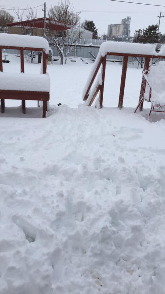
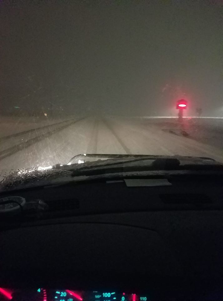
A fast moving cutoff low pressure system moved across the Panhandles on the night of January 27th into afternoon hours of the 28th. The center of the low cut through the southern Panhandles. Warm moist air from the gulf lead to some late evening thunderstorms to the east, while much colder air moved in from the northwest. Given the increased moisture to the Panhandles and the convective nature of the rain/snow showers, moderate to heavy precipitation was favored across the east and northern Panhandles. The southwest was influenced by wrap around moisture, but it was very limited, as the drier air would move in from the northwest and south to diminish the precipitation chances. This is why most of the southwest and south central Texas Panhandle only saw a few flurries and some freezing drizzle at best. Areas just west and north of Amarillo still managed to receive that wrap around precipitation and picked up some decent snow amounts. The slower progression of the low as it was exiting the Panhandles allowed for colder air to collide with the increased gulf moisture over the east and moderate to heavy snow impacted areas that were originally expected to see little to no snow accumulations. One of the big challenges with this system was the temperatures. So many areas were very close to that freezing mark, which posed a challenge to keep a consistent forecast for snow amounts. It's been seen in the past that it can snow above freezing, and when high snowfall rates occur, even with warm surface temperatures; it's just too much to overcome, and snow will accumulate. Strong winds also lead to snow drifts in the 1 to 2 foot range for several areas.
Snow/Ice
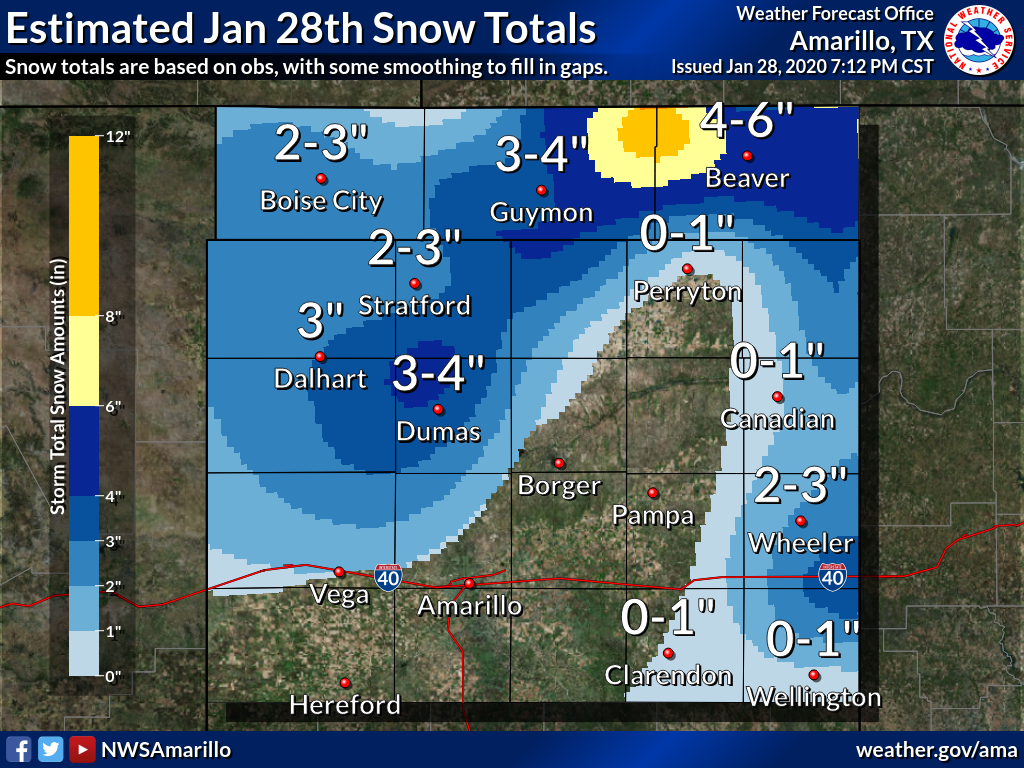
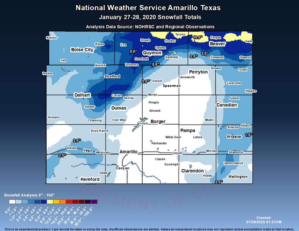
Snow estimate totals are based on observations and smoothing to fill in the vacant gaps. See storm reports for more accurate snow measurements at any given point.
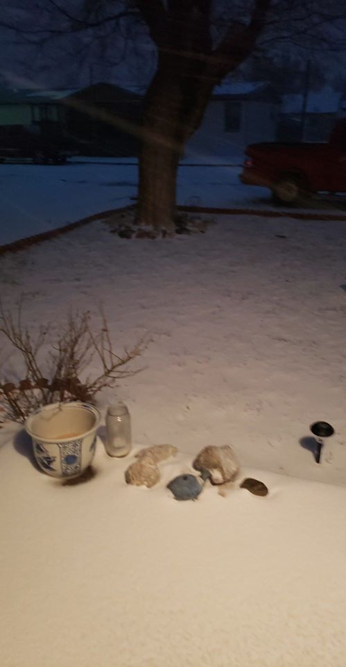
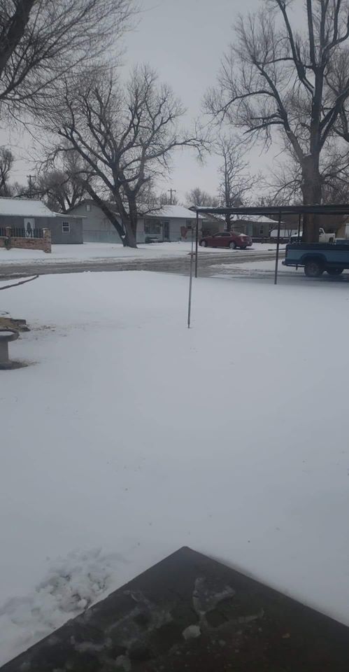
Photos & Video
Header
 |
 |
 |
 |
| Booker TX 1 Wrobyn Lovins |
Booker TX 2 Wrobyn Lovins |
Dumas TX Rebekah Garnett |
Guymon to Hardesty Garrett Mccargish |
Radar & Satellite
Radar loop from midnight through 4 PM January 28th. The area in red on satellite is the snow on the ground.
 |
 |
 |
 |
| 16 Hour Radar Loop | Satellite Image Snow on Ground | Visible Satellite of Snow on the Ground Morning of Jan 29th | Snow banding in the southeast Texas Panhandle. |
Storm Reports
..TIME...   ...EVENT...      ...CITY LOCATION...     ...LAT.LON...
..DATE...   ....MAG....      ..COUNTY LOCATION..ST.. ...SOURCE....
            ..REMARKS..

0417 AM     SNOW             CHANNING                35.68N 102.33W
01/28/2020  M1.5 INCH        HARTLEY            TX   SOCIAL MEDIA

            REPORT RECEIVED VIA TWITTER.

0529 AM     SNOW             FORGAN                  36.91N 100.54W
01/28/2020  E3.0 INCH        BEAVER             OK   SOCIAL MEDIA

            BLOWING SNOW IS ALSO CREATING NEAR ZERO VISIBILITY IN
            THE AREA.

0535 AM     SNOW             STRATFORD               36.34N 102.07W
01/28/2020  M2.0 INCH        SHERMAN            TX   LAW ENFORCEMENT

            BEEN SNOWING SINCE 1:30 AM, SNOW CONTINUES TO FALL WITH
            ICE PACKED ROADWAYS.

0548 AM     SNOW             GUYMON                  36.69N 101.48W
01/28/2020  E2.0 INCH        TEXAS              OK   LAW ENFORCEMENT

            LOCAL POLICE REPORTING AT LEAST 2 INCHES OF SNOW ON THE
            GROUND, WITH SNOW PACKED ROADWAYS.

0557 AM     SNOW             CHANNING                35.68N 102.33W
01/28/2020  M3.0 INCH        HARTLEY            TX   SOCIAL MEDIA

            TWITTER REPORT OF SNOW, WHICH IS STILL CONTINUING.

0558 AM     SNOW             10 W BOISE CITY         36.73N 102.69W
01/28/2020  M3.0 INCH        CIMARRON           OK   EMERGENCY MNGR

            SNOW HAS STOPPED FALLING, WITH 3 INCHES MEASURED.

0604 AM     SNOW             TEXLINE                 36.38N 103.02W
01/28/2020  M1.3 INCH        DALLAM             TX   TRAINED SPOTTER

0625 AM     SNOW             3 NW DUMAS              35.89N 102.00W
01/28/2020  E4.0 INCH        MOORE              TX   LAW ENFORCEMENT

            HEAVY SNOW STILL FALLING, MULTIPLE VEHICLES OFF ROADWAY
            DUE TO SLIPPERY ROADWAYS, BLOWING SNOW REDUCING
            VISIBILITY.

0630 AM     SNOW             DALHART                 36.06N 102.51W
01/28/2020  M2.0 INCH        DALLAM             TX   TRAINED SPOTTER

0641 AM     SNOW             FORGAN                  36.91N 100.54W
01/28/2020  M6.0 INCH        BEAVER             OK   LAW ENFORCEMENT

            LAW ENFORCEMENT IS REPORTING HALF A FOOT OF SNOW IN
            FORGAN, OK WITH DRIFTING. HEAVY SNOW AND LOW VISIBILITY
            CONTINUES.

0642 AM     SNOW             TURPIN                  36.87N 100.88W
01/28/2020  E7.0 INCH        BEAVER             OK   LAW ENFORCEMENT

            BEAVER COUNTY SHERIFF`S OFFICE IS REPORTING 7 INCHES OF
            SNOW WITH DRIFTS UP TO A FOOT IN TURPIN, OK. BLOWING
            SNOW, HEAVY AT TIMES, WITH REDUCED VISIBILITY CONTINUES.

0703 AM     SNOW             VEGA                    35.25N 102.43W
01/28/2020  M1.5 INCH        OLDHAM             TX   LAW ENFORCEMENT

            BLOWING SNOW CONTINUES WITH NEAR WHITEOUT CONDITIONS
            CONTINUING BETWEEN ADRIAN AND VEGA.

0725 AM     SNOW             MCLEAN                  35.23N 100.60W
01/28/2020  E1.0 INCH        GRAY               TX   DEPT OF HIGHWAYS

            TXDOT CREW REPORTED AT LEAST AN INCH OF SNOW ON THE
            GROUND AND PLOWING. HEAVY SNOW CONTINUED AT TIME OF
            REPORT.

0736 AM     SNOW             HOOKER                  36.86N 101.21W
01/28/2020  M7.0 INCH        TEXAS              OK   CO-OP OBSERVER

            SNOW STILL FALLING.

0737 AM     SNOW             6 W GRUVER              36.27N 101.51W
01/28/2020  E3.0 INCH        HANSFORD           TX   DEPT OF HIGHWAYS

            TXDOT CREW REPORTED 3 INCHES OF SNOW ALONG TEXAS
            HIGHWAY 15 WEST OF GRUVER.

0737 AM     SNOW             9 WSW HITCHLAND         36.47N 101.48W
01/28/2020  E5.0 INCH        HANSFORD           TX   DEPT OF HIGHWAYS

            TXDOT CREW REPORTED 5 INCHES OF SNOW WITH DRIFTING OVER
            ROADWAY ALONG TX HIGHWAY 136 NORTH OF GRUVER NEAR THE
            OKLAHOMA STATE LINE.

0756 AM     SNOW             GOODWELL                36.59N 101.63W
01/28/2020  M4.5 INCH        TEXAS              OK   PUBLIC

0757 AM     SNOW             DALHART                 36.06N 102.52W
01/28/2020  M3.0 INCH        DALLAM             TX   CO-OP OBSERVER

            BLOWING SNOW REPORTED

0808 AM     SNOW             BRYANS CORNER           36.62N 100.82W
01/28/2020  M2.0 INCH        BEAVER             OK   LAW ENFORCEMENT

            LAW ENFORCEMENT REPORTS 2 INCHES IN BRYAN`S CORNER.

0811 AM     SLEET            1 W PERRYTON            36.39N 100.82W
01/28/2020  M0.4 INCH        OCHILTREE          TX   CO-OP OBSERVER

0814 AM     SNOW             CANADIAN                35.91N 100.38W
01/28/2020  E1.0 INCH        HEMPHILL           TX   LAW ENFORCEMENT

            LAW ENFORCEMENT REPORTS INCH OF SNOW IN CANADIAN,
            MODERATE SNOW STILL FALLING.

0822 AM     SNOW             BOISE                   35.21N 102.86W
01/28/2020  M2.5 INCH        OLDHAM             TX   PUBLIC

            SNOW HAS SINCE ENDED.

0830 AM     SNOW             1 ENE CACTUS            36.05N 102.00W
01/28/2020  E5.0 INCH        MOORE              TX   LOCAL OFFICIAL

            SNOW STOPPED FALLING AT 8:30 AM, WITH 5 INCHES HAVING
            FALLEN. OFFICIALS AND STORM SPOTTERS REPORTED MULTIPLE
            SEMIS AND A BUS SLID OFF THE ROAD, SHUTTING DOWN U.S.
            HIGHWAY 287.

0905 AM     SNOW             12 N TEXHOMA            36.66N 101.81W
01/28/2020  M5.0 INCH        TEXAS              OK   TRAINED SPOTTER

            LIGHT SNOW WAS STILL FALLING.

0915 AM     SNOW             2 E LELA                35.22N 100.30W
01/28/2020  M1.5 INCH        WHEELER            TX   SOCIAL MEDIA

            SNOW WAS STILL FALLING.

0917 AM     SNOW             BEAVER                  36.81N 100.52W
01/28/2020  M3.0 INCH        BEAVER             OK   EMERGENCY MNGR

            EMERGENCY MANAGER MEASURED 3 INCHES OF SNOW IN BEAVER.

0954 AM     HEAVY SNOW       TURPIN                  36.87N 100.88W
01/28/2020  E10.0 INCH       BEAVER             OK   EMERGENCY MNGR

1111 AM     SNOW             GATE                    36.85N 100.06W
01/28/2020  M5.0 INCH        BEAVER             OK   EMERGENCY MNGR

1112 AM     SNOW             1 N BEAVER              36.83N 100.52W
01/28/2020  M5.0 INCH        BEAVER             OK   EMERGENCY MNGR

            JUST NORTH OF BEAVER.

1225 PM     SNOW             BRISCOE                 35.58N 100.29W
01/28/2020  E2.5 INCH        WHEELER            TX   TRAINED SPOTTER

            LIGHT SNOW FALLING AT TIME OF REPORT.

1233 PM     SNOW             2 N KELTON              35.43N 100.11W
01/28/2020  E1.5 INCH        WHEELER            TX   TRAINED SPOTTER

            SNOW HAD ENDED SHORTLY BEFORE CALL.

0105 PM     SNOW             SHAMROCK                35.22N 100.25W
01/28/2020  E4.5 INCH        WHEELER            TX   TRAINED SPOTTER

            LIGHT SNOW AT TIME OF REPORT. CAR CRASHES REPORTED
            ALONG HIGHWAY 83 NORTH OF SHAMROCK WITH POOR ROAD
            CONDITIONS.

0130 PM     SNOW             SLAPOUT                 36.62N 100.12W
01/28/2020  M5.0 INCH        BEAVER             OK   EMERGENCY MNGR

            STORM TOTAL SNOW

0130 PM     SNOW             BALKO                   36.63N 100.68W
01/28/2020  M3.0 INCH        BEAVER             OK   EMERGENCY MNGR

            STORM TOTAL SNOW

0130 PM     HEAVY SNOW       GATE                    36.85N 100.06W
01/28/2020  M6.0 INCH        BEAVER             OK   EMERGENCY MNGR

            STORM TOTAL SNOWFALL.

0130 PM     SNOW             ELMWOOD                 36.62N 100.52W
01/28/2020  M3.0 INCH        BEAVER             OK   EMERGENCY MNGR

            STORM TOTAL SNOW.

0143 PM     SNOW             4 SSE GILES             34.76N 100.57W
01/28/2020  E2.0 INCH        DONLEY             TX   DEPT OF HIGHWAYS

            AROUND 2 INCHES ALONG HIGHWAY 287 FROM HEDLEY TO
            MEMPHIS.
 |
Media use of NWS Web News Stories is encouraged! Please acknowledge the NWS as the source of any news information accessed from this site. |
|

