
Extreme heat continues today from the central Plains to the lower Mississippi River Valley, over southeast Montana, and from southern California into the Southwest Deserts. Extreme Heat Warnings remain in effect. Severe thunderstorms capable of strong to severe wind gusts and large hail are possible across the Great Lakes into the Ohio Valley today into tonight. Read More >
Overview
An upper level low ejected over the Central Plains Wednesday as a closed surface low rapidly intensified over the eastern parts of Colorado. The 971 mb low centered over southeastern Colorado and southwestern Kansas with impressive height rises on the back side and tight pressure gradients at all levels drove widespread strong winds to the surface across the Panhandles. Sustained winds of 40+ mph were verified across the Texas and Oklahoma Panhandles with the highest sustained wind of 67 mph measured by the West Texas Mesonet site 7 miles south southeast of Amarillo, Texas at 3:02 PM CDT. Winds gusts across the Panhandles reached 60+ mph with the highest wind gust of 84 mph measured by the West Texas Mesonet site 1 mile west northwest of Fritch, Texas at 12:28 PM CDT. The Amarillo International Airport received a peak sustained wind of 64 mph at 1:27 PM CDT and a peak gust of 80 mph at 1:20 PM CDT. Widespread wind damage was reported across the Texas and Oklahoma Panhandles including, but not limited to, multiple overturned semi trucks, uprooted trees, downed power lines, roofs blown off, building damage, and displaced objects such as trampolines. Multiple road closures and delays along with power outages occurred due to downed power lines and overturned semi trucks as very strong crosswinds caused travel difficulties for high profile vehicles.
Damage Map
Highest Wind Gusts
..TIME... ...EVENT... ...CITY LOCATION... ...LAT.LON...
..DATE... ....MAG.... ..COUNTY LOCATION..ST.. ...SOURCE....
..REMARKS..
1228 PM NON-TSTM WND GST 1 WNW FRITCH 35.65N 101.62W
03/13/2019 M84 MPH HUTCHINSON TX MESONET
0313 PM NON-TSTM WND GST 11 WNW BOOTLEG 34.89N 102.99W
03/13/2019 M81 MPH DEAF SMITH TX MESONET
0219 PM NON-TSTM WND GST BUSHLAND 35.19N 102.06W
03/13/2019 M81 MPH POTTER TX TRAINED SPOTTER
REPORT RECEIVED VIA SPOTTER NETWORK.
0120 PM NON-TSTM WND GST 6 ENE AMARILLO 35.22N 101.72W
03/13/2019 M80 MPH POTTER TX ASOS
0212 PM NON-TSTM WND GST 15 NNW AMARILLO 35.42N 101.93W
03/13/2019 M80 MPH POTTER TX MESONET
0232 PM NON-TSTM WND GST 12 SW CLAUDE 34.98N 101.50W
03/13/2019 M80 MPH ARMSTRONG TX MESONET
1240 PM NON-TSTM WND GST 6 WSW ADRIAN 35.25N 102.76W
03/13/2019 M79 MPH OLDHAM TX MESONET
0302 PM NON-TSTM WND GST 9 N AMARILLO 35.34N 101.81W
03/13/2019 M78 MPH POTTER TX MESONET
0120 PM NON-TSTM WND GST 2 WNW HEREFORD 34.83N 102.43W
03/13/2019 M78 MPH DEAF SMITH TX MESONET
0142 PM NON-TSTM WND GST 1 NW PALO DURO RESERVOI 36.36N 101.18W
03/13/2019 M78 MPH HANSFORD TX MESONET
0109 PM NON-TSTM WND GST 11 SSW ROMERO 35.57N 102.96W
03/13/2019 M78 MPH OLDHAM TX MESONET
0135 PM NON-TSTM WND GST 3 W DUMAS 35.86N 102.01W
03/13/2019 M77 MPH MOORE TX AWOS
0217 PM NON-TSTM WND GST 1 NNW STINNETT 35.84N 101.45W
03/13/2019 M77 MPH HUTCHINSON TX MESONET
1215 PM NON-TSTM WND GST 1 WSW BOYS RANCH 35.53N 102.27W
03/13/2019 M76 MPH OLDHAM TX MESONET
0143 PM NON-TSTM WND GST 1 SSW PANHANDLE 35.33N 101.39W
03/13/2019 M76 MPH CARSON TX MESONET
0302 PM NON-TSTM WND GST 7 SSE AMARILLO 35.11N 101.80W
03/13/2019 M75 MPH RANDALL TX MESONET
0234 PM NON-TSTM WND GST 2 NW LAKE MCCLELLAN 35.23N 100.90W
03/13/2019 M75 MPH GRAY TX MESONET
0253 PM NON-TSTM WND GST 2 N BORGER 35.70N 101.40W
03/13/2019 M74 MPH HUTCHINSON TX ASOS
0252 PM NON-TSTM WND GST 6 E CANADIAN 35.92N 100.28W
03/13/2019 M73 MPH HEMPHILL TX MESONET
1105 AM NON-TSTM WND GST 3 SW DALHART 36.03N 102.55W
03/13/2019 M73 MPH HARTLEY TX ASOS
0357 PM NON-TSTM WND GST GOODNIGHT 35.03N 101.19W
03/13/2019 M73 MPH ARMSTRONG TX MESONET
0417 PM NON-TSTM WND GST 4 E PALO DURO (JA) 34.82N 101.12W
03/13/2019 M72 MPH ARMSTRONG TX MESONET
0315 PM NON-TSTM WND GST 5 NNW PAMPA 35.61N 101.00W
03/13/2019 M72 MPH GRAY TX AWOS
0326 PM NON-TSTM WND GST 3 NNE UMBARGER 34.99N 102.08W
03/13/2019 M72 MPH RANDALL TX MESONET
0425 PM NON-TSTM WND GST 1 ENE MCLEAN 35.24N 100.57W
03/13/2019 M71 MPH GRAY TX MESONET
0303 PM NON-TSTM WND GST BOOTLEG 34.83N 102.81W
03/13/2019 M70 MPH DEAF SMITH TX MESONET
BOOTLEG RAWS.
0315 PM NON-TSTM WND GST 26 NW MIAMI 35.96N 100.97W
03/13/2019 M70 MPH ROBERTS TX AWOS
0237 PM NON-TSTM WND GST 3 W DOZIER 35.08N 100.39W
03/13/2019 M69 MPH COLLINGSWORTH TX MESONET
1127 AM NON-TSTM WND GST 2 W GUYMON 36.69N 101.51W
03/13/2019 M69 MPH TEXAS OK ASOS
1255 PM NON-TSTM WND GST 5 ENE HEREFORD 34.86N 102.33W
03/13/2019 M69 MPH DEAF SMITH TX AWOS
0327 PM NON-TSTM WND GST 1 WNW HEREFORD 34.83N 102.41W
03/13/2019 M68 MPH DEAF SMITH TX MESONET
CWOP STATION EW9322.
0231 PM NON-TSTM WND GST 3 NNW PALO DURO CANYON 34.99N 101.69W
03/13/2019 M68 MPH RANDALL TX MESONET
0235 PM NON-TSTM WND GST 3 ENE PERRYTON 36.41N 100.75W
03/13/2019 M68 MPH OCHILTREE TX AWOS
0450 PM NON-TSTM WND GST 2 WSW CLARENDON 34.92N 100.93W
03/13/2019 M67 MPH DONLEY TX MESONET
0332 PM NON-TSTM WND GST 2 ENE HEREFORD 34.83N 102.36W
03/13/2019 M67 MPH DEAF SMITH TX MESONET
CWOP STATION EW9652.
1230 PM NON-TSTM WND GST 1 SSW BEAVER 36.80N 100.53W
03/13/2019 M66 MPH BEAVER OK MESONET
1150 AM NON-TSTM WND GST 2 E GOODWELL 36.60N 101.60W
03/13/2019 M66 MPH TEXAS OK MESONET
0205 PM NON-TSTM WND GST 2 E PAMPA 35.54N 100.93W
03/13/2019 M66 MPH GRAY TX MESONET
0115 PM NON-TSTM WND GST 13 SSW PERICO 36.11N 102.97W
03/13/2019 M66 MPH DALLAM TX MESONET
CWOP STATION FW0609.
0255 PM NON-TSTM WND GST 8 W SLAPOUT 36.60N 100.26W
03/13/2019 M65 MPH BEAVER OK MESONET
1050 AM NON-TSTM WND GST 5 WSW WARE 36.15N 102.78W
03/13/2019 M65 MPH DALLAM TX MESONET
CWOP STATION FW2804.
0452 PM NON-TSTM WND GST 4 E WHEELER 35.45N 100.20W
03/13/2019 M65 MPH WHEELER TX MESONET
WHEELER RAWS.
1120 AM NON-TSTM WND GST 1 W HOOKER 36.86N 101.23W
03/13/2019 M64 MPH TEXAS OK MESONET
0235 PM NON-TSTM WND GST 2 WSW SANFORD 35.69N 101.57W
03/13/2019 M64 MPH HUTCHINSON TX MESONET
CEDAR RAWS.
0550 PM NON-TSTM WND GST 12 NE EVA 36.92N 101.78W
03/13/2019 M62 MPH TEXAS OK MESONET
0155 PM NON-TSTM WND GST 2 SW CANADIAN 35.89N 100.40W
03/13/2019 M61 MPH HEMPHILL TX AWOS
0203 PM NON-TSTM WND GST PALO DURO CANYON 34.94N 101.64W
03/13/2019 M60 MPH RANDALL TX MESONET
0352 PM NON-TSTM WND GST WHEELER 35.44N 100.28W
03/13/2019 M60 MPH WHEELER TX MESONET
WHEELER RAWS SITE REPORTED 60 MPH WIND GUST.
0101 PM NON-TSTM WND GST 1 SSW HEREFORD 34.82N 102.40W
03/13/2019 M58 MPH DEAF SMITH TX MESONET
CWOP STATION EW9717.
Highest Sustained Winds
..TIME... ...EVENT... ...CITY LOCATION... ...LAT.LON...
..DATE... ....MAG.... ..COUNTY LOCATION..ST.. ...SOURCE....
..REMARKS..
0302 PM HIGH SUST WINDS 7 SSE AMARILLO 35.11N 101.80W
03/13/2019 M67 MPH RANDALL TX MESONET
1158 AM HIGH SUST WINDS 15 NNW AMARILLO 35.42N 101.93W
03/13/2019 M66 MPH POTTER TX MESONET
0313 PM HIGH SUST WINDS 11 WNW BOOTLEG 34.89N 102.99W
03/13/2019 M66 MPH DEAF SMITH TX MESONET
1241 PM HIGH SUST WINDS 11 SSW ROMERO 35.57N 102.96W
03/13/2019 M66 MPH OLDHAM TX MESONET
0142 PM HIGH SUST WINDS 1 NW PALO DURO RESERVOI 36.36N 101.18W
03/13/2019 M65 MPH HANSFORD TX MESONET
0129 PM HIGH SUST WINDS 1 SSW PANHANDLE 35.33N 101.39W
03/13/2019 M65 MPH CARSON TX MESONET
1235 PM HIGH SUST WINDS 6 WSW ADRIAN 35.25N 102.76W
03/13/2019 M64 MPH OLDHAM TX MESONET
0120 PM HIGH SUST WINDS 6 ENE AMARILLO 35.22N 101.72W
03/13/2019 M64 MPH POTTER TX ASOS
0356 PM HIGH SUST WINDS GOODNIGHT 35.03N 101.19W
03/13/2019 M64 MPH ARMSTRONG TX MESONET
0234 PM HIGH SUST WINDS 2 NW LAKE MCCLELLAN 35.23N 100.90W
03/13/2019 M64 MPH GRAY TX MESONET
1253 PM HIGH SUST WINDS 1 WNW FRITCH 35.65N 101.62W
03/13/2019 M63 MPH HUTCHINSON TX MESONET
0217 PM HIGH SUST WINDS 1 NNW STINNETT 35.84N 101.45W
03/13/2019 M63 MPH HUTCHINSON TX MESONET
0245 PM HIGH SUST WINDS 9 N AMARILLO 35.34N 101.81W
03/13/2019 M61 MPH POTTER TX MESONET
0252 PM HIGH SUST WINDS 6 E CANADIAN 35.92N 100.28W
03/13/2019 M61 MPH HEMPHILL TX MESONET
0215 PM HIGH SUST WINDS 3 W DUMAS 35.86N 102.01W
03/13/2019 M61 MPH MOORE TX AWOS
0358 PM HIGH SUST WINDS 3 NNE UMBARGER 34.99N 102.08W
03/13/2019 M60 MPH RANDALL TX MESONET
1209 PM HIGH SUST WINDS 3 SW DALHART 36.03N 102.55W
03/13/2019 M59 MPH HARTLEY TX ASOS
0438 PM HIGH SUST WINDS 4 E PALO DURO (JA) 34.82N 101.12W
03/13/2019 M58 MPH ARMSTRONG TX MESONET
0235 PM HIGH SUST WINDS 5 NNW PAMPA 35.61N 101.00W
03/13/2019 M58 MPH GRAY TX AWOS
1151 AM HIGH SUST WINDS 1 WSW BOYS RANCH 35.53N 102.27W
03/13/2019 M57 MPH OLDHAM TX MESONET
1125 AM HIGH SUST WINDS 2 W GUYMON 36.69N 101.51W
03/13/2019 M56 MPH TEXAS OK ASOS
1245 PM HIGH SUST WINDS 2 WNW HEREFORD 34.83N 102.43W
03/13/2019 M56 MPH DEAF SMITH TX MESONET
0155 PM HIGH SUST WINDS 26 NW MIAMI 35.96N 100.97W
03/13/2019 M55 MPH ROBERTS TX AWOS
0454 PM HIGH SUST WINDS 12 SW CLAUDE 34.98N 101.50W
03/13/2019 M54 MPH ARMSTRONG TX MESONET
0407 PM HIGH SUST WINDS 3 W DOZIER 35.08N 100.39W
03/13/2019 M54 MPH COLLINGSWORTH TX MESONET
0225 PM HIGH SUST WINDS 1 ENE MCLEAN 35.24N 100.57W
03/13/2019 M53 MPH GRAY TX MESONET
0355 PM HIGH SUST WINDS 5 ENE HEREFORD 34.86N 102.33W
03/13/2019 M52 MPH DEAF SMITH TX AWOS
1045 AM HIGH SUST WINDS 2 E GOODWELL 36.60N 101.60W
03/13/2019 M51 MPH TEXAS OK MESONET
1217 PM HIGH SUST WINDS 3 NNW PALO DURO CANYON 34.99N 101.69W
03/13/2019 M51 MPH RANDALL TX MESONET
0135 PM HIGH SUST WINDS 3 ENE PERRYTON 36.41N 100.75W
03/13/2019 M51 MPH OCHILTREE TX AWOS
0100 PM HIGH SUST WINDS 5 WSW WARE 36.15N 102.78W
03/13/2019 M51 MPH DALLAM TX MESONET
CWOP STATION FW2804.
0255 PM HIGH SUST WINDS 2 WSW CLARENDON 34.92N 100.93W
03/13/2019 M50 MPH DONLEY TX MESONET
1155 AM HIGH SUST WINDS 1 W HOOKER 36.86N 101.23W
03/13/2019 M50 MPH TEXAS OK MESONET
1245 PM HIGH SUST WINDS 13 SSW PERICO 36.11N 102.97W
03/13/2019 M50 MPH DALLAM TX MESONET
CWOP STATION FW0609.
0255 PM HIGH SUST WINDS 8 W SLAPOUT 36.60N 100.26W
03/13/2019 M49 MPH BEAVER OK MESONET
1225 PM HIGH SUST WINDS 1 SSW BEAVER 36.80N 100.53W
03/13/2019 M48 MPH BEAVER OK MESONET
0525 PM HIGH SUST WINDS 3 SSE BOISE CITY 36.69N 102.50W
03/13/2019 M48 MPH CIMARRON OK MESONET
1203 PM HIGH SUST WINDS BOOTLEG 34.83N 102.81W
03/13/2019 M48 MPH DEAF SMITH TX MESONET
BOOTLEG RAWS.
0253 PM HIGH SUST WINDS 2 N BORGER 35.70N 101.40W
03/13/2019 M48 MPH HUTCHINSON TX ASOS
0540 PM HIGH SUST WINDS 12 NE EVA 36.92N 101.78W
03/13/2019 M47 MPH TEXAS OK MESONET
0235 PM HIGH SUST WINDS 2 SW CANADIAN 35.89N 100.40W
03/13/2019 M46 MPH HEMPHILL TX AWOS
0445 PM HIGH SUST WINDS 2 E PAMPA 35.54N 100.93W
03/13/2019 M45 MPH GRAY TX MESONET
0135 PM HIGH SUST WINDS 2 WSW SANFORD 35.69N 101.57W
03/13/2019 M42 MPH HUTCHINSON TX MESONET
CEDAR RAWS.
0452 PM HIGH SUST WINDS 4 E WHEELER 35.45N 100.20W
03/13/2019 M42 MPH WHEELER TX MESONET
WHEELER RAWS.
Photos & Video
 |
 |
 |
 |
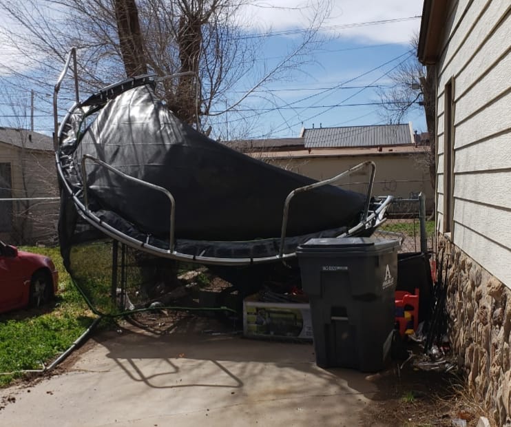
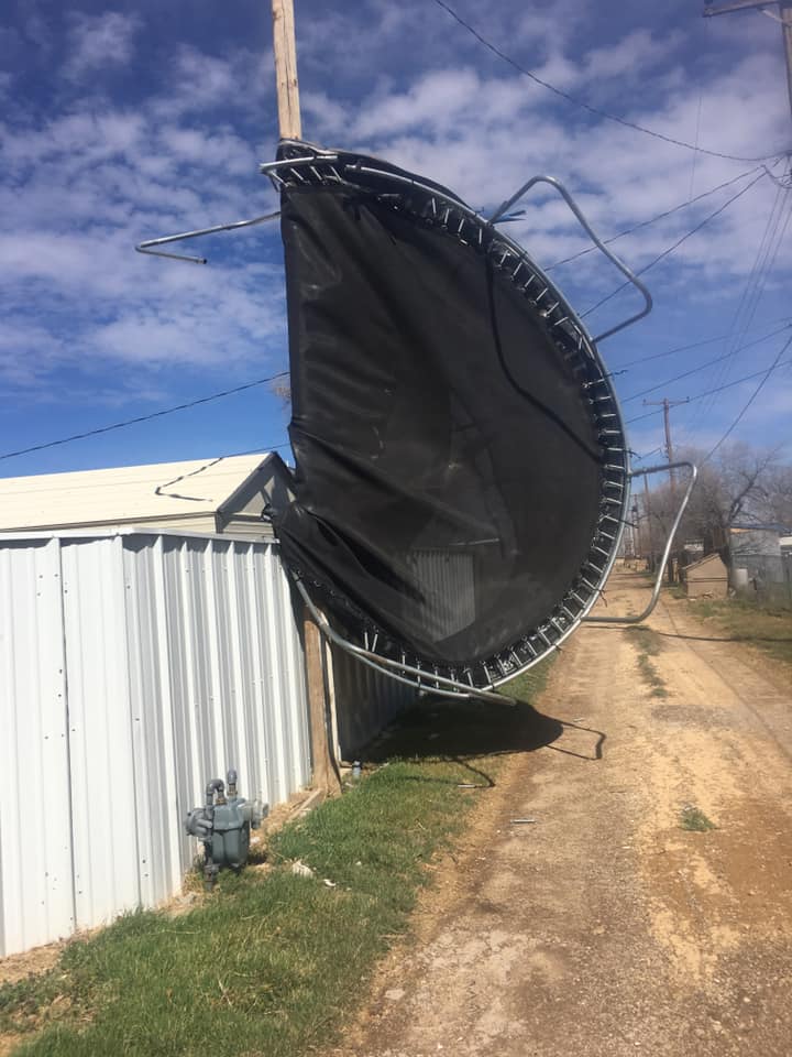
| Destroyed trampoline in Amarillo (Beatrice Cantu) |
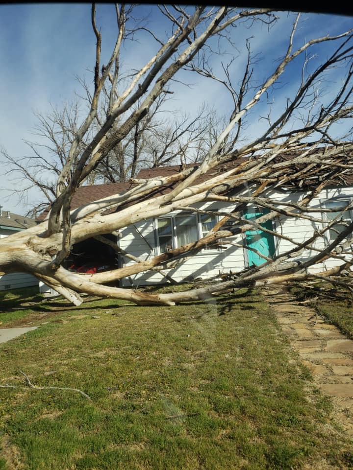
Treehouse destroyed in central Amarillo (Brittainy Crafton) |
Tree on house in central Amarillo (Brittainy Crafton) |
Tree on house in central Amarillo (Brittainy Crafton) |
 |
 |
 |
 |
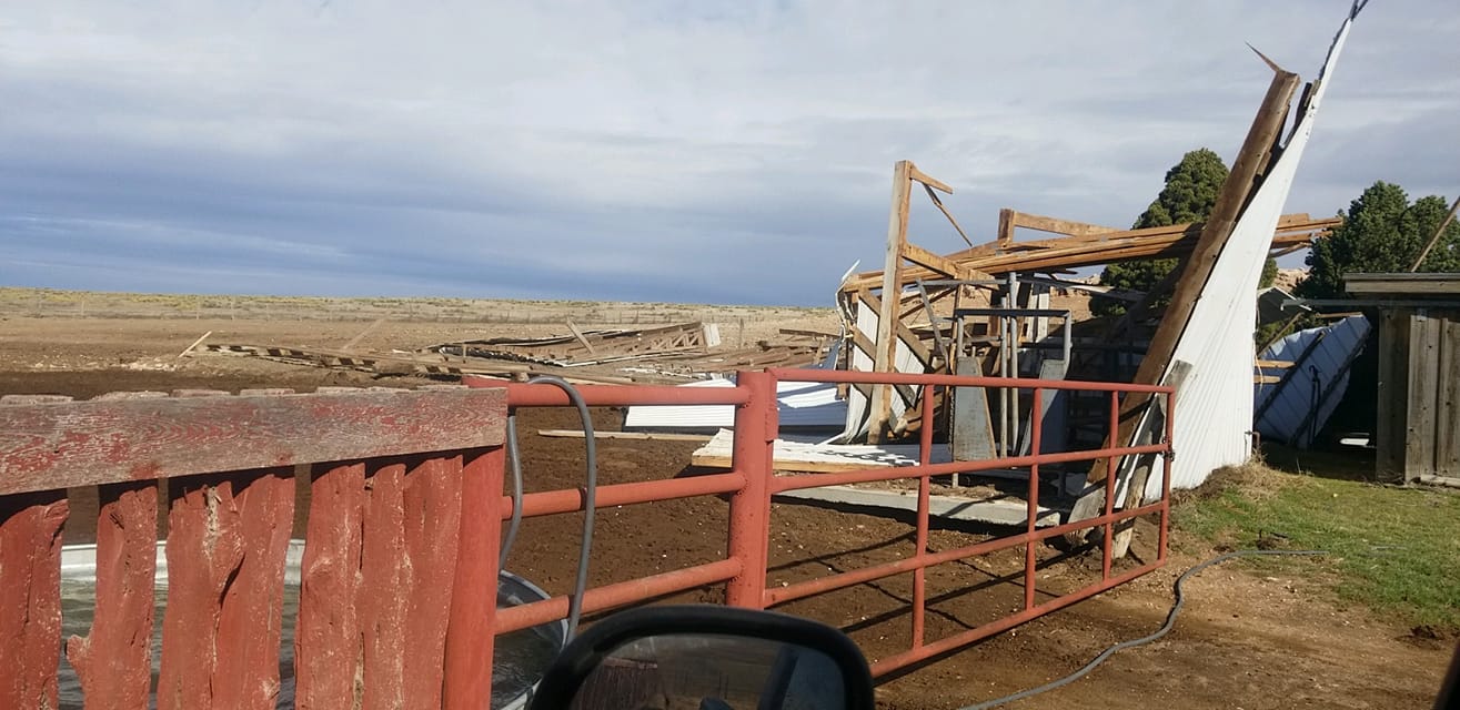
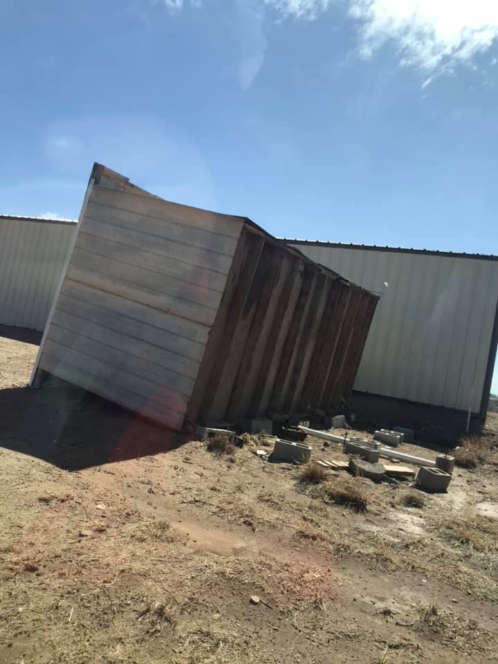
| Barn destroyed in Texhoma (Caleb Clinesmith) |
Damaged building in Hardesty (Clayton Frantz) |
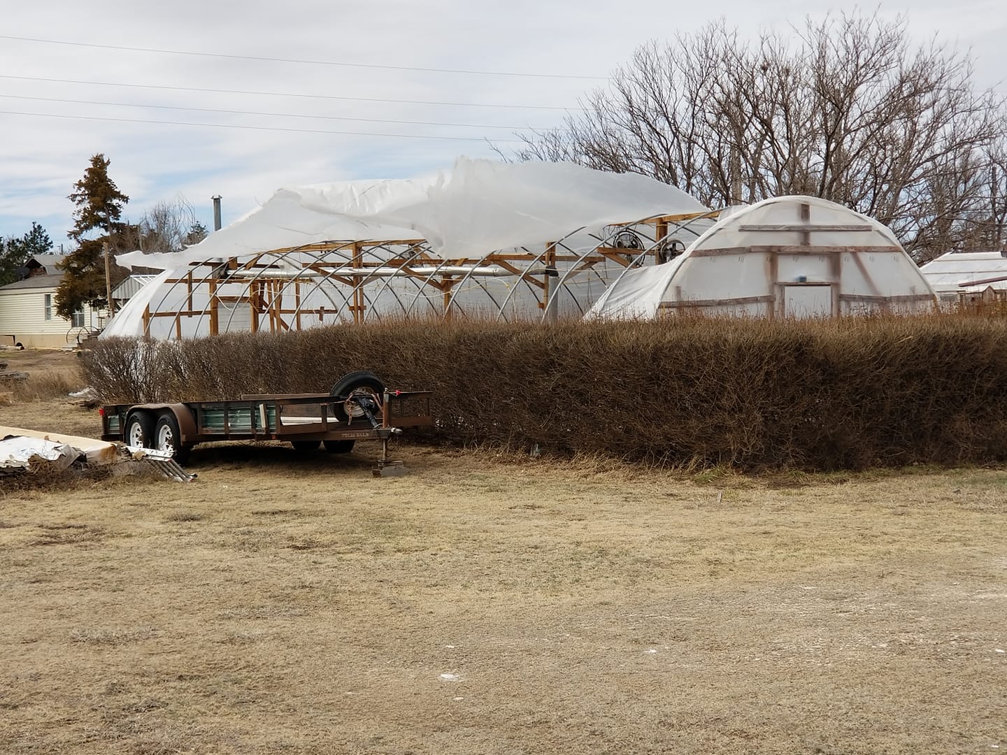
Damaged greenhouse in Hardesty (Clayton Frantz) |
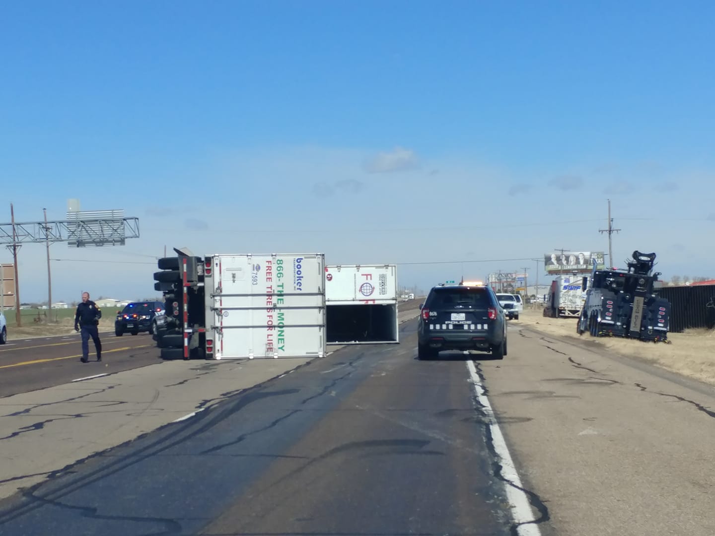
Semi overturned in Amarillo (Jay McCoy) |
 |
 |
 |
 |
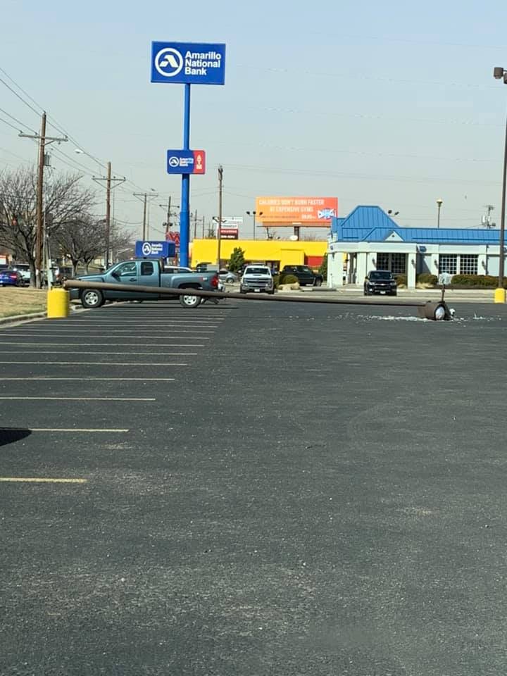
| Downed lightpole in Amarillo (Josh Fredlund) |
Mangled trampoline in Amarillo (Koko Aung) |
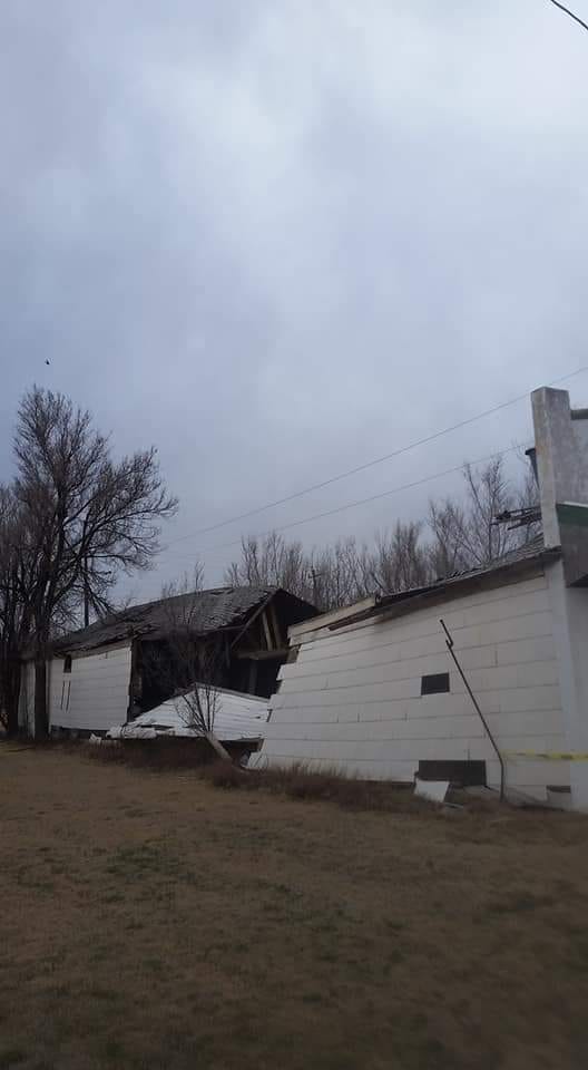
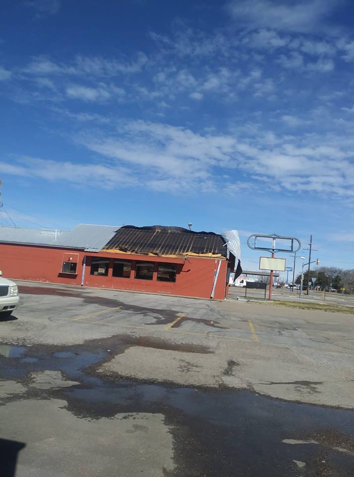
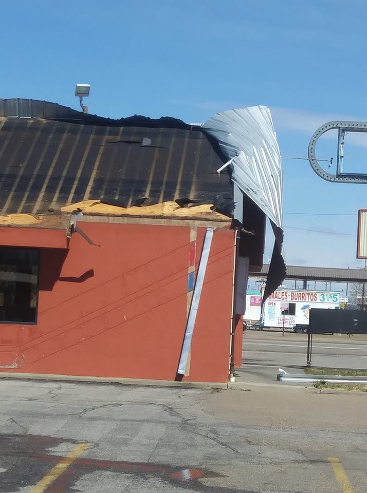
Damaged roof at SE 27th Avenue and Grand in Amarillo (Kole Thompson) |
Damaged roof at SE 27th Avenue and Grand in Amarillo (Kole Thompson) |
 |
 |
 |
 |
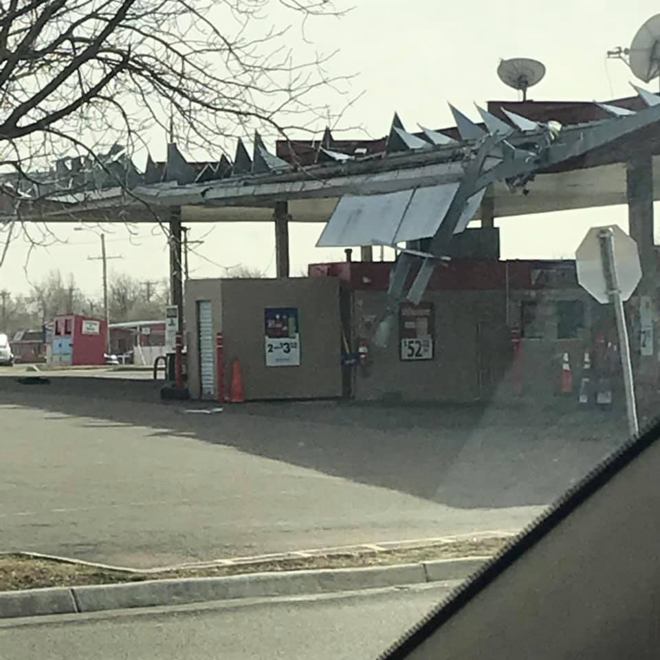
| Heavily damaged gas station canopy in Amarillo (Meagan Roberson) |
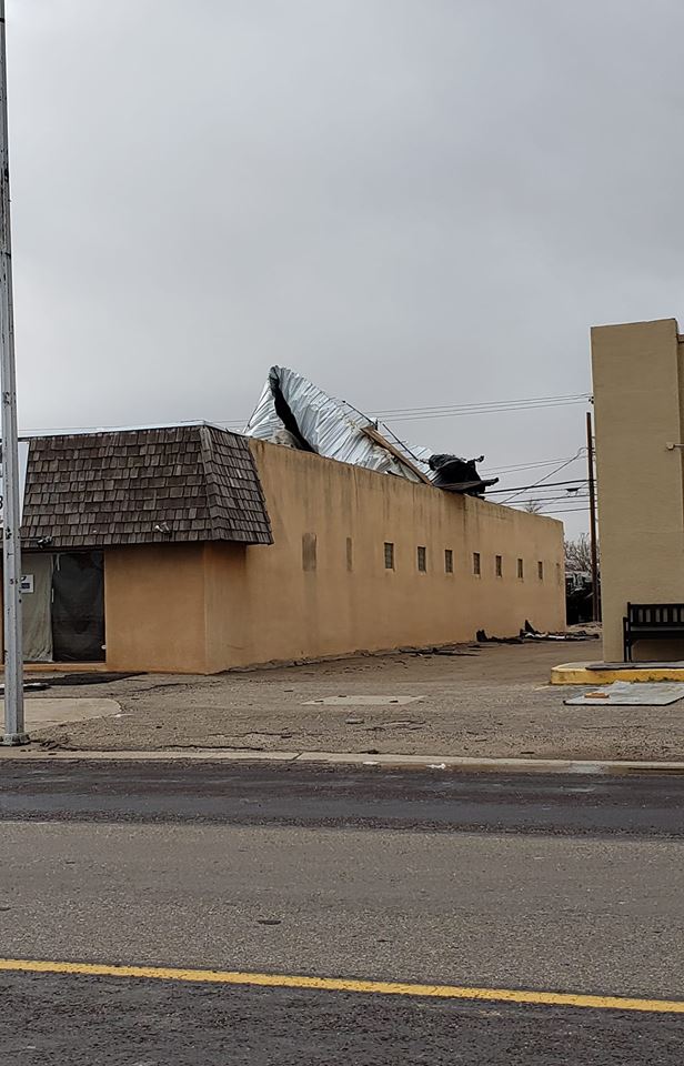
Damaged roof in Pampa (Outta Here Travels) |
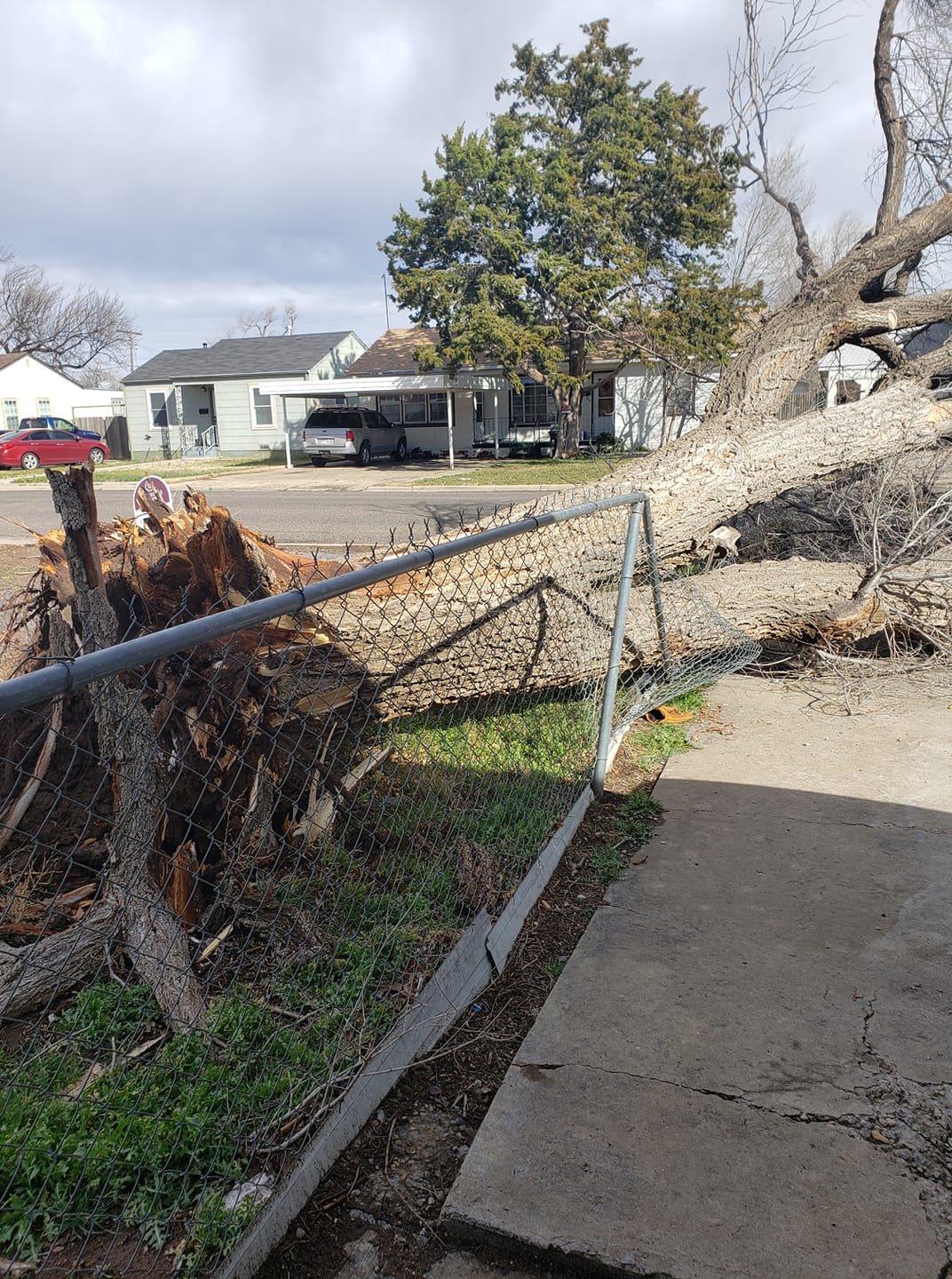
Tree downed onto fence in northeast Amarillo (Paty Galaviz) |
Outbuilding flipped in Amarillo (Pelon Coyame) |
 |
 |
 |
 |
| Semi truck flipped over in Amarillo (Pelon Coyame) |
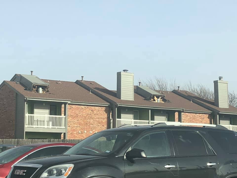
Chimneys knocked over at an apartment complex in Amarillo (Taryn Trason) |
Broken storefront windows in Amarillo (Trisha Davis) |
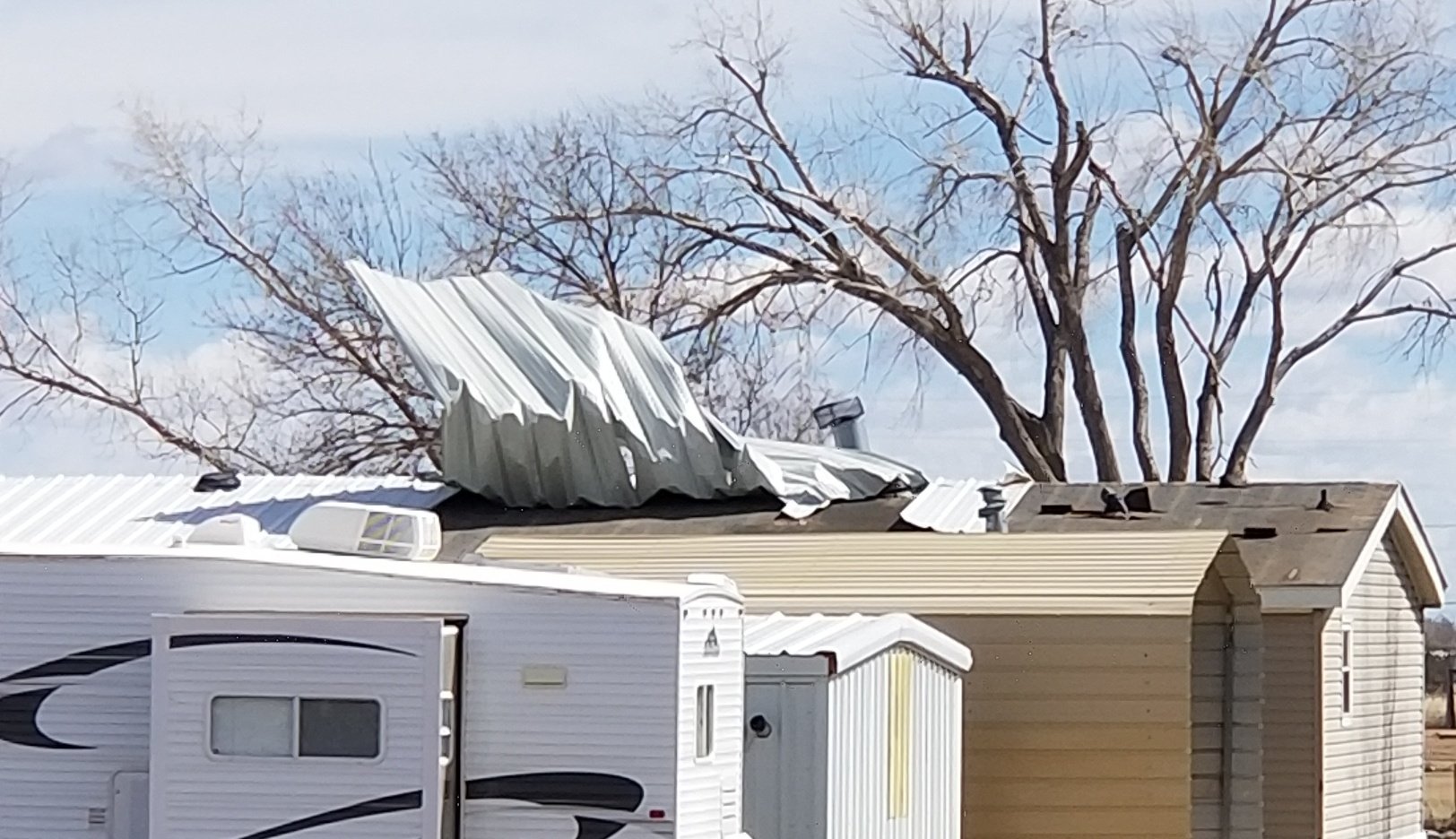
Roof damage in Dumas (Xitaly Wiesman) |
Wind Damage Reports
..TIME... ...EVENT... ...CITY LOCATION... ...LAT.LON...
..DATE... ....MAG.... ..COUNTY LOCATION..ST.. ...SOURCE....
..REMARKS..
1107 AM NON-TSTM WND DMG 5 W AMARILLO 35.19N 101.92W
03/13/2019 POTTER TX EMERGENCY MNGR
POWER LINES DOWN IN MEDI-PARK AREA.
1110 AM NON-TSTM WND DMG 4 W AMARILLO 35.19N 101.90W
03/13/2019 POTTER TX EMERGENCY MNGR
POWER LINES DOWN ON INTERSTATE 40 FRONTAGE
ROAD AND CHERRY STREET.
1121 AM NON-TSTM WND DMG 2 E CANYON 34.98N 101.88W
03/13/2019 RANDALL TX DEPT OF HIGHWAYS
MULTIPLE OVERTURNED SEMI TRUCKS AT
INTERSTATE 27 AND TEXAS HIGHWAY 217.
1127 AM NON-TSTM WND DMG 5 S CANADIAN 35.84N 100.38W
03/13/2019 HEMPHILL TX DEPT OF HIGHWAYS
OVERTURNED SEMI TRUCK BLOCKING US HIGHWAY 87
SOUTH.
1129 AM NON-TSTM WND DMG AMARILLO 35.20N 101.81W
03/13/2019 POTTER TX EMERGENCY MNGR
DOWNED POWER LINES IN THE AREA.
1134 AM NON-TSTM WND DMG 6 SW AMARILLO 35.15N 101.90W
03/13/2019 RANDALL TX EMERGENCY MNGR
DOWNED POWER LINES NEAR HILLSIDE AND BELL.
1158 AM NON-TSTM WND DMG 4 ESE CANYON 34.95N 101.86W
03/13/2019 RANDALL TX EMERGENCY MNGR
EMERGENCY MANAGEMENT REPORTS AN 18 WHEELER
BLOWN OVER ON INTERSTATE 27 NEAR MILE MARKER
105.
1211 PM NON-TSTM WND DMG 4 WSW AMARILLO 35.17N 101.89W
03/13/2019 RANDALL TX FIRE DEPT/RESCUE
POWER LINES ARE DOWN IN THE AREA OF 36TH ST
AND NEBRASKA.
1214 PM NON-TSTM WND DMG 1 SW BORGER 35.65N 101.41W
03/13/2019 HUTCHINSON TX EMERGENCY MNGR
EMERGENCY MANAGEMENT REPORTS STRUCTURE
DAMAGE IN BORGER. ONE NEW METAL BUILDING
COLLAPSED. CARPORTS, TREES, AND POWER LINES
BLOWN DOWN DUE TO THE WINDS.
1231 PM NON-TSTM WND DMG 4 E AMARILLO 35.19N 101.74W
03/13/2019 POTTER TX EMERGENCY MNGR
SEMI-TRUCK ROLLED OVER DUE TO WIND NEAR I-40
AND LOOP 335 (LAKESIDE).
1233 PM NON-TSTM WND DMG 3 WNW AMARILLO 35.22N 101.87W
03/13/2019 POTTER TX EMERGENCY MNGR
POWERLINES DOWN NEAR THE INTERSECTION OF
10TH AND ALABAMA IN AMARILLO.
1239 PM NON-TSTM WND DMG 2 E AMARILLO 35.21N 101.78W
03/13/2019 POTTER TX EMERGENCY MNGR
TREES DOWNED IN THE AREA OF EASTERN AND SE
3RD.
1240 PM NON-TSTM WND DMG 3 NE AMARILLO 35.23N 101.79W
03/13/2019 POTTER TX TRAINED SPOTTER
LARGE TREE ACROSS ROADWAY AT BOLTON AND
15TH.
1241 PM NON-TSTM WND DMG 3 WSW AMARILLO 35.19N 101.88W
03/13/2019 POTTER TX TRAINED SPOTTER
REPORT RECEIVED OF ROOF BLOWN OFF STRUCTURE
NEAR INTERSTATE 40 AND PARAMOUNT BLVD.
1246 PM NON-TSTM WND DMG 4 SSW AMARILLO 35.14N 101.86W
03/13/2019 RANDALL TX PUBLIC
MULTIPLE REPORTS OF FENCES DOWN IN THE
FOXRIDGE NEIGHBORHOOD.
1248 PM NON-TSTM WND DMG 4 W AMARILLO 35.20N 101.89W
03/13/2019 POTTER TX EMERGENCY MNGR
POWER LINES DOWN IN THE AREA OF BEVERLY DR
AND SW 15TH AVE.
1251 PM NON-TSTM WND DMG 3 SSE STRATFORD 36.29N 102.05W
03/13/2019 SHERMAN TX DEPT OF HIGHWAYS
SEMI-TRUCK OVERTURNED ON US HIGHWAY 287,
BLOCKING SOUTHBOUND LANES.
0112 PM NON-TSTM WND DMG 1 S CANYON 34.97N 101.92W
03/13/2019 RANDALL TX EMERGENCY MNGR
POWER LINES DOWN NEAER CANYON HIGH SCHOOL.
GRASS FIRE STARTED BY POWER LINES WAS
QUICKLY CONTAINED.
0115 PM NON-TSTM WND DMG 3 W AMARILLO 35.21N 101.87W
03/13/2019 POTTER TX EMERGENCY MNGR
LARGE TREES DOWNED IN THE AREA OF SW 8TH AVE
AND S ALABAMA ST.
0115 PM NON-TSTM WND DMG 11 SSE MASTERSON 35.48N 101.89W
03/13/2019 POTTER TX DEPT OF HIGHWAYS
SEMI-TRUCK CARRYING CATTLE OVERTURNED.
0126 PM NON-TSTM WND DMG GROOM 35.20N 101.11W
03/13/2019 CARSON TX DEPT OF HIGHWAYS
TXDOT REPORTING TRACTOR TRAILER OVERTURNED
ON INTERSTATE 40 OVERPASS.
0144 PM NON-TSTM WND DMG 4 WSW AMARILLO 35.17N 101.89W
03/13/2019 RANDALL TX EMERGENCY MNGR
POWER LINES DOWN NEAR 36TH ST AND NEBRASKA
IN AMARILLO.
0147 PM NON-TSTM WND DMG 6 SW AMARILLO 35.13N 101.88W
03/13/2019 RANDALL TX EMERGENCY MNGR
REPORT RECEIVED OF POWERLINES SNAPPED IN
HALF NEAR ARDEN RD AND S WESTERN ST IN
AMARILLO.
0203 PM NON-TSTM WND DMG HEREFORD 34.82N 102.40W
03/13/2019 DEAF SMITH TX EMERGENCY MNGR
DAMAGE REPORTED IN THE CITY OF HEREFORD.
ROOFS BLOWN OFF A FEW BUILDINGS, POWER LINES
AND TREES DOWN.
0224 PM NON-TSTM WND DMG 7 E AMARILLO 35.22N 101.70W
03/13/2019 POTTER TX OTHER FEDERAL
ROOF DAMAGE REPORTED AT THE ARDEN BUILDING
IN THE RICK HUSBAND INTERNATIONAL AIRPORT
COMPLEX.
0245 PM NON-TSTM WND DMG 6 N AMARILLO 35.28N 101.83W
03/13/2019 POTTER TX EMERGENCY MNGR
ROOF BLOWN OFF STRUCTURE NEAR US HIGHWAY 287
AND WILLOW CREEK DR NORTH OF AMARILLO.
0246 PM NON-TSTM WND DMG AMARILLO 35.20N 101.82W
03/13/2019 POTTER TX UTILITY COMPANY
XCEL ENERGY REPORTS 8,389 CUSTOMERS WITHOUT
POWER DUE TO WINDS.
0250 PM NON-TSTM WND DMG 5 N TIMBERCREEK CANYON 35.12N 101.83W
03/13/2019 RANDALL TX FIRE DEPT/RESCUE
RANDALL COUNTY FIRE DEPARTMENT ON SOUTH LOOP
335 REPORTING ROOF DAMAGE.
0324 PM NON-TSTM WND DMG 7 WSW AMARILLO 35.18N 101.94W
03/13/2019 RANDALL TX EMERGENCY MNGR
DOWNED POWERLINES AT 34TH AND SONCY HAS
RESULTED IN THE CLOSURE OF SONCY BETWEEN
34TH AND 45TH.
0341 PM NON-TSTM WND DMG 4 E AMARILLO 35.20N 101.74W
03/13/2019 POTTER TX NWS EMPLOYEE
NWS EMPLOYEE REPORTS DOWNED SEMI-TRUCK AT
LOOP 335 (LAKESIDE) AND 3RD AVE.
0344 PM NON-TSTM WND DMG 10 N AMARILLO 35.35N 101.82W
03/13/2019 POTTER TX EMERGENCY MNGR
EM REPORTS A SEMI-TRUCK THAT ROLLED OVER DUE
TO WIND NORTH OF AMARILLO.
0403 PM NON-TSTM WND DMG 7 ENE AMARILLO 35.23N 101.71W
03/13/2019 POTTER TX OTHER FEDERAL
THE FAA IS EVACUATING THE AIRPORT TOWER DUE
TO SIDING COMING OFF THE BUILDING.
 |
Media use of NWS Web News Stories is encouraged! Please acknowledge the NWS as the source of any news information accessed from this site. |
|

