
In the Pacific Northwest into northern California, areas of heavy rain for the coastal ranges and heavy snowfall over the higher elevations of the Cascades are expected into Friday. Dry and windy conditions may produce elevated fire weather conditions in the central and southern High Plains and the Upper Midwest. Windy conditions and scattered rain and snow showers will continue in the Northeast. Read More >
Overview
A strong mid/upper level low moved across the Four Corners region. This low gradually shifted east-northeastward through the day. A couple of more subtle shortwaves ejected northeast ahead of the low, the first shortwave provided lift for a few thunderstorms in the morning across the Panhandles, and the second shortwave provided some lift by mid afternoon. Afternoon clearing in eastern NM helped surface heating and steepened low level lapse rates. As the second shortwave arrived, the combination of mid level lift and convergence along a weak moisture gradient supported additional thunderstorm development. Storm mode became quasi-linear fairly quickly with embedded supercells. Very good 0-1km and 0-3km helicity values supported rotating storms and low level rotation supporting the potential for tornadoes. Low level moisture advection was strong, however the best surface moisture stalled. Surface dewpoints ultimately maxed out in the upper 40s for most locations in the Panhandles which was a mitigating factor for tornadoes. That being said, several storms developed with hail that ranged from accumulating small hail, up to as large as baseball sized hail which was supported by very cold mid level temperatures and strong deep layer shear. Very few wind reports came out of this storm, but there were a couple gusts around 60 mph. Several funnel clouds and two brief tornadoes have been confirmed with no reports of damage so far. One tornado was 8 miles southeast of Wilco in Hartley County, and the second was 9 miles southwest of Cactus in Moore County.
Photos & Video
 |
.png) |
 |
 |
|
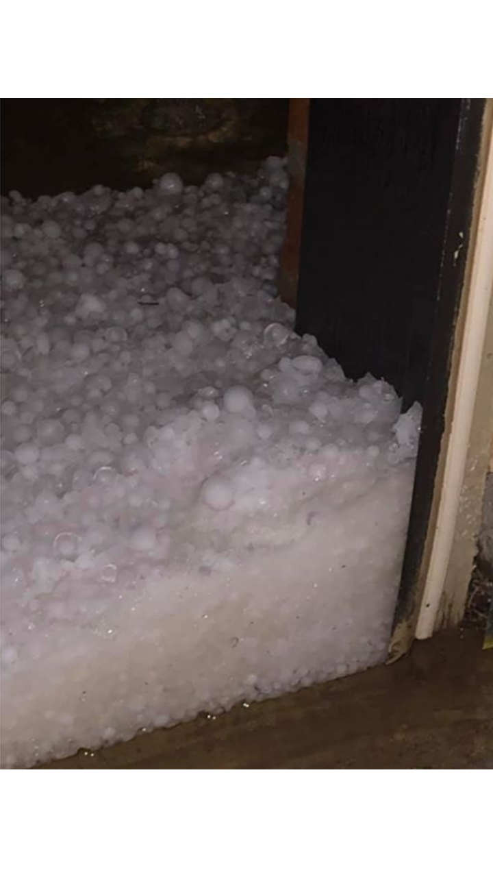
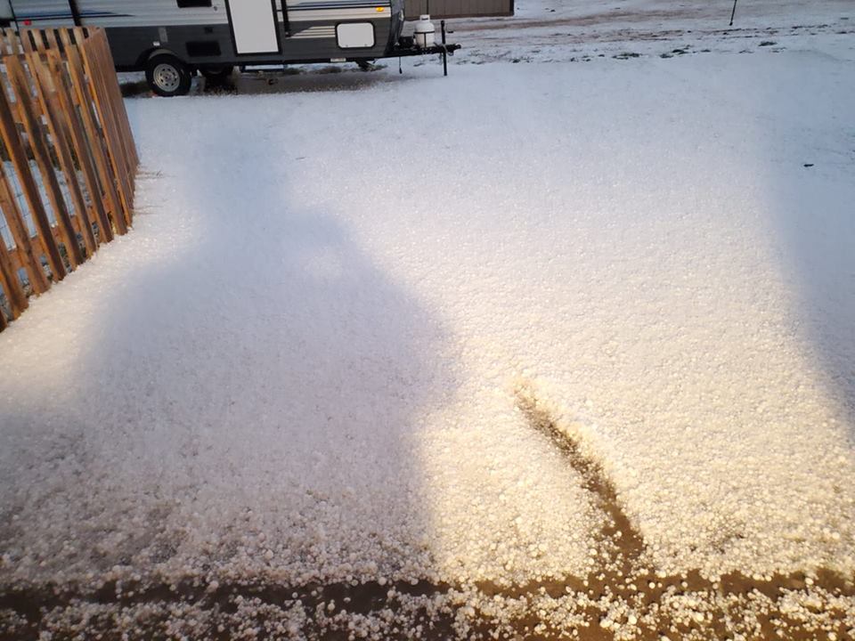
Hail Accumulation in Canyon (Lauri Meaker Minton) |
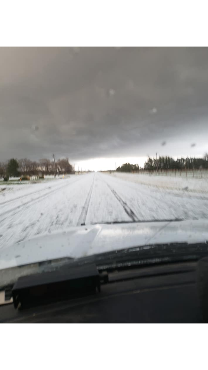
Various Hail Sizes Between I27 & Soncy (Lauri Meaker Minton) |
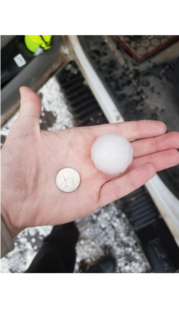
Golf Ball Size Hail in Deaf Smith County (Ben Elmore) |
Hail Accumulation on FM 1058 in Deaf Smith County (Ben Elmore) |
 |
 |
 |
 |
|
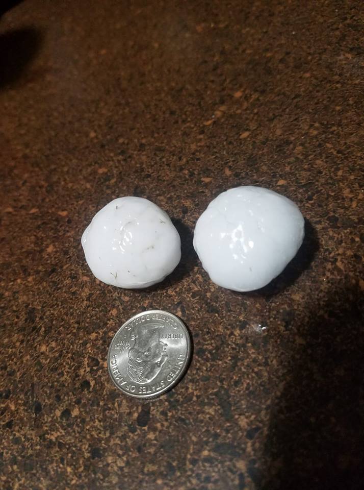
Quarter Size Hail in Lake Tanglewood (Sandee Taylor) |
Accumulated Hail Near Rockwell Rd Between Canyon and Amarillo (Ricky Martinez) |
Accumulated Hail Between Canyon and Amarillo (Ricky Martinez) |
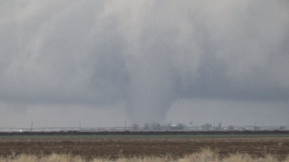
Tornado Near Cactus (Blaize Edwards) |
Radar
 |
 |
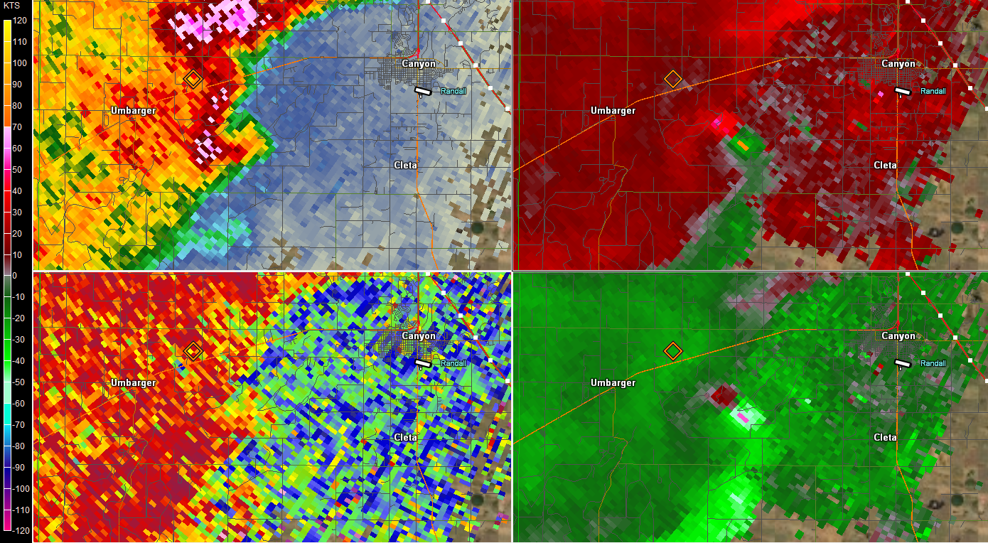 |
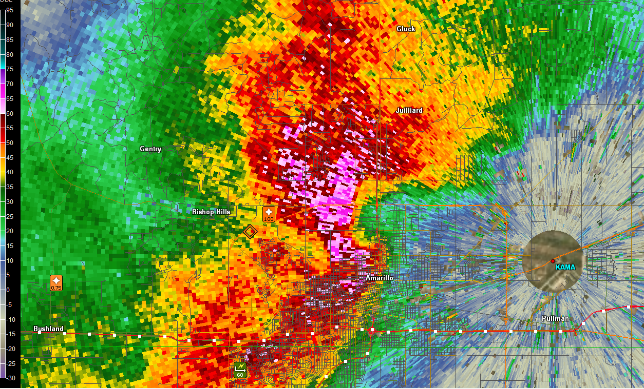
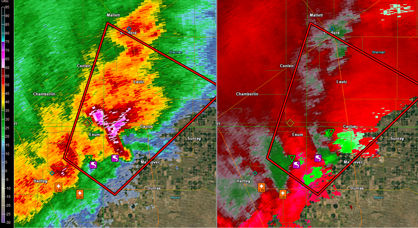
| Radar showing pronounced hook as storm with rotation approaches Amarillo, TX. | Tornadic storm southwest of Cactus, TX. | Strong rotation in storm near Canyon, TX. |
Storm Reports
PRELIMINARY LOCAL STORM REPORT...SUMMARY
NATIONAL WEATHER SERVICE AMARILLO TX
1204 AM CDT SAT MAR 23 2019
..TIME... ...EVENT... ...CITY LOCATION... ...LAT.LON...
..DATE... ....MAG.... ..COUNTY LOCATION..ST.. ...SOURCE....
..REMARKS..
0406 PM HAIL 15 NE ROMERO 35.88N 102.75W
03/22/2019 E1.00 INCH HARTLEY TX TRAINED SPOTTER
TRAINED SPOTTER REPORTED QUARTER SIZE HAIL WITH
THUNDERSTORM.
0423 PM TSTM WND DMG HOOKER 36.86N 101.21W
03/22/2019 TEXAS OK EMERGENCY MNGR
THUNDERSTORM WINDS CAUSED DAMAGE TO BRICK BUILDING.
0441 PM TSTM WND GST 11 WNW BOOTLEG 34.89N 102.99W
03/22/2019 M58 MPH DEAF SMITH TX MESONET
0451 PM HAIL 4 ESE HARTLEY 35.87N 102.33W
03/22/2019 M1.75 INCH HARTLEY TX TRAINED SPOTTER
GOLF BALL SIZE HAIL REPORTED BY TRAINED SPOTTER.
0502 PM HAIL 9 ESE HARTLEY 35.85N 102.25W
03/22/2019 E1.00 INCH HARTLEY TX TRAINED SPOTTER
STORM CHASER REPORTING QUARTER SIZE HAIL WITH
ACCUMULATION ON AREA ROADWAYS.
0508 PM TORNADO 8 SE WILCO 35.94N 102.20W
03/22/2019 HARTLEY TX STORM CHASER
BRIEF TORNADO TOUCHDOWN REPORTED BY 3 STORM CHASERS AND
1 STORM SPOTTER.
0520 PM TORNADO 9 SW CACTUS 35.96N 102.12W
03/22/2019 MOORE TX STORM CHASER
MULTIPLE STORM CHASERS REPORTED A TORNADO, POSSIBLY
RAIN WRAPPED, ON THE GROUND. PICTURE CONFIRMATION SENT.
0551 PM HAIL 10 S VEGA 35.10N 102.43W
03/22/2019 M1.75 INCH DEAF SMITH TX TRAINED SPOTTER
0607 PM TSTM WND GST 11 WNW BOOTLEG 34.89N 102.99W
03/22/2019 M59 MPH DEAF SMITH TX MESONET
0621 PM HAIL 4 SSE WILDORADO 35.17N 102.21W
03/22/2019 M1.00 INCH DEAF SMITH TX TRAINED SPOTTER
0622 PM HAIL 7 SSE WILDORADO 35.13N 102.20W
03/22/2019 M1.50 INCH DEAF SMITH TX TRAINED SPOTTER
0640 PM HAIL 4 WNW BUSHLAND 35.20N 102.13W
03/22/2019 M0.88 INCH POTTER TX STORM CHASER
0642 PM HAIL 2 N BUSHLAND 35.22N 102.06W
03/22/2019 M0.88 INCH POTTER TX PUBLIC
THIS HAIL IS ACCUMULATING ON THE GROUND.
0650 PM HAIL 5 SW HEREFORD 34.77N 102.46W
03/22/2019 M1.50 INCH DEAF SMITH TX FIRE DEPT/RESCUE
0700 PM TSTM WND GST 2 WNW HEREFORD 34.83N 102.43W
03/22/2019 M67 MPH DEAF SMITH TX MESONET
0702 PM TSTM WND GST 7 WSW AMARILLO 35.17N 101.93W
03/22/2019 M60 MPH RANDALL TX TRAINED SPOTTER
0703 PM HAIL 6 NW AMARILLO 35.26N 101.91W
03/22/2019 M1.00 INCH POTTER TX TRAINED SPOTTER
HAIL IS ACCUMULATING ON THE GROUND SEVERAL INCHES DEEP.
0707 PM HAIL HEREFORD 34.82N 102.40W
03/22/2019 M2.75 INCH DEAF SMITH TX FIRE DEPT/RESCUE
0717 PM HAIL 6 SW AMARILLO 35.15N 101.89W
03/22/2019 M0.75 INCH RANDALL TX NWS EMPLOYEE
ACCUMULATING HAIL REPORTED IN SOUTH AMARILLO.
0731 PM HAIL 7 NE AMARILLO 35.27N 101.73W
03/22/2019 M1.50 INCH POTTER TX BROADCAST MEDIA
0732 PM HAIL HEREFORD 34.82N 102.40W
03/22/2019 M1.50 INCH DEAF SMITH TX SOCIAL MEDIA
0745 PM FLOOD HEREFORD 34.82N 102.40W
03/22/2019 DEAF SMITH TX EMERGENCY MNGR
AREA ROADWAYS WERE FLOODING IN THE CITY OF HEREFORD.
0803 PM HAIL 4 NE UMBARGER 34.99N 102.06W
03/22/2019 M1.75 INCH RANDALL TX TRAINED SPOTTER
REPORT RECEIVED VIA SPOTTER NETWORK.
0805 PM HAIL 4 W CANYON 34.99N 102.00W
03/22/2019 M2.50 INCH RANDALL TX STORM CHASER
0807 PM HAIL 2 W CANYON 34.99N 101.95W
03/22/2019 E1.00 INCH RANDALL TX PUBLIC
MPING REPORT.
0808 PM HAIL 1 N CANYON 35.00N 101.92W
03/22/2019 M2.50 INCH RANDALL TX TRAINED SPOTTER
REPORT RECEIVED VIA SPOTTER NETWORK.
0813 PM HAIL 4 N CANYON 35.04N 101.92W
03/22/2019 M1.00 INCH RANDALL TX PUBLIC
0815 PM HAIL 2 E CANYON 34.98N 101.88W
03/22/2019 E1.00 INCH RANDALL TX TRAINED SPOTTER
HIGHWAY IS COVERED WITH HAIL UP TO THE SIZE OF
QUARTERS.
0822 PM HAIL 1 N LAKE TANGLEWOOD 35.08N 101.79W
03/22/2019 E1.00 INCH RANDALL TX PUBLIC
0824 PM HAIL 1 S LAKE TANGLEWOOD 35.04N 101.78W
03/22/2019 E0.75 INCH RANDALL TX PUBLIC
0829 PM HAIL LAKE TANGLEWOOD 35.06N 101.78W
03/22/2019 E1.25 INCH RANDALL TX PUBLIC
0945 PM HAIL 3 E GOODNIGHT 35.03N 101.13W
03/22/2019 E2.50 INCH ARMSTRONG TX BROADCAST MEDIA
GOLFBALL UP TO TENNIS BALL SIZE HAIL ON HIGHWAY 287
EAST OF GOODNIGHT RESULTED IN A CRACKED WINDSHIELD.
1002 PM HAIL HOWARDWICK 35.04N 100.91W
03/22/2019 E1.00 INCH DONLEY TX TRAINED SPOTTER
 |
Media use of NWS Web News Stories is encouraged! Please acknowledge the NWS as the source of any news information accessed from this site. |
|

