Hazardous heat will continue across the Southern Plains, Gulf Coast and Desert Southwest through the weekend. Additional heat will build into the Great Basin and Northern Plains this weekend. A stalled front is expected to bring periods of heavy to excessive rainfall and flooding from the Tennessee Valley to the Southeast U.S on Friday. Read More >
Overview
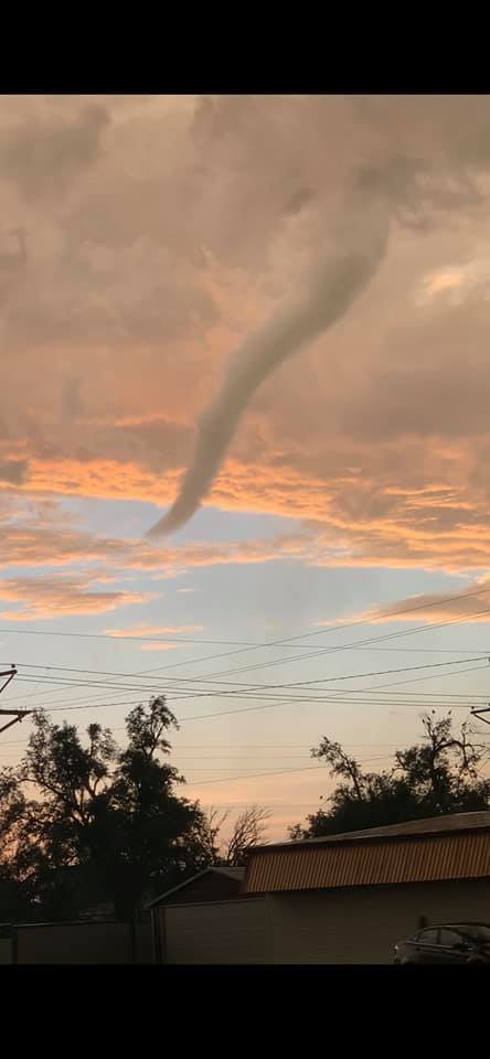
The period of May 23rd through May 30th brought a highly active weather pattern to the Texas and Oklahoma Panhandles, with most days featuring either severe thunderstorms or the plausible threat of the development of severe thunderstorms. A Watch was issued on 7 of these 8 days; 5 days with a Severe Thunderstorm Watch and 2 with a Tornado Watch. Either large hail, damaging winds, wind damage, or tornadoes were reported on 5 of these 8 days. Two of these days, May 26th and May 30th, featured multiple tornadoes, with May 29th featuring a notable supercell in Cimarron County.
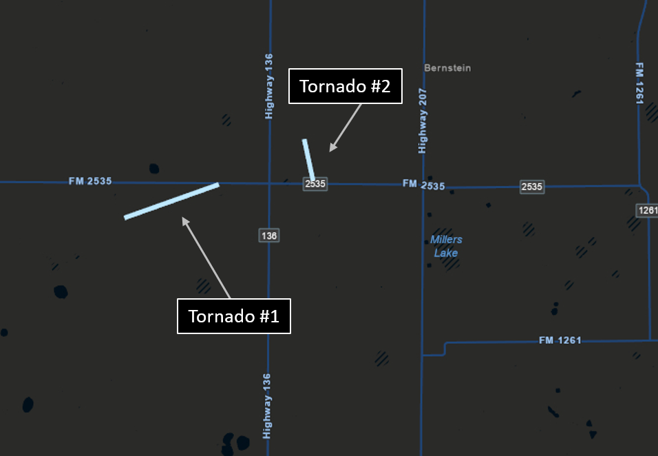
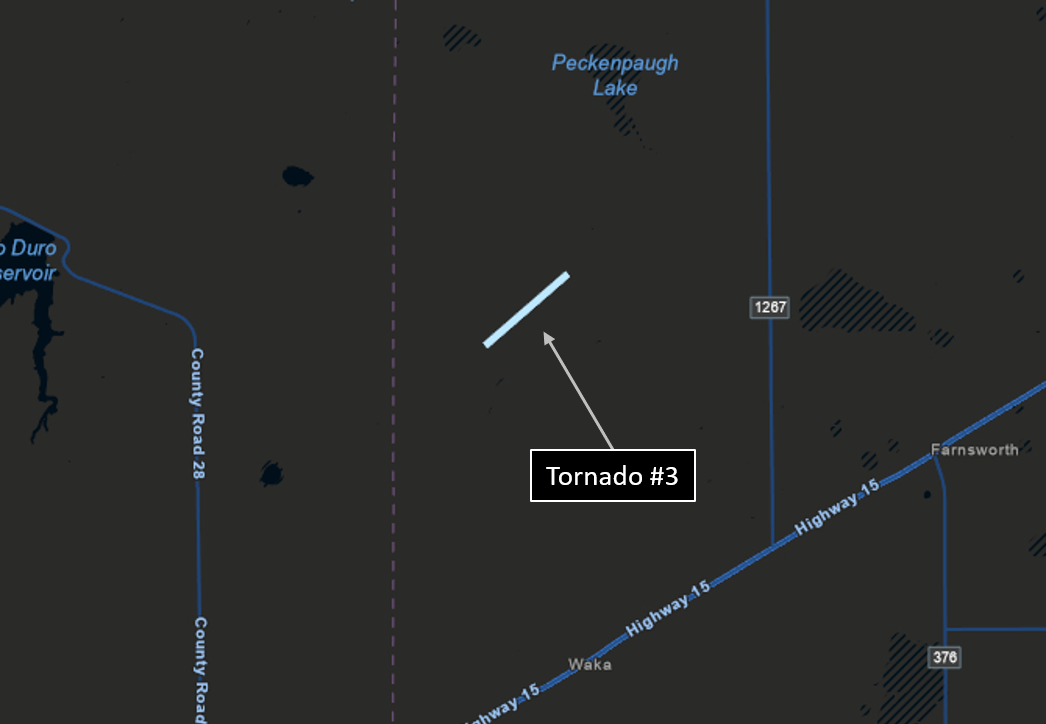
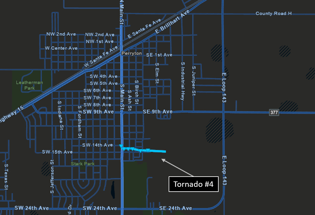
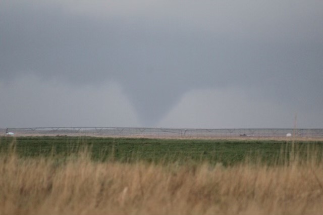
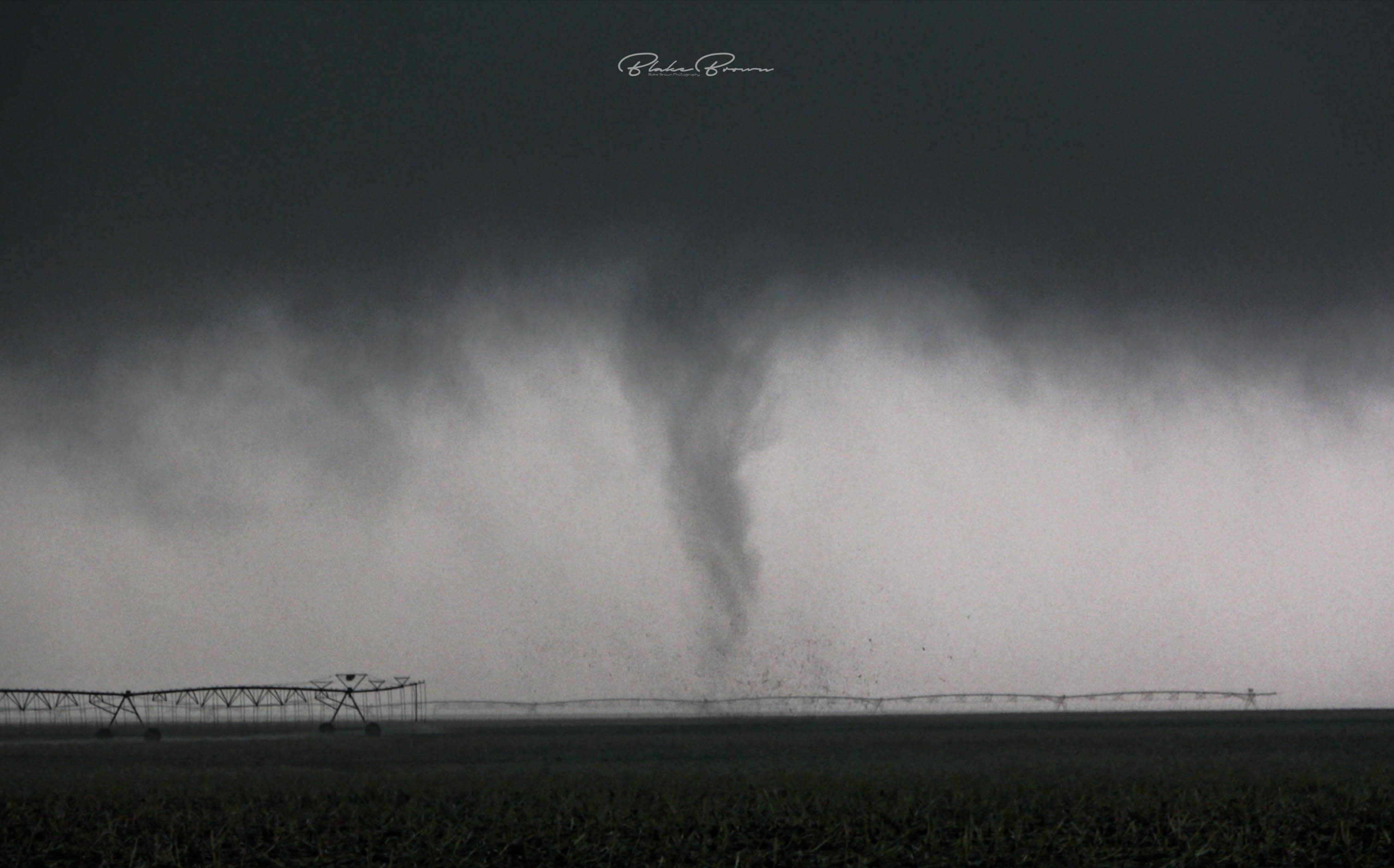
May 26th, an upper level storm system, initially over the southwestern United States, approached the area and sent various disturbances across the region. With ample moisture, instability, and increased wind shear, thunderstorms initiated along a dryline and progressed towards the northeast and east. A couple of the storms became supercells, which were the cause of the 4 reported tornadoes on this date. The only tornado that affected damage indicators occurred in the Perryton area, which received a rating of EF-0 with estimated wind speeds up to 75 mph. The longest tracked tornado, which occurred north of Gruver, was caught on video by multiple storm chasers with a path length approaching 1.9 miles.
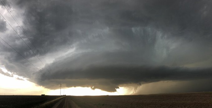
May 29th, storms developed on the higher terrain to our west and threatened the western Panhandles. During the evening hours, a supercell thunderstorm tracked into the western Oklahoma Panhandle from southeastern Colorado. Despite contemporaneous reports from multiple chasers that a large tornado was in progress, following the viewing of later video and picture evidence, the collection of testimony from other chasers in the area, and the completion of a damage survey that found no damage, it was concluded that no tornado occurred with this supercell. While no tornado occurred, this supercell was a prolific hail producer, with multiple reports of baseball size hail. Given the sparse road network, it is possible that the largest hailstones generated by this storm were not located by storm spotters. Later that night, a robust line of storms entered the western Texas Panhandle from New Mexico, with an 86 mph wind gust recorded by the West Texas Mesonet site southwest of Romero.
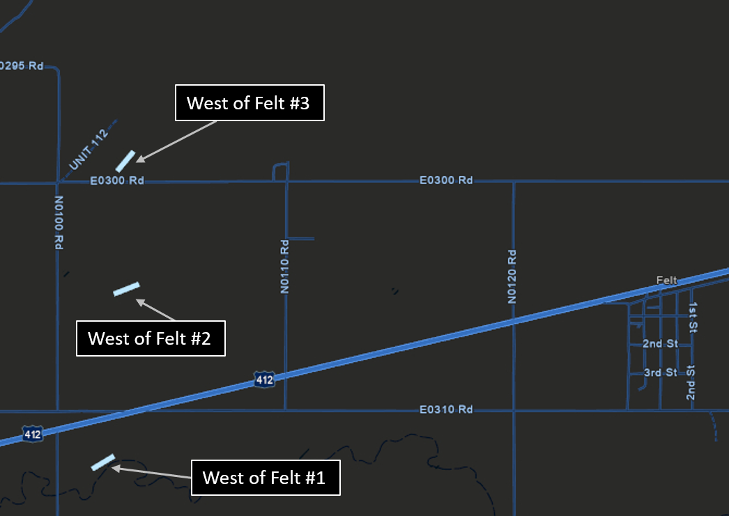
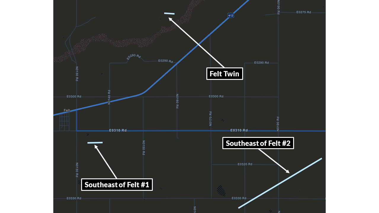
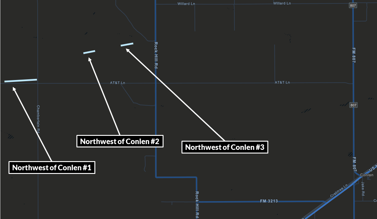
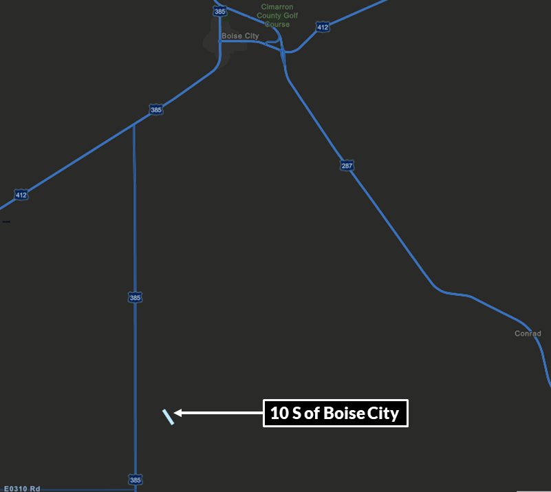
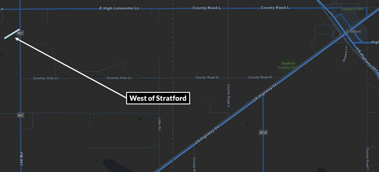
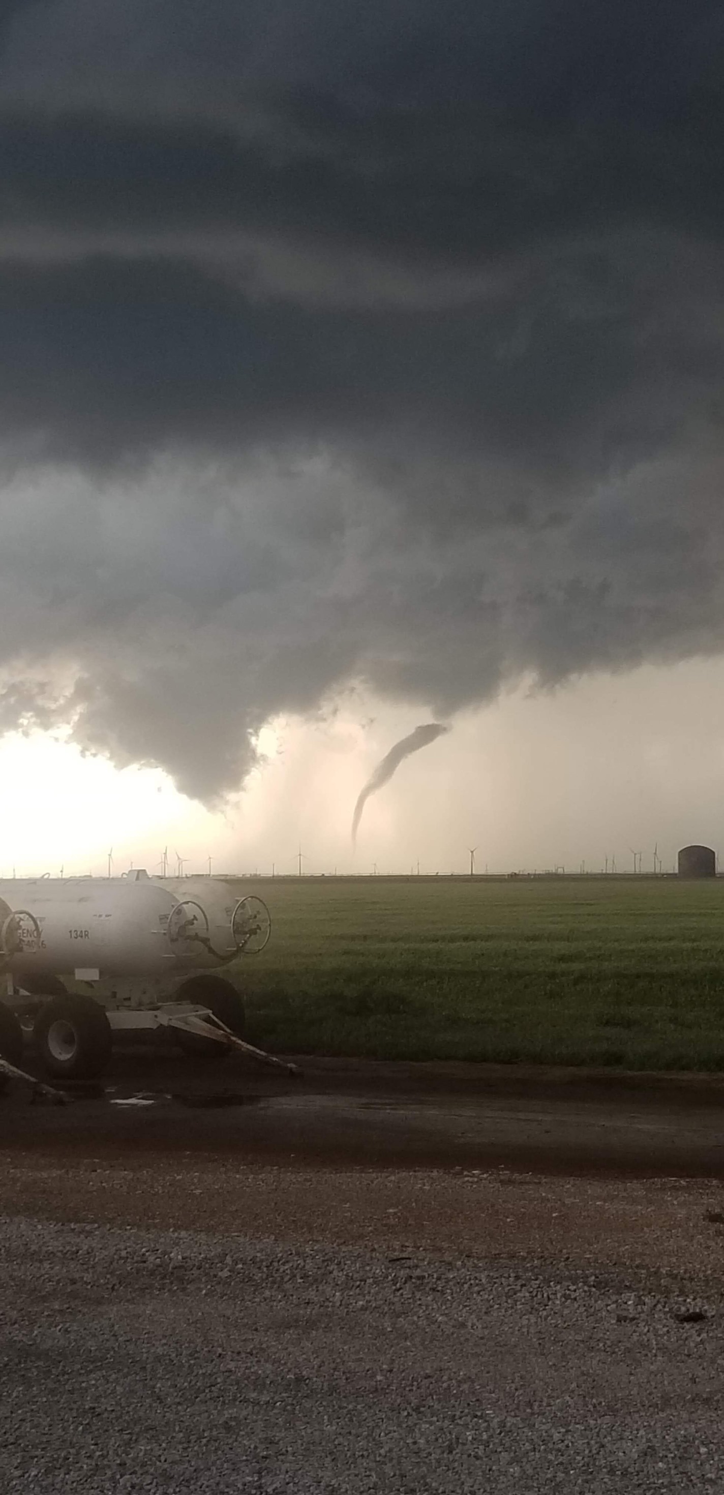
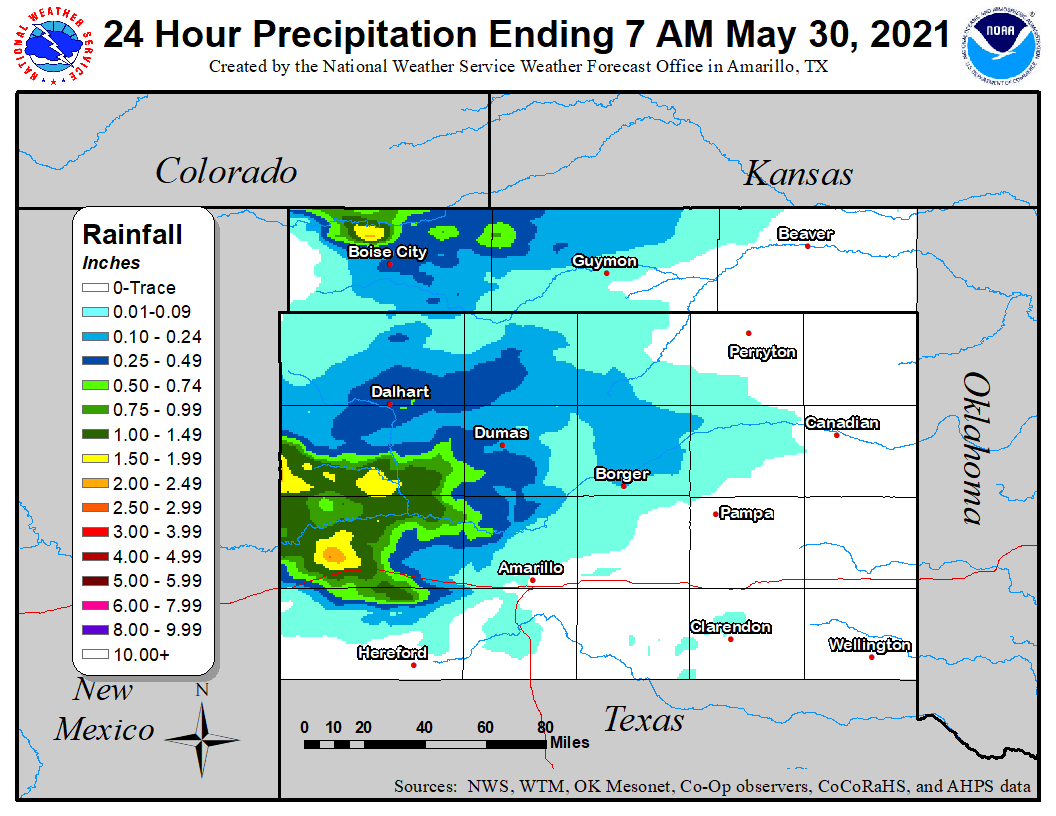
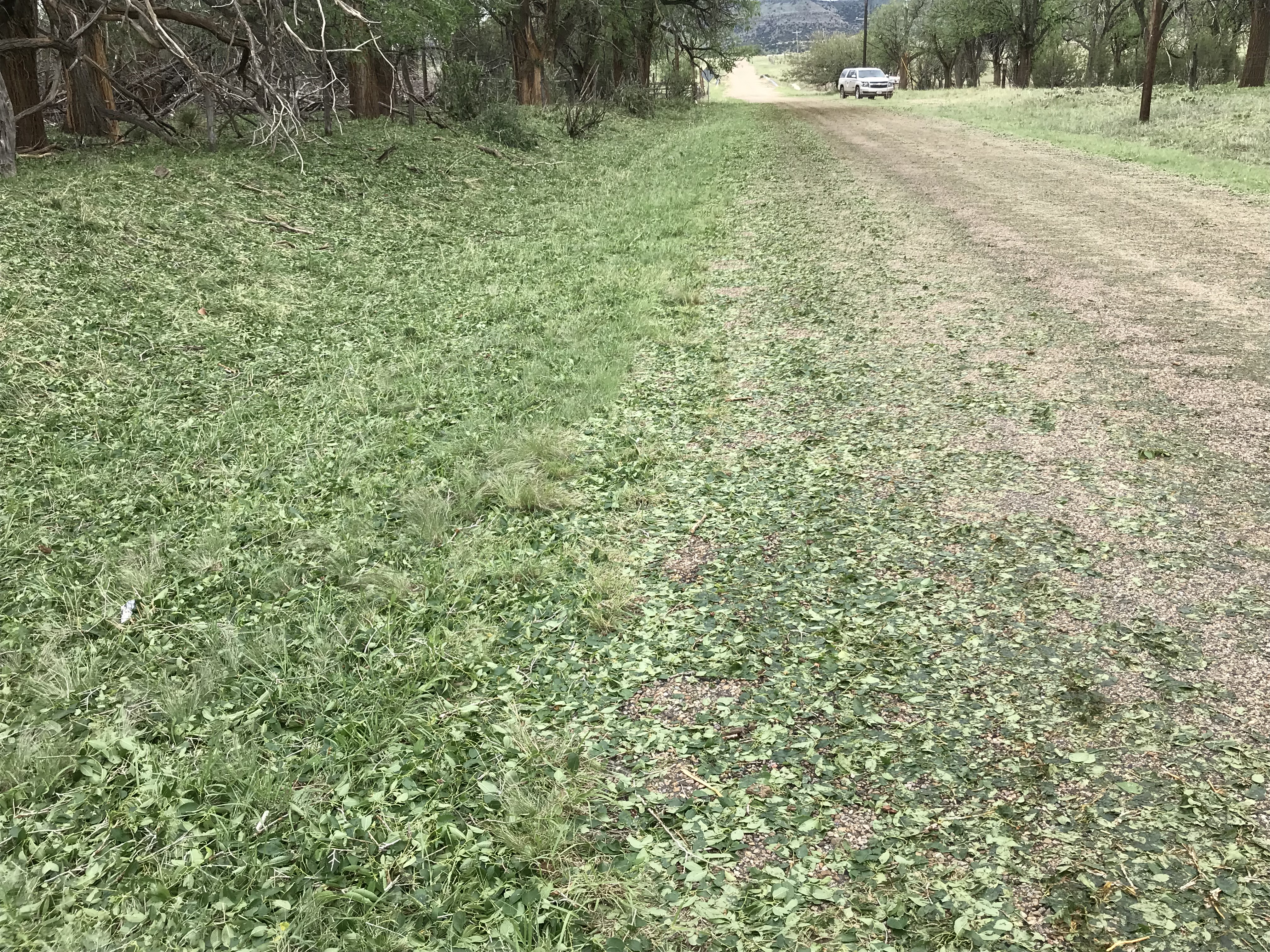
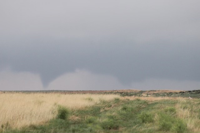
May 30th, persistent low level winds out of the east brought substantial moisture to the region, allowing thunderstorms to break out as an upper level disturbance approached from the southwest. With surface winds out of the east in place underneath winds aloft out of the southwest, low level wind shear was sufficient for multiple tornadoes to develop with some of these thunderstorms. A total of 13 tornadoes were confirmed. Seven tornadoes occurred in Cimarron County, mainly in the vicinity of Felt, all of which occurred over open land, resulting in no EF rating being assigned to any of these tornadoes. Six tornadoes occurred in Dallam and Sherman Counties, all of which were rated EF-0 or were unable to be rated due to a lack of damage indicators. Additionally, heavy rainfall occurred in many locations given the large amount of moisture in place, with flash flooding occurring in Amarillo, Canyon, and Wellington. Some locations received more than 4 inches of rainfall.
Tornadoes:
|
Tornado - North of Gruver #1
|
||||||||||||||||
|
Tornado - North of Gruver #2
|
||||||||||||||||
|
Tornado - North of Waka
|
||||||||||||||||
|
Tornado - Perryton
|
||||||||||||||||
The Enhanced Fujita (EF) Scale classifies tornadoes into the following categories:
| EF0 Weak 65-85 mph |
EF1 Moderate 86-110 mph |
EF2 Significant 111-135 mph |
EF3 Severe 136-165 mph |
EF4 Extreme 166-200 mph |
EF5 Catastrophic 200+ mph |
 |
|||||
Photos & Video
 |
 |
| Tornado near Waka (Jeff Staton) |
Supercell thunderstorm near Perryton (Matt Woods) |
 |
 |
| Tornado near Waka (Thomas Beal) |
Funnel cloud over Pampa; this did not touch down (Armando Garcia III) |
Radar
| Radar loop with warnings from the May 26th, 2021 severe weather event. Radar, warnings from NWS; animation from Iowa Environmental Mesonet |
Storm Reports
 |
| Map of non-tornado storm reports from May 26th, 2021. Reports from NWS; map courtesy Iowa Environmental Mesonet. |
This table contains all non-tornado reports received on May 26th, 2021. For information on the tornadoes, see the tornado section at the top of this tab.
| Report Time (CDT) | County | Location | State | Event Type | Magnitude | Source | Lat | Lon | Remark |
| 2021/05/26 17:16 | POTTER | 4 NW WASHBURN | TX | HAIL | 1.25 | STORM CHASER | 35.21 | -101.63 | MOSTLY HALF INCH TO QUARTER, A FEW HALF DOLLAR SIZE HAIL. |
| 2021/05/26 18:14 | CARSON | 3 WSW PANHANDLE | TX | HAIL | 1 | STORM CHASER | 35.32 | -101.43 | |
| 2021/05/26 18:28 | HANSFORD | 7 NNE GRUVER | TX | HAIL | 3 | STORM CHASER | 36.34 | -101.35 | LATE REPORT OF 3 INCH HAIL RECEIVED WITH PICTURE. |
| 2021/05/26 18:29 | CARSON | PANHANDLE | TX | HAIL | 1.5 | TRAINED SPOTTER | 35.34 | -101.39 | |
| 2021/05/26 18:33 | HANSFORD | 8 NNE GRUVER | TX | HAIL | 2 | STORM CHASER | 36.36 | -101.36 | REPORT RECEIVED VIA SPOTTER NETWORK. |
| 2021/05/26 18:38 | HANSFORD | 8 NNE GRUVER | TX | HAIL | 2.75 | STORM CHASER | 36.36 | -101.35 | LATE STORM CHASER REPORT OF BASEBALL SIZE HAIL. |
| 2021/05/26 18:40 | CARSON | 1 N PANHANDLE | TX | HAIL | 2 | PUBLIC | 35.36 | -101.38 | TWITTER REPORT WITH PICTURE OF MEASURED 2 INCH HAIL. |
| 2021/05/26 18:42 | BEAVER | BRYANS CORNER | OK | HAIL | 0.88 | EMERGENCY MNGR | 36.62 | -100.82 | ACCUMULATING HAIL OCCURRING. |
| 2021/05/26 18:49 | CARSON | 4 SW PANHANDLE | TX | HAIL | 2.5 | PUBLIC | 35.31 | -101.43 | PICTURE RECEIVED VIA TWITTER. |
| 2021/05/26 18:53 | CARSON | PANHANDLE | TX | HAIL | 2.5 | PUBLIC | 35.35 | -101.38 | PICTURE RECEIVED VIA TWITTER. |
| 2021/05/26 18:56 | POTTER | 7 E AMARILLO | TX | TSTM WND GST | 60 | ASOS | 35.22 | -101.71 | RICK HUSBAND INTL AIRPORT ASOS MEASURED 60 MPH WIND GUST. |
| 2021/05/26 19:05 | HANSFORD | 9 NW WAKA | TX | TSTM WND GST | 77 | MESONET | 36.36 | -101.18 | PALO DURO RESERVOIR 1 NW. |
| 2021/05/26 19:14 | BEAVER | 3 N ELMWOOD | OK | HAIL | 1.25 | EMERGENCY MNGR | 36.66 | -100.52 | |
| 2021/05/26 19:39 | CARSON | 5 N PANHANDLE | TX | HAIL | 2.5 | TRAINED SPOTTER | 35.42 | -101.38 | |
| 2021/05/26 19:45 | OCHILTREE | 8 N FARNSWORTH | TX | HAIL | 0.75 | PUBLIC | 36.43 | -100.94 | REPORT FROM MPING: DIME (0.75 IN.). |
| 2021/05/26 20:11 | CARSON | 4 NE WHITE DEER | TX | HAIL | 1 | TRAINED SPOTTER | 35.46 | -101.12 | |
| 2021/05/26 20:11 | BEAVER | 7 E ELMWOOD | OK | TSTM WND GST | 62 | MESONET | 36.62 | -100.39 | |
| 2021/05/26 20:14 | CARSON | 1 S SKELLYTOWN | TX | HAIL | 1 | TRAINED SPOTTER | 35.55 | -101.17 | |
| 2021/05/26 20:20 | OCHILTREE | 2 N PERRYTON | TX | HAIL | 2.5 | TRAINED SPOTTER | 36.43 | -100.8 | GOLF BALL TO TENNIS BALL SIZE HAIL REPORTED. |
| 2021/05/26 20:23 | OCHILTREE | 8 E PERRYTON | TX | HAIL | 2.5 | STORM CHASER | 36.39 | -100.67 | |
| 2021/05/26 20:47 | OCHILTREE | PERRYTON | TX | FLOOD | TRAINED SPOTTER | 36.39 | -100.8 | TRAINED SPOTTER REPORTS WATER OVER ROADWAY ON 9TH AND MAIN AS WELL AS 15TH AND MAIN. | |
| 2021/05/26 20:47 | GRAY | 2 N PAMPA | TX | HAIL | 1 | TRAINED SPOTTER | 35.57 | -100.97 |
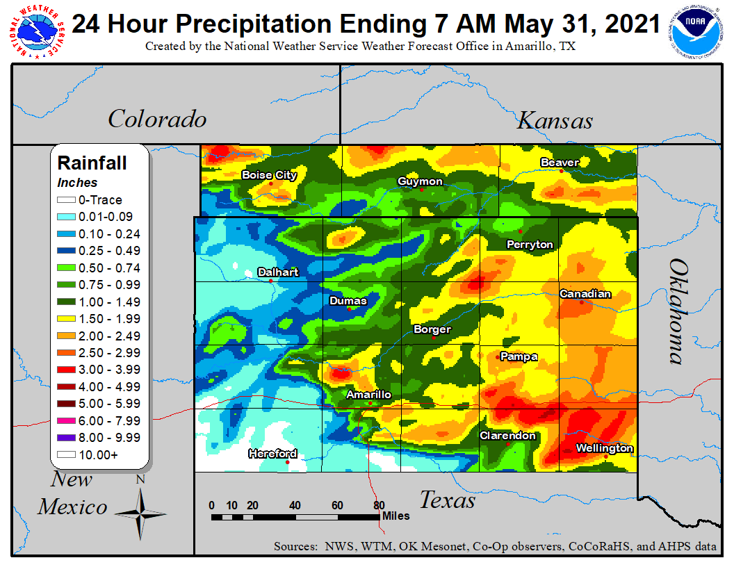
Rain Reports
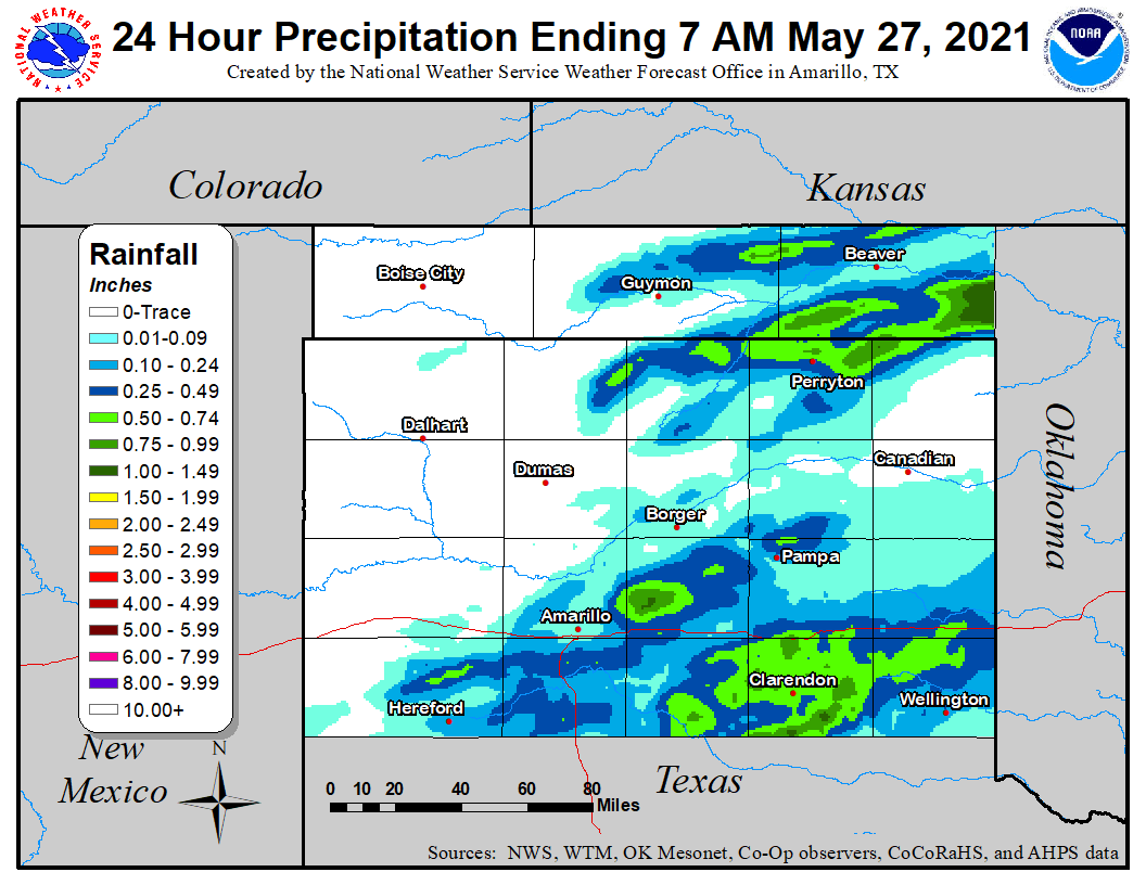 |
| Rainfall estimate map created using a combination of radar (AHPS) data and ASOS, AWOS, West Texas Mesonet, Oklahoma Mesonet, CoCoRaHS, and COOP rain gauge data. |
Zero Confirmed Tornadoes:
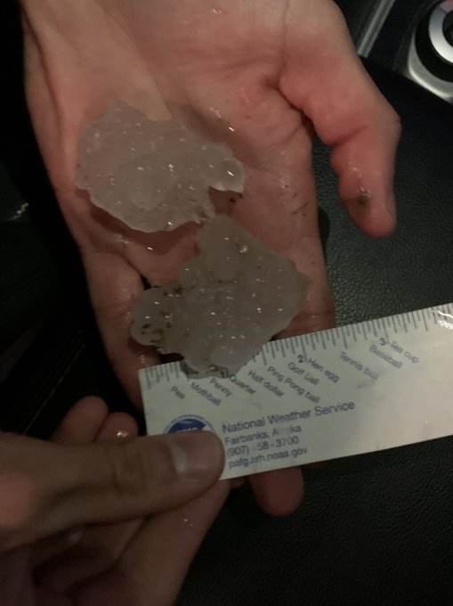
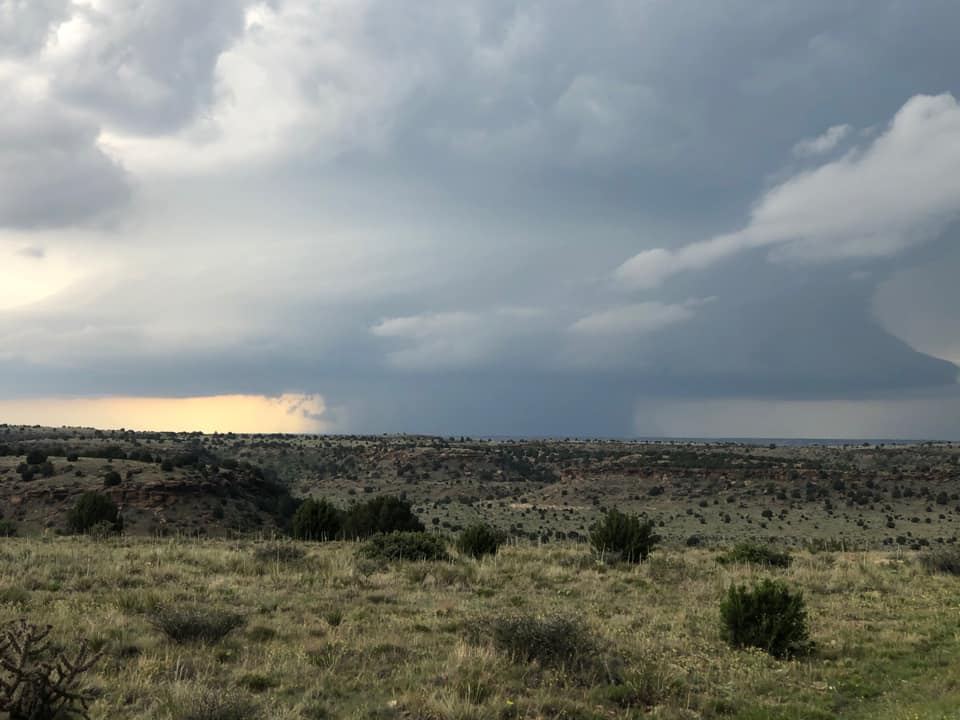
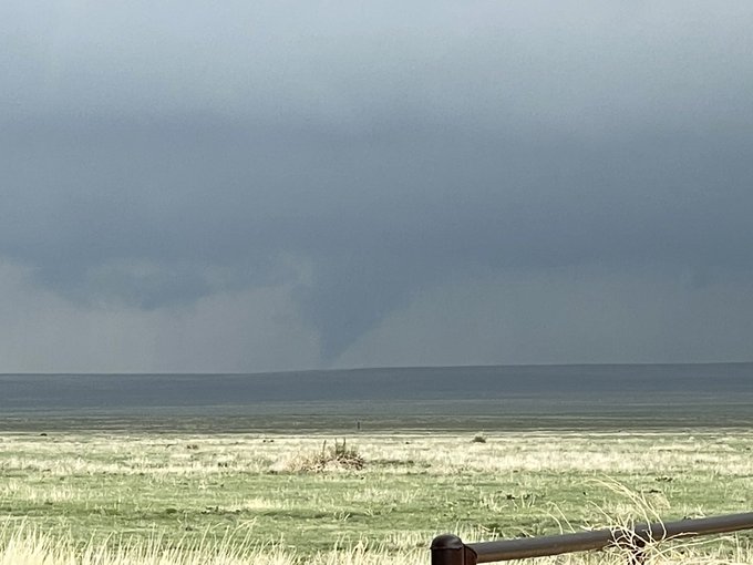
On Saturday May 29th, 2021, several nighttime pictures and videos were taken by spotters and storm chasers of an ominous large cloud lowering in northwestern Cimarron County. This cloud lowering was near the ground within the updraft of a supercell tracking southeast out of Colorado. However, no damage was found to support that a large tornado occurred. Since then, other images and video from different vantage points, along with testimony from other storm chasers in the area, suggest this may have been a very large scud cloud aided by cool southeast upslope flow.
Photos & Video
 |
 |
| 2.25" diameter hailstones found 6 miles north of Kenton (Joe Moore) |
Supercell near Black Mesa Park (Ryan Nostrud) |
Radar
| Radar loop with warnings from the May 29th, 2021 severe weather event. Radar, warnings from NWS; animation from Iowa Environmental Mesonet |
Storm Reports
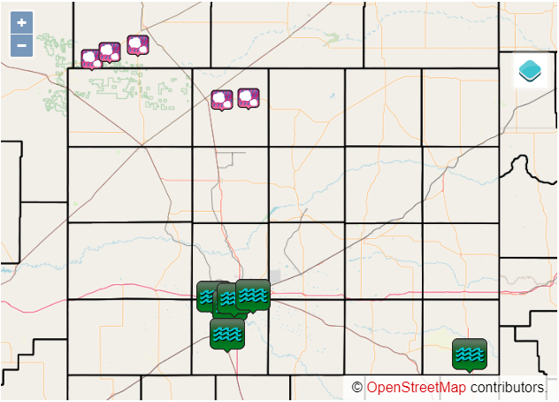
 |
| Map of non-tornado storm reports from May 29th, 2021. Reports from NWS; map courtesy Iowa Environmental Mesonet. |
This table contains all non-tornado reports received on May 29th, 2021. For information on the tornadoes, see the tornado section at the top of this tab.
| Report Time (CDT) | County | Location | State | Event Type | Magnitude | Source | Lat | Lon | Remark |
| 2021/05/29 20:25 | CIMARRON | 4 N KENTON | OK | HAIL | 2 | STORM CHASER | 36.96 | -102.97 | REPORT RECEIVED VIA SOCIAL MEDIA. |
| 2021/05/29 20:40 | CIMARRON | 4 E KENTON | OK | HAIL | 2.5 | TRAINED SPOTTER | 36.91 | -102.9 | |
| 2021/05/29 20:45 | CIMARRON | BLACK MESA PARK | OK | HAIL | 2 | STORM CHASER | 36.85 | -102.88 | LARGEST HAIL STONES FOUND WERE 2 INCHES WITH ACCUMULATING HAIL. REPORT RECEIVED VIA SOCIAL MEDIA. |
| 2021/05/29 20:47 | CIMARRON | 4 NNE KENTON | OK | HAIL | 1.75 | EMERGENCY MNGR | 36.96 | -102.95 | |
| 2021/05/29 21:05 | CIMARRON | 4 N BLACK MESA PARK | OK | HAIL | 2.75 | TRAINED SPOTTER | 36.9 | -102.88 | |
| 2021/05/29 21:26 | CIMARRON | 5 NE BLACK MESA PARK | OK | HAIL | 2.5 | TRAINED SPOTTER | 36.9 | -102.82 | REPORT RECEIVED AT 9:40 PM. TIME ESTIMATED BASED ON RADAR. |
| 2021/05/29 21:42 | CIMARRON | 6 N KENTON | OK | HAIL | 2.5 | PUBLIC | 36.99 | -102.97 | LATE REPORT RECEIVED VIA SOCIAL MEDIA WITH PICTURE AT 9:25 PM. |
| 2021/05/29 22:47 | CIMARRON | 7 N FELT | OK | HAIL | 2.75 | TRAINED SPOTTER | 36.67 | -102.79 | LATE REPORT OF BASEBALL SIZE HAIL, WITH TIME ESTIMATED FROM RADAR. |
| 2021/05/29 22:47 | CIMARRON | 8 NW BOISE CITY | OK | HAIL | 2.75 | TRAINED SPOTTER | 36.81 | -102.61 | CORRECTS PREVIOUS REPORT 7 N OF FELT TO BE 8 NW OF BOISE CITY. LATE REPORT OF BASEBALL SIZE HAIL, WITH TIME ESTIMATED FROM RADAR. |
| 2021/05/29 22:51 | CIMARRON | 11 N BOISE CITY | OK | HAIL | 0.75 | STORM CHASER | 36.88 | -102.52 | |
| 2021/05/30 01:22 | OLDHAM | 11 SSW ROMERO | TX | TSTM WND GST | 86 | MESONET | 35.58 | -103.01 | WEST TEXAS MESONET RECORDED 86 MPH WIND GUST. |
Rain Reports
 |
| Rainfall estimate map created using a combination of radar (AHPS) data and ASOS, AWOS, West Texas Mesonet, Oklahoma Mesonet, CoCoRaHS, and COOP rain gauge data. |
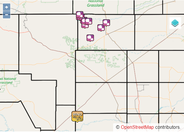
Tornadoes:
|
Tornado - West of Felt #1
|
||||||||||||||||
|
Tornado - West of Felt #2
|
||||||||||||||||
|
Tornado - West of Felt #3
|
||||||||||||||||
|
Tornado - Southeast of Felt #1
|
||||||||||||||||
|
Tornado - Southeast of Felt #2
|
||||||||||||||||
|
Tornado - Felt Twin
|
||||||||||||||||
|
Tornado - Northwest of Conlen #1
|
||||||||||||||||
|
Tornado - Northwest of Conlen #2
|
||||||||||||||||
|
Tornado - Northwest of Conlen #3
|
||||||||||||||||
|
Tornado - 10 Miles South of Boise City
|
||||||||||||||||
|
Tornado - West of Stratford
|
||||||||||||||||
|
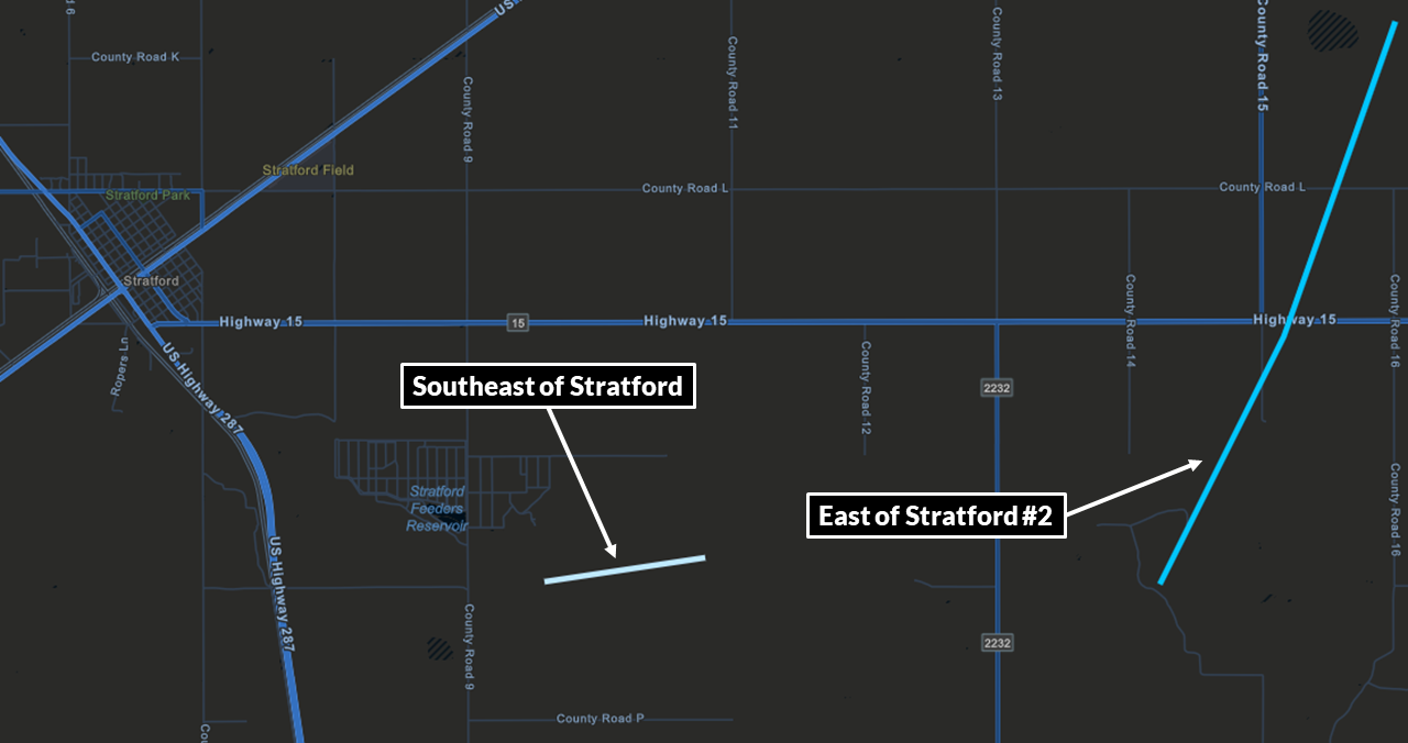
Tornado - Southeast of Stratford
|
||||||||||||||||
|
Tornado - East of Stratford #2
|
||||||||||||||||
The Enhanced Fujita (EF) Scale classifies tornadoes into the following categories:
| EF0 Weak 65-85 mph |
EF1 Moderate 86-110 mph |
EF2 Significant 111-135 mph |
EF3 Severe 136-165 mph |
EF4 Extreme 166-200 mph |
EF5 Catastrophic 200+ mph |
|
|||||
Photos & Video
 |
 |
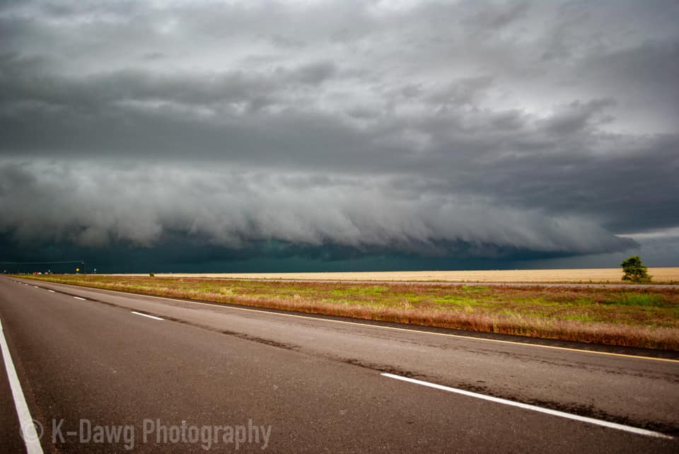
| Shelf cloud 6 miles south of Stratford (Greg AK) |
Tornado southeast of Felt (Matt Phelps) |
 |
 |
| Cone tornado southwest of Boise City (806 Storm Chasers) |
Tornado near Felt (Blake Brown) |
 |
 |
| Trees shredded due to hail near Black Mesa Park (Mike Gittinger) |
Two tornadoes simultaneously in progress southwest of Boise City (806 Storm Chasers) |
 |
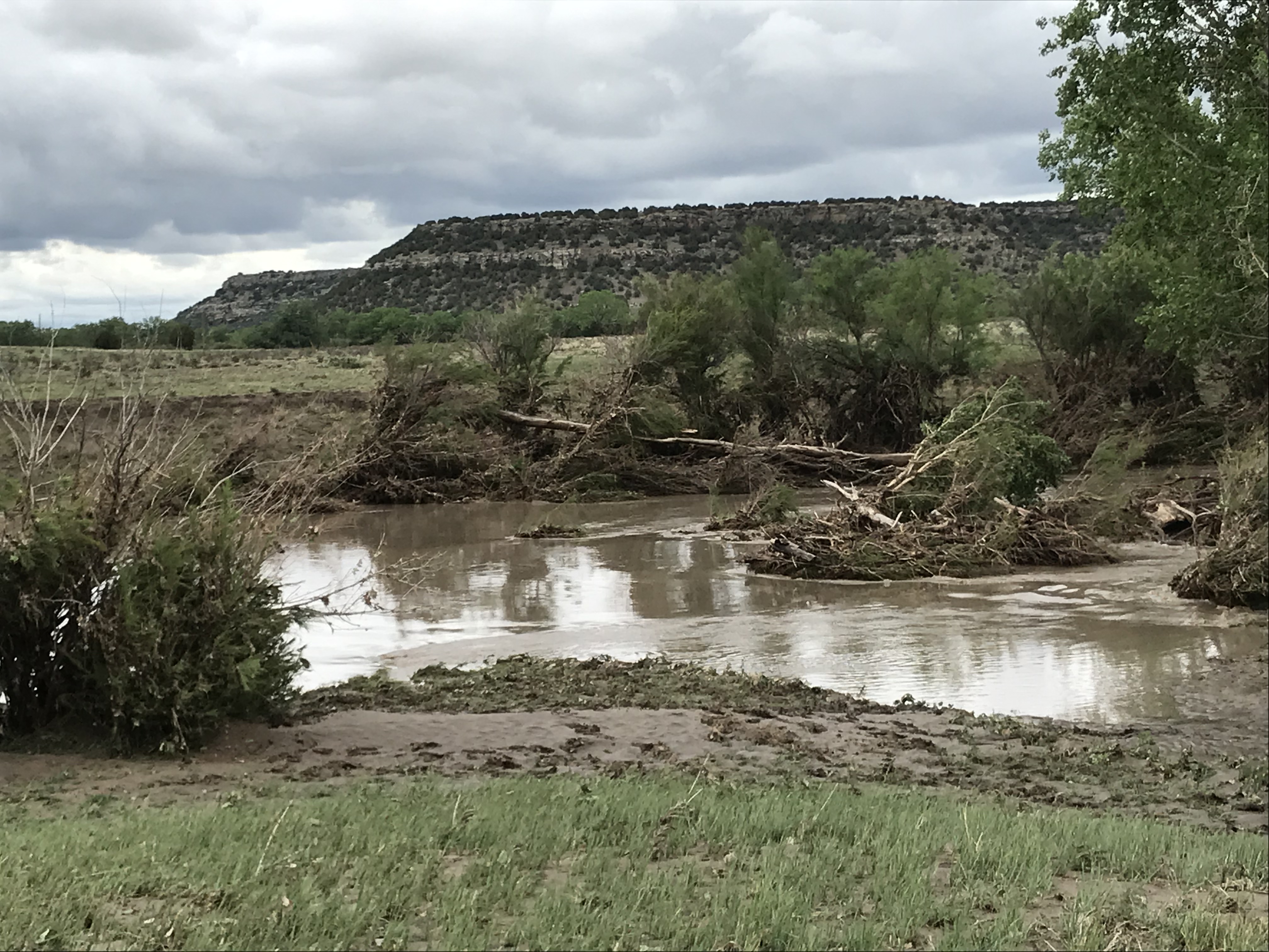 |
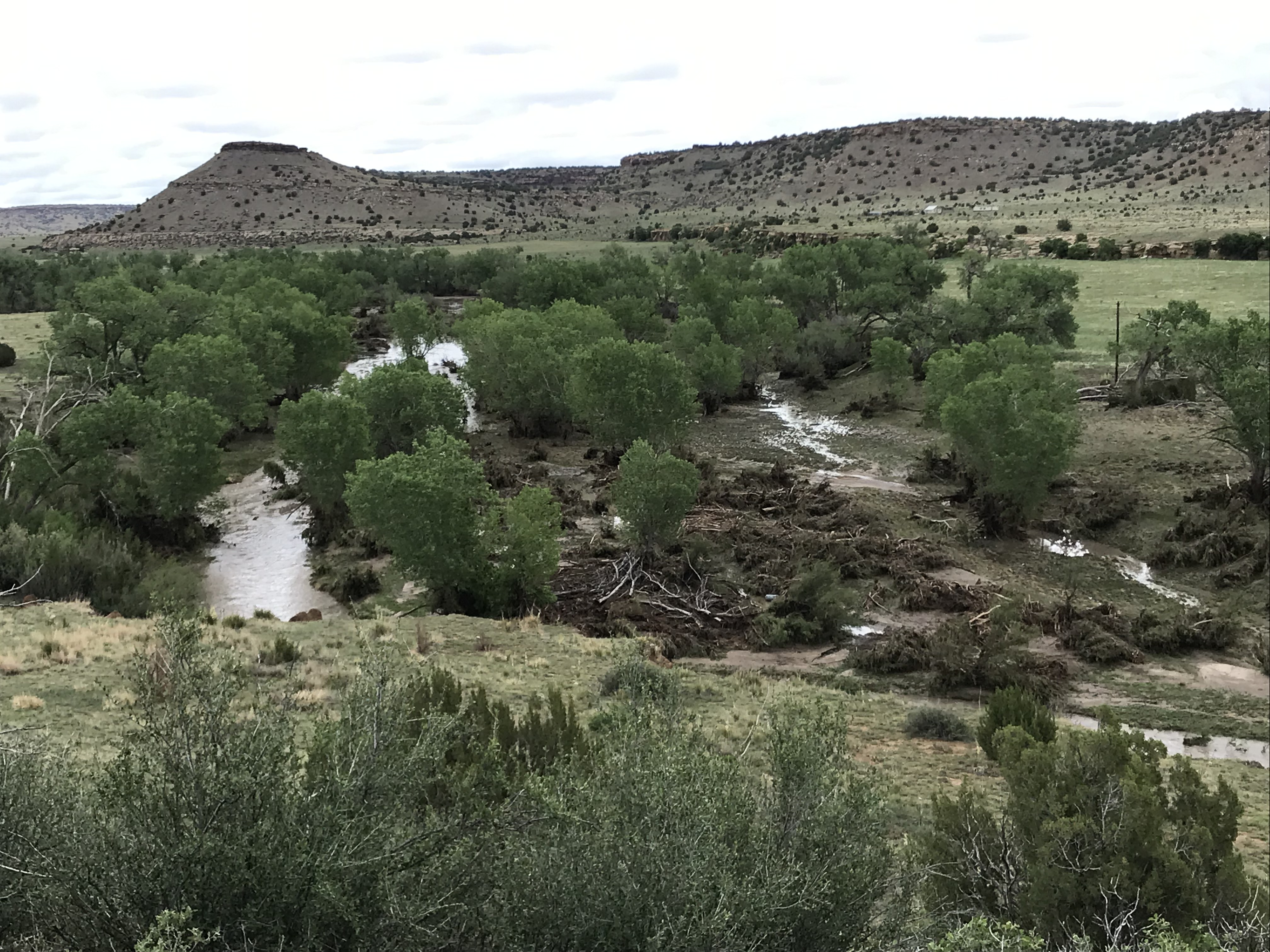
| Post-flooding debris on North Carrizo Creek (Mike Gittinger) |
Post-flooding debris on North Carrizo Creek (Mike Gittinger) |
Radar
| Radar loop with warnings from the May 30th, 2021 severe weather and flooding event. Radar, warnings from NWS; animation from Iowa Environmental Mesonet |
Storm Reports
 |
| Map of non-tornado storm reports from May 30th, 2021. Reports from NWS; map courtesy Iowa Environmental Mesonet. |
This table contains all non-tornado reports received on May 30th, 2021. For information on the tornadoes, see the tornado section at the top of this tab.
| Report Time (CDT) | County | Location | State | Event Type | Magnitude | Source | Lat | Lon | Remark |
| 2021/05/30 17:41 | CIMARRON | 5 WSW FELT | OK | HAIL | 1.75 | STORM CHASER | 36.55 | -102.87 | STORM CHASER REPORTS GOLF BALL SIZE HAIL. |
| 2021/05/30 18:00 | CIMARRON | 2 NE FELT | OK | HAIL | 1.25 | STORM CHASER | 36.59 | -102.75 | |
| 2021/05/30 18:27 | CIMARRON | 7 SSW BOISE CITY | OK | HAIL | 1.25 | STORM CHASER | 36.63 | -102.55 | |
| 2021/05/30 19:41 | SHERMAN | 6 ESE STRATFORD | TX | HAIL | 1.75 | STORM CHASER | 36.32 | -101.96 | |
| 2021/05/30 20:13 | SHERMAN | 11 SSE TEXHOMA | TX | HAIL | 1 | STORM CHASER | 36.33 | -101.77 | |
| 2021/05/30 23:48 | RANDALL | 7 WSW AMARILLO | TX | HAIL | 0.75 | PUBLIC | 35.16 | -101.93 | |
| 2021/05/30 23:53 | POTTER | 3 E BUSHLAND | TX | FLASH FLOOD | PUBLIC | 35.19 | -102.01 | ARNOT ROAD HAS RAPIDLY FLOWING WATER OVER ROADWAY, BECOMING IMPASSABLE. I-40 UNDERPASS ALSO STARTING TO FLOOD. | |
| 2021/05/30 23:54 | RANDALL | 6 SW AMARILLO | TX | FLASH FLOOD | PUBLIC | 35.14 | -101.9 | STREET FLOODING REPORTED ON SOUTH COULTER NEAR HOLLYWOOD ROAD CONSTRUCTION ZONES. | |
| 2021/05/31 00:13 | RANDALL | 3 SW AMARILLO | TX | FLASH FLOOD | PUBLIC | 35.18 | -101.87 | REPORT OF RAPIDLY FLOWING WATER ON GEORGIA STREET SOUTH OF 34TH AVE WHICH IS ABOVE CURBSIDE. | |
| 2021/05/31 00:33 | POTTER | 4 E AMARILLO | TX | FLASH FLOOD | STORM CHASER | 35.2 | -101.74 | STORM CHASER LIVE VIDEO SHOWING FLOWING WATER ON THE I-40 WEST FRONTAGE ROAD WEST OF LOOP 335. | |
| 2021/05/31 01:24 | RANDALL | CANYON | TX | FLASH FLOOD | PUBLIC | 34.98 | -101.92 | URBANIZED FLOODING WAS REPORTED IN CANYON AREA WITH HEAVY RAIN CONTINUING AT TIME OF REPORT. | |
| 2021/05/31 02:52 | COLLINGSWORTH | WELLINGTON | TX | FLASH FLOOD | LAW ENFORCEMENT | 34.86 | -100.21 | NUMEROUS ROADWAYS IN WELLINGTON FLOODED WITH SOME ROADS IMPASSABLE DUE TO FAST FLOWING WATER. |
Rain Reports
 |
| Rainfall estimate map created using a combination of radar (AHPS) data and ASOS, AWOS, West Texas Mesonet, Oklahoma Mesonet, CoCoRaHS, and COOP rain gauge data. |
 |
Media use of NWS Web News Stories is encouraged! Please acknowledge the NWS as the source of any news information accessed from this site. |
|