
Dangerous heat expands across the Desert Southwest, Plains, Mississippi Valley and Midwest. Critical fire weather for portions of the Intermountain West. Risk for severe thunderstorms and flash flooding across the Upper Midwest/Great Lakes, Ohio Valley, and portions of the mid-Atlantic. Active monsoonal moisture fuels thunderstorms over the Southwest. Hurricane Fausto in the Pacific, should weaken Read More >
Overview
A historic outbreak of arctic air resulted in record breaking cold temperatures that lasted almost two weeks for some locations in the combined Texas and Oklahoma Panhandles. The cold air moved over the northeastern combined Panhandles as early as Feb 8th, and spread southwest through Feb 12th, engulfing most of the southern plains by Feb 13th. The frigid arctic air would put a strain on area power grids, resulting in rotating blackouts for some locations (this was much worse for other portions of Texas ). In addition, two storm systems interacted with the arctic air to produce several inches of snow, not only across the Panhandles but across most of the Great Plains, including almost the entire state of Texas and surrounding states. Amarillo ended up with 5.0" on Feb 14th, and 7.4" on Feb 16th. Periods of flurries and freezing fog also occurred mainly in the overnight and morning periods almost each day Feb 12th through Feb 18th.
Snow Round 1: February 14th
On February 14th, an upper level storm system crossed the southern plains which was entrenched in arctic air. The system added lift and moisture to a very cold air mass, which helped produce several inches of snow all across the Panhandles. Most locations saw around 3 to 5 inches, with some outliers seeing more/less. Breezy northeast winds resulted in blowing snow and made measuring snowfall very difficult. Some snow drifts were 16 to 20 inches deep. Snow ratios were around 15:1 to 20:1.
Heavy #snow & near #whiteout conditions are occurring in #Amarillo, #Texas, w/snow drifts 1-2 feet deep. The temperature at 9:30 AM CST is -1°F & wind chills are around -25°F. @TxDOTAmarillo & @TxDOTChildress are discouraging travel! #phwx #txwx #okwx #WinterStorm #arcticblast pic.twitter.com/ibuYdNiWnX
— NWS Amarillo (@NWSAmarillo) February 14, 2021
This is incredible! #GOESEast reveals #snow (green) covering most of the the central and southern plains, including almost all of #Texas and surrounding states. WOW! #txwx #phwx #ArcticBlast2021 pic.twitter.com/Hz4hsdJ8QB
— Aaron Ward (@AMWWX) February 15, 2021
Photos & Video
 |
 |
 |
 |
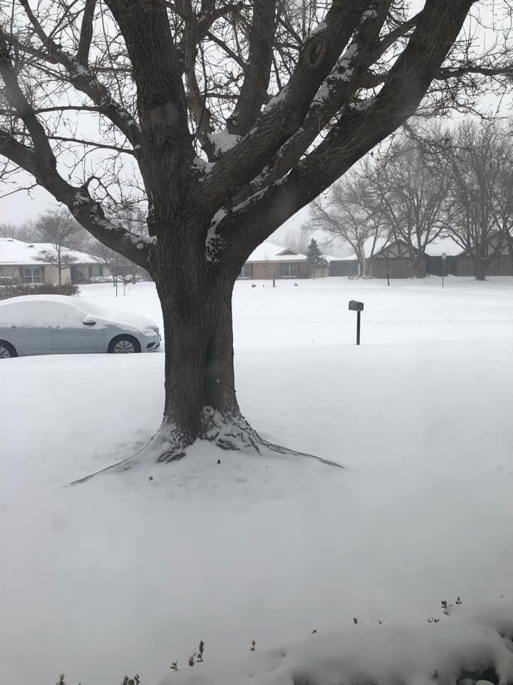
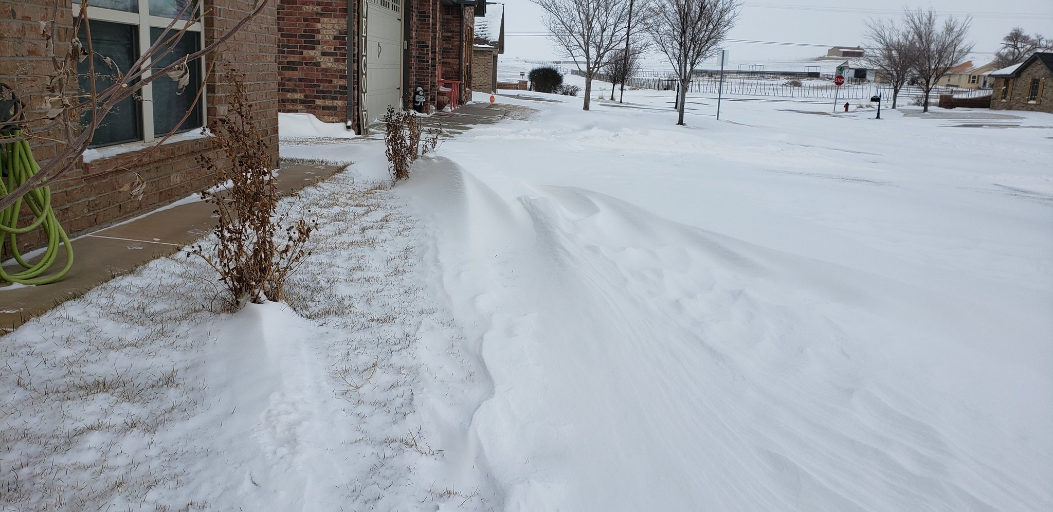
| Snowy neighborhood in Amarillo (Dawn Phinney Johnston) |
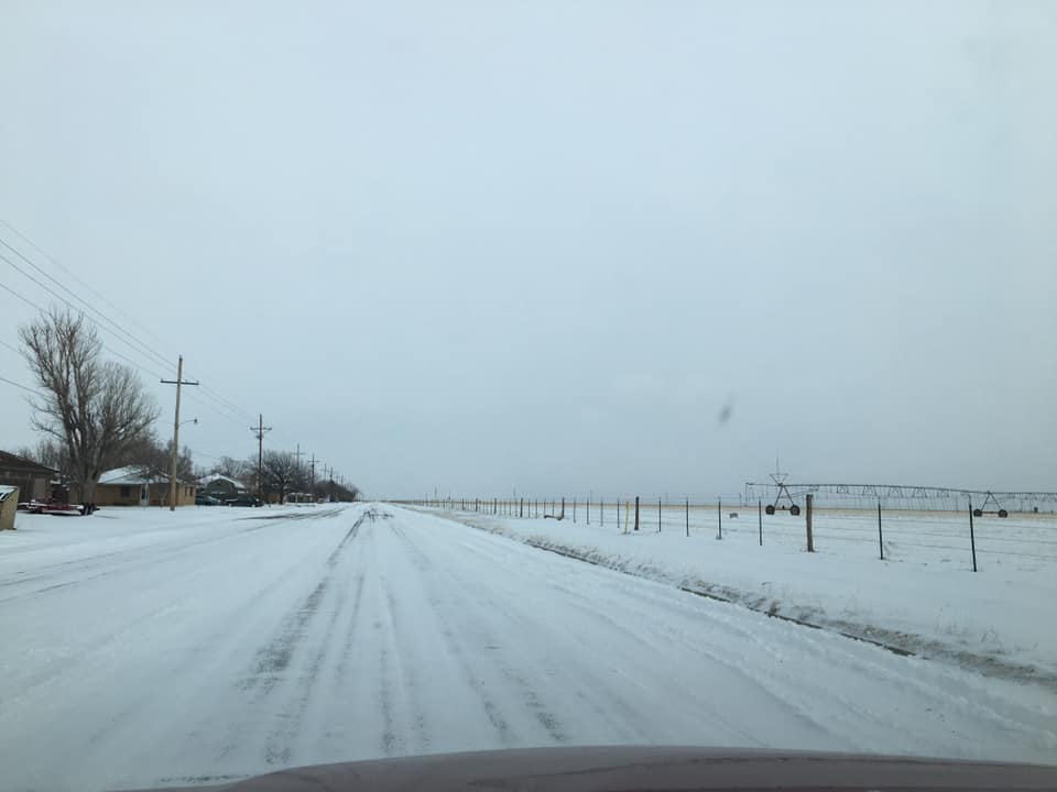
Snow covered roads in Dumas (Martha Granados) |
Snowy neighborhood in Borger (Mary Bobledo) |
Snowy backyard in Dumas (Miriam Contreras) |
 |
|||
| Large snow drift in Canyon (Aaron Ward) |
Storm Reports
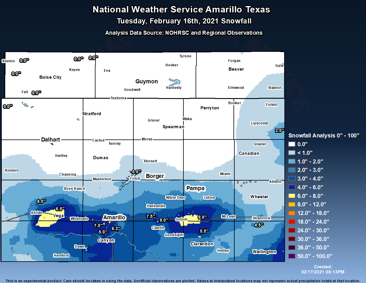
The map below represents an interpolation of snow reports received covering Sunday, February 14th, 2021 snow event. It includes snowfall from Sunday ONLY and is not a map of overall snow depth, which is a combination of snow from both Sunday and Tuesday.

Snow totals across the Panhandles ranged from 1 to 6.5 inches, with most places receiving between 3 and 5 inches of snow.
...SNOWFALL REPORTS FROM SUNDAY FEBRUARY 14TH...

LOCATION                     AMOUNT    TIME/DATE       PROVIDER
1 NNE DALHART                6.5 IN    1140 AM 02/14   PUBLIC
5 NW CANYON                  6.0 IN    1236 PM 02/14   NWS EMPLOYEE
HEREFORD                     6.0 IN    1208 PM 02/14   PUBLIC
3 E CANYON                   5.7 IN    0140 PM 02/14   NWS EMPLOYEE
DALHART                      5.2 IN    0630 AM 02/14   COOP
4 SSW AMARILLO               5.0 IN    0425 PM 02/14   NWS EMPLOYEE
5 SSW AMARILLO               5.0 IN    1244 PM 02/14   PUBLIC
6 ENE AMARILLO               5.0 IN    1155 AM 02/14   OFFICIAL NWS OBS
STINNETT                     5.0 IN    0920 AM 02/14   PUBLIC
FELT 2.8 ESE                 5.0 IN    0800 AM 02/14   COCORAHS
HARTLEY                      5.0 IN    0755 AM 02/14   PUBLIC
7 SW AMARILLO                4.8 IN    0510 PM 02/14   NWS EMPLOYEE
6 W AMARILLO                 4.5 IN    0100 PM 02/14   NWS EMPLOYEE
PAMPA                        4.5 IN    1125 AM 02/14   EMERGENCY MNGR
SPEARMAN                     4.0 IN    0153 PM 02/14   LAW ENFORCEMENT
5 SW AMARILLO                4.0 IN    1231 PM 02/14   BROADCAST MEDIA
1 N MIAMI                    4.0 IN    1145 AM 02/14   LAW ENFORCEMENT
1 S CANYON                   4.0 IN    1000 AM 02/14   COCORAHS
AMARILLO 5.0 W               4.0 IN    0900 AM 02/14   COCORAHS
1 W BUSHLAND                 4.0 IN    0830 AM 02/14   CO-OP OBSERVER
4 N DUMAS                    4.0 IN    0822 AM 02/14   PUBLIC
2 ENE HEREFORD               4.0 IN    0700 AM 02/14   COCORAHS
1 SSE STRATFORD              4.0 IN    0700 AM 02/14   COCORAHS
GRUVER                       4.0 IN    0700 AM 02/14   CO-OP OBSERVER
DAWN                         4.0 IN    0518 AM 02/14   TRAINED SPOTTER
1 SSW PERRYTON               3.9 IN    0700 AM 02/14   COCORAHS
5 E FRITCH                   3.6 IN    0700 AM 02/14   COCORAHS
1 N HEREFORD                 3.6 IN    0630 AM 02/14   COCORAHS
4 WSW AMARILLO               3.5 IN    0158 PM 02/14   BROADCAST MEDIA
WHEELER                      3.5 IN    1132 AM 02/14   LAW ENFORCEMENT
CLARENDON                    3.5 IN    1113 AM 02/14   PUBLIC
LAKE TANGLEWOOD              3.5 IN    1100 AM 02/14   NWS EMPLOYEE
TEXLINE                      3.5 IN    0700 AM 02/14   COCORAHS
3 NW VEGA                    3.5 IN    0700 AM 02/14   CO-OP OBSERVER
6 NW TIMBERCREEK CANYON      3.0 IN    1158 AM 02/14   PUBLIC
1 NNE CANADIAN               3.0 IN    1137 AM 02/14   LAW ENFORCEMENT
BOISE CITY                   3.0 IN    1112 AM 02/14   PUBLIC
1 NNW FRITCH                 3.0 IN    0910 AM 02/14   PUBLIC
VEGA                         3.0 IN    0903 AM 02/14   PUBLIC
BORGER                       3.0 IN    0900 AM 02/14   PUBLIC
6 ENE AMARILLO               3.0 IN    0600 AM 02/14   OFFICIAL NWS OBS
GUYMON                       2.8 IN    1003 AM 02/14   LAW ENFORCEMENT
BEAVER                       2.5 IN    1028 AM 02/14   EMERGENCY MNGR
1 WSW AMARILLO               2.5 IN    1018 AM 02/14   BROADCAST MEDIA
WELLINGTON                   2.5 IN    1014 AM 02/14   LAW ENFORCEMENT
6 WSW AMARILLO               2.5 IN    0615 AM 02/14   COCORAHS
BOOKER                       2.0 IN    1011 AM 02/14   EMERGENCY MNGR
CANADIAN                     2.0 IN    0952 AM 02/14   PUBLIC
PANHANDLE                    2.0 IN    0928 AM 02/14   LAW ENFORCEMENT
8 N FLORIS                   2.0 IN    0700 AM 02/14   COCORAHS
CLAUDE                       1.5 IN    0937 AM 02/14   LAW ENFORCEMENT
1 W SANFORD                  1.5 IN    0600 AM 02/14   CO-OP OBSERVER
PAMPA                        1.3 IN    0630 AM 02/14   CO-OP OBSERVER
LIPSCOMB                     1.0 IN    0700 AM 02/14   CO-OP OBSERVER

OBSERVATIONS ARE COLLECTED FROM A VARIETY OF SOURCES WITH VARYING
EQUIPMENT AND EXPOSURES. WE THANK ALL VOLUNTEER WEATHER OBSERVERS
FOR THEIR DEDICATION. NOT ALL DATA LISTED ARE CONSIDERED OFFICIAL.
Record Cold
While much of the area was below freezing for over a week, the coldest days were February 14th - February 16th. On the 14th, the daytime high temperature in Amarillo was only 3 degrees. The frigid temperatures combined with a 15 to 25 mph wind resulted in wind chill values around -15 to -25 degrees (some locations even hit 30 below zero). On the night of the 14th into the morning hours on the 15th, winds let up some as the arctic high pressure settled over the area. The ambient temperatures bottomed out that night, with Amarillo falling to 11 below zero. The coldest location fell to 22 below zero (Boise City, OK). In the Texas Panhandle, the coldest was 20 below zero at Palo Duro Reservoir. While not quite as cold, temperatures still fell below zero once again on the night of the 15th into the early morning hours on the 16th.
Here's a cool #science experiment. We tossed boiling water into the 2°F air, which quickly condensed into a cloud. *Disclaimer: Don't throw boiling water at yourself or anyone around you, and don't waste coffee. #txwx #Amarillo #Texas #arcticblast pic.twitter.com/LN6s9us9ts
— NWS Amarillo (@NWSAmarillo) February 14, 2021
It's not every day you see frozen lakes in Texas! This is Lake Tanglewood, southeast of Amarillo, on the morning of Feb 15. #phwx #txwx #arcticblast pic.twitter.com/DS4mkWR3yl
— NWS Amarillo (@NWSAmarillo) February 16, 2021
Storm Reports
This is a map of the coldest air temperatures measured on the 15th and 16th. For wind chills, please scroll down.

...MINIMUM WIND CHILLS THE MORNING OF SUNDAY FEBRUARY 14TH...

Location                     WC Temp.  Time/Date       Provider
4.7 NE Hooker (UPR)          -29 F     0745 AM 02/14   MESOWEST
Stinnett 1NNW                -27 F     0947 AM 02/14   WT-MESO
Palo Duro Reservoir 1NW      -27 F     0849 AM 02/14   WT-MESO
Lake McClellan 2NW           -27 F     1055 AM 02/14   WT-MESO
Umbarger 3NNE                -27 F     1115 AM 02/14   WT-MESO
Adrian 6WSW                  -26 F     1056 AM 02/14   WT-MESO
Bootleg 11WNW                -26 F     1007 AM 02/14   WT-MESO
Amarillo 7SSE                -26 F     1048 AM 02/14   WT-MESO
Goodnight                    -26 F     0924 AM 02/14   WT-MESO
9 E Sedan                    -26 F     1150 AM 02/14   AWS
Panhandle 1SSW               -26 F     1124 AM 02/14   WT-MESO
Texhoma (UPR)                -26 F     0910 AM 02/14   MESOWEST
Romero 11SSW                 -25 F     1058 AM 02/14   WT-MESO
Claude 12SW                  -25 F     1112 AM 02/14   WT-MESO
Amarillo (ASOS)              -25 F     1004 AM 02/14   ASOS
Amarillo: Amarillo Internati -25 F     1004 AM 02/14   MESOWEST
Major Samuel B Cornelius Fie -25 F     0915 AM 02/14   MESOWEST
Fritch 1WNW                  -24 F     0901 AM 02/14   WT-MESO
Canadian 6E                  -24 F     0820 AM 02/14   WT-MESO
Amarillo 15NNW               -24 F     0924 AM 02/14   WT-MESO
Dumas (AWOS)                 -24 F     0915 AM 02/14   AWOS
8.8 SW Dalhart (UPR)         -24 F     0850 AM 02/14   MESOWEST
Amarillo 9NNE                -23 F     0935 AM 02/14   WT-MESO
2.7 SW Bushland (SCAN)       -23 F     1100 AM 02/14   MESOWEST
13.3 S Goodnight (DTN)       -23 F     1045 AM 02/14   MESOWEST
Dalhart                      -23 F     0917 AM 02/14   CWOP
Hooker                       -23 F     0750 AM 02/14   OK-MESO
Kenton                       -23 F     0620 AM 02/14   OK-MESO
4.3 NE Stratford (UPR)       -23 F     0925 AM 02/14   MESOWEST
Palo Duro Canyon SP RIM      -22 F     0941 AM 02/14   WT-MESO
6.5 NW Howardwick (DTN)      -22 F     1115 AM 02/14   MESOWEST
Amarillo (CWOP)              -22 F     1016 AM 02/14   CWOP
Hereford E (CWOP)            -22 F     1104 AM 02/14   CWOP
Dalhart                      -22 F     1020 AM 02/14   CWOP
Borger                       -22 F     0931 AM 02/14   CWOP
Goodwell                     -22 F     1050 AM 02/14   OK-MESO
Dalhart (ASOS)               -22 F     0844 AM 02/14   ASOS
Dalhart: Dalhart Municipal A -22 F     1215 PM 02/14   MESOWEST
4.1 NE Conlen (UPR)          -22 F     0945 AM 02/14   MESOWEST
Palo Duro 4E (JA Ranch)      -21 F     0945 AM 02/14   WT-MESO
12 SW Ware                   -21 F     0910 AM 02/14   AWS
Dozier 3W                    -21 F     1022 AM 02/14   WT-MESO
Bootleg (RAWS)               -21 F     1003 AM 02/14   RAWS
Boise City                   -21 F     0120 PM 02/14   OK-MESO
Texline                      -21 F     1045 AM 02/14   CWOP
7.3 W Lake Meredith (DTN)    -21 F     1045 AM 02/14   MESOWEST
3.6 NW Lake Meredith (DTN)   -21 F     1000 AM 02/14   MESOWEST
Borger: Hutchinson County Ai -21 F     0940 AM 02/14   MESOWEST
Perryton (AWOS)              -21 F     0755 AM 02/14   AWOS
Beaver                       -20 F     0620 AM 02/14   OK-MESO
9.8 S Alanreed (DTN)         -20 F     1100 AM 02/14   MESOWEST
8.9 E Pringle (DTN)          -20 F     1000 AM 02/14   MESOWEST
Guymon  Guymon Municipal Air -20 F     1020 AM 02/14   MESOWEST
Canadian (AWOS)              -20 F     0855 AM 02/14   AWOS
Boys Ranch 1WSW              -19 F     1133 AM 02/14   WT-MESO
7.1 E Stinnett (DTN)         -19 F     1100 AM 02/14   MESOWEST
Dalhart                      -19 F     1033 AM 02/14   CWOP
Borger (ASOS)                -19 F     0948 AM 02/14   ASOS
Mesa Vista Ranch (AWOS)      -19 F     0935 AM 02/14   AWOS
Guymon (ASOS)                -19 F     0853 AM 02/14   ASOS
Hereford (AWOS)              -19 F     1115 AM 02/14   AWOS
9.3 NE Dalhart (UPR)         -19 F     1040 AM 02/14   MESOWEST
Hereford S (CWOP)            -18 F     1059 AM 02/14   CWOP
Dalhart (CWOP)               -18 F     0546 AM 02/14   CWOP
4.0 NE Goodwell (UPR)        -18 F     0740 AM 02/14   MESOWEST
1.9 SW Optima (UPR)          -18 F     0820 AM 02/14   MESOWEST
Wheeler Raws                 -18 F     0852 AM 02/14   RAWS
Amarillo                     -17 F     1127 AM 02/14   CWOP
Palo Duro Canyon SP Floor    -16 F     0706 AM 02/14   WT-MESO
Cedar (RAWS)                 -16 F     0935 AM 02/14   RAWS
Amarillo                     -16 F     0902 AM 02/14   CWOP
Borger                       -16 F     1000 AM 02/14   CWOP
8.4 NE Romero (UPR)          -15 F     0100 PM 02/14   MESOWEST
8.2 N Hedley (DTN)           -14 F     1000 AM 02/14   MESOWEST
Downtown Amarillo (CWOP)     -14 F     1057 AM 02/14   CWOP
Hereford NW (CWOP)           -14 F     1239 PM 02/14   CWOP
Perryton                     -11 F     0317 AM 02/14   CWOP
5.7 NE Nara Visa (UPR)        -9 F     1010 AM 02/14   MESOWEST
Snow Round 2: February 16th
Another storm system came across the area on February 16th. This one was a bit more challenging to forecast due to uncertainty with a very narrow band of snow. This band ended up forming over I-40, and produced anywhere from 5 to 9 inches from Vega to Shamrock. NWS Amarillo measured 7.4 inches total snow for this event.
Snow will continue to move to the east northeast across the southern Texas Panhandle. Most of the snow will stay along and south of the Canadian River #phwx #okwx #txwx pic.twitter.com/LDfcMkQjIQ
— NWS Amarillo (@NWSAmarillo) February 16, 2021
At 725 pm we remained in the heaviest snow band at the office in #Amarillo and were pushing 6” of snow. Most of this occurred in 3 hours. We strongly recommend folks stay home this evening until the heavy band moves away. #phwx #txwx pic.twitter.com/cdurMTCM1W
— NWS Amarillo (@NWSAmarillo) February 17, 2021
Photos & Video
 |
 |
||
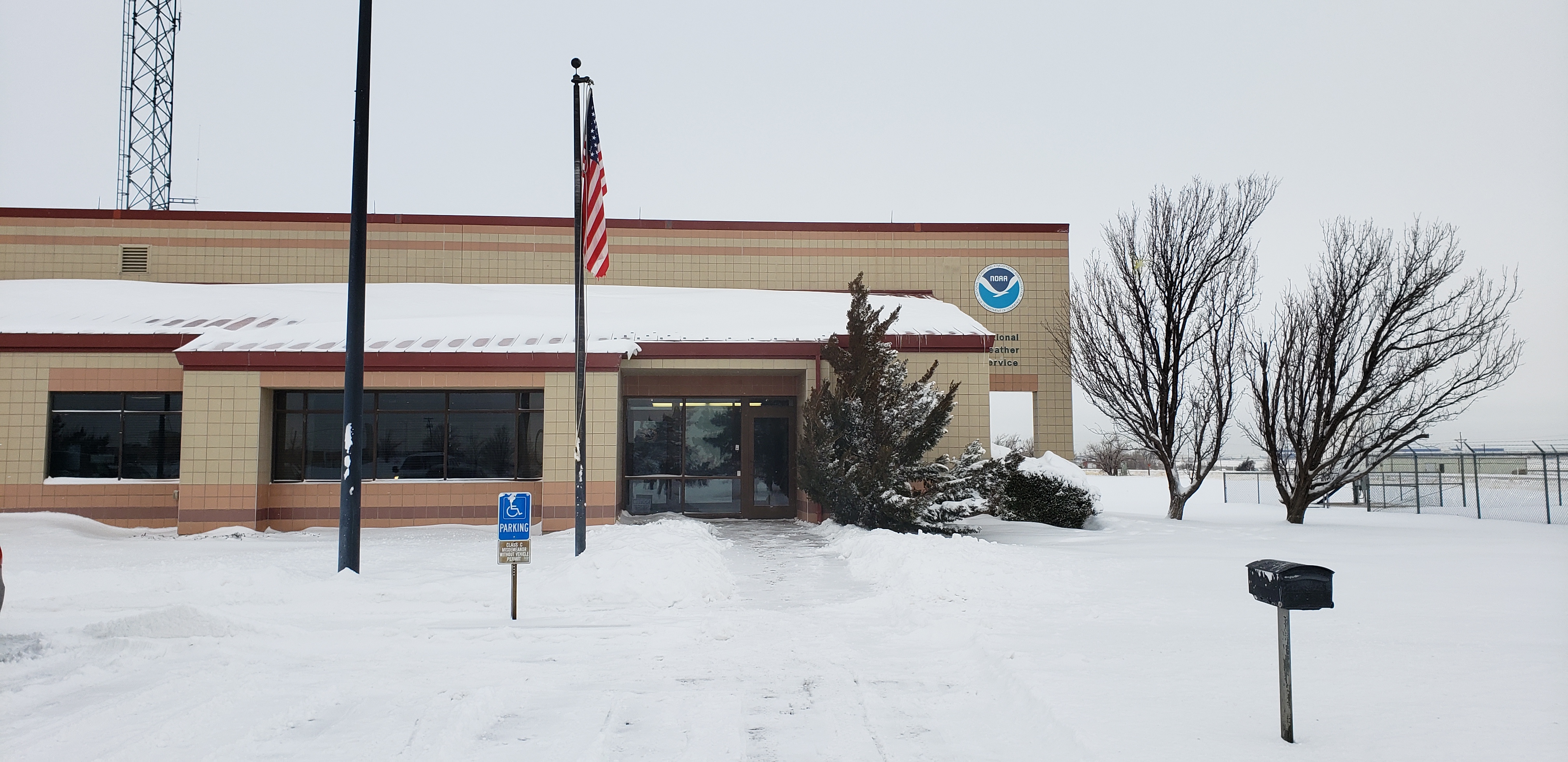
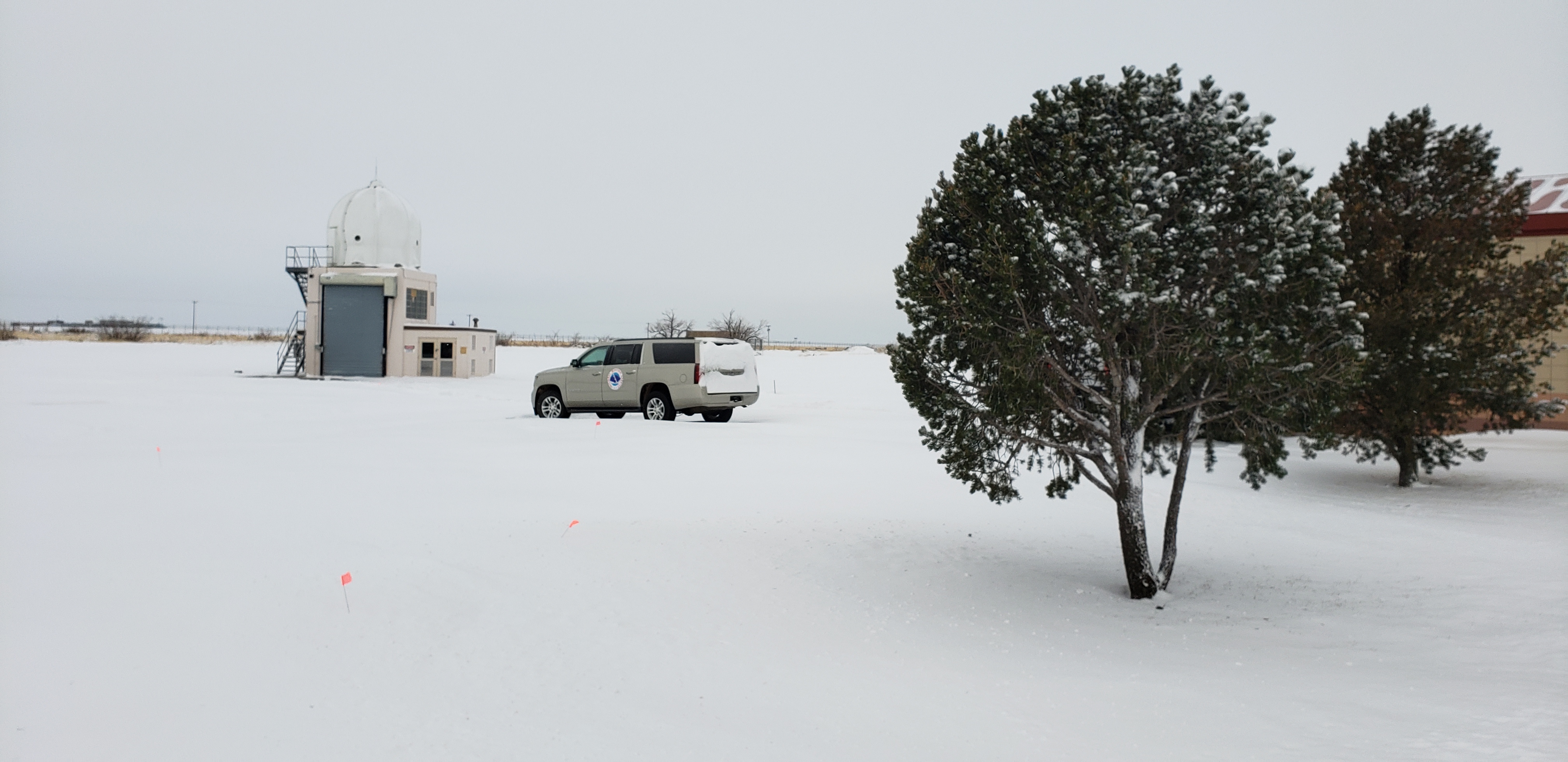
| Snow at NWS Amarillo (Aaron Ward) |
Snow at NWS Amarillo (Aaron Ward) |
Storm Reports
The map below represents an interpolation of snow reports received covering the Tuesday, February 16th, 2021 snow event. It includes snowfall from TUESDAY ONLY and is not a map of overall snow depth, which is a combination of snow from both Sunday and Tuesday.
...SNOWFALL REPORTS FROM THE TUESDAY FEBRUARY 16TH 2021 SNOW EVENT...

LOCATION                     AMOUNT    TIME/DATE       PROVIDER
5 N CLAUDE                   9.0 IN    0930 PM 02/16   PUBLIC
GROOM                        9.0 IN    0720 AM 02/17   CO-OP OBSERVER
4 WSW LAKE MCCLELLAN         9.0 IN    0747 AM 02/17   CO-OP OBSERVER
3 WSW AMARILLO               7.5 IN    0950 PM 02/16   PUBLIC
5 W AMARILLO                 7.5 IN    0921 PM 02/16   PUBLIC
8 N CLAUDE                   7.5 IN    1017 PM 02/16   TRAINED SPOTTER
6 ENE AMARILLO               7.4 IN    1223 AM 02/17   OFFICIAL NWS OBS
BUSHLAND                     7.3 IN    0937 PM 02/16   TRAINED SPOTTER
7 ESE BUSHLAND               7.0 IN    1014 PM 02/16   PUBLIC
1 S CANYON                   7.0 IN    0800 AM 02/17   COCORAHS
SHAMROCK                     7.0 IN    0700 AM 02/17   TRAINED SPOTTER
4 WSW AMARILLO               6.8 IN    1003 PM 02/16   PUBLIC
CANYON                       6.5 IN    1024 PM 02/16   PUBLIC
3 NW VEGA                    6.5 IN    0700 AM 02/17   CO-OP OBSERVER
5 SSW AMARILLO               6.3 IN    0933 PM 02/16   NWS EMPLOYEE
WELLINGTON                   6.3 IN    0815 AM 02/17   PUBLIC
CANYON                       6.1 IN    0630 AM 02/17   NWS EMPLOYEE
3 W AMARILLO                 6.0 IN    0928 PM 02/16   PUBLIC
6 SSW AMARILLO               6.0 IN    0925 PM 02/16   PUBLIC
CLARENDON                    6.0 IN    0700 AM 02/17   LAW ENFORCEMENT
8 SW AMARILLO                6.0 IN    1000 PM 02/16   PUBLIC
2 NNE AMARILLO               5.6 IN    0740 PM 02/16   PUBLIC
6 WSW AMARILLO               5.5 IN    0600 AM 02/17   COCORAHS
4 SSW AMARILLO               5.5 IN    0802 PM 02/16   NWS EMPLOYEE
HOWARDWICK                   5.5 IN    0800 AM 02/17   TRAINED SPOTTER
1 SW CANYON                  5.0 IN    0930 PM 02/16   PUBLIC
3 N CANYON                   5.0 IN    0914 PM 02/16   PUBLIC
CLAUDE                       4.5 IN    0735 PM 02/16   LAW ENFORCEMENT
4 N DOZIER                   4.5 IN    0600 AM 02/17   TRAINED SPOTTER
PANHANDLE                    4.0 IN    0705 PM 02/16   PUBLIC
PAMPA                        3.9 IN    0700 AM 02/17   CO-OP OBSERVER
ALLISON                      3.7 IN    0631 AM 02/17   TRAINED SPOTTER
2 E LAKE TANGLEWOOD          3.5 IN    0700 AM 02/17   TRAINED SPOTTER
5 NW CANYON                  3.0 IN    0810 PM 02/16   NWS EMPLOYEE
1 N HEREFORD                 2.3 IN    0630 AM 02/17   COCORAHS
2 ENE HEREFORD               2.1 IN    0700 AM 02/17   COCORAHS
1.1 N HIGGINS                2.0 IN    0800 AM 02/17   COOP

OBSERVATIONS ARE COLLECTED FROM A VARIETY OF SOURCES WITH VARYING
EQUIPMENT AND EXPOSURES. WE THANK ALL VOLUNTEER WEATHER OBSERVERS
FOR THEIR DEDICATION. NOT ALL DATA LISTED ARE CONSIDERED OFFICIAL
Climate Fun Facts
Climate Overview
Amarillo, TX had a warm start to February of 2021, along with other areas in the combined Oklahoma and Texas Panhandles, with the first 7 days making it to a high temperature of at least 50 degrees Fahrenheit. In fact, on the third day Amarillo reached a high of 79º F. Overnight lows were only making it down into the 20s through about day 8 of the month.
February 7th, a strong arctic air mass moved into the northeastern combined Panhandles. Beaver, OK would last see temperatures above freezing on February 6th before going into a prolonged freeze event. A cold front moved into the Panhandles bisecting the southwest from the northeast creating quite the temperature difference. Around 2 P.M. CST Sunday the 7th, Beaver, OK was sitting at 26 º F, while Hereford, TX had warmed to 66 º F. Borger, TX which is about halfway between Beaver and Hereford, was at 51 º F by this time. Perryton, TX which is approximately 30 miles to the southwest of Beaver, OK was 34 º F by 2 P.M. The warm air in the southwest would begin to battle over the Panhandles with the cold arctic air to the northeast for several days.
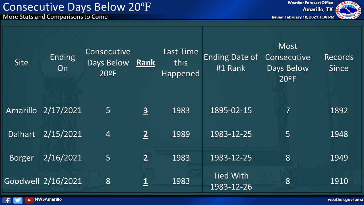
Behind the cold front remained low clouds and moisture that created freezing fog and freezing drizzle across the area starting on the 7th in the northeast but expand as the cold air moved southeast during the hours of darkness. The freezing fog and drizzle created slick driving surfaces and poor visibility to motorists, but it also made for some beautiful winter scenery. Guymon, OK along with much of the northeast half of the combined Panhandles would be stuck under these low clouds and fog deck for days. While Guymon, OK got to 52 on the 7th it only reached a high of 25 º F on Monday the 8th. This was the start of 11 consecutive days that Guymon would be below freezing.
Each day between the 7th and the 11th the warm air would battle over the southwestern combined Panhandles. Those areas that stayed to the northeast of the front would be stuck under overcast skies and sometimes when the fog lifted would get flurries. The cold air won over Amarillo on the 10th with Amarillo’s high temperature only getting to 24º F. The next day on the 11th the warm air took over parts of Amarillo allowing the high to barely squeak above freezing with a high of 33 º F. This would be the last day Amarillo would be above freezing for an extended period. The evening of the 11th the cold air mass finally started taking over much of the southern plains. In fact, it had started to take over the entire state of Texas.
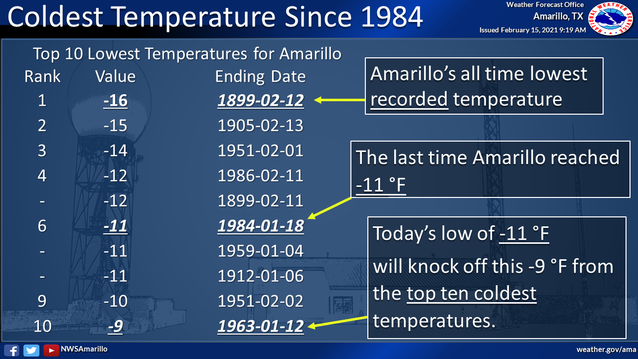
By the 13th, most of the Southern Plains to include a good portion of Texas would be preparing for a strong storm system that would combine moisture with extreme cold to create a winter storm across several thousand miles. Snow began to fall on the evening of the 13th, with more snow and even colder temperatures taking over on Valentine’s Day. Amarillo officially got 0.9 inches of snow on the 13th with an additional 4.1 inches falling on Valentine’s Day. Valentine’s day ended up being so cold that daytime temperatures would not make it out of the single digits across much of the combined Panhandles.
To show how #cold we've been in #Amarillo, #Texas compared to climatology and records, here's a graph showing where we have stood lately. The brown shading is considered the "average" day, and we have been complete below that since February 12th. #ArcticBlast2021 pic.twitter.com/eSfHtX94BK
— NWS Amarillo (@NWSAmarillo) February 17, 2021
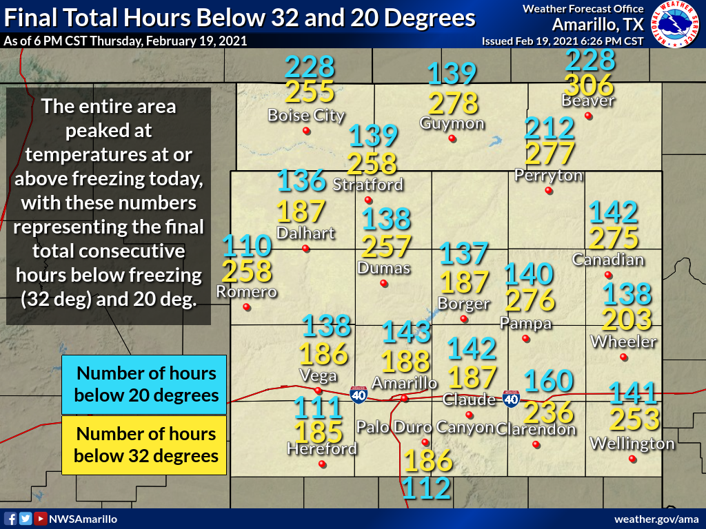
Number of Consecutive Hours Below Freezing and Below 20 Degrees
Fun Climate Statistics
 |
Media use of NWS Web News Stories is encouraged! Please acknowledge the NWS as the source of any news information accessed from this site. |
|

