Dangerous heat will expand from the Gulf Coast into the Southern Plains and Desert Southwest through week's end. Additional extreme heat impacting the Pacific Northwest will shift to the northern Plains by the weekend. Tropical Storm Bertha is expected to continue to impact portions of the northern Gulf Coast from the western Florida Panhandle to southeastern Louisiana through tonight. Read More >
| Damage Surveys |
|
Highly publicized damaging and historic tornado outbreaks in April and June of this year (2011) have led to a substantial increase in public interest in National Weather Service storm surveys. When tornadoes occur, National Weather Service meteorologists are assigned the task of completing a thorough damage survey. A survey team’s mission is to gather data in order to reconstruct a tornado’s life cycle, including where it occurred, when and where it initially touched down and lifted (path length), its width, and its magnitude. It should also be mentioned that survey teams are occasionally tasked with determining whether damage may have been caused by straight line winds or a tornado and assessing the magnitude of straight line winds. With respect to tornado damage surveys, one of the most difficult tasks is assigning a rating to a tornado. Before February 2007, tornado strength was rated based on the Fujita Scale. However, there were some flaws with the original Fujita Scale. For instance, it did not account for the quality of building construction. Beginning in 2001, it was determined that the Fujita Scale needed to be modified, and a committee of meteorologists, engineers, and academia was formed to begin developing a new scale. In February 2007, the new Enhanced Fujita Scale (Table 1) became operational and is still the scale used to rate the magnitude of tornadoes.
|
||||||||||||||||
|
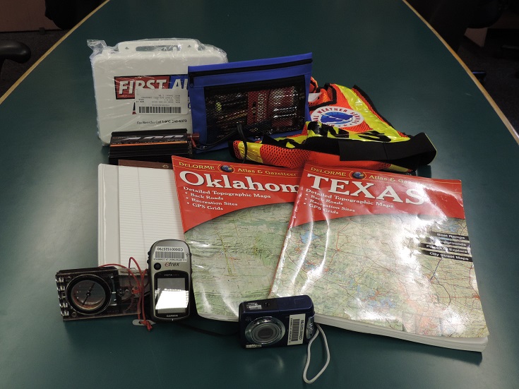
Before a survey team is deployed, they will be equipped with a variety of technology to complete the survey. Typically, a damage survey kit will contain a GPS unit, a cell phone, a laptop with damage survey software, a digital camera, an atlas or gazetteer, and a notebook (Image 1). After a survey team is assigned and the survey kit is prepared, the team then drives to the reported tornado damage location(s). Most commonly, a survey team will conduct a full ground survey in order to assess tornado damage, but occasionally, a team may also conduct an aerial survey if the spatial extent of the damage is large enough.
Depending on the survey team, the starting and ending point of the tornado may be determined first followed by the width of the tornado. The time of the tornado’s life cycle may be confirmed through eyewitness accounts and/or radar data. To determine the magnitude of the tornado, the survey team will attempt to find the worst damage since this is how the tornado will ultimately be rated. Once the worst damage is identified, the survey team will assign a damage indicator to the structure or object. There are 28 damage indicators, including one- or two-family residences, manufactured homes, motels, warehouses, schools, small retail buildings (e.g. fast food restaurants), and even trees. Each one of the damage indicators has a description of the typical construction for that category of indicator. For example, typical construction for one- and two-family residences includes asphalt shingles, tile, slate or metal roofing, attached single car garage, and brick veneer, wood panels, stucco, vinyl or metal siding. Once the structure or object has been assigned a damage indicator, the team will begin a thorough analysis of the building structure and construction. The survey team will then assign a degree of damage to the structure or object. The degree of damage has several different categories, and each category has an expected wind speed and a lower and upper bound wind speed. For one- and two-family residences, if a tornado breaks glass in windows and doors, the expected wind speed is 96 mph, the lower bound wind speed is 79 mph, and the upper bound wind speed is 114 mph. If a tornado produces damage that results in the collapse of all interior and exterior walls, the expected wind speed is 170 mph, the lower bound wind speed is 142 mph, and the upper bound wind speed is 198 mph. This is where the job becomes difficult for the survey team because the team must know some basics about construction. If the quality of construction meets strict building code, the survey team will likely assign an expected wind speed to the damage. If the construction fails to meet code, a lower bound wind speed may be assigned, but if the construction exceeds code and/or is well-engineered, it may be assigned an upper bound wind speed. Once the expected, lower bound, or upper bound wind speed is determined, it is applied to the EF Scale to assign a rating. For more information about the EF Scale, please visit http://www.spc.noaa.gov/efscale |
||