National Weather Service United States Department of Commerce

Extreme Heat and Tropical Storm Bertha Impacts

Dangerous heat will expand from the Gulf Coast into the Southern Plains and Desert Southwest through week's end. Additional extreme heat impacting the Pacific Northwest will shift to the northern Plains by the weekend. Tropical Storm Bertha is expected to continue to impact portions of the northwestern Gulf Coast from south central Louisiana to the upper Texas coast today. Read More >

Texas Panhandle Earthquakes


The Texas Panhandle sees a wide variety of weather throughout the year, but our area is also occasionally shaken by earthquakes.  With respect to earthquake hazards nationally, the Panhandles are in a relatively low threat level compared with locations along the U.S. west coast and the Intermountain West (Figure 1).  Within the state of Texas, the Panhandle is a geographic region with the second highest earthquake risk level (Frohlich et al. 2000).  Although the exact number of earthquakes that have affected the Texas Panhandle is unknown, nearly 91 percent of known Texas Panhandle earthquakes since 1907 have had Richter Scale magnitudes less than 5.0.

United States Geological Survey (USGS) National Seismic Hazard Map.
Figure 1. United States Geological Survey (USGS) National Seismic Hazard Map. Courtesy of the USGS.
Only three known earthquakes have had magnitudes at or above 5.0.  The largest known earthquake in the Texas Panhandle had a Richter Scale magnitude of 5.4 and occurred near Panhandle, TX on 30 July 1925.  No known earthquakes in our area have had a magnitude of 6.0 or greater, but there is no guarantee that has never happened since the seismic record is extremely small.  Frohlich and Davis (2002) estimated that an earthquake with a magnitude greater than 6.0 might occur every 300 years in the Texas Panhandle, which could result in serious damage if it occurred near an inhabited location.  An earthquake with a magnitude between 5.5 and 6.0 is estimated to occur every 50 to 100 years in the Texas Panhandle.


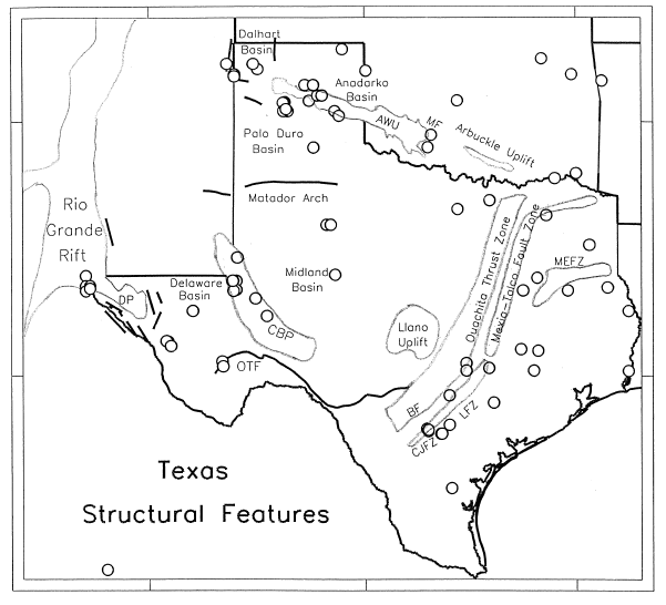
Structural features of Texas.  Lines indicate faults and circles are where earthquakes were felt through 2001.
Figure 2. Structural features of Texas. Lines indicate faults and circles are where earthquakes were felt through 2001. The abbreviation AWU denotes the Amarillo-Wichita Uplift. From Frohlich and Davis (2002).
Most of the earthquakes in the Texas Panhandle occur along the boundary between the Amarillo-Wichita Uplift and the Anadarko Basin system (Figure 2).  This area contains subterranean faults extending from just north of Amarillo into southwestern Oklahoma.  Seismologists and geologists suggest that the earthquakes associated with the Amarillo-Wichita Uplift is of concern because it is geologically similar to the Reelfoot Rift (located in northeastern Arkansas), which has produced historic, powerful earthquakes near New Madrid, Missouri.  However, this is merely speculation since the largest known earthquake in the Texas Panhandle had a magnitude of 5.4.
   
It is also possible that many earthquakes in the Panhandle may not be naturally caused, but rather, they may be the result of petroleum production. In fact, some of the strongest earthquakes in the Panhandle have occurred very close to a large oil and gas field near Panhandle, TX. Controversy does exist with this theory since earthquakes induced by oil field activity usually do not exceed magnitudes of 5.0.  Almost no seismic record exists prior to 1920, around the time when oil and gas production began in the Panhandle. As a result, it is difficult to prove or disprove this theory. Four geographic regions in Texas where earthquakes have been felt through 2001.
Figure 3. Four geographic regions in Texas where earthquakes have been felt through 2001. Symbols indicate whether earthquakes are of natural, man-made, or uncertain origin. Question marks indicate locations of questionable earthquakes. From Frohlich and Davis (2002).
Other earthquakes that have occurred near Dalhart may be associated with a northwestward extension of Amarillo-Wichita Uplift.  These earthquakes likely occur naturally since there are no oil or gas fields in this area (Figure 3).


Texas Panhandle Earthquakes of Richter Scale Magnitude 3 or Higher, 1907-2011
Date Location Richter Scale Magnitude Modified Mercalli Intensity Comments
April 1907 Amarillo 3.6 V Possibly spurious
28 March 1917 Panhandle 3.9 VI  
30 July 1925 All over the Panhandles Strongest 4.2 IV Several foreshocks
30 July 1925 Panhandle 5.4 VI Strongest known earthquake in Texas Panhandle
31 July 1925 White Deer 3.0 III  
19 June 1936 Clarendon 3.0 III  
20 June 1936 Borger 5.0 VI  
20 June 1936 Borger 3.9 III-IV  
20 June 1936 Borger 3.9 III  
12 March 1948 Dalhart 5.2 VI  
20 June 1951 Amarillo 4.2 V  
20 July 1966 Borger 4.1 V  
15 Feb. 1974 Perryton 4.5 V  
9 June 1980 Pampa 4.3 V  
14 Oct. 1982 Dalhart 3.9 III  
7 Nov. 1982 Wheeler County 3.1    
3 April 1984 Oldham County 3.4    
21 May 1984 Oldham County 3.1    
3 March 1986 Oldham County 3.1    
25 March 1996 Channing 3.5    
23 Nov. 1996 McLean 3.0    
12 Feb. 1997 McLean 3.0 IV  
15 Feb. 1997 McLean 3.2 V  
7 August 2000 Amarillo 3.3 III  
7 August 2000 Amarillo 3.0 III  
10 August 2000 Amarillo 3.0 III  
17 August 2000 Amarillo 3.9 V  
16 Dec. 2000 Amarillo 3.9 IV  
24 Sep. 2003 Amarillo 3.3 IV  
17 Feb. 2006 Near Fritch 3.5 III  
12 Oct. 2008 Wheeler County 3.0 III  
13 Oct. 2008 Near Miami 3.7 IV  


References

Frohlich, Cliff, and Scott D. Davis. Texas Earthquakes. Austin: University of Texas Press, 2002.

Frohlich, C., S. D. Davis, and J. Pulliam. 2000. Earthquake hazard identification and risk assessment for Texas: A preliminary analysis of counties at risk. Chapter 12 in Hazard Analysis, Governor’s Division of Emergency Management, Texas Department of Public Safety. Austin.