National Weather Service United States Department of Commerce


Event Summary

Severe weather in the Panhandles is extremely rare in February, much less at night.  In fact, less than 1% of all severe weather in the Panhandles occurs in the month of February.  However, meteorological anomalies do happen, and that is certainly what transpired during the evening and early morning hours of February 2 and 3, respectively.  As a potent upper-level storm system approached the region, abundant moisture from the Gulf of Mexico rapidly streamed northward.  At the surface, a weak semblance of a dry line slowly advanced eastward during the day.  As it encountered the moistening air in the Texas Panhandle, showers and thunderstorms developed by the late afternoon hours.  Initially, this activity remained below severe levels.  However, as the evening progressed, a low-level jet stream continued to pump additional moisture into the area.  This only caused the atmosphere to become more unstable, which caused the thunderstorms to intensify into severe thunderstorms

There were several reports of large hail, including golfball size hail 10 miles north of Amarillo.  Additionally, an EF-1 tornado moved from extreme northeastern Gray County to the far southwestern corner of Hemphill County.  This was the earliest known tornado to occur in the Panhandles and only the fourth known tornado to occur in February in the Amarillo forecast area since 1950!  Despite the severe weather, many locations along and south of the Highway 60 corridor received very beneficial rainfall amounts.  Higgins received 3.19", Allison picked up 2.90", and Canadian received 2.35".
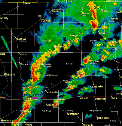
 

Radar loop 6:30 p.m. Feb. 2 - 3:00 a.m. Feb. 3


Storm Surveys
 
Gray/Roberts/Hemphill Counties, TX Survey
BEGIN 10 miles SW of Miami
END 6 miles ESE of Miami
LENGTH 13 miles (sporadic)
WIDTH 100 yards
EF RATING EF-1 (winds 100 mph)
Survey Map


The National Weather Service in Amarillo has completed a damage assessment from a rare February EF-1 tornado in extreme northeastern Gray, far southeastern Roberts, and far southwestern Hemphill Counties on February 3.  The tornado first touched down at a feed lot on State Highway 152 at 12:42 a.m. CST.  The tornado was on the ground for 13 miles with a maximum width of 100 yards.  The tornado dissipated at 1:03 a.m. CST in extreme southwestern Hemphill County.  Damage was observed sporadically along the 13-mile path, suggesting that this tornado was not necessarily on the ground the entire time.

At the beginning of the tornado track, there was a horse barn damaged as well as an overturned center pivot irrigation system.  Two miles to the northeast, two additional center pivot irrigation systems were twisted and overturned.  An additional two miles to the northeast, two single power lines were snapped at the base as well as some farm equppment was strewn across farm fields.  Winds were estimated at 100 mph with the tornado.  The most extreme damage was snapped power poles.

There were no reported injuries or fatalities.  This is a preliminary report and is subject to revision based on any new or additional information.


storm reports
February 2, 2012 Storm Reports
Feb. 2-3 Rainfall
February 2-3 Rainfall Estimates