
Record setting heat is expected over the next several days from the Intermountain West through the northern Plains. Furthermore, fire weather concerns increase with dry and breezy conditions. Meanwhile, heavy rainfall and severe thunderstorm threats for the Ohio/Tennessee Valleys, central Appalachians and Southeast today. The threat shifts to central Gulf Coast and across central Texas this week. Read More >
Overview
During the afternoon of the 24th of June a few thunderstorms had popped up along the HWY 60 corridor. Later in the evening thunderstorms moved into the combined Oklahoma and Texas Panhandles from New Mexico. These storms lined out from I-40 near Endee, NM and ran northeast to around Texline. As this SW to NE oriented line of storms moved east the storms in the north ran into a better environment for the potential to become strong to severe, and did become severe with wind gusts of 70 mph measured at a mesonet site near Palo Duro Reservoir. As this storm approached Perryton around 9 PM CDT one of the storms started to rotate, enabling hail growth and strong winds. Hail was reported north of Perryton up to the size of ping pong balls which combined with strong winds to damage some windows on a farmhouse along with other damage around the property. As this storm moved northeast it created winds estimated at 85 mph, damaging several power distribution poles from Balko to Elmwood, OK, leaving much of Beaver County without power. This storm quickly weakened not long after causing the power loss.
For June 25th, during the afternoon hours of peak heating, thunderstorms formed along a boundary from Endee, NM to Amarillo and from Amarillo up to Canadian. Also some thunderstorms formed in SE CO and eventually traveled along the northern edge of the OK Panhandle from west to east. The environment was primed for strong damaging winds and large hail. Automated weather equipment located throughout both the OK and TX Panhandles measured wind gusts from these storms at well over 60 mph. The highest wind gust measured was 85 mph at the mesonet site near Hooker, Oklahoma. Some thunderstorm wind damage was also reported, especially in Texas County, Oklahoma. The largest hail stone reported was 2 inches in diameter near Clarendon, TX.
Photos & Video
Header
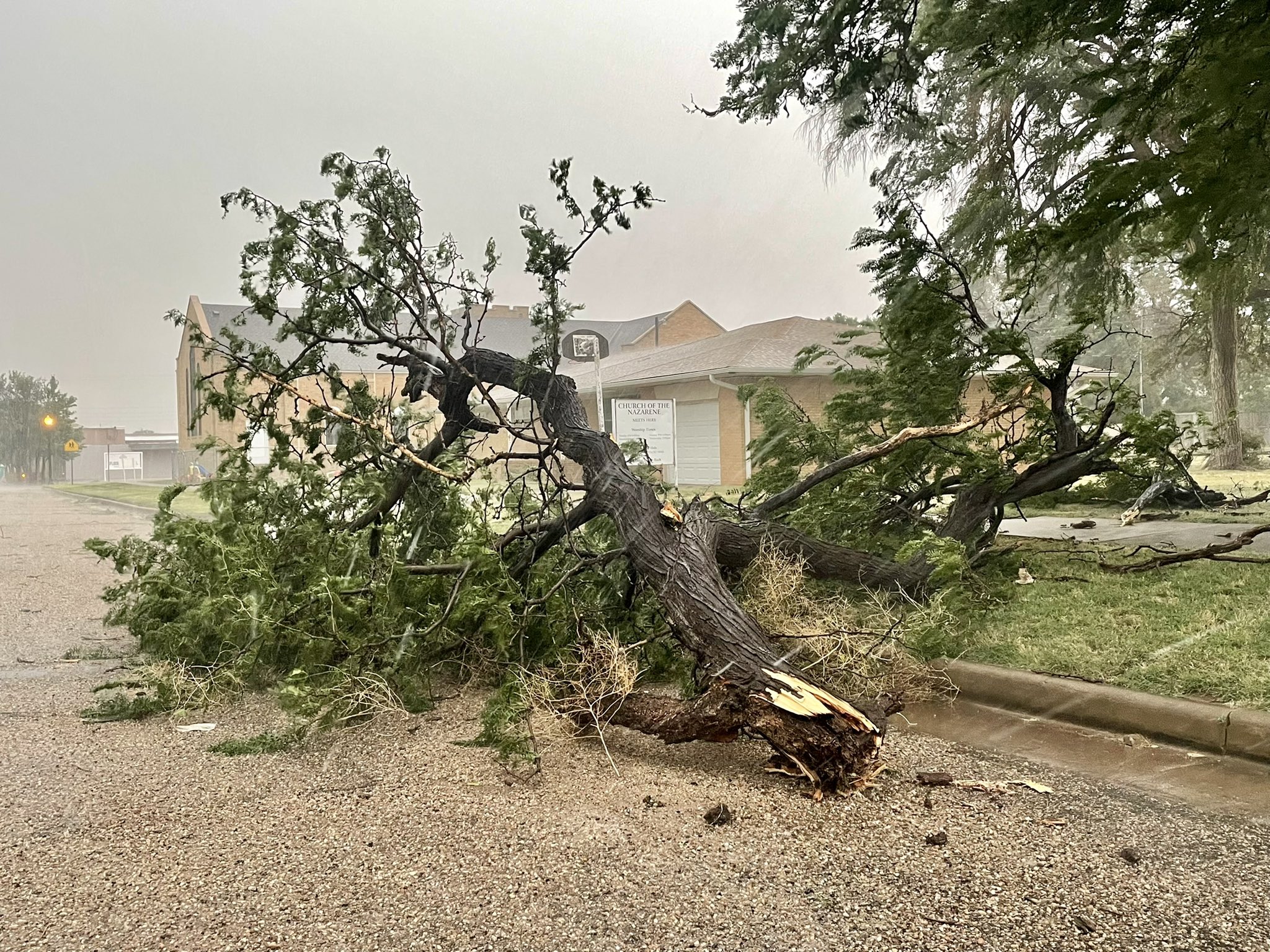 |
| Tree destroyed in Hooker on June 25th (Chad Casey) |
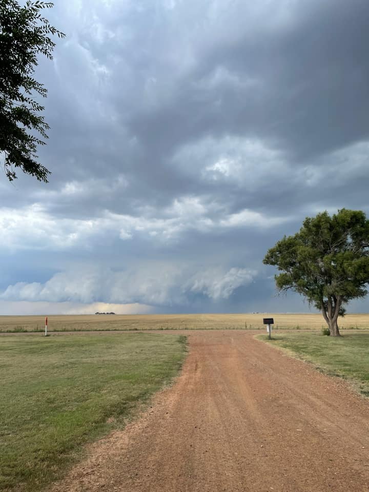 |
| Shelf cloud northwest of Hooker on June 25th. (Erin Fayard Moore) |
Radar
Header
| Radar loop with warnings from June 24th, 2021 | Radar loop with warnings from June 25th, 2021 |
| Loop of reflectivity (left) and velocity (right) data from the Perryton to Beaver County wind damage producing storm on June 24th, 2021. These data are from the Amarillo radar. | Loop of reflectivity (left) and velocity (right) data from the Perryton to Beaver County wind damage producing storm on June 24th, 2021. These data are from the Dodge City radar. |
Storm Reports
 |
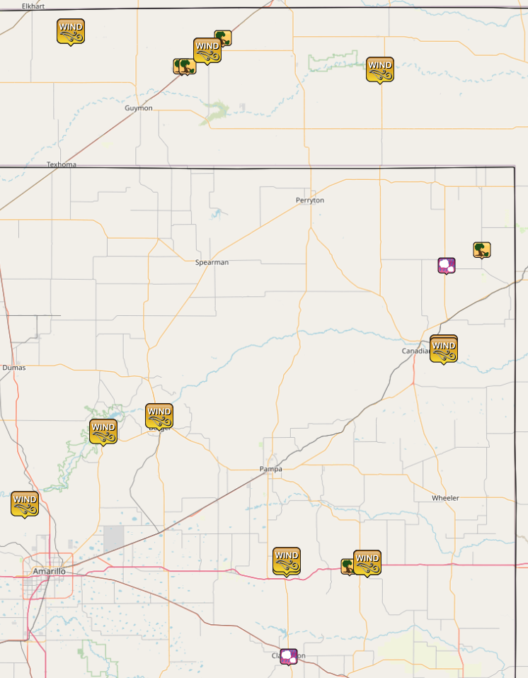 |
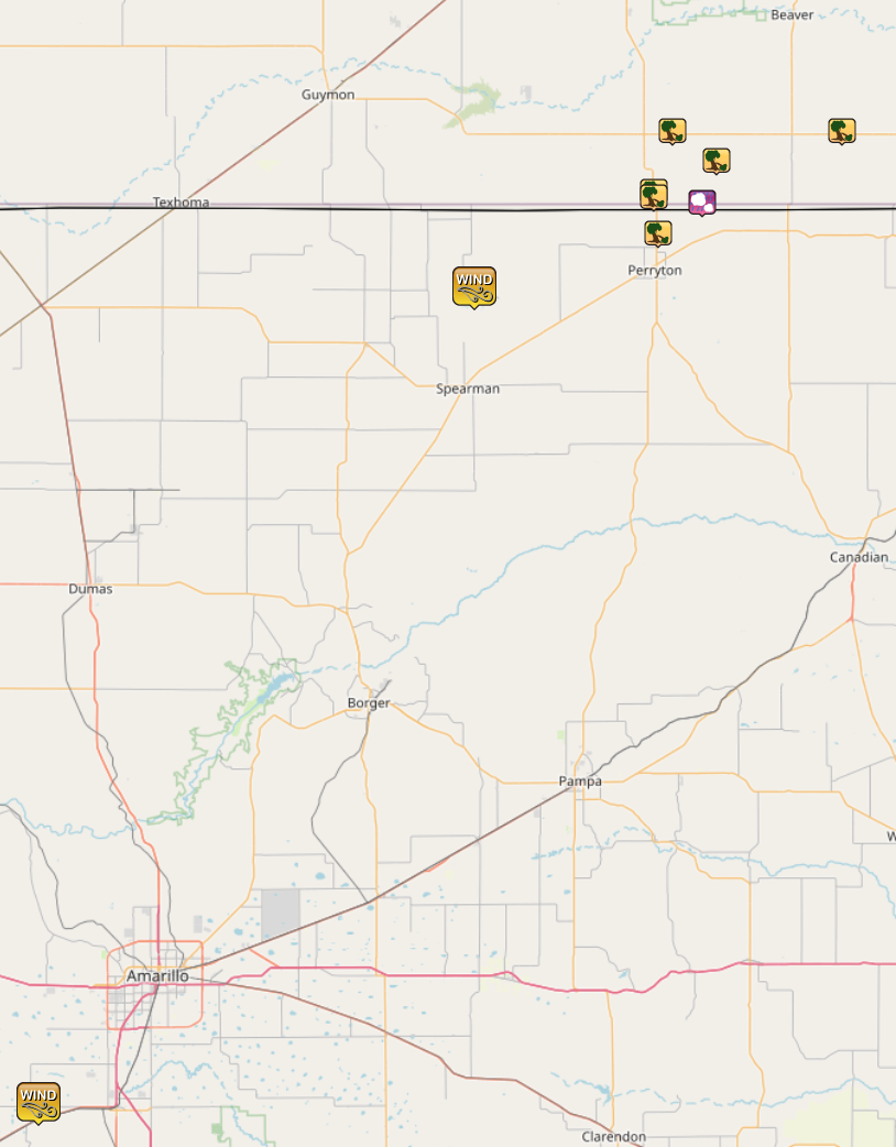
| Map of reports from Thursday, June 24th, 2021 | Map of reports from Friday, Just 25th, 2021 |
| Report Time (CDT) | County | Location | State | Event Type | Magnitude | Source | Lat | Lon | Remark |
| 2021/06/24 20:42 | HANSFORD | 9 NW WAKA | TX | TSTM WND GST | 70 mph | MESONET | 36.36 | -101.18 | PALO DURO RESSERVOIR. |
| 2021/06/24 21:15 | OCHILTREE | 4 N PERRYTON | TX | TSTM WND DMG | PUBLIC | 36.45 | -100.8 | SHERIFF CALLED AND REPORTED THAT A BARN HAD BEEN DESTROYED ABOUT 4 MILES NORTH OF PERRYTON, THERE WERE POWERLINES THAT HAD BEEN SNAPPED, AND TREES DOWN. TIME IS ESTIMATED BY RADAR. | |
| 2021/06/24 21:18 | BEAVER | 2 SSE GRAY | OK | TSTM WND DMG | LAW ENFORCEMENT | 36.52 | -100.81 | SEMI BLOWN OVER ON U.S. HIGHWAY 83 BY THUNDERSTORM WIND GUST. | |
| 2021/06/24 21:18 | BEAVER | 3 SSE GRAY | OK | TSTM WND DMG | LAW ENFORCEMENT | 36.51 | -100.81 | CORRECTS PREVIOUS TSTM WND DMG REPORT FROM 3 SSE GRAY. OCHILTREE SHERRIFF REPORTED THAT TREES WERE BLOWN DOWN AT THE STATE LINE. | |
| 2021/06/24 21:24 | BEAVER | 4 S BALKO | OK | TSTM WND DMG | PUBLIC | 36.57 | -100.68 | ONE POWER POLE BLOWN DOWN BY THUNDERSTORM WIND GUST. | |
| 2021/06/24 21:25 | OCHILTREE | 9 NE PERRYTON | TX | HAIL | 1.5" | PUBLIC | 36.5 | -100.71 | PERSON REPORTED BROKEN WINDOWS TO HOUSE FROM LARGE HAIL BLOWING IN FROM THE WEST. THE LARGEST HAIL WAS PING PONG BALL SIZE WITH LOTS OF QUARTERS. VEHICLES RECEIVED DENTS AND TREE LIMBS UP TO 4 INCHES IN DIAMETER WERE BLOWN/KNOCKED DOWN. |
| 2021/06/24 21:28 | RANDALL | 3 NNE UMBARGER | TX | TSTM WND GST | 58 mph | MESONET | 34.99 | -102.08 | WEST TEXAS MESONET UMBARGER 3NNE MEASURED 58 MPH WIND GUST. |
| 2021/06/24 21:35 | BEAVER | 3 E BRYANS CORNER | OK | TSTM WND DMG | UTILITY COMPANY | 36.62 | -100.77 | POWER COMPANY IS REPORTING 46 TRANSMISSION POLES (65 FOOT), AND 50-60 DISTRIBUTION POLES (35 FOOT) TAKEN OUT BETWEEN BALKO AND ELMWOOD, OKLAHOMA. WINDS ARE ESTIMATED BY DAMAGE TO BE BETWEEN 85 AND 95 MPH. | |
| 2021/06/24 21:50 | BEAVER | 6 E ELMWOOD | OK | TSTM WND DMG | EMERGENCY MNGR | 36.62 | -100.42 | SEMI TRUCK BLOWN OFF ROAD AND 5 POWER POLES DOWNED. TIME ESTIMATED FROM RADAR. | |
| 2021/06/25 15:48 | LIPSCOMB | 8 E LIPSCOMB | TX | TSTM WND DMG | LAW ENFORCEMENT | 36.23 | -100.13 | TREE DOWN IN THE ROAD. | |
| 2021/06/25 16:30 | POTTER | 15 NNW AMARILLO | TX | TSTM WND GST | 60 mph | MESONET | 35.42 | -101.93 | WEST TEXAS MESONET STATION 15 NNW AMARILLO. |
| 2021/06/25 17:03 | MOORE | 2 WNW FRITCH | TX | TSTM WND GST | 58 mph | MESONET | 35.65 | -101.62 | WEST TEXAS MESONET STATION FRITCH 1WNW. |
| 2021/06/25 17:09 | HEMPHILL | 6 E CANADIAN | TX | TSTM WND GST | 58 mph | MESONET | 35.92 | -100.28 | WEST TEXAS MESONET STATION CANADIAN 6E. |
| 2021/06/25 17:26 | HUTCHINSON | 3 N BORGER | TX | TSTM WND GST | 69 mph | ASOS | 35.7 | -101.4 | ASOS STATION KBGD BORGER (ASOS). |
| 2021/06/25 17:30 | TEXAS | 12 NE EVA | OK | TSTM WND GST | 59 mph | MESONET | 36.92 | -101.75 | OKLAHOMA MESONET STATION. |
| 2021/06/25 17:35 | TEXAS | 12 NE EVA | OK | TSTM WND GST | 62 mph | MESONET | 36.92 | -101.75 | OKLAHOMA MESONET STATION. |
| 2021/06/25 18:05 | TEXAS | 4 NE OPTIMA | OK | TSTM WND DMG | EMERGENCY MNGR | 36.81 | -101.31 | DAMAGE TO METAL GRAIN BINS. | |
| 2021/06/25 18:10 | TEXAS | 5 NE OPTIMA | OK | TSTM WND DMG | EMERGENCY MNGR | 36.81 | -101.29 | 18 WHEELER TRUCKS BLOWN OVER BETWEEN OPTIMA AND HOOKER. | |
| 2021/06/25 18:18 | TEXAS | 5 NE HOOKER | OK | TSTM WND DMG | EMERGENCY MNGR | 36.9 | -101.15 | EMERGENCY MANAGEMENT REPORTS 18 WHEELERS BLOWN OF THE ROAD SW OF TYRONE. | |
| 2021/06/25 18:21 | TEXAS | HOOKER | OK | TSTM WND GST | 85 mph | MESONET | 36.86 | -101.21 | 70 KNOT WINDS RECORDED AT HOOKER MEESONET. |
| 2021/06/25 18:27 | LIPSCOMB | 4 S LIPSCOMB | TX | HAIL | 1.5" | LAW ENFORCEMENT | 36.18 | -100.27 | SPORADIC 1 TO 1.5 INCH HAIL STONES APPROXIMATLY 4 MILES SOUTH OF LIPSCOMB. |
| 2021/06/25 18:39 | GRAY | 2 WNW LAKE MCCLELLAN | TX | TSTM WND GST | 73 mph | MESONET | 35.23 | -100.9 | 73 MPH MEASURED GUST AT THE WEST TEXAS MESONET SITE AT LAKE MCCLELLAN. |
| 2021/06/25 19:02 | HEMPHILL | 6 E CANADIAN | TX | TSTM WND GST | 73 mph | MESONET | 35.91 | -100.28 | WEST TEXAS MESONET STATION. |
| 2021/06/25 19:20 | BEAVER | 1 SSW BEAVER | OK | TSTM WND GST | 59 mph | MESONET | 36.8 | -100.53 | OKLAHOMA MESONET STATION. |
| 2021/06/25 19:25 | GRAY | 1 E MCLEAN | TX | TSTM WND GST | 65 mph | MESONET | 35.23 | -100.58 | WEST TEXAS MESONET STATION. |
| 2021/06/25 21:36 | DONLEY | CLARENDON | TX | HAIL | 2" | STORM CHASER | 34.93 | -100.89 | |
| 2021/06/25 23:35 | GRAY | 1 E MCLEAN | TX | TSTM WND GST | 88 mph | MESONET | 35.23 | -100.58 | |
| 2021/06/25 23:49 | GRAY | 2 NW LAKE MCCLELLAN | TX | TSTM WND GST | 63 mph | MESONET | 35.24 | -100.9 | |
| 2021/06/26 00:08 | GRAY | 3 WSW MCLEAN | TX | TSTM WND DMG | DEPT OF HIGHWAYS | 35.22 | -100.65 | THREE SEMI TRUCKS BLOWN OVER AT MILE MARKER 140 ON I-40. | |
| 2021/06/26 00:15 | GRAY | 1 E MCLEAN | TX | TSTM WND GST | 68 mph | MESONET | 35.23 | -100.58 |
Rain Reports
The thunderstorms on both days were relatively slow moving, allowing for some locations to receive a good amount of rainfall, especially on the 25th. On the 25th, the West Texas Mesonet site 6 miles east of Canadian received 4.47" of rainfall, with radar estimates suggesting upwards of 6 inches fell south of this gauge location.
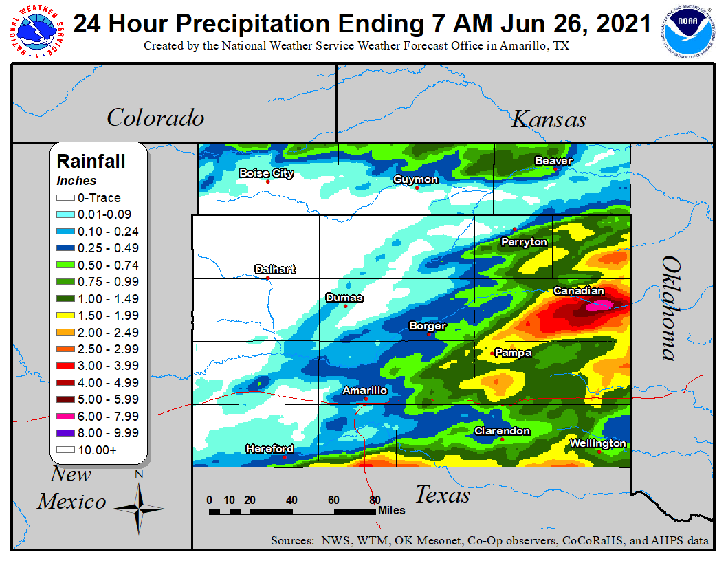 |
| Rainfall over the 24 hours ending at 7AM on June 26th. Estimated using a combination of ASOS, West Texas Mesonet, Oklahoma Mesonet, COOP, and CoCoRaHs ground observations and radar rain estimates |
Environment
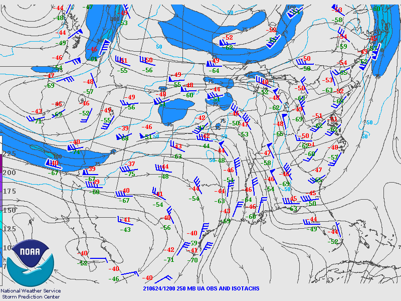
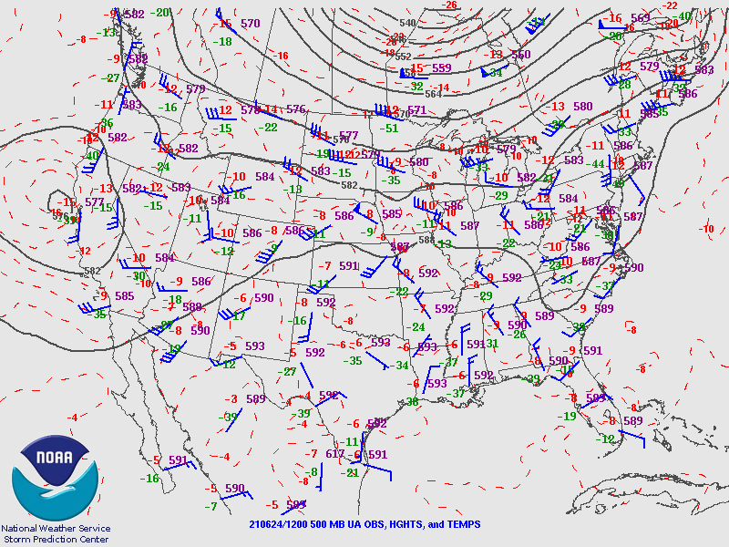
As evidenced by relatively weak flow in the upper (left) and middle (center) parts of the atmosphere, the June 24th event was kicked off by only a weak disturbance aloft. However, lower level moisture (right) was plentiful, so storms did develop. Moving ahead to June 25th, a large scale upper system approached. With the moisture still around, thunderstorms developed in abundance for many hours.
 |
 |
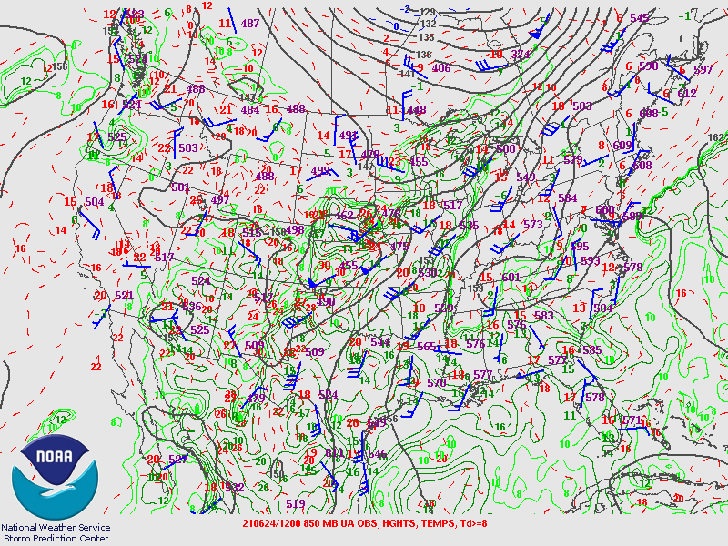 |
| Upper atmosphere (250mb) wind plots from June 24th and 25th. | Middle atmosphere (500mb) analysis from June 24th and 25th. | Lower level (850mb) analysis from June 24th and 25th. |
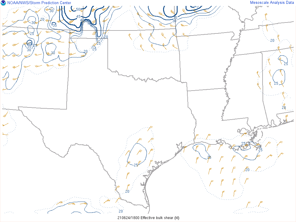
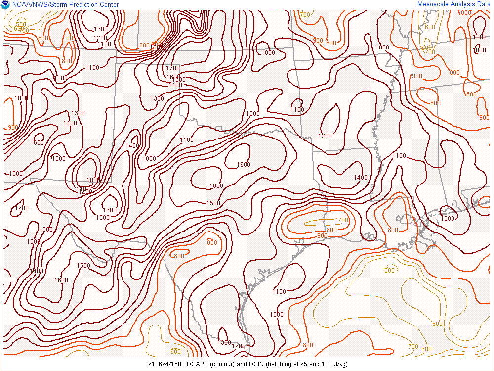
While wind shear (left) was enough for severe storms on the 24th, it increased ahead of that large scale upper system for the 25th, with more widespread severe storms occurring as a result. Potential downdraft strength (center) was very high both days. The overall moisture in the atmosphere (right) increased for the 25th, leading to noticeably higher rainfall.
 |
 |
 |
| Wind shear from June 24th and 25th. | Measure of potential downdraft strength (DCAPE) from June 24th and 25th. Values above 1500 J/kg are high for the Panhandles. | Measure of potential for heavy rainfall (precipitable water) from June 24th and 25th. Values above 1.5" are high for the Panhandles. |
 |
Media use of NWS Web News Stories is encouraged! Please acknowledge the NWS as the source of any news information accessed from this site. |
|

