National Weather Service United States Department of Commerce
June 30, 2014 Severe Storms
 

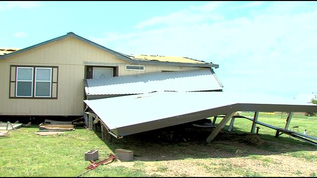
Severe thunderstorms produced wind gusts up to 85 mph, blowing dust, widespread wind damage, and knocked out power to many residents across the Oklahoma Panhandle and the Texas Panhandle during the late evening hours on Monday, June 30.  In fact, over 200 power poles were downed across the Oklahoma Panhandle by these storms, which left thousands of people without power.  As these storms moved out of Southeast Colorado and into Cimarron County, they produced the first damage at Keyes where trees were blown down and a mobile home lost its roof. The storms also caused a wall of blowing dust north of Boise City that look eerily similar to the Dust Bowl days!


Thunderstorms kicked up a wall of dirt north of Boise City (Angelique Andrea Clifford)

The storms continued barreling eastward, next targeting Guymon.  A 77 mph wind gust was officially recorded at Guymon at 9:17 PM.  Other reports of downed trees occurred in Guymon, but the most significant damage was a roof blown off a house.  The storms temporarily weakened as they moved over eastern Texas County, but they quickly restrengthened upon entering Beaver County.  In fact, several trees were knocked down across Beaver County, and an 85 mph wind gust was measured at Beaver at 10:35 PM. 

Damage in Keyes, OK Damage in Keyes, OK Damage in Guymon, OK
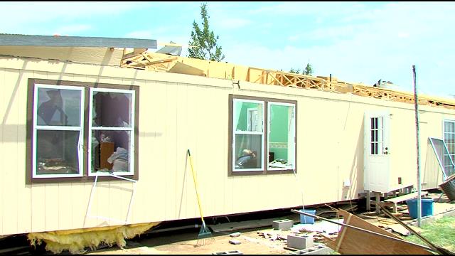
A mobile home in Keyes, OK lost its roof. (KFDA) A carport awning collapses in Keyes, OK (KFDA) 
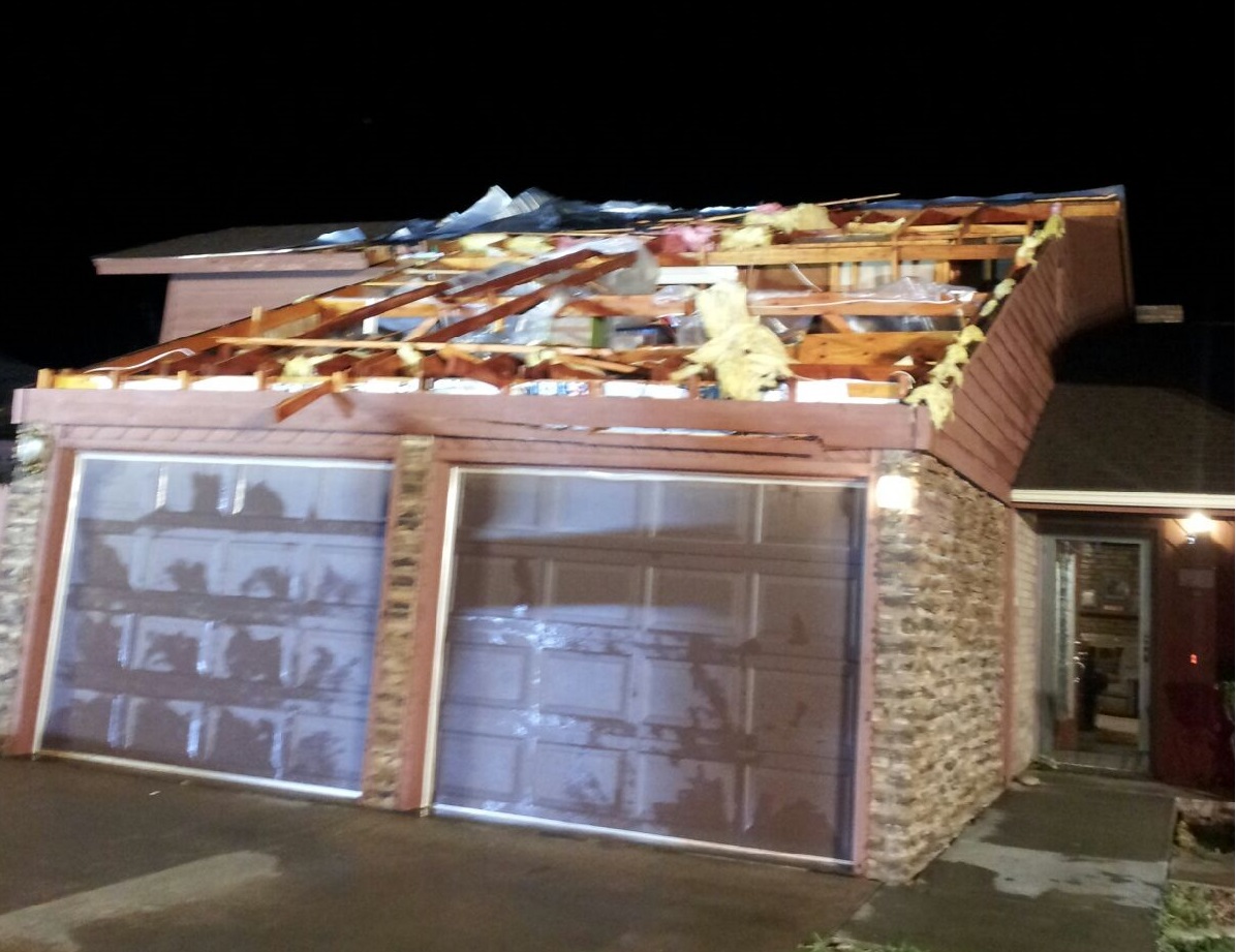
A roof blown off a home in Guymon OK (Harold Tyson)

The storms developed farther south into the Texas Panhandle where additional severe wind gusts occurred near Morse in Hansford County.  The storms produced strong outflow winds well ahead of the storms that caused wind gusts up 66 mph across Moore, Hutchinson, and Gray Counties.  The storms finally began weakening across the eastern Texas Panhandle, but not before producing more damage at Canadian. 


Estimated rainfall totals Storm approaching Hooker, OK
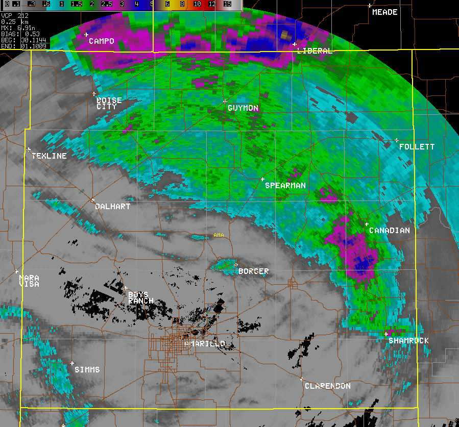
Radar estimated storm total precipitation Storm approaching Hooker, OK (Stanley Harper)

As the storms weakened, the threat shifted to heavy rain that caused some localized flooding across the eastern Texas Panhandle.  In fact, radar estimated as much as 4 inches of rain fell across southern Hemphill County.

 
STORM REPORTS
PRELIMINARY LOCAL STORM REPORT...SUMMARY
NATIONAL WEATHER SERVICE AMARILLO TX
1020 AM CDT TUE JUL 01 2014

..TIME...   ...EVENT...      ...CITY LOCATION...     ...LAT.LON...
..DATE...   ....MAG....      ..COUNTY LOCATION..ST.. ...SOURCE....
            ..REMARKS..

0800 PM     TSTM WND GST     KEYES                   36.81N 102.25W
06/30/2014  E70 MPH          CIMARRON           OK   PUBLIC

0810 PM     TSTM WND GST     3 SSE BOISE CITY        36.69N 102.50W
06/30/2014  M73 MPH          CIMARRON           OK   MESONET

0815 PM     TSTM WND GST     3 SSE BOISE CITY        36.69N 102.50W
06/30/2014  M60 MPH          CIMARRON           OK   MESONET

0815 PM     TSTM WND DMG     10 SE KEYES             36.71N 102.12W
06/30/2014                   CIMARRON           OK   PUBLIC

            BLEW TREES DOWN AND SEVERAL BRANCHES BROKEN OFF

0820 PM     TSTM WND GST     3 SSE BOISE CITY        36.69N 102.50W
06/30/2014  M60 MPH          CIMARRON           OK   MESONET

0825 PM     TSTM WND GST     3 SSE BOISE CITY        36.69N 102.50W
06/30/2014  M62 MPH          CIMARRON           OK   MESONET

0900 PM     TSTM WND GST     5 N GUYMON              36.76N 101.48W
06/30/2014  E65 MPH          TEXAS              OK   TRAINED SPOTTER

            ESTIMATED 60 TO 70 MPH WINDS.

0903 PM     TSTM WND GST     8 N EVA                 36.92N 101.90W
06/30/2014  M61 MPH          TEXAS              OK   BROADCAST MEDIA

0915 PM     TSTM WND GST     2 E GOODWELL            36.60N 101.60W
06/30/2014  M65 MPH          TEXAS              OK   MESONET

0916 PM     TSTM WND GST     5 N GUYMON              36.76N 101.48W
06/30/2014  E60 MPH          TEXAS              OK   EMERGENCY MNGR

            TREE BLEW DOWN IN FRONT OF HIM WHILE DRIVING. POWER OUT
            IN GOODWELL. GOODWELL ON GENERATOR POWER.

0917 PM     TSTM WND GST     2 W GUYMON              36.69N 101.51W
06/30/2014  M77 MPH          TEXAS              OK   ASOS

0920 PM     TSTM WND GST     2 E GOODWELL            36.60N 101.60W
06/30/2014  M64 MPH          TEXAS              OK   MESONET

0923 PM     HAIL             7 N OPTIMA              36.86N 101.36W
06/30/2014  M1.25 INCH       TEXAS              OK   EMERGENCY MNGR

0934 PM     TSTM WND GST     3 NNE HOOKER            36.90N 101.20W
06/30/2014  M62 MPH          TEXAS              OK   BROADCAST MEDIA

0940 PM     TSTM WND GST     2 E GOODWELL            36.60N 101.60W
06/30/2014  M67 MPH          TEXAS              OK   MESONET

0940 PM     TSTM WND GST     20 N DALHART            36.35N 102.52W
06/30/2014  E75 MPH          DALLAM             TX   PUBLIC

0940 PM     TSTM WND DMG     GUYMON                  36.69N 101.48W
06/30/2014                   TEXAS              OK   NEWSPAPER

            TRI-COUNTY ELECTRIC COOPERATIVE REPORTS MORE THAN 100
            POWER POLES BROKEN OVER THE SERVICE TERRITORY FROM
            CIMARRON COUNTY TO TEXAS COUNTY. THOUSANDS OF MEMBERS
            WITHOUT POWER. TIME ESTIMATED.

0942 PM     TSTM WND DMG     1 NNW GUYMON            36.70N 101.49W
06/30/2014                   TEXAS              OK   EMERGENCY MNGR

            ROOF BLOWN OFF HOUSE AND ACROSS THE STREET.

1000 PM     TSTM WND GST     2 W GUYMON              36.69N 101.51W
06/30/2014  M59 MPH          TEXAS              OK   ASOS

1015 PM     TSTM WND GST     2 E GOODWELL            36.60N 101.60W
06/30/2014  M58 MPH          TEXAS              OK   MESONET

1020 PM     TSTM WND GST     2 E GOODWELL            36.60N 101.60W
06/30/2014  M59 MPH          TEXAS              OK   MESONET

            VIA OKLAHOMA MESONET

1025 PM     TSTM WND GST     2 E GOODWELL            36.60N 101.60W
06/30/2014  M66 MPH          TEXAS              OK   MESONET

1030 PM     TSTM WND GST     2 E GOODWELL            36.60N 101.60W
06/30/2014  M60 MPH          TEXAS              OK   MESONET

1030 PM     TSTM WND GST     1 SSW BEAVER            36.80N 100.53W
06/30/2014  M66 MPH          BEAVER             OK   MESONET

1035 PM     TSTM WND GST     1 SSW BEAVER            36.80N 100.53W
06/30/2014  M85 MPH          BEAVER             OK   MESONET

1035 PM     TSTM WND GST     3 W DUMAS               35.86N 102.01W
06/30/2014  M66 MPH          MOORE              TX   AWOS

1040 PM     TSTM WND DMG     BEAVER                  36.81N 100.52W
06/30/2014                   BEAVER             OK   EMERGENCY MNGR

            SEVERAL TREES DOWN ACROSS THE COUNTY WITH ESTIMATED 80
            MPH WINDS.

1040 PM     TSTM WND GST     1 SSW BEAVER            36.80N 100.53W
06/30/2014  M77 MPH          BEAVER             OK   MESONET

1045 PM     TSTM WND GST     1 SSW BEAVER            36.80N 100.53W
06/30/2014  M73 MPH          BEAVER             OK   MESONET

1050 PM     TSTM WND GST     8 W SLAPOUT             36.60N 100.26W
06/30/2014  M58 MPH          BEAVER             OK   MESONET

            VIA OKLAHOMA MESONET

1050 PM     HAIL             11 SW KNOWLES           36.76N 100.33W
06/30/2014  E1.75 INCH       BEAVER             OK   EMERGENCY MNGR

1050 PM     TSTM WND GST     1 SSW BEAVER            36.80N 100.53W
06/30/2014  M72 MPH          BEAVER             OK   MESONET

1053 PM     HAIL             6 S GRUVER              36.17N 101.41W
06/30/2014  E1.00 INCH       HANSFORD           TX   LAW ENFORCEMENT

1055 PM     TSTM WND GST     8 W SLAPOUT             36.60N 100.26W
06/30/2014  M74 MPH          BEAVER             OK   MESONET

            VIA OKLAHOMA MESONET

1055 PM     TSTM WND GST     MORSE                   36.06N 101.47W
06/30/2014  E60 MPH          HANSFORD           TX   TRAINED SPOTTER

1100 PM     TSTM WND GST     8 W SLAPOUT             36.60N 100.26W
06/30/2014  M65 MPH          BEAVER             OK   MESONET

            VIA OKLAHOMA MESONET

1102 PM     TSTM WND GST     1 WNW STINNETT          35.83N 101.45W
06/30/2014  M66 MPH          HUTCHINSON         TX   BROADCAST MEDIA

            SCHOOLNET SITE.

1121 PM     HIGH SUST WINDS  2 N BORGER              35.70N 101.40W
06/30/2014  M41 MPH          HUTCHINSON         TX   ASOS

1125 PM     TSTM WND GST     FRITCH                  35.64N 101.60W
06/30/2014  E60 MPH          HUTCHINSON         TX   PUBLIC

            REPORT OF HOUSE BEING SHOOK BY HIGH THUNDERSTORM WINDS
            IN FRITCH.

1126 PM     TSTM WND GST     LIPSCOMB                36.23N 100.27W
06/30/2014  E60 MPH          LIPSCOMB           TX   LAW ENFORCEMENT

1135 PM     NON-TSTM WND GST 5 NNW PAMPA             35.61N 101.00W
06/30/2014  M63 MPH          GRAY               TX   AWOS

1146 PM     TSTM WND GST     8 NW MIAMI              35.77N 100.74W
06/30/2014  M59 MPH          ROBERTS            TX   BROADCAST MEDIA

            VIA KVII SCHOOLNET

1147 PM     TSTM WND GST     8 N MIAMI               35.81N 100.64W
06/30/2014  M63 MPH          ROBERTS            TX   BROADCAST MEDIA

            VIA KVII SCHOOLNET

1155 PM     NON-TSTM WND GST 2 ESE PAMPA             35.54N 100.93W
06/30/2014  M66 MPH          GRAY               TX   MESONET

1200 AM     TSTM WND DMG     CANADIAN                35.91N 100.38W
07/01/2014                   HEMPHILL           TX   LAW ENFORCEMENT

            POWERLINES DOWN AT 3RD STREET AND ELSIE AVENUE. ONE
            POWERLINE CAUSED A FIRE.

1210 AM     TSTM WND DMG     9 SE CANADIAN           35.82N 100.27W
07/01/2014                   HEMPHILL           TX   LAW ENFORCEMENT

            FALLEN TREE BLOCKING HIGHWAY 33 BETWEEN COUNTY ROADS 17
            AND 18.

1211 AM     TSTM WND GST     6 E CANADIAN            35.92N 100.28W
07/01/2014  M64 MPH          HEMPHILL           TX   MESONET


&&