
Much higher than typical October temperatures will continue across coastal southern California up through the Bay Area and Central Valley through midweek resulting in result in Major to Extreme HeatRisk. A tropical depression is likely to form over the Gulf of America during the middle part of this week with further strengthening possible as it moves northeastward later this week. Read More >
Overview
A vigorous upper level low moved east from southern Colorado across south central Kansas through the late afternoon on Tuesday, June 9, 2020. As it did, a surface low deepened and moved east across Kansas pushing a cold front south across the Panhandles and western Texas. The cold front moved into the Oklahoma Panhandle early in the morning and quickly swept south across the region. A strong pressure gradient between the low over Kansas and high pressure surging southeast out of Colorado created very strong winds across the region behind the front which lasted into the evening.
Across the northern Panhandles, sustained winds increased to 35 to 45 mph out of the north to northwest with gusts mainly in the 55 to 65 mph range. Further south, sustained winds generally ranged from 25 to 35 with gusts reaching 45 to 55 mph. These strong winds lasted most of the day before finally diminishing from west to east beginning in the late afternoon. Although the relative humidity was only 15 to 35 percent across the central and western Panhandles, the high winds and dry fuels associated with recent onset of moderate to extreme drought in the area led to a high wildfire danger across part of the region.
Wildfires
Numerous wildfires were reported across the region and five of them were large enough to be viewed from GOES Satellite. The largest fire occurred west of Skellytown in Carson County. This fire, called the Yandy Fire, reached nearly 3000 acres by Wednesday. The second largest fire burned a little over 100 acres in Sherman County. Other fires remained much less than 100 acres.
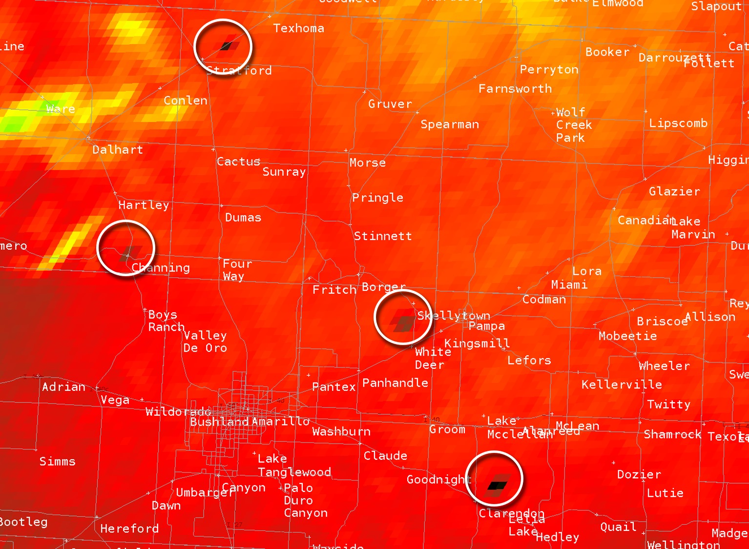 |
| Multiple wildfires visible on the GOES 3.9 micrometer fire detection channel (NOAA/NASA GOES-16) |
Photos & Video
| Blowing dust due to high winds across the Panhandles on June 9th, 2020 (NOAA/NASA GOES-16) |
High Winds and Blowing Dust
Strong winds and dry conditions led to quite a bit of dust being lifted into the atmosphere. Visibilities were generally 3 to 6 miles due to the dust, but near 0 visibility occurred in very isolated locations adjacent to plowed fields, construction sites, etc. Multiple accidents occurred due to these hazardous driving conditions. The worst of these accidents occured on US 54 around 11 miles northeast of Stratford. This accident, caused by poor visibility due to blowing dust, involved three 18 wheelers. There were unfortunately two fatalities reported with this accident. The highest wind gusts recorded across the Panhandles are listed below:
| Location | Type | Highest Gust (mph) | Time |
|---|---|---|---|
| Hooker 1 W | OK Mesonet | 68 | 1:35 PM |
| Perryton | AWOS | 67 | 6:15 PM |
| Beaver 1 SSW | OK Mesonet | 67 | 7:00 PM |
| Boise City 3 SSE | OK Mesonet | 67 | 2:15 PM |
| Stinnett 1 NNW | WT Mesonet | 66 | 4:27 PM |
| Goodwell 2 E | OK Mesonet | 66 | 4:15 PM |
| Slapout 8 W | OK Mesonet | 66 | 7:30 PM |
| Palo Duro Reservoir 1 NW | WT Mesonet | 64 | 4:17 PM |
| Guymon | ASOS | 63 | 2:25 PM |
| Stratford 4 WNW | WT Mesonet | 63 | 2:32 PM |
| Eva 12 NE | OK Mesonet | 63 | 3:20 PM |
| Dalhart | ASOS | 62 | 2:36 PM |
| Canadian 6 E | WT Mesonet | 62 | 5:55 PM |
| Dumas | AWOS | 61 | 2:55 PM |
| Pampa | AWOS | 61 | 5:35 PM |
| Lake McClellan 2 NW | WT Mesonet | 59 | 4:21 PM |
| Amarillo | ASOS | 58 | 2:55 PM |
| Borger | ASOS | 58 | 4:04 PM |
| Fritch 1 WNW | WT Mesonet | 58 | 3:55 PM |
| McLean 1 E | WT Mesonet | 57 | 5:50 PM |
| Palo Duro Canyon Floor | WT Mesonet | 57 | 3:34 PM |
| Amarillo 15 NNW | WT Mesonet | 56 | 2:37 PM |
| Pampa 2 E | WT Mesonet | 56 | 1:50 PM |
| Canadian | AWOS | 55 | 5:55 PM |
| Amarillo 7 SSE | WT Mesonet | 55 | 3:20 PM |
| Claude 12 SSW | WT Mesonet | 55 | 2:58 PM |
| Umbarger 3 NNE | WT Mesonet | 55 | 1:53 PM |
| Wheeler | RAWS | 55 | 4:52 PM |
| Amarillo 9 NNE | WT Mesonet | 54 | 4:39 PM |
| Palo Duro 4 E / JA Ranch | WT Mesonet | 54 | 3:25 PM |
| Romero 11 SSW | WT Mesonet | 54 | 12:53 PM |
| Cedar | RAWS | 54 | 4:35 PM |
| Mesa Vista Ranch | AWOS | 53 | 3:55 PM |
| Clarendon 2 W | WT Mesonet | 53 | 4:55 PM |
| Goodnight | WT Mesonet | 53 | 4:32 PM |
| Palo Duro Canyon Rim | WT Mesonet | 52 | 3:30 PM |
| Adrian 6 WSW | WT Mesonet | 49 | 1:40 PM |
| Dozier 3 W | WT Mesonet | 49 | 4:26 PM |
| Hereford | AWOS | 48 | 12:55 PM |
| Hereford 2 NW | WT Mesonet | 48 | 2:00 PM |
| Bootleg 11 WNW | WT Mesonet | 47 | 3:37 AM |
| Boys Ranch 1 WSW | WT Mesonet | 47 | 1:18 PM |
| Bootleg | RAWS | 43 | 2:03 PM |
 |
Media use of NWS Web News Stories is encouraged! Please acknowledge the NWS as the source of any news information accessed from this site. |
|



 Follow us on X
 Follow us on Facebook
 AMA RSS Feed