
Wildfires and poor air quality continue for the Pacific Northwest, Rockies and extended into the Plains. Severe thunderstorms possible for the northern Plains and upper Midwest on Monday along a frontal boundary. Another boundary will focus showers and thunderstorms for the eastern seaboard with localized heavy rainfall possible. For Alaska, a strong Bering Sea storm will bring winds and rainfall. Read More >
Overview
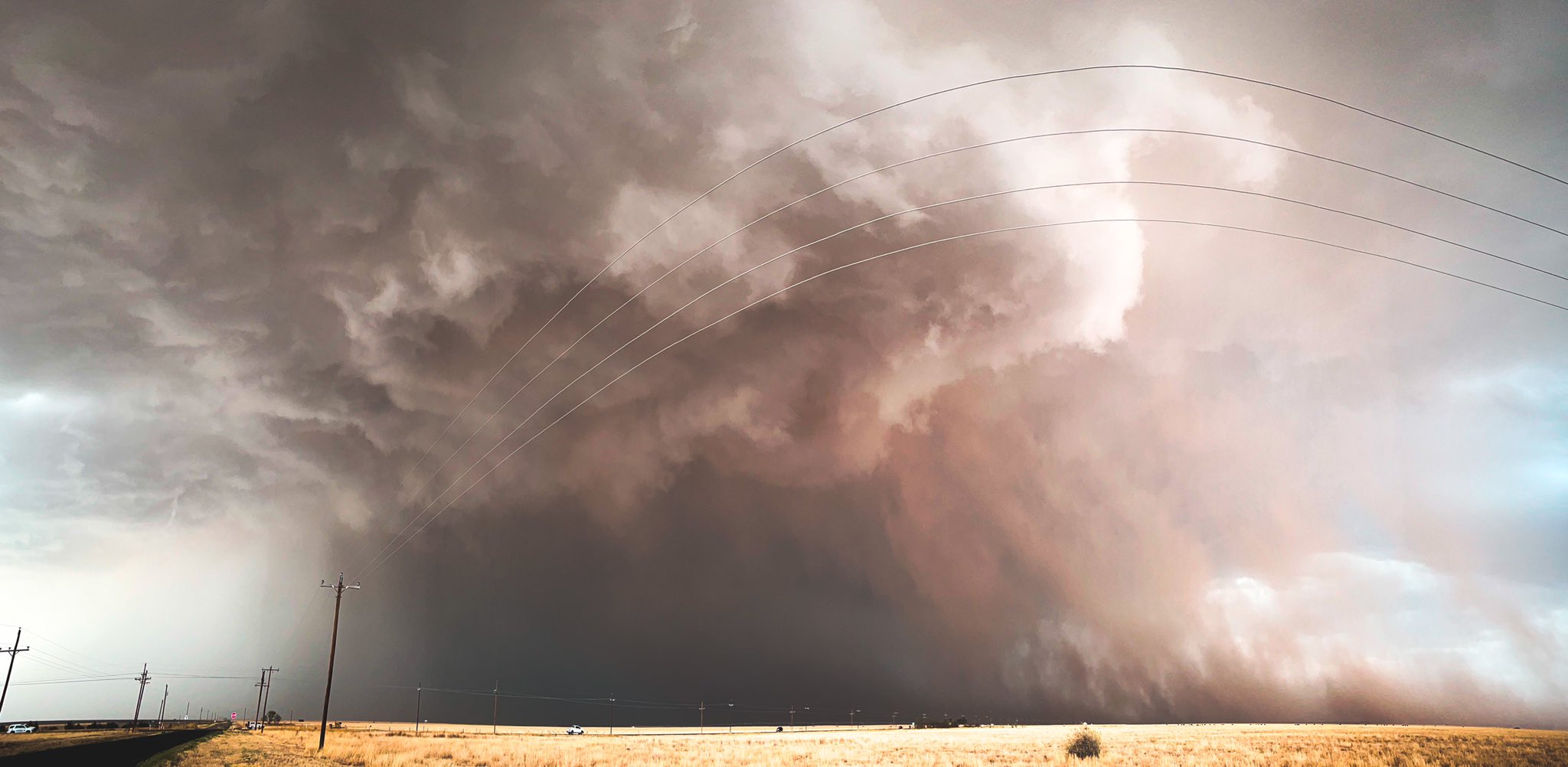
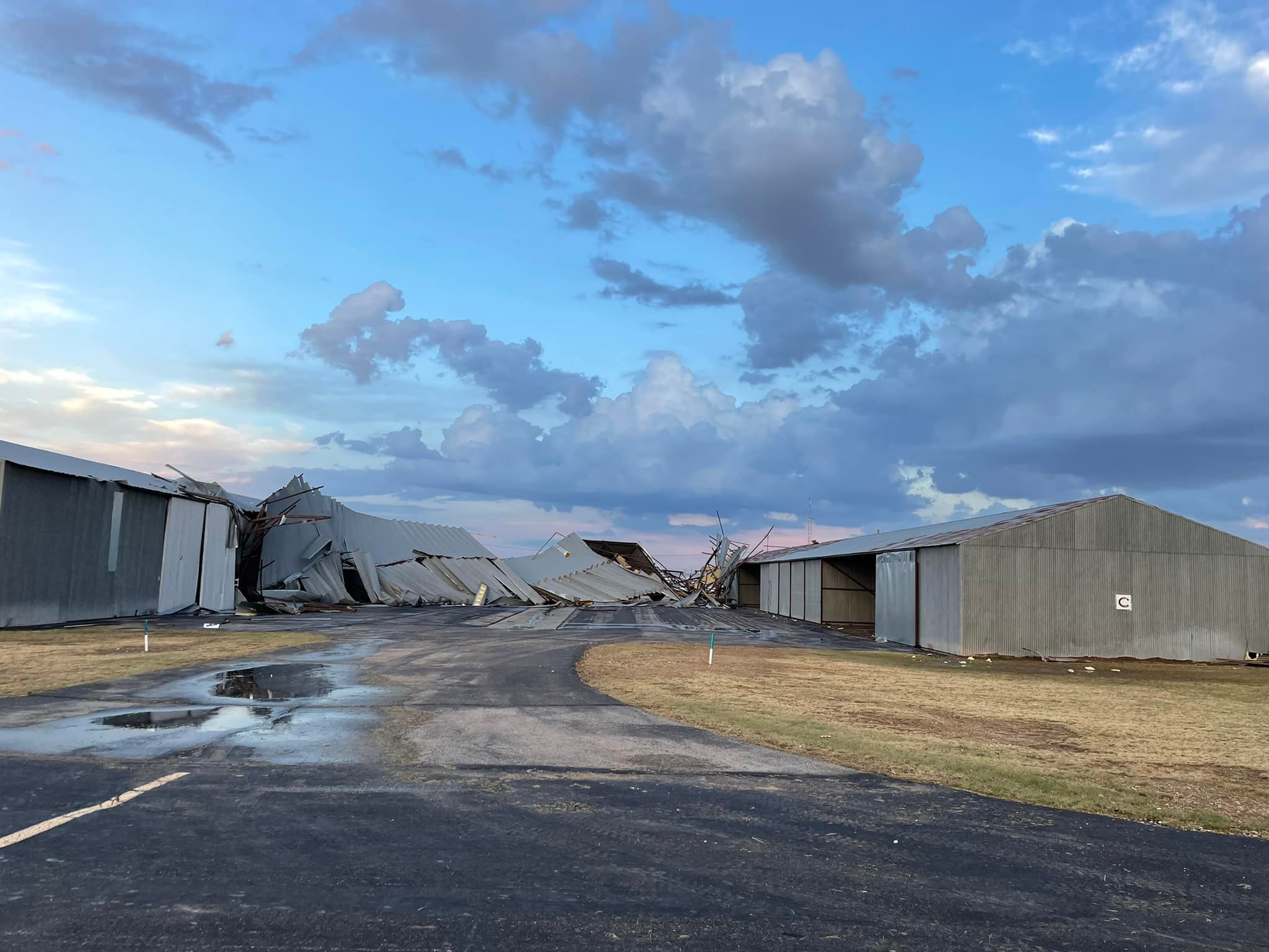
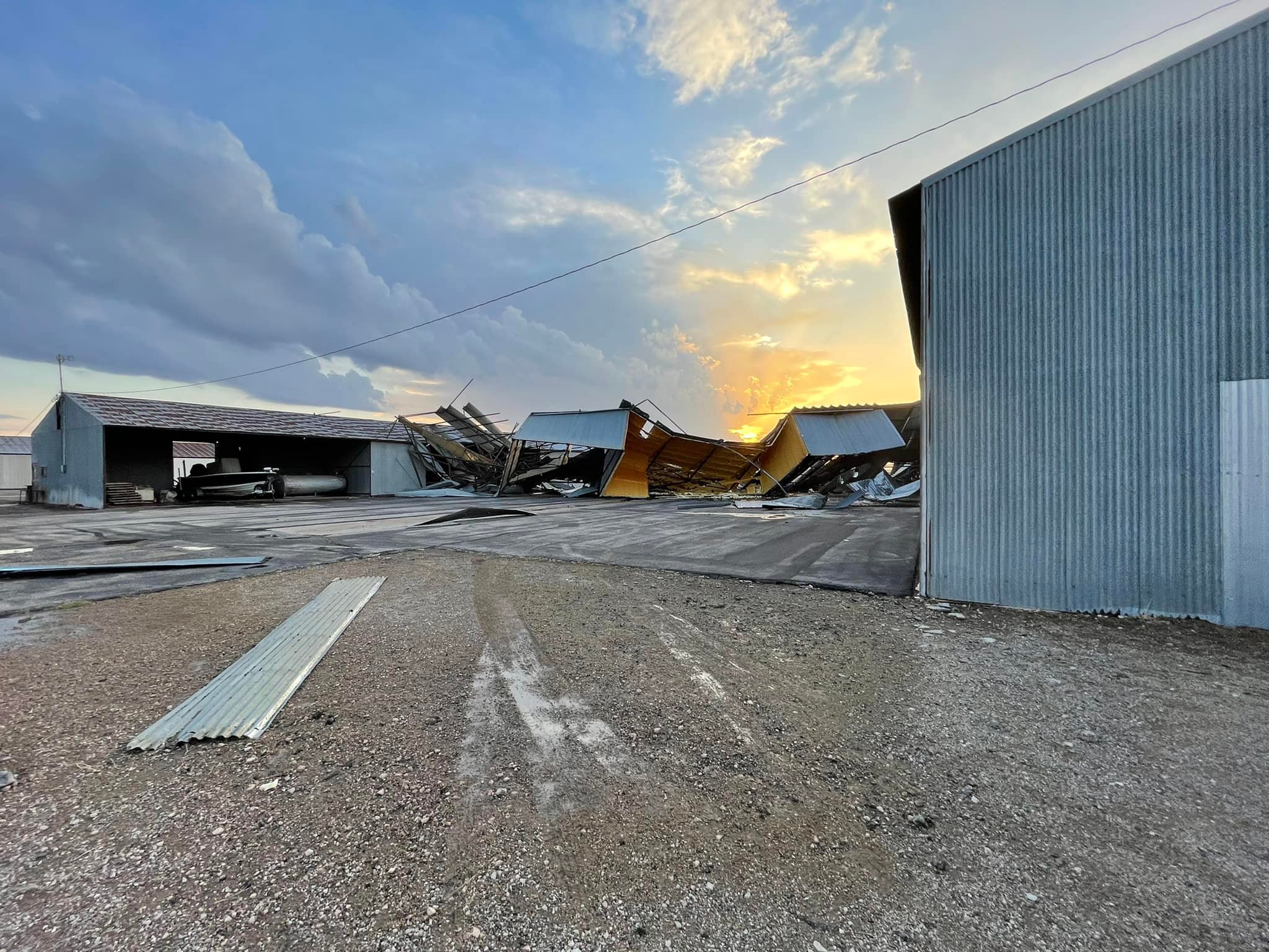
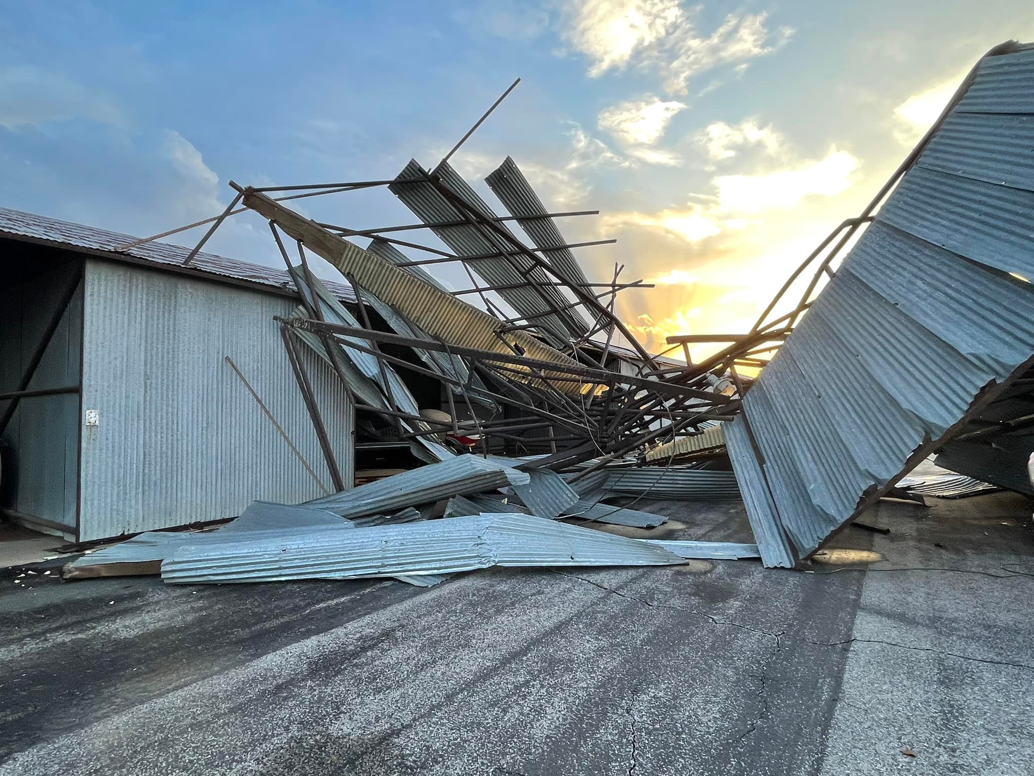
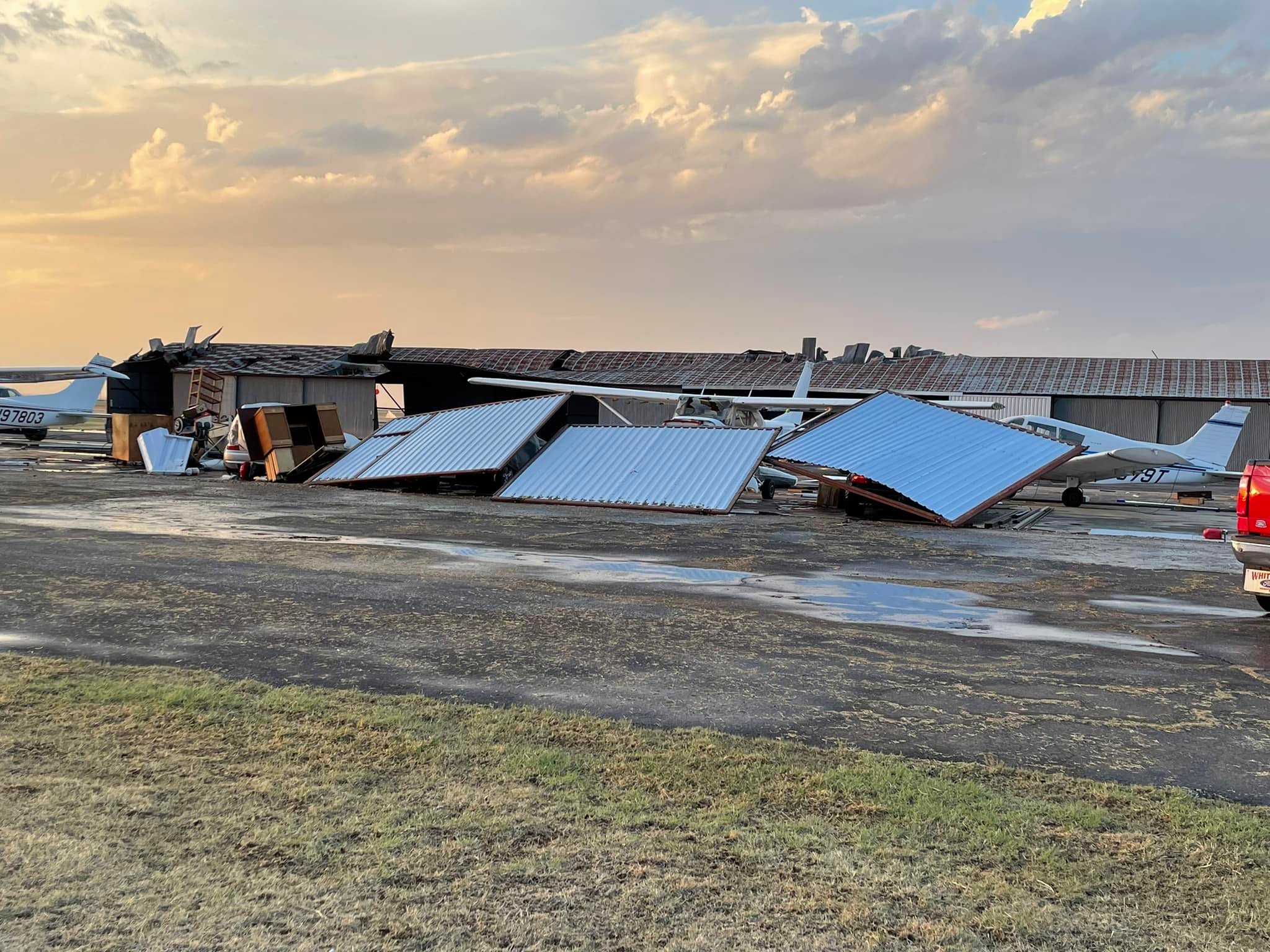
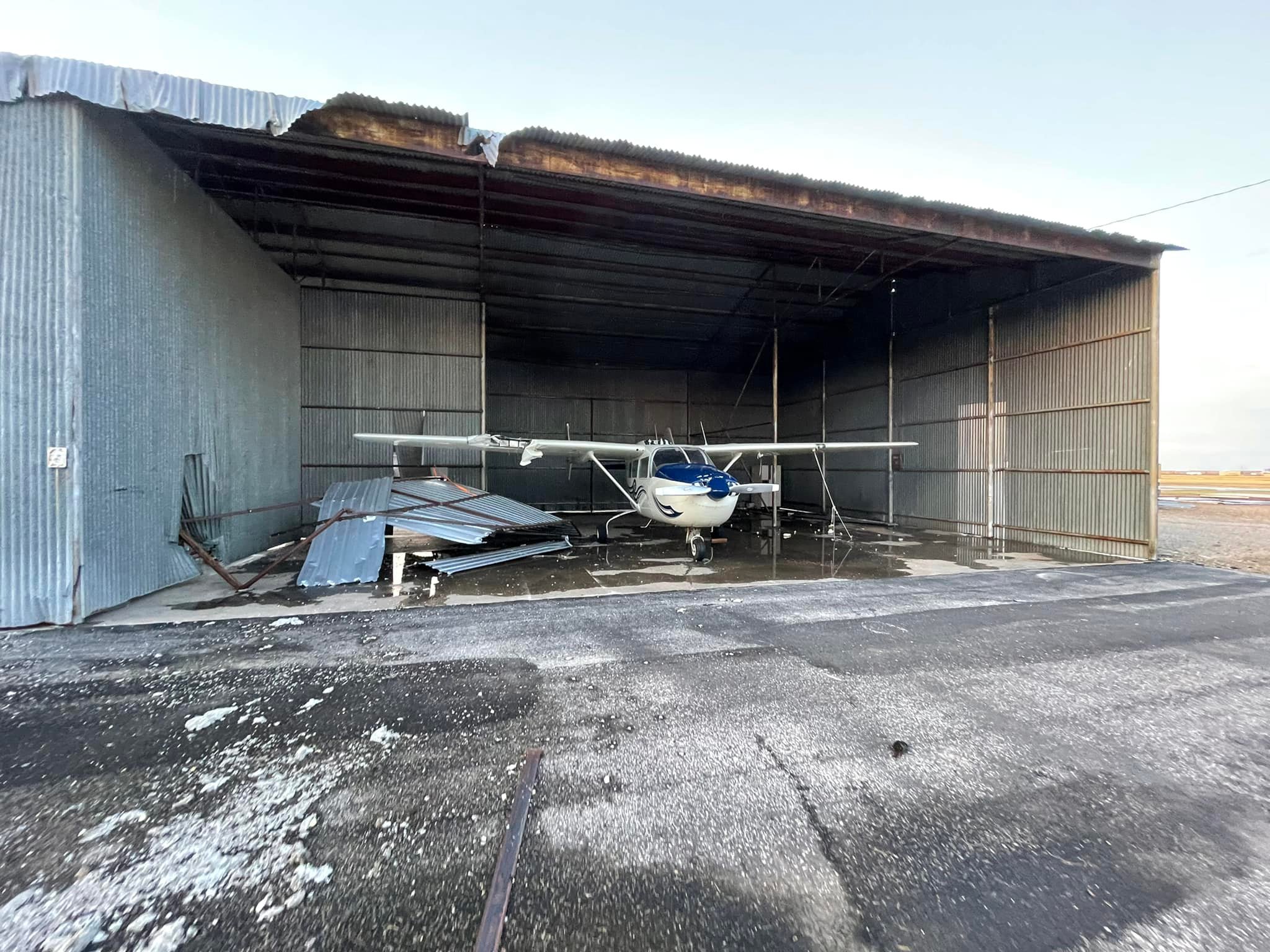
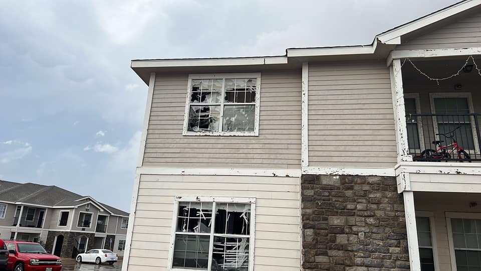
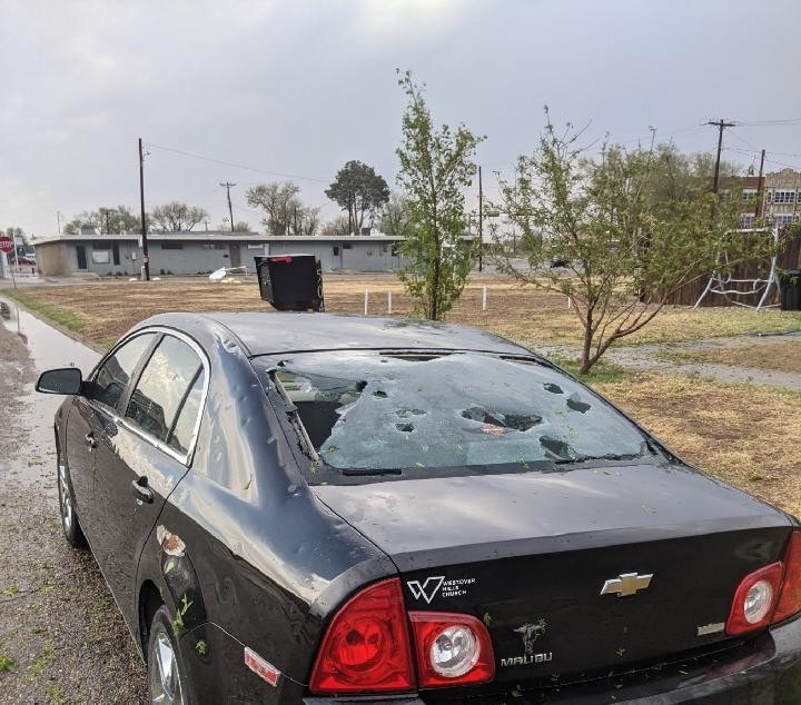
An upper level storm system traversed the Rocky Mountains and adjacent plains on Sunday and interacted with a dryline that was situated over eastern New Mexico. This led to the development of severe thunderstorms along and ahead of the boundary. High levels of wind shear allowed the activity to organize into supercell thunderstorms which produced large to very large hail and damaging wind as they tracked northeast across the Panhandles. The most intense storm produced baseball size hail and widespread damage in Hereford, Bushland and Bishop Hills. This storm destroyed a hangar at the Hereford Airport, broke out windows of homes and vehicles in the area and significantly damaged roofs. The highest wind gust of 86 mph was reported from the West Texas Mesonet 15 miles north-northwest of Amarillo. The inflow into another powerful supercell caused wind gusts in excess of 58 mph at the West Texas Mesonet 3 miles southeast of Dumas for an incredible 15 minutes and produced a peak gust of 72 mph. As the night progressed, storms decreased in coverage, but isolated supercells produced golf ball sized hail and ~60 mph winds as late as midnight. One other noteworthy report was a weak landspout in Fritch which produced minor damage. Landspouts are typically weak and short lived tornadoes that develop from the ground up rather then extending from a rotating cloud base down to the ground. For more information on how to prepare for severe weather season, please check out these resources from the NWS.
Photos & Video
 |
 |
 |
 |
| Golfball size hail in Bushland (Credit: Texas Venom Chasers) |
Hail damage in Bushland (Credit: Texas Venom Chasers) |
Car damage from hail in Bushland (Credit: Diana) |
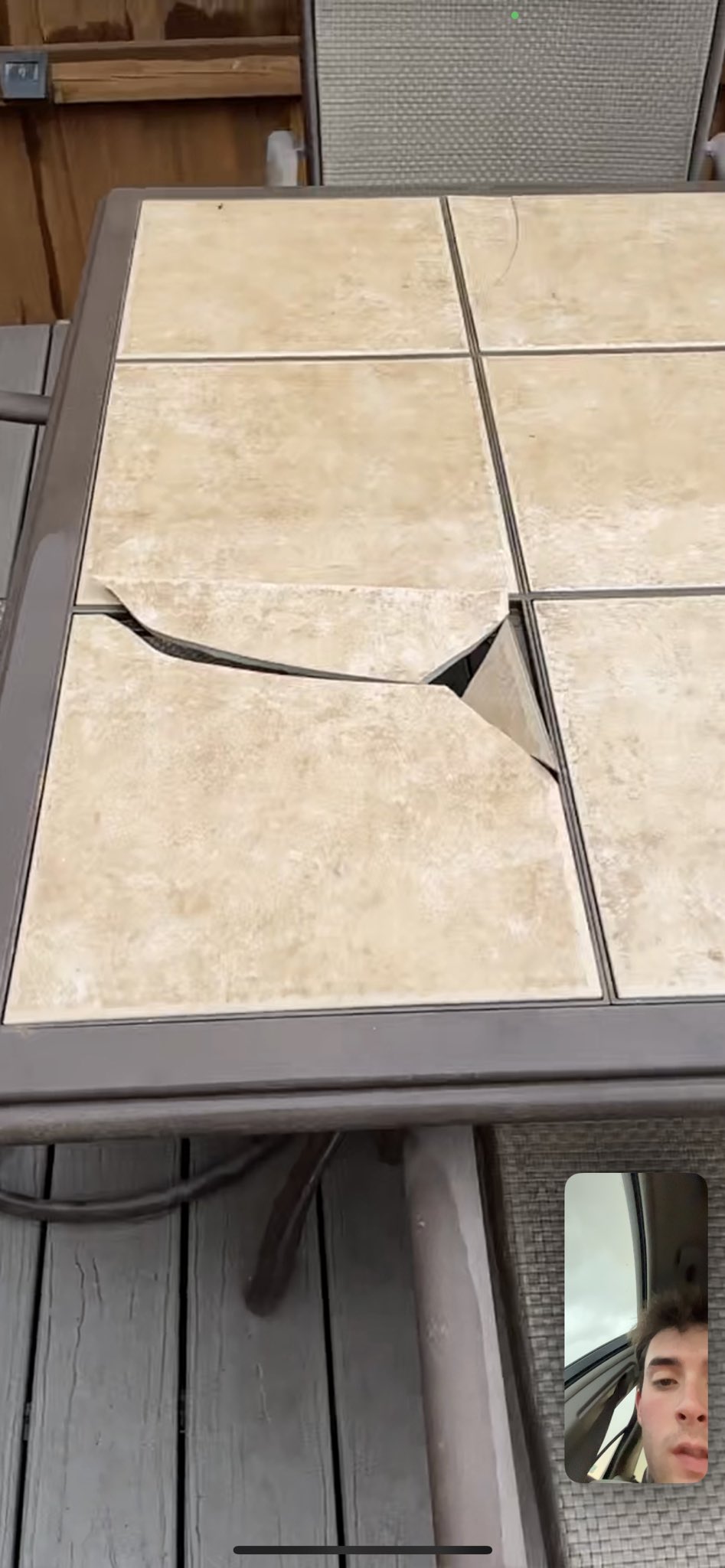
Patio furniture damage from hail in Bushland (Credit: Easton Whatley) |
 |
 |
 |
 |
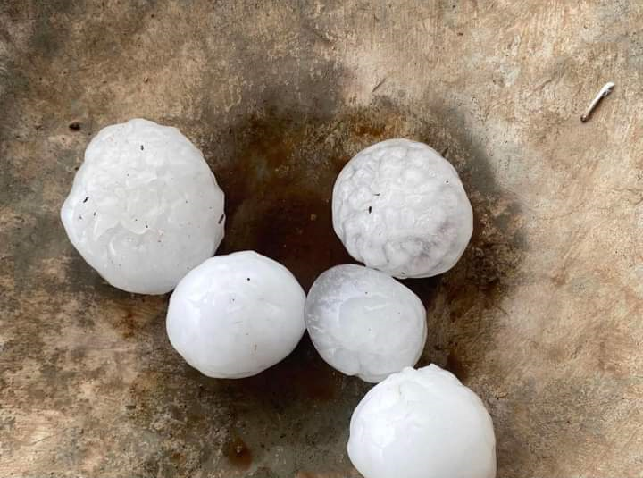
| Ping pong sized hail in Bushland (Credit: Diana) |
Tennis ball sized hail in Bushland (Credit: Easton Whatley) |
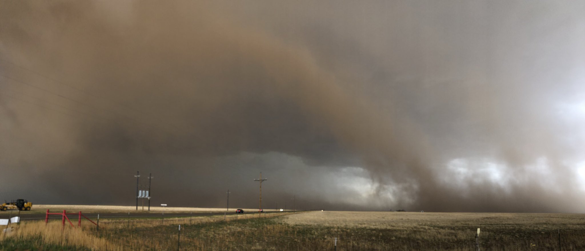
Strong blowing dust into storm near Dumas (Credit: Amarillo Cloud Chasing) |
Strong blowing dust into storm near Dumas (Credit: Dalhart Cloud Chasing) |
 |
 |
 |
 |
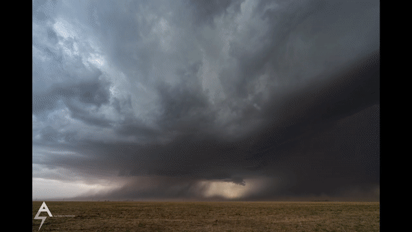
| Time Lapse of Blowing Dust Near Dumas (Credit: Alex Schueth) |
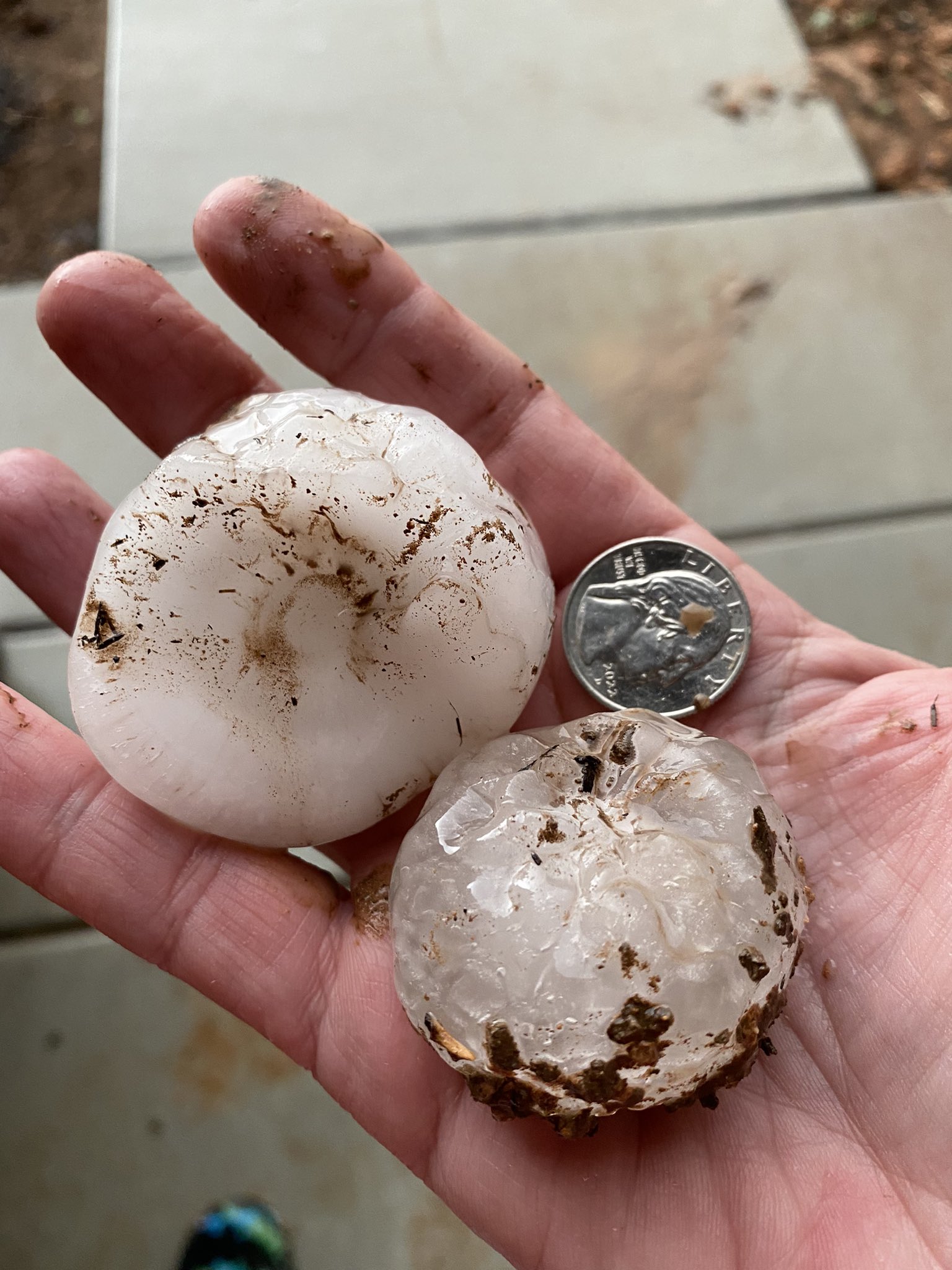
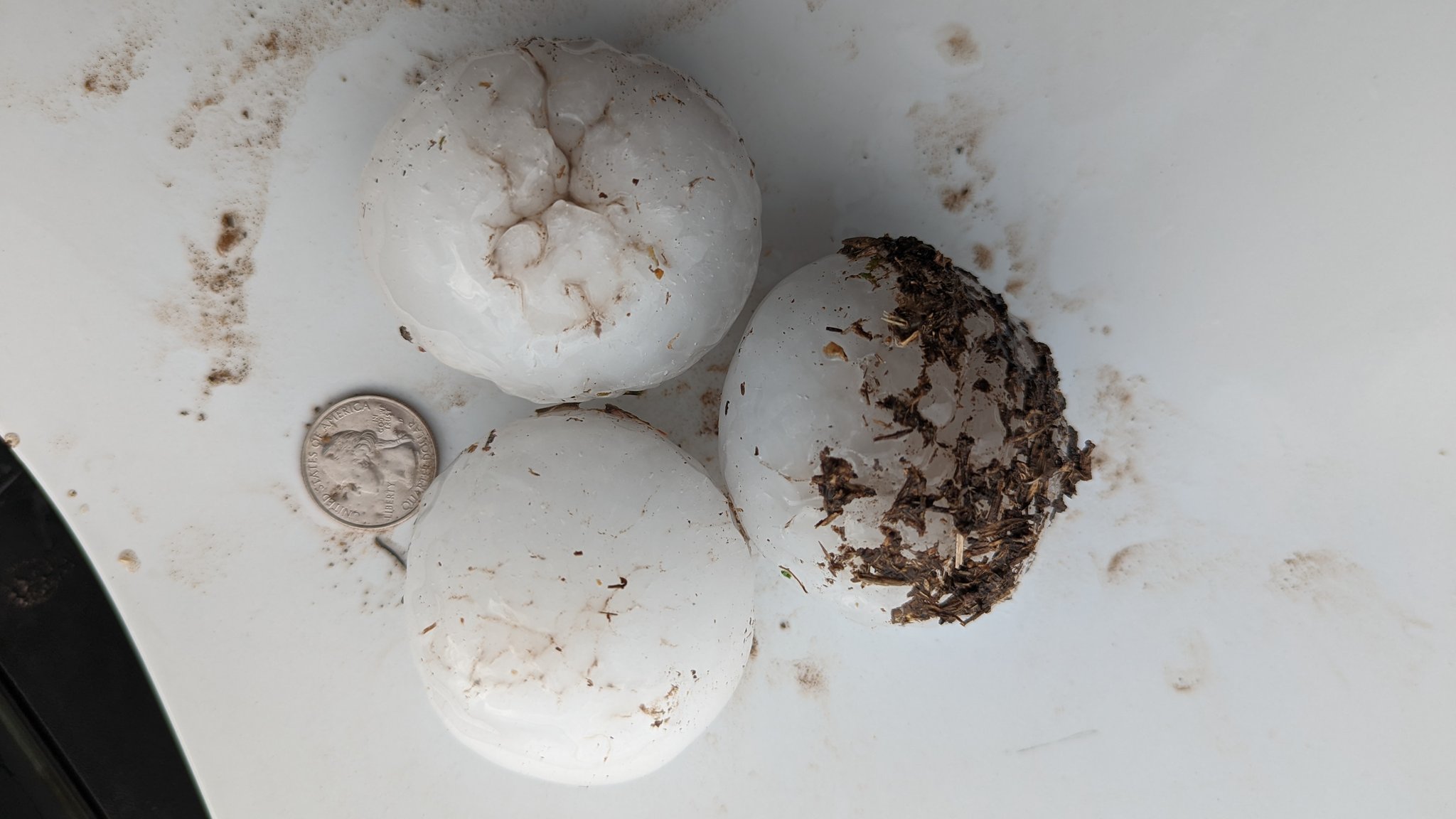
Golfball size hail in Dumas (Credit: Matt Minnillo) |
Tennis ball size hail north of Dawn (Credit: Wesley Luiginbyhl) |
Airport Damage in Herford (Credit: Hereford Brand) |
 |
 |
 |
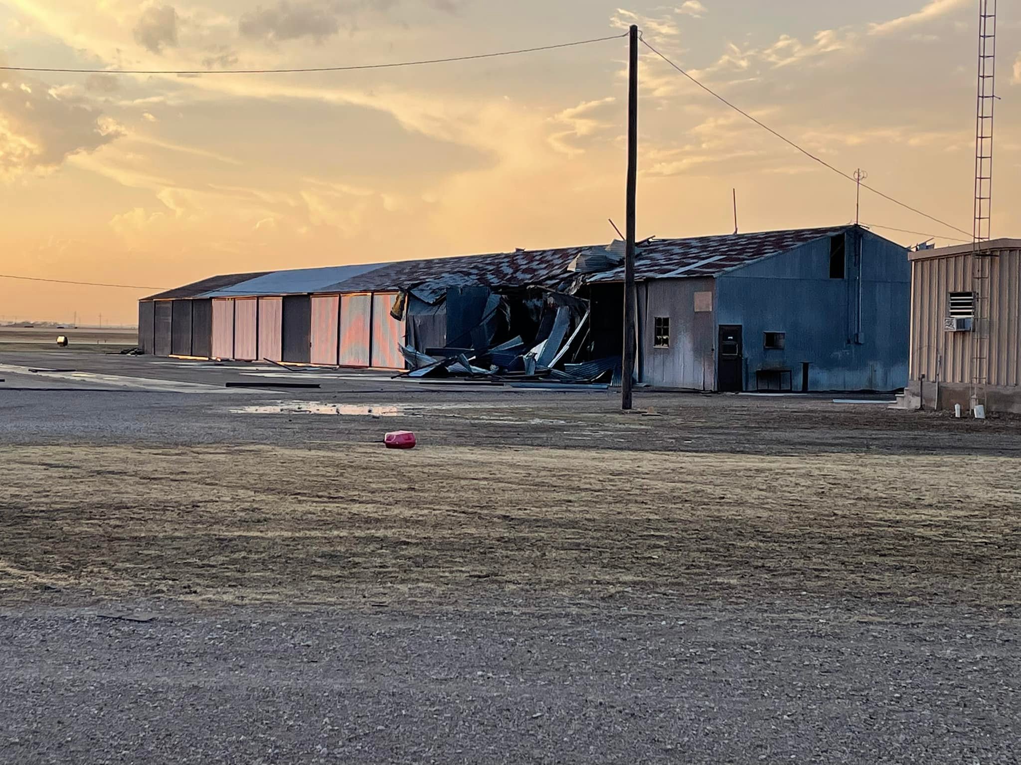 |
| Airport Damage in Herford (Credit: Hereford Brand) |
Airport Damage in Herford (Credit: Hereford Brand) |
Airport Damage in Herford (Credit: Hereford Brand) |
Airport Damage in Herford (Credit: Hereford Brand) |
 |
 |
 |
 |
| Airport Damage in Herford (Credit: Hereford Brand) |
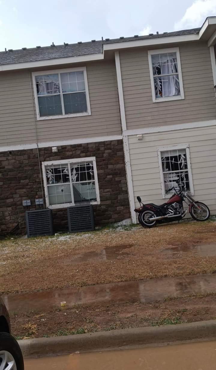
Hail damage in Hereford (Credit: Skyla Lea Garza) |
Car damage from hail in Hereford (Credit: Elena Martinez) |
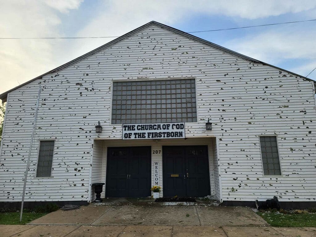
Church damage from hail in Hereford (Credit: Clarissa Medrano) |
 |
 |
 |
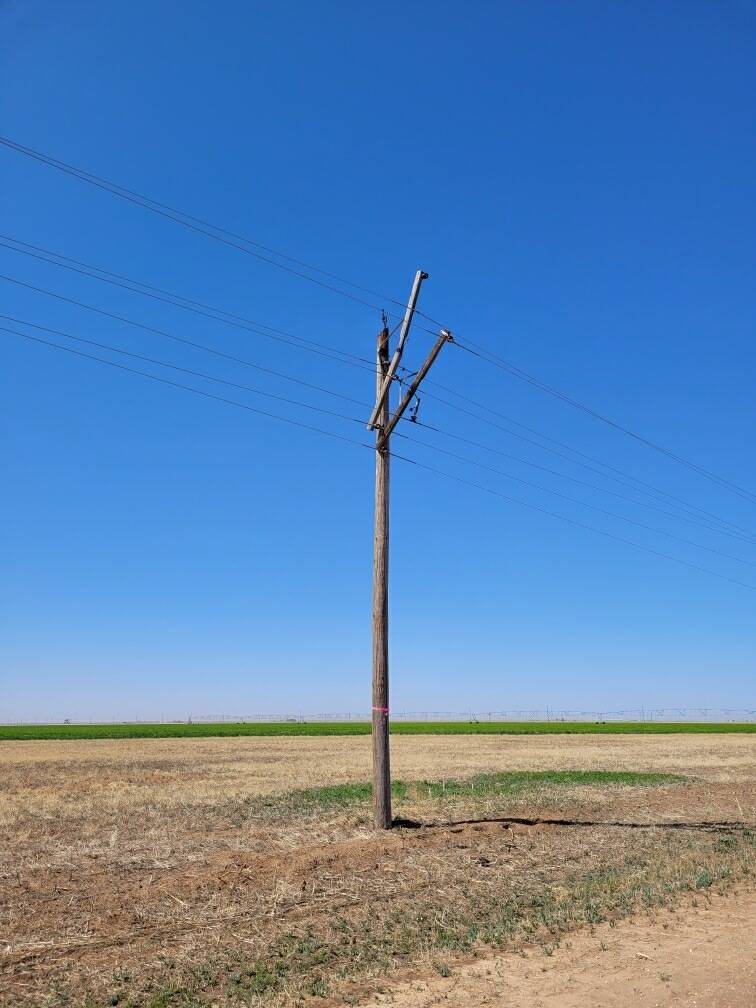 |
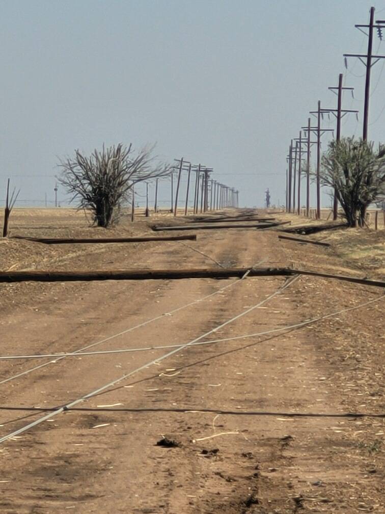
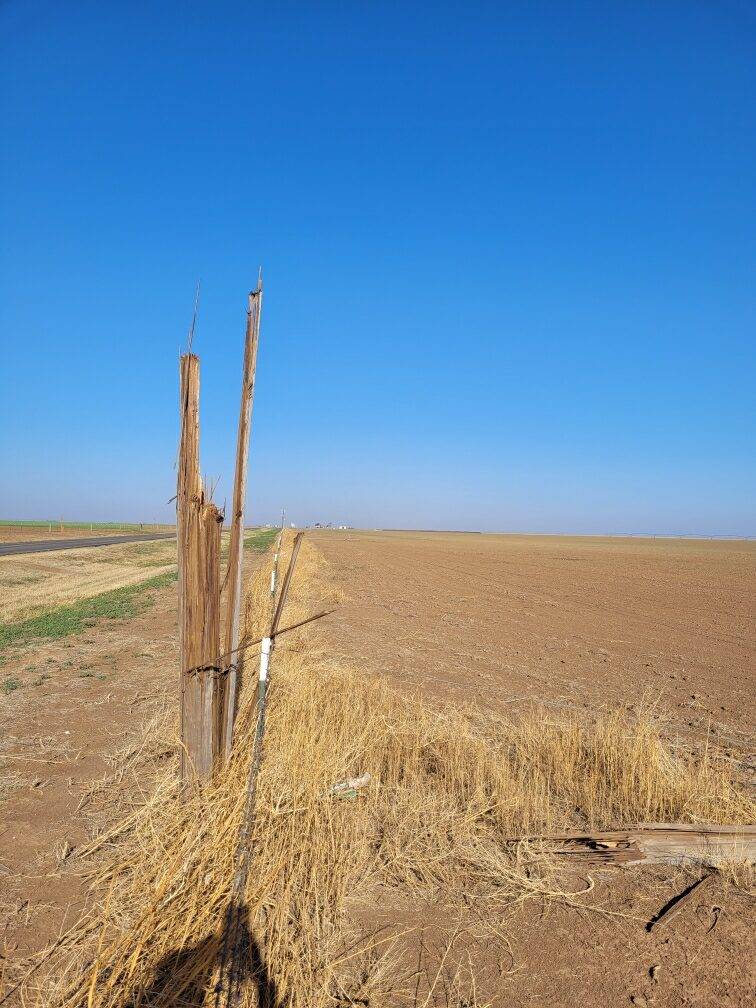
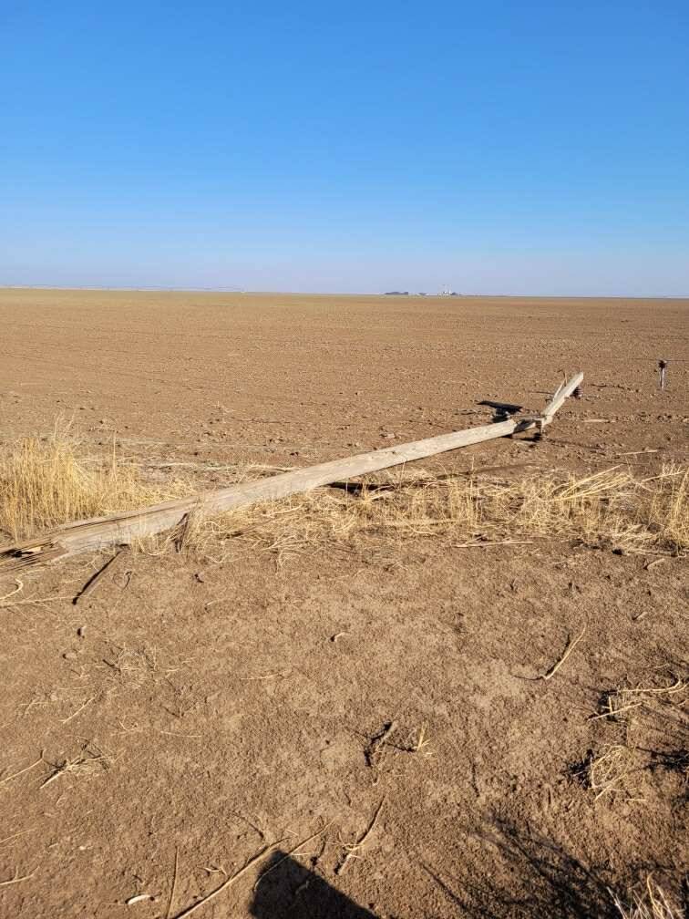
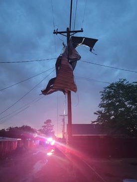
| Telephone pole damage from wind in Hereford (Credit: Deaf Smith Electric Cooperative) |
Telephone pole damage from wind in Hereford (Credit: Deaf Smith Electric Cooperative) |
Telephone pole damage from wind in Hereford (Credit: Deaf Smith Electric Cooperative) |
Telephone pole damage from wind in Hereford (Credit: Deaf Smith Electric Cooperative) |
 |
 |
 |
 |
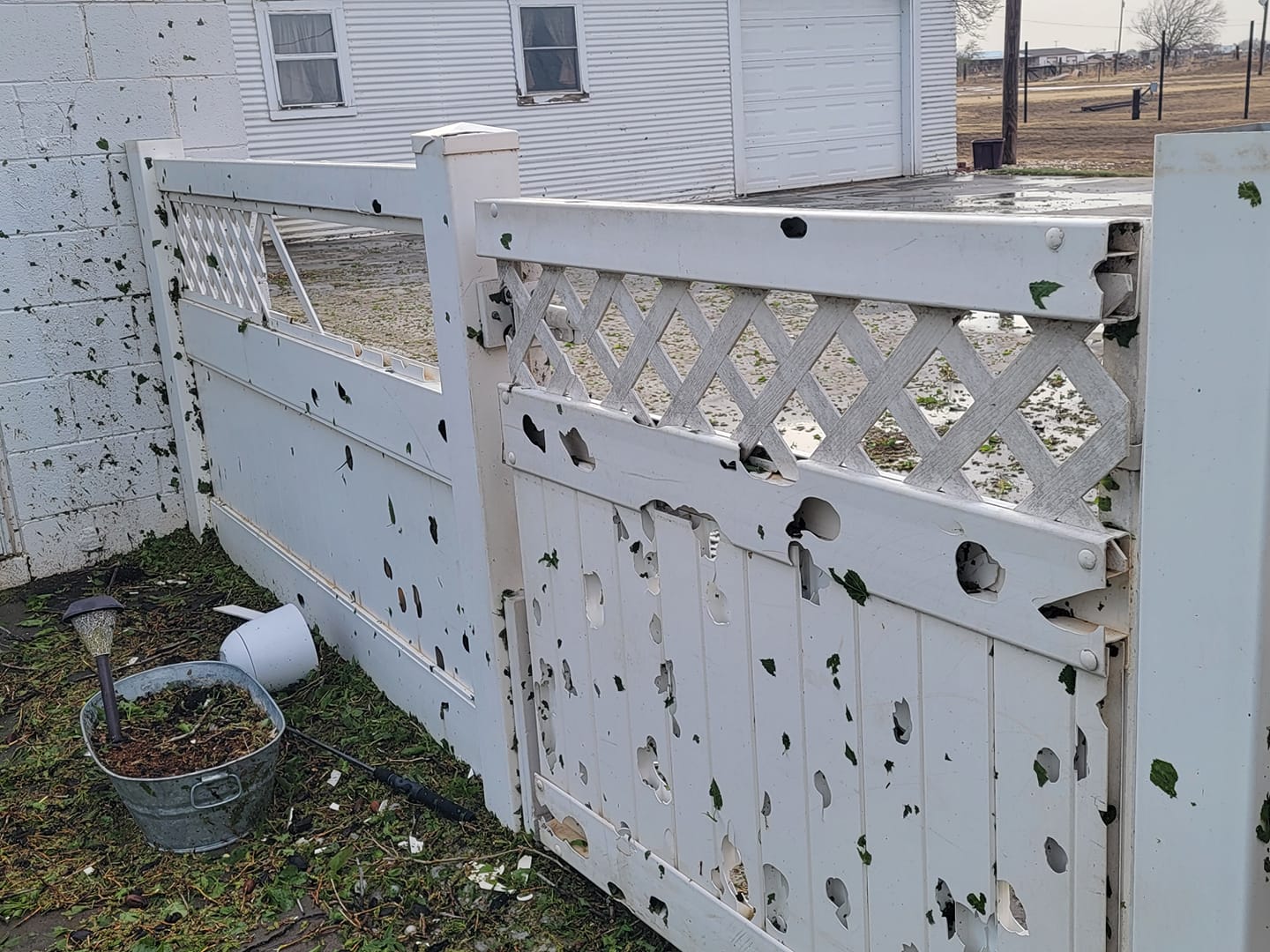
| Fence damage from hail in Hereford (Credit: Elaina Burkhalter) |
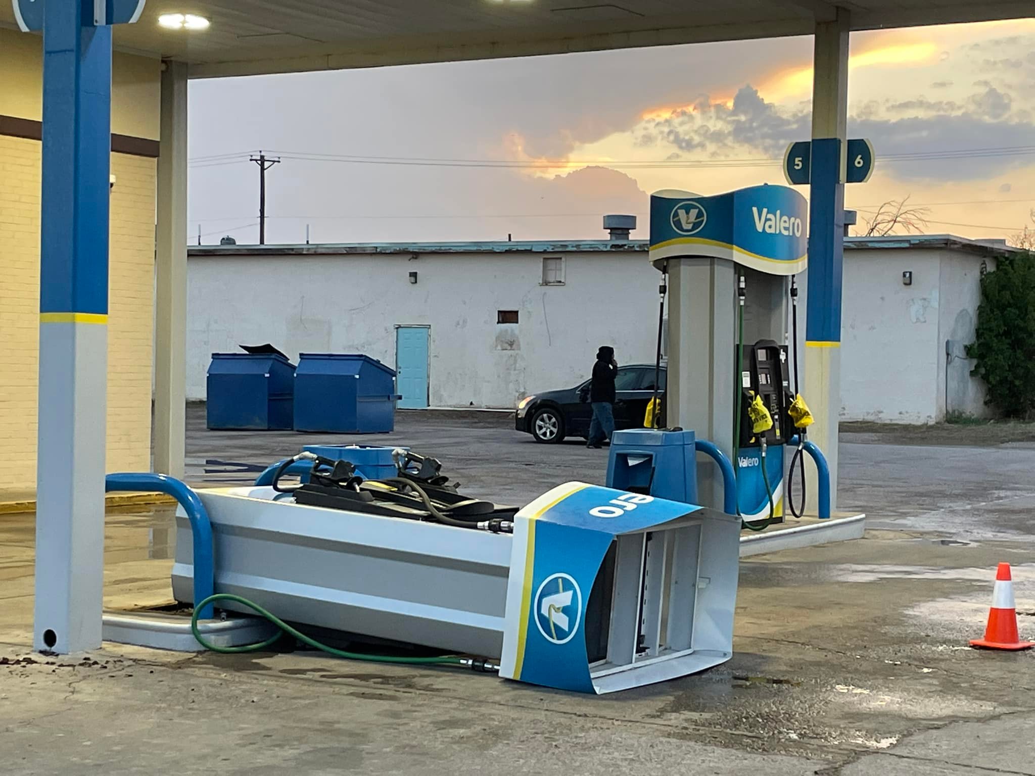
Gas station damage from wind in Hereford (Credit: Hereford Brand) |
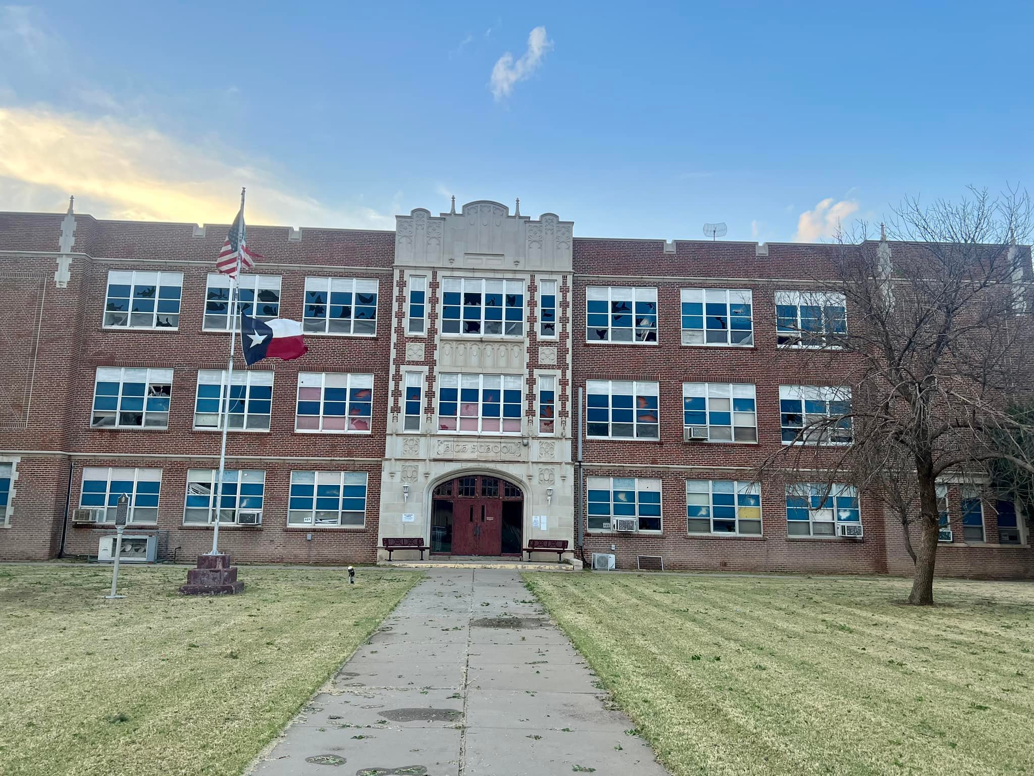
School damage from hail and wind in Hereford (Credit: Hereford Brand) |
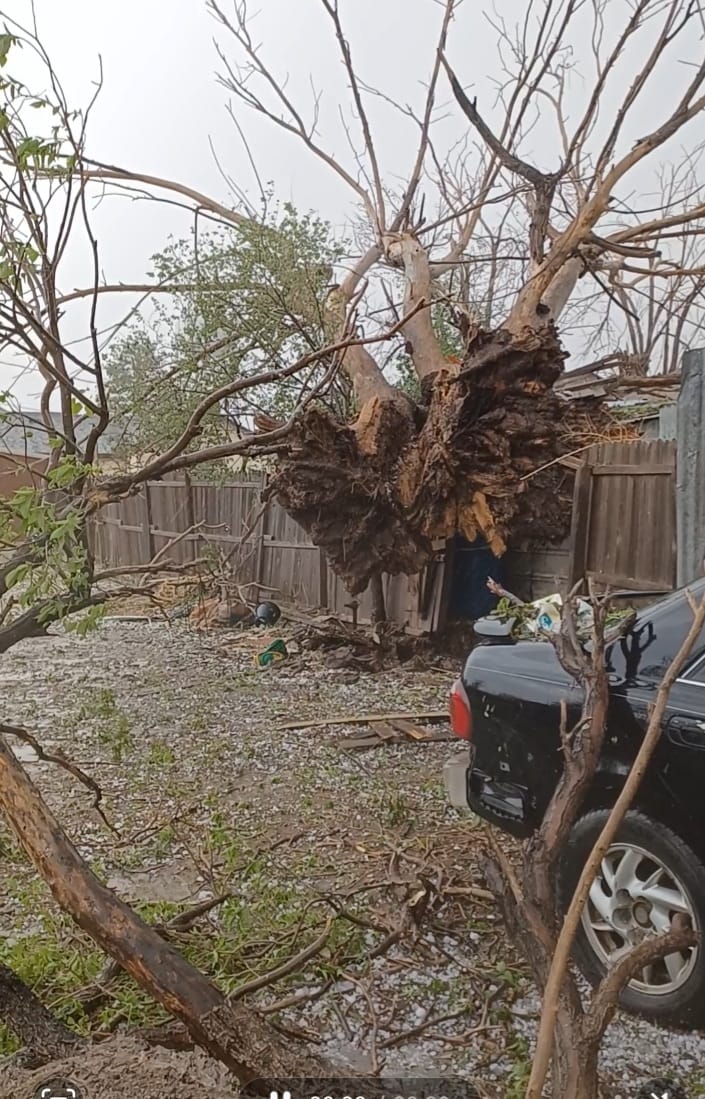
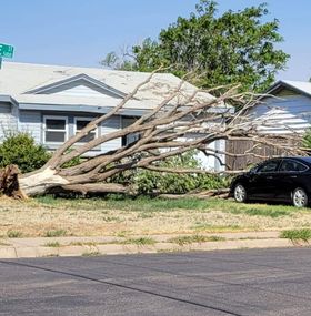
Tree damage from wind in Hereford (Credit: Tere Mena) |
 |
 |
 |
 |
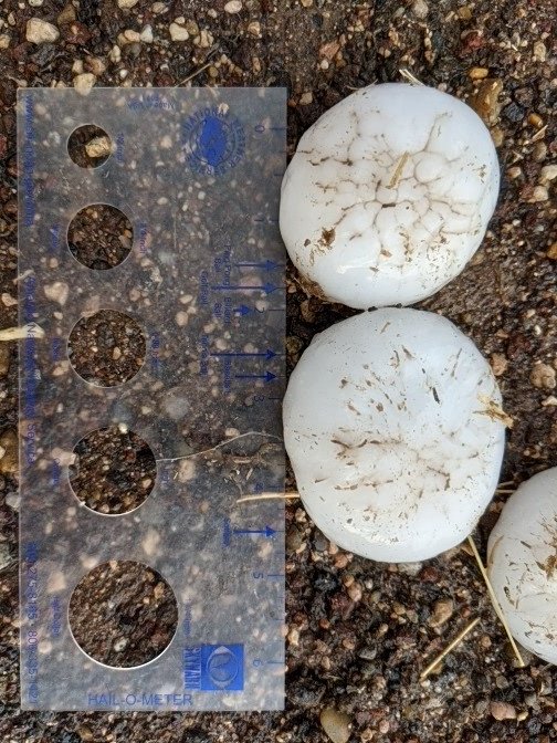
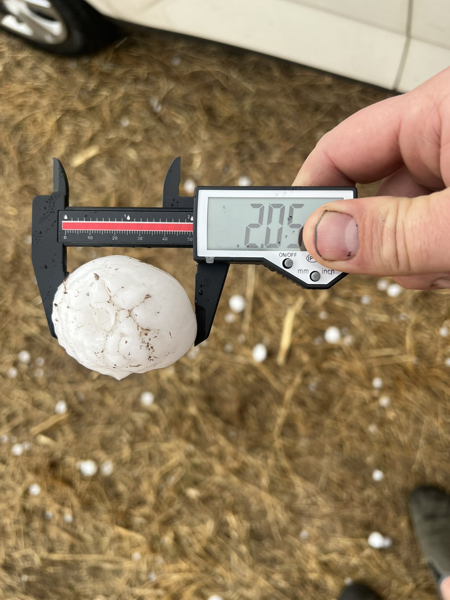
| Hen egg size hail near Dawn (Credit: Steve Thompson) |
Baseball size hail north of Dawn (Credit: Marcus Diaz) |
Tree damage from wind in Amarillo (Credit: Tiff West) |
Shed wrapped around a pole due to a landspout (Credit: Tonya Tate) |
Radar
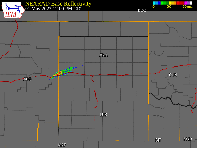 |
| Radar Imagery from May 1st at 12 PM CDT to May 2nd at 4 AM CDT |
Storm Reports
PRELIMINARY LOCAL STORM REPORT...SUMMARY
NATIONAL WEATHER SERVICE AMARILLO TX
1004 PM CDT MON MAY 2 2022
..TIME... ...EVENT... ...CITY LOCATION... ...LAT.LON...
..DATE... ....MAG.... ..COUNTY LOCATION..ST.. ...SOURCE....
..REMARKS..
0433 PM HAIL 16 NE ROMERO 35.89N 102.73W
05/01/2022 M0.75 INCH HARTLEY TX PUBLIC
0450 PM HAIL 1 NNW HARTLEY 35.90N 102.40W
05/01/2022 M1.00 INCH HARTLEY TX TRAINED SPOTTER
0458 PM HAIL 2 ENE DALHART 36.07N 102.48W
05/01/2022 M1.00 INCH DALLAM TX TRAINED SPOTTER
0506 PM HAIL 4 SW DALHART 36.02N 102.57W
05/01/2022 E1.75 INCH HARTLEY TX PUBLIC
0511 PM HAIL 1 NNW STRATFORD 36.35N 102.08W
05/01/2022 E1.00 INCH SHERMAN TX EMERGENCY MNGR
0515 PM HAIL 10 SW DALHART 36.03N 102.55W
05/01/2022 M1.25 INCH HARTLEY TX TRAINED SPOTTER
0519 PM HAIL 7 SSW DALHART 35.95N 102.57W
05/01/2022 M1.75 INCH HARTLEY TX TRAINED SPOTTER
0528 PM HAIL 1 SSE DALHART 36.05N 102.51W
05/01/2022 E1.00 INCH HARTLEY TX PUBLIC
REPORT FROM MPING: QUARTER (1.00 IN.).
0536 PM HAIL 3 SE DALHART 36.03N 102.48W
05/01/2022 E1.25 INCH HARTLEY TX TRAINED SPOTTER
0537 PM HAIL 1 SE DALHART 36.05N 102.50W
05/01/2022 M1.00 INCH HARTLEY TX PUBLIC
0618 PM HAIL 8 NNW BOOTLEG 34.95N 102.85W
05/01/2022 E1.25 INCH DEAF SMITH TX STORM CHASER
0633 PM HAIL 10 WSW SIMMS 34.99N 102.82W
05/01/2022 E1.50 INCH DEAF SMITH TX STORM CHASER
0635 PM TSTM WND GST 3 WSW DUMAS 35.85N 102.02W
05/01/2022 M58 MPH MOORE TX AWOS
AWOS STATION KDUX DUMAS (AWOS).
0635 PM TSTM WND DMG HEREFORD 34.83N 102.40W
05/01/2022 DEAF SMITH TX TRAINED SPOTTER
GAS PUMP AT GAS STATION BLOWN OVER ON TOP OF
A CAR, DAMAGE ALL OVER.
0639 PM TSTM WND GST 2 WNW HEREFORD 34.83N 102.42W
05/01/2022 M67 MPH DEAF SMITH TX MESONET
CORRECTS PREVIOUS TSTM WND GST REPORT FROM 2
WNW HEREFORD. MESONET STATION HEREFORD 2NW.
PEAK GUST OCCURRED AT 641 PM CDT. INITIAL
SEVERE GUST OCCURRED AT 639 PM CDT.
0640 PM TSTM WND GST 3 SE DUMAS 35.83N 101.93W
05/01/2022 M72 MPH MOORE TX MESONET
SEVERE THUNDERSTORM INFLOW MEASURED AT 3
SOUTHEAST OF DUMAS WEST TEXAS MESONET.
SEVERE GUSTS FROM 640 PM TO 654 PM CDT. PEAK
GUST AT 646 PM CDT.
0640 PM HAIL HEREFORD 34.83N 102.40W
05/01/2022 E1.75 INCH DEAF SMITH TX PUBLIC
CORRECTS REPORT AT BUSHLAND, SHOULD BE IN
HEREFORD.
0643 PM HAIL 1 WNW HEREFORD 34.83N 102.42W
05/01/2022 M2.50 INCH DEAF SMITH TX PUBLIC
GOLF BALL TO TENNIS BALL HAIL, WINDOWS ON
HOUSES BROKEN OUT.
0645 PM HAIL 9 N HEREFORD 34.95N 102.40W
05/01/2022 M1.75 INCH DEAF SMITH TX TRAINED SPOTTER
0655 PM HAIL 5 N DAWN 34.99N 102.20W
05/01/2022 M2.75 INCH DEAF SMITH TX STORM CHASER
0655 PM TSTM WND DMG 7 NW DAWN 34.98N 102.30W
05/01/2022 DEAF SMITH TX STORM CHASER
SEVERAL SNAPPED POWER POLES ALONG FM 1063.
0700 PM HAIL 5 N DUMAS 35.93N 101.96W
05/01/2022 M1.75 INCH MOORE TX LAW ENFORCEMENT
0701 PM TSTM WND GST 3 NNE UMBARGER 34.99N 102.08W
05/01/2022 M63 MPH RANDALL TX MESONET
MESONET STATION 76 UMBARGER 3NNE. SEVERE
GUSTS LASTED 2 MINUTES.
0717 PM HAIL 7 ESE BUSHLAND 35.13N 101.95W
05/01/2022 E1.00 INCH RANDALL TX NWS EMPLOYEE
REPORT FROM SOUTHWEST AMARILLO IN HILLSIDE
TERRACE.
0720 PM HAIL 3 E BUSHLAND 35.18N 102.01W
05/01/2022 M1.75 INCH POTTER TX PUBLIC
SMALL TREE LIMBS AROUND 1 TO 2 INCHES
DOWNED.
0720 PM HAIL 2 NNW BUSHLAND 35.21N 102.07W
05/01/2022 E2.50 INCH POTTER TX PUBLIC
0723 PM HAIL 5 W AMARILLO 35.22N 101.91W
05/01/2022 U1.75 INCH POTTER TX PUBLIC
REPORT FROM MPING: GOLF BALL (1.75 IN.).
0725 PM HAIL 5 W AMARILLO 35.22N 101.91W
05/01/2022 U1.50 INCH POTTER TX PUBLIC
REPORT FROM MPING: PING PONG BALL (1.50
IN.).
0725 PM TSTM WND GST 6 ENE AMARILLO 35.24N 101.72W
05/01/2022 M60 MPH POTTER TX ASOS
0725 PM HAIL 6 WNW AMARILLO 35.24N 101.92W
05/01/2022 M1.00 INCH POTTER TX TRAINED SPOTTER
0726 PM HAIL 8 WNW AMARILLO 35.28N 101.81W
05/01/2022 M2.75 INCH POTTER TX EMERGENCY MNGR
CORRECTS PREVIOUS HAIL REPORT FROM 6 N
AMARILLO. PCFD BISHOP HILLS.
0727 PM HAIL 8 WNW AMARILLO 35.26N 101.94W
05/01/2022 M1.75 INCH POTTER TX TRAINED SPOTTER
0728 PM TSTM WND DMG 1 SW AMARILLO 35.20N 101.83W
05/01/2022 POTTER TX EMERGENCY MNGR
POWER LINE DOWN.
0728 PM HAIL 3 E BUSHLAND 35.19N 102.01W
05/01/2022 E1.00 INCH POTTER TX EMERGENCY MNGR
TRACTOR TRAILER BLOWN OVER (I-40 & ARNOT
RD).
0730 PM HAIL 7 NNW AMARILLO 35.29N 101.88W
05/01/2022 E1.50 INCH POTTER TX PUBLIC
0730 PM HAIL 6 NW AMARILLO 35.26N 101.89W
05/01/2022 M1.00 INCH POTTER TX TRAINED SPOTTER
0734 PM TSTM WND GST 11 ESE VALLEY DE ORO 35.40N 101.92W
05/01/2022 M62 MPH POTTER TX MESONET
0737 PM TSTM WND GST 11 ESE VALLEY DE ORO 35.40N 101.92W
05/01/2022 M86 MPH POTTER TX MESONET
0744 PM HAIL 10 NW SANFORD 35.82N 101.64W
05/01/2022 M1.75 INCH MOORE TX TRAINED SPOTTER
0746 PM TSTM WND GST 7 E BORGER 35.66N 101.28W
05/01/2022 M60 MPH HUTCHINSON TX MESONET
0750 PM HAIL FELT 36.57N 102.78W
05/01/2022 M0.88 INCH CIMARRON OK EMERGENCY MNGR
0755 PM TSTM WND DMG 1E FRITCH 35.64N 101.60W
05/01/2022 HUTCHINSON TX PUBLIC
AS SEEN IN VIDEOS PROVIDED, A VERY SHORT
LIVED LANDSPOUT OCCURRED IN FRITCH WITH A
LOCATION INTERSECTION NEAR PALM AND SOUTH
RIDGELAND. MINOR DAMAGE OCCURRED.
SPECIFICALLY, A FEW SMALL TREE LIMBS WERE
DOWNED, AND THERE WAS DAMAGE TO THE METAL
ROOF OF A BARN AS WELL AS DAMAGE TO A SMALL
SHED THAT HAD BEEN LOFTED INTO A NEARBY
POWERLINE.
.png) 0755 PM TSTM WND GST 1 WNW FRITCH 35.65N 101.61W
05/01/2022 M60 MPH HUTCHINSON TX MESONET
0759 PM HAIL 2 W STINNETT 35.82N 101.48W
05/01/2022 M1.75 INCH HUTCHINSON TX EMERGENCY MNGR
0802 PM TSTM WND GST 1 WNW FRITCH 35.65N 101.61W
05/01/2022 M62 MPH HUTCHINSON TX MESONET
0803 PM HAIL STINNETT 35.82N 101.45W
05/01/2022 M1.50 INCH HUTCHINSON TX PUBLIC
0805 PM NON-TSTM WND GST 3 SE DUMAS 35.83N 101.93W
05/01/2022 M60 MPH MOORE TX MESONET
0807 PM TSTM WND DMG FRITCH 35.64N 101.60W
05/01/2022 HUTCHINSON TX EMERGENCY MNGR
TREE LIMBS DOWN, SMALL BUILDING DAMAGED, AND
DEBRIS ON A POWERLINE.
0810 PM TSTM WND GST 1 SSW PANHANDLE 35.33N 101.39W
05/01/2022 M64 MPH CARSON TX MESONET
0918 PM HAIL 6 E CHANNING 35.68N 102.22W
05/01/2022 M1.75 INCH HARTLEY TX PUBLIC
1019 PM TSTM WND DMG 3 NE MIAMI 35.72N 100.60W
05/01/2022 ROBERTS TX LAW ENFORCEMENT
CAR PORT PUSHED OVER AND METAL OUTBUILDING
DAMAGED.
1200 AM HAIL 1 SSW DUMAS 35.85N 101.97W
05/02/2022 M1.75 INCH MOORE TX TRAINED SPOTTER
1200 AM HAIL DUMAS 35.86N 101.96W
05/02/2022 M1.75 INCH MOORE TX EMERGENCY MNGR
1202 AM HAIL 1 SE DUMAS 35.85N 101.95W
05/02/2022 M1.75 INCH MOORE TX PUBLIC
0130 AM TSTM WND GST 2 N BORGER 35.69N 101.40W
05/02/2022 M58 MPH HUTCHINSON TX ASOS
0755 PM TSTM WND GST 1 WNW FRITCH 35.65N 101.61W
05/01/2022 M60 MPH HUTCHINSON TX MESONET
0759 PM HAIL 2 W STINNETT 35.82N 101.48W
05/01/2022 M1.75 INCH HUTCHINSON TX EMERGENCY MNGR
0802 PM TSTM WND GST 1 WNW FRITCH 35.65N 101.61W
05/01/2022 M62 MPH HUTCHINSON TX MESONET
0803 PM HAIL STINNETT 35.82N 101.45W
05/01/2022 M1.50 INCH HUTCHINSON TX PUBLIC
0805 PM NON-TSTM WND GST 3 SE DUMAS 35.83N 101.93W
05/01/2022 M60 MPH MOORE TX MESONET
0807 PM TSTM WND DMG FRITCH 35.64N 101.60W
05/01/2022 HUTCHINSON TX EMERGENCY MNGR
TREE LIMBS DOWN, SMALL BUILDING DAMAGED, AND
DEBRIS ON A POWERLINE.
0810 PM TSTM WND GST 1 SSW PANHANDLE 35.33N 101.39W
05/01/2022 M64 MPH CARSON TX MESONET
0918 PM HAIL 6 E CHANNING 35.68N 102.22W
05/01/2022 M1.75 INCH HARTLEY TX PUBLIC
1019 PM TSTM WND DMG 3 NE MIAMI 35.72N 100.60W
05/01/2022 ROBERTS TX LAW ENFORCEMENT
CAR PORT PUSHED OVER AND METAL OUTBUILDING
DAMAGED.
1200 AM HAIL 1 SSW DUMAS 35.85N 101.97W
05/02/2022 M1.75 INCH MOORE TX TRAINED SPOTTER
1200 AM HAIL DUMAS 35.86N 101.96W
05/02/2022 M1.75 INCH MOORE TX EMERGENCY MNGR
1202 AM HAIL 1 SE DUMAS 35.85N 101.95W
05/02/2022 M1.75 INCH MOORE TX PUBLIC
0130 AM TSTM WND GST 2 N BORGER 35.69N 101.40W
05/02/2022 M58 MPH HUTCHINSON TX ASOS
Rainfall Map
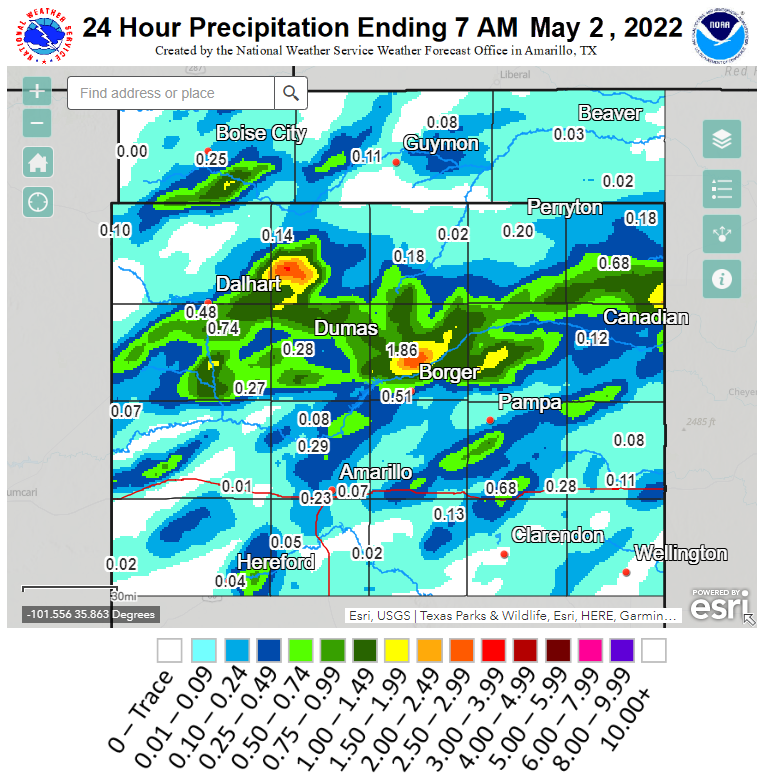
| 24 Hour Precipitation Totals Ending at 7 AM CDT May 2nd, 2022 |
Environment
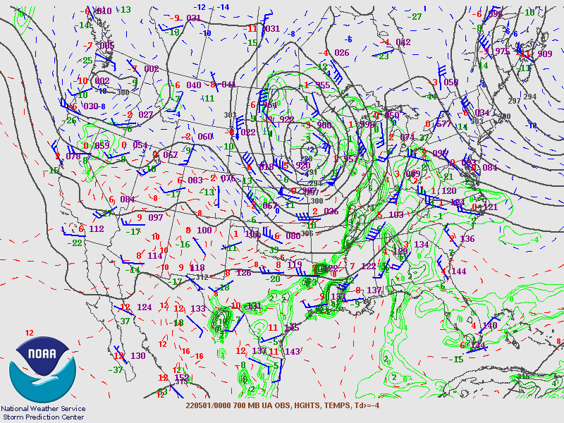
A 250mb shortwave and 500mb closed low brought an upper level jet into West Texas Sunday afternoon and evening with large scale ascent to assist in thunderstorm development. A sharp surface dryline setup in eastern New Mexico with isolated to scattered thunderstorm development along the boundary before pushing northeast into West Texas into the evening hours. Low level moisture was not very impressive through the day, but began to increase a bit as storms developed during the late afternoon hours.
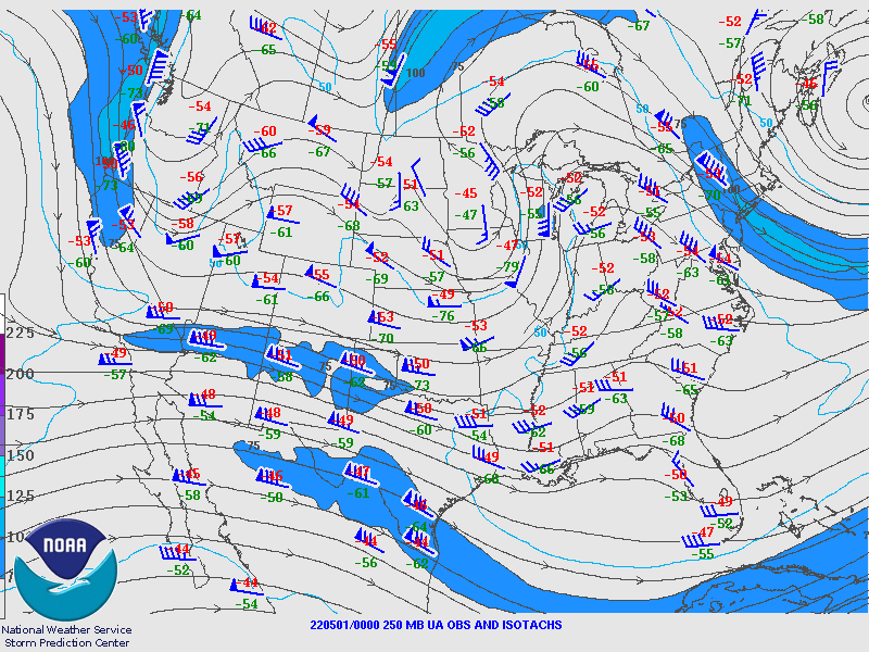 |
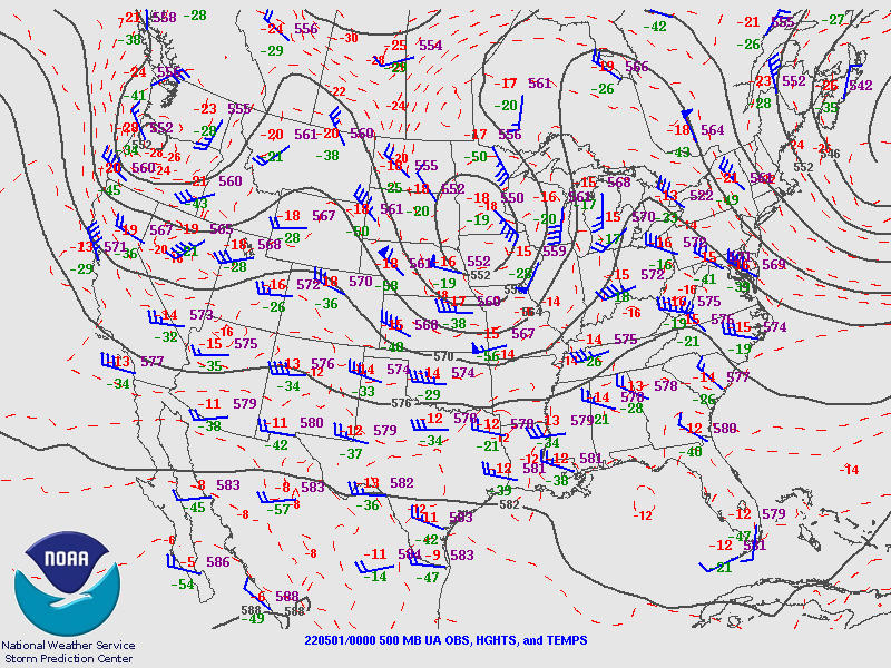 |
| 250mb Height Analysis at 7 PM on May 1, 2022 | 500mb Height Analysis at 7 PM on May 1, 2022 |
 |
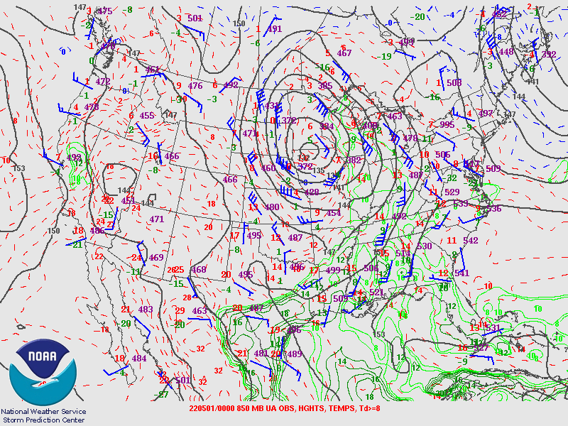 |
| 700mb Height Analysis at 7 PM on May 1, 2022 | 850mb Height Analysis at 7 PM on May 1, 2022 |
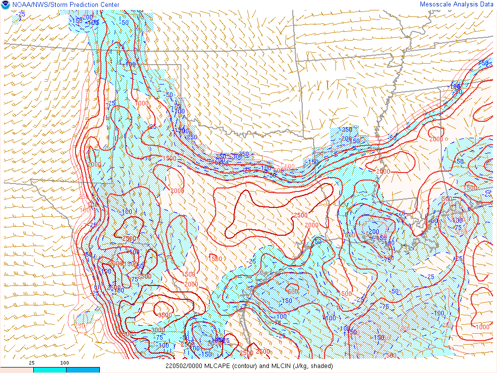
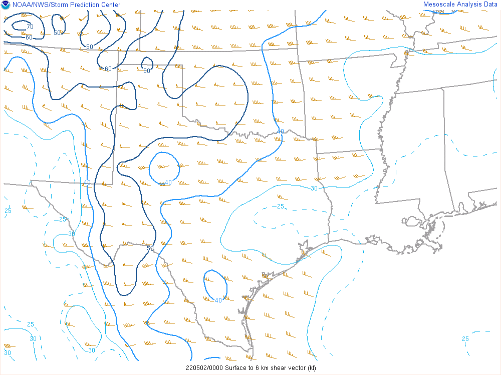
The environment Sunday evening was very heavily sheared with 50 to 60 knot 0-6km bulk shear, which was indicative of strongly tilted updrafts and a higher probability of storms becoming bowed with powerful wind signatures. Mixed layer convective available potential energy was around 500-1500 J/kg with mid-level lapse rates of around 7 to 8.5 C/km, which supported supercells. In order to maintain these vigorous supercells, the inflow also had to be significant with much of the severe wind gusts being out of the southeast (inflow winds) and ingested into the storms.
 |
 |
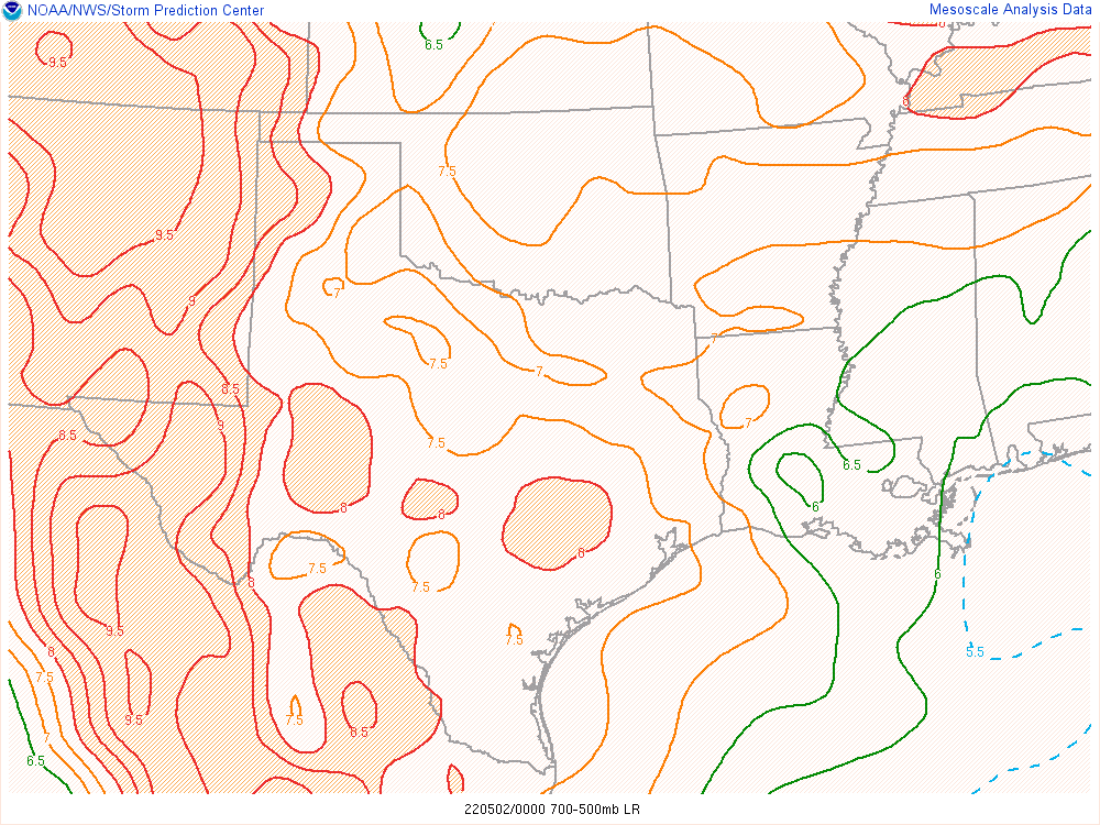 |
| Mixed Layer Convective Available Potential Energy (MLCAPE) at 7 PM on May 1, 2022 | 0-6km Bulk Wind Shear at 7 PM on May 1, 2022 | Mid-level Lapse Rates at 7 PM on May 1, 2022 |
 |
Media use of NWS Web News Stories is encouraged! Please acknowledge the NWS as the source of any news information accessed from this site. |
|

