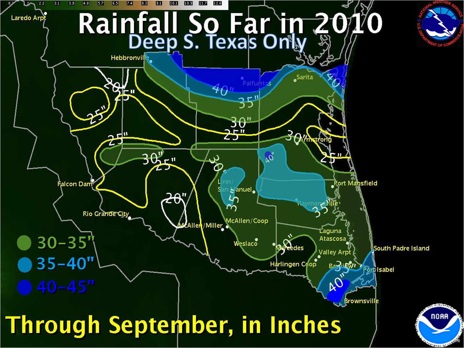
 Year to date rainfall, through September 2010. This chart is virtually unchanged for the calendar year, as rainfall after September 28th was less than a quarter of an inch in all but the Rio Grande City area, where nearly three quarters of an inch fell. |
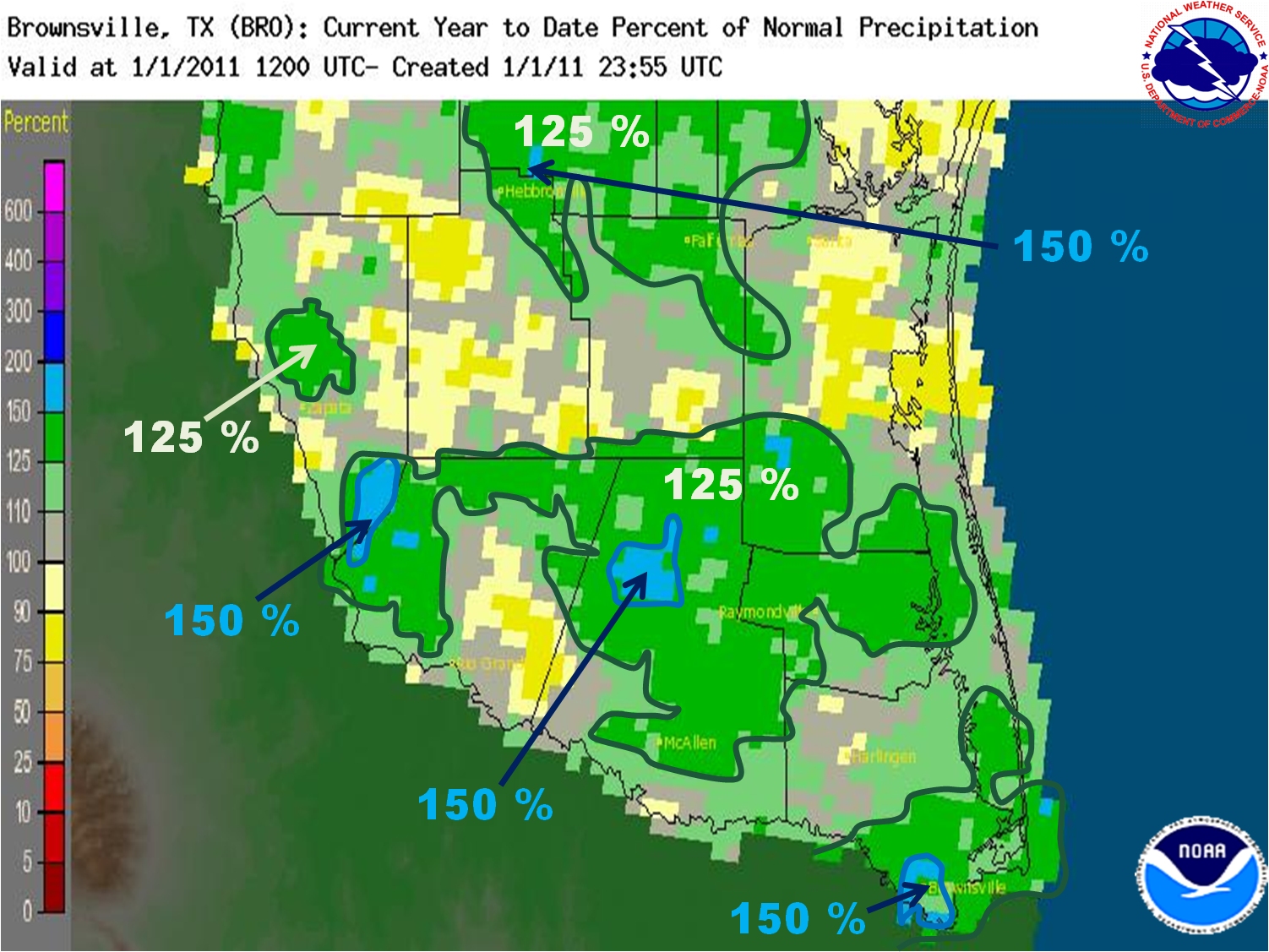 Despite little or no rainfall from October through December, the amount of rainfall across most of Deep South Texas remained at or above 100 percent. Exceptions included much of Jim Hogg, a portion of Eastern Starr, and a portion of the King Ranch east of Highway 77. |
From El Niño to La Niña; Floods to Drought: 2010 Was One Wild Weather Ride Across the Rio Grande Valley |
|
| July to September: The Rio Grande Flood of 2010; Summer’s Wet Finish | |
|
Alex may have weakened to a depression and then dissipated during the first couple days of July, but his legacy was just beginning for the Lower Rio Grande Valley. An ominous sign was already evident on the 1st, when the cyclone brought rich moisture toward the natural barrier of the Sierra Madre in northern México. The large envelope of moisture and energy wrung out 20 to 35 inches of rain along the front range west of Monterrey, ultimately turning the normally dry and placid Santa Catarina River into a boiling rage of destructive water, mud, and debris which left hundreds of millions of dollars in devastation, killing at least a dozen in Nuevo León State. In South Texas, the remaining deep moisture, very unstable atmosphere, and weak shear axis of energy was enough to generate a rotating thunderstorm near Hebbronville, which dropped a 90 to 100 mph tornado in Hebbronville which tracked nearly 2 miles and damaged more than $1 million in property along its path. The remains of Alex meandered across the Sierra Madre through at least July 6th, with continued flow of deep moisture perpendicular into the northern peaks, dropping persistent rainfall of at least 5 to 10 inches per day in portions of Coahuila and Chihuahua province. By the time the rain finally tapered off, radar composites and other estimates suggested perhaps 50 inches or more had fallen. The rain had to flow somewhere, and that somewhere became the Rio Grande Basin. In the mean time, perhaps adding some insult to injury, Tropical Depression Number 2 formed in the west central Gulf on July 7th, and would quickly scoot west northwest with little intensification, making a direct hit on South Padre Island at around 10 AM on the 8th. Impacts from Tropical Depression 2 were minimal; however, additional rainfall would exacerbate the Rio Grande Flood of 2010, which coincidentally began on the same day. The Rio Grande Flood of 2010, a result of dam releases from Mexican tributaries and along the Rio Grande at Amistad and Falcon International Reservoirs, began roughly on July 8th and would continue until August 10th at Rio Grande City (extending into Hidalgo County). The continuous release of up to 60,000 cubic feet of water per second would require activation of the U.S. Lower Rio Grande Flood Control Project, or "floodways", for the balance of July and into the latter half of August. This was the first activation since 1988 (remnants of Hurricane Gilbert), and produced the highest crests on the unprotected portion of the River in Starr and Hidalgo County in nearly 40 years (1971). A full report on the Rio Grande Flood in the Lower Rio Grande Valley can be found here. Additional, locally moderate rain would fall just before month’s end, with many locations finishing in among the top twenty wettest since records were kept. July 2010 was in stark contrast with July 2009, remembered for record heat and virtually no cooling rains, area wide. Summer swelter, in the form of oppressive heat and humidity, would dominate August. The lack of significant rainfall would allow the Rio Grande Basin to steadily drain, eventually allowing the floodways to empty and river levels to slowly decrease. Aside from a well viewed landspout tornado south of Port Isabel, the heat came full force toward the end of the month, with 100°F temperatures ruling on the 23rd and 24th. In fact, for a second straight year, August ranked among the hottest all time for many locations in Deep South Texas, with Brownsville shattering its all time record dominated by an average high of a McAllen–like 95.9°F! September arrived with a surprising punch, as small but powerful Tropical Storm Hermine literally developed overnight on Labor Day Sunday and made a direct hit on Brownsville, Harlingen, and Raymondville just 24 hours later, creating a midnight madness of heavy winds gusting near hurricane force and torrential, sideways rain as the holiday weekend came to a close. The three hour tempest left millions in wind damage, 55 thousand residents powerless, and some farm fields flooded yet another time in a busy year. Hermine’s strike, raking Cameron and Willacy County but leaving Hidalgo County unscathed, was an omen for yet another significant weather event less than two weeks later. A series of upper level disturbances moving onshore from the Gulf lifted deep tropical moisture into numerous showers and thunderstorms yet again, favoring communities close to the coast. Between September 17th and 22nd, up to 10 inches fell in Cameron County, with more than 4 inches across all but southern Hidalgo County stretching into central Starr and portions of Zapata and Jim Hogg County. The same system produced a convective complex in northern Nuevo Leon State southwest of the Zapata/Starr County line. The additional rainfall would return high water levels to the Rio Grande Basin, forcing dam releases at Falcon, and Marte Gomez southwest of Starr County, resulting in reactivation of the Floodway System from late September into October. September 2010 would leave the Valley as green as can be, with coastal communities from Cameron to Kenedy County receiving up to 300 percent of average for the month. For the nine month period ending September 30th, some locations in Cameron and Hidalgo County would have already reached more than 200 percent of the average year to date rainfall. And, the pool level at Falcon International Reservoir remained well above conservation level, ensuring plenty of water in reserve for the following year’ irrigation, livestock, and downstream human needs. That is, assuming drought could stay away long enough... |
|
| October to December: Floods to Fire: La Niña, Teleconnections Turn Spigot Off | |
|
On September 27th, a dry cool front swept well into Mexico, ending the primary threat from tropical cyclones in 2010. At the same time, La Niña was rapidly increasing toward moderate to near strong levels, and the Arctic Oscillation was headed negative soon after. With no El Niño subtropical jet available to tap deep tropical moisture, the forecast became clear for the rest of the year: Frequent dry fronts, little or no rain, and a rapid increase in short term drought due to very dry air masses and moisture wicking wind. Sure enough, October was a beautiful transition month, with plenty of sunshine and only a spot of decent rain with a mid month front across Rio Grande City. No rain fell in the Lower Rio Grande Valley in October – or nearly all of November for that matter. The only story of interest in November was the temperature yo–yo. While the month was decidedly mild, there were large temperature swings, most notably between Thanksgiving Day and Black Friday morning, when "feels like" temperatures dropped from the lower 90s into the upper 30s in only 18 hours. Mariners might beg to differ, as November featured many days with dangerous seas and Gale Force wind gusts. Most unusual was the early month Gale, formed when a vigorous upper level disturbance closed off in the western Gulf, forming a surface Gale Center and producing several days of hazardous wind and seas in the Gulf despite splendid weather on land. December began on fire, literally, when relative humidity near 10 percent combined with recently cured, and highly loaded from the summer growth, fine fuels of grass and brush to rapidly spread a fire started by sparks from farm equipment in southwest Brooks County. Numerous small fires would be reported from late November through the end of the year, as a number of locations would not see wetting rain. After Deep South Texas was practically crying "uncle" after too much rain through September, the final three months of the year broke long standing records, some originally set during the start of the early drought period in 1950. A wild year, indeed. Back To Page 1 |
|

