HOME
FORECAST
Local
Graphical
Aviation
Marine
Rivers and Lakes
Hurricanes
Severe Weather
Fire Weather
Sunrise/Sunset
Long Range Forecasts
Climate Prediction
Space Weather
PAST WEATHER
Past Weather
Astronomical Data
Certified Weather Data
SAFETY
INFORMATION
Wireless Emergency Alerts
Weather-Ready Nation
Brochures
Cooperative Observers
Daily Briefing
Damage/Fatality/Injury Statistics
Forecast Models
GIS Data Portal
NOAA Weather Radio
Publications
SKYWARN Storm Spotters
StormReady
TsunamiReady
Service Change Notices
EDUCATION
NEWS
SEARCH
Search For
NWS
All NOAA
ABOUT
About NWS
Organization
For NWS Employees
National Centers
Careers
Contact Us
Glossary
Social Media
NWS Transformation
Local forecast by
"City, St" or ZIP code
Sorry, the location you searched for was not found. Please try another search.
Multiple locations were found. Please select one of the following:
Location Help
News Headlines
New: August-October 2026 Outlook - Hotter Than Normal And Mainly Dry Conditions Are Expected To Continue; Could Turn Wetter Towards The Fall; Heat Risk, Drought, Fire Weather, And Water Supply Issues Remain In Focus
WE ARE HIRING: NWS Brownsville/Rio Grande Valley is officially hiring a GS-5/7/9 Meteorologist. Apply today at USAJobs!
Notice: Rio Grande City NOAA Weather Radio Remains Out of Service Until Further Notice
Check Out the 2026 Rio Grande Valley/Deep South Texas Hurricane Guide
Guia de Huracanes 2026 del Valle del Rio Grande/Extremo Sur de Texas
The 2026 Hurricane Season is Here! Are You Ready? Know Your Risk, Check Your Plans, Restock Your Kits, and More
Additional Headlines
Customize Your
Weather.gov
Enter Your City, ST or ZIP Code
Remember Me
LOADING...
Brownsville/Rio Grande Valley, TX
Weather Forecast Office
Menu of 2010 significant weather events for Deep South Texas and the Lower Rio Grande Valley
Weather.gov
>
Brownsville/Rio Grande Valley, TX
> Menu of 2010 significant weather events for Deep South Texas and the Lower Rio Grande Valley
Current Hazards
Submit a Storm Report
Briefing Page (National)
Outlooks
Severe Weather Text
Current Conditions
Observed Precipitation
Satellite
Surface Observations
Surface Obs (clickable map)
Tides and Currents - Texas
CoCoRaHS Texas
Text Observations
RGV Hourly Detailed Weather Roundup Text Product
Radar
Local Standard Radar (Low Bandwidth)
Regional Standard Radar (Low Bandwidth)
Corpus Christi (Low Bandwidth)
Austin/San Antonio Standard Radar (Low Bandwidth)
Forecasts
Probabilistic Precipitation
Forecaster's Discussion
Fire
Hourly View
Marine
Probabilistic Snow and Ice
SPI Tides
Wave Prediction System
Graphical
Aviation
Tropical
Beach
Surf
Drought
Text Forecasts
Winter Storm Severity Index (WSSI - Interactive Texas Map)
Winter Storm Severity Index (Rio Grande Valley Static Image)
Model Guidance
Winter Probabilistic Precipitation Forecasts
Rivers and Lakes
*New* National Water Prediction Service (NWPS)
*New* NWPS - Local View
Climate and Past Weather
Climate Prediction
Drought
Past Events
Seasonal Outlooks
Tropical Cyclone Reports
Local Programs
Get Prepared!
Severe Weather Drill
Outreach
Research
RGV Skywarn
Newsletter
Data Program
User Guides
Jetstream Online Weather School
About Us
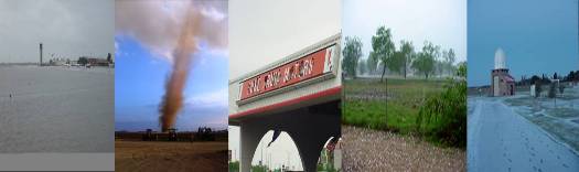
2010 Notable Weather Events
for Deep South Texas and the Rio Grande Valley
Events are listed from most recent to earliest
January 7th, 2011:
Annual Summary, 2010 – From Floods to Fires, 2010 Had it All
Early December:
Extremely Low Humidity Aids Wildfire Growth at Encinitos (Burns) Ranch
End of November:
A Brief Review of the 2010 Hurricane Season
October:
Return of the Dry: Spigot Turned Off After Wet September
September/October:
Reservoir Releases Force Floodway Diversion for 2nd Time
September:
Hermine, Tropical Waves Soak the Valley
September 17th-22nd:
Soaking Rains Flood Cameron County
September 6th-7th:
Midnight Madness – Hermine Brings Damaging Wind and Rain
August:
If You Thought August Was Hot, You Were Correct
August 23-24:
Hottest Temperatures Wait Until Late Summer
August 12th:
Landspout Seen By Many near Port Isabel
August 1st:
July: From 2009 Famine to 2010 Feast
July 9th-August 13th:
Major River Flooding along Rio Grande in Starr, Hidalgo County
July 8th:
Tropical Depression #2: More Bark than Bite: Some Rain, High Tides, Little Wind
June 29th – July 1st:
Hurricane Alex: Flooding Rains, Tidal Surge, but Limited Damage
June 7th:
Microburst Destroys Residences in Donna Colonia
; Hail and Lightning Follow
June 1st:
April/May 2010: Warm, Humid, but Green
(i.e., No Drought and Wildfire Concerns)
May 18th:
Morning Thunderstorms Bring Flooding Rains, Damaging Wind, and Large Hail to the RGV
April 12th-18th:
Too Much of a Good Thing? Heavy Rains Lead to Flooding
March 21-22:
Record Low Temperatures Defy the Spring Equinox
End of February:
Wet and Cool Was the Rule: El Niño, Teleconnections Make Winter 2009/10 Notable
February 18–19:
Locally Heavy Rainfall Douses Eastern Cameron County
February 2–4:
Soaking Rains and Mild Temperatures bring some Green
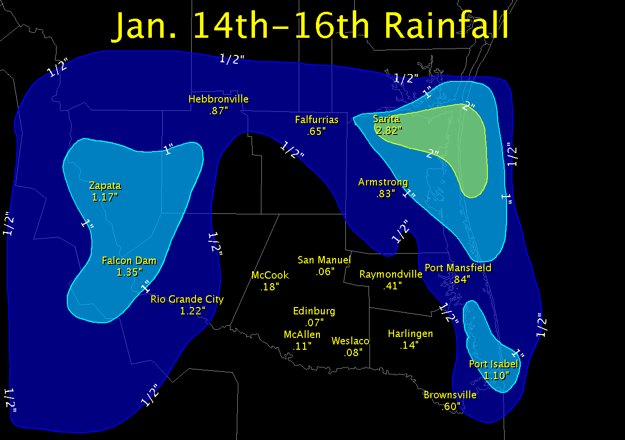
January 14–15:
Welcome Rains Hug Coast and Reach the Plains, but largely miss Valley
January 8–10:
"Polar Express" Rolls into Valley with Chill, Hard Freezes
Follow us on X
Follow us on Facebook
Follow us on YouTube
BRO RSS Feed

