Overview
|
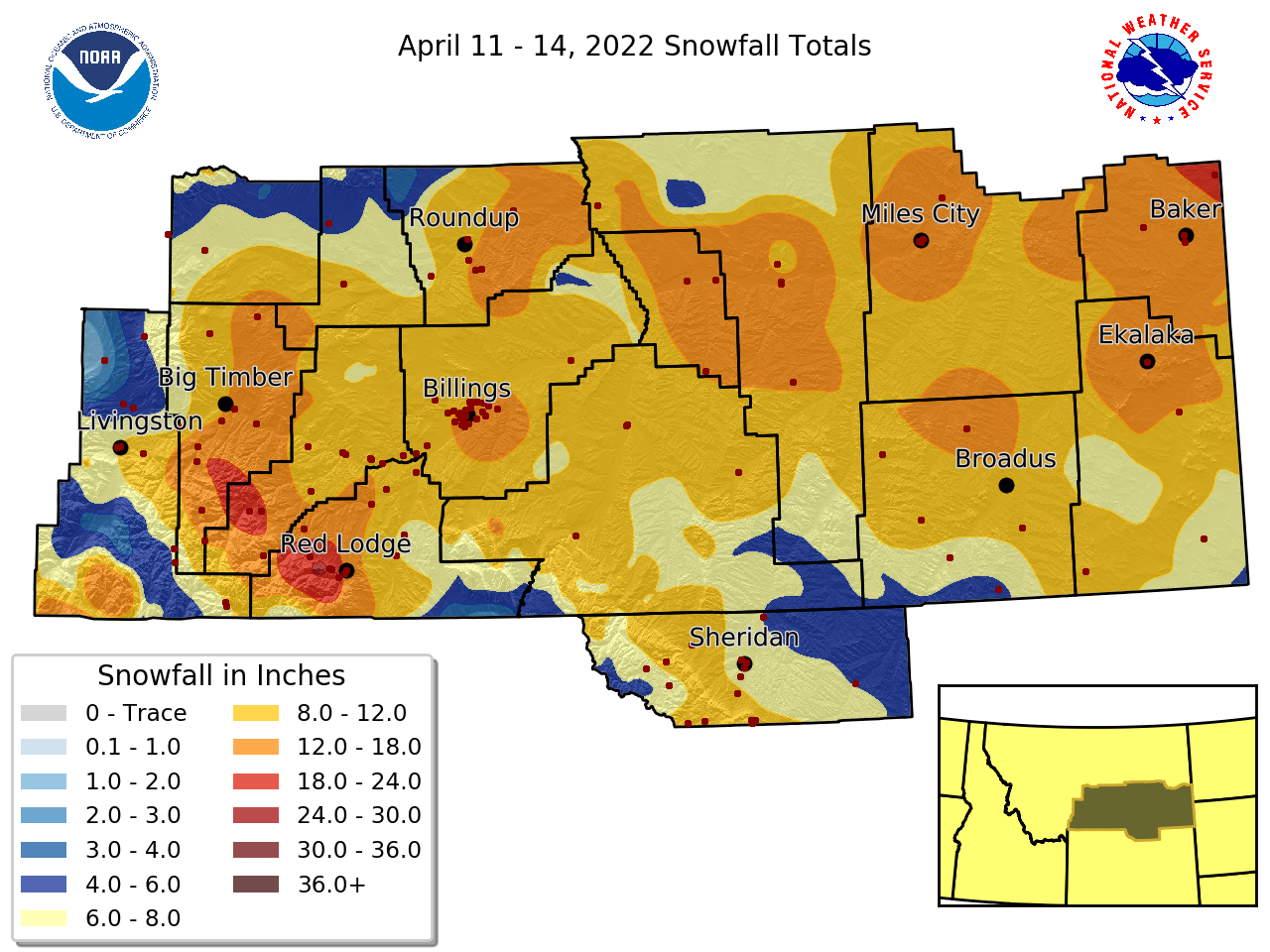
Snow began on the evening of Monday April 11th, impacted much of our west and central parts with heavy snow into Tuesday the 12th, and evolved into a blizzard for southeast Montana that lasted into Thursday April 14th. The storm had wide-ranging and long duration impacts to southcentral/southeast Montana and northern Wyoming. Most locations (with the exception of the Shields River and Paradise Valleys) received 8-15 inches of snowfall, while some areas east of Billings saw up to around 20 inches and the Beartooth and Red Lodge Foothills around two feet. |
 |
Snow/Cold
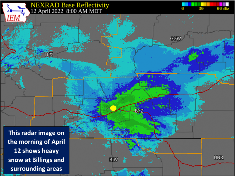
SNOW AT BILLINGS: Snowfall during the morning of April 12th was particularly heavy in the city of Billings. Snowfall rates of 2-3”/hour were observed, and snow piled up quickly. Approximately 10-12 inches fell between roughly 6 am and noon. Total snowfall at the Billings Airport on the 12th ended up being a whopping 13.9 inches. This was the heaviest single day total in April since 1955, and the 6th greatest single day total on record (for any time of year). Additionally, the snow depth of 13 inches observed at the airport on the morning of the 13th was the greatest depth on record so late in the spring.
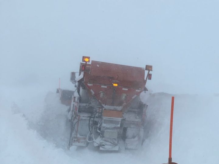
IMPACTS: The combination of heavy snowfall and strong winds caused significant blowing and drifting snow, especially over southeast Montana where winds were strongest. Some livestock were lost due to the snow, cold and wind. Several school districts closed schools for the day on Tuesday and/or Wednesday. Road closures delayed truck travel across much of the area. The following highways were closed for significant periods of time:
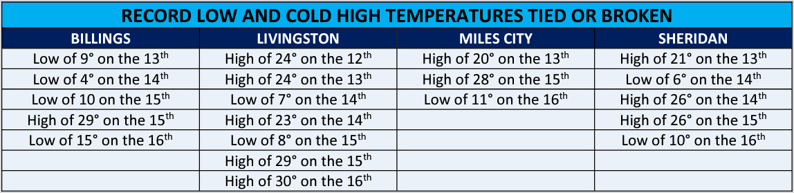
RECORD COLD: An unseasonably cold air mass settled over the region during the snowstorm and lasted through the week. Many daily record low and cold high temperatures were broken from the 13th through the 16th. Some locations even fell below zero, including Melville (-10°), Springdale (-7°), Columbus (-6°), Red Lodge (-4°) and Bridger (-2°). The lows of 4° at Billings and 7° at Livingston on the morning of the 14th were the coldest on record so late in the spring. The following table is a summary of records broken or tied at our four main climate stations during the cold snap.
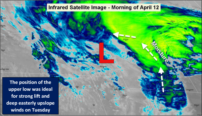
METEOROLOGY: A cold front on April 9th followed by a chilly air mass across the region on the 10th and 11th were important components to this winter storm, as relatively cold air was already in place when the Pacific system (and even colder Canadian air) arrived. The combination of strong upper level ascent, deep easterly (upslope) winds and temperatures favoring dendritic snow growth led to intense snowfall rates on the night of the 11th and morning of the 12th.
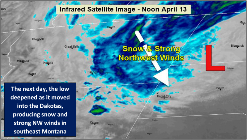
The upper level low deepened and tracked slowly as it moved from Wyoming into the Dakotas, and this was responsible for the long-duration blizzard conditions that occurred in southeast Montana (as well as northeast Montana and most of North Dakota). Overall, the strength, duration and magnitude of cold associated with this spring winter storm made it an event for the history books.
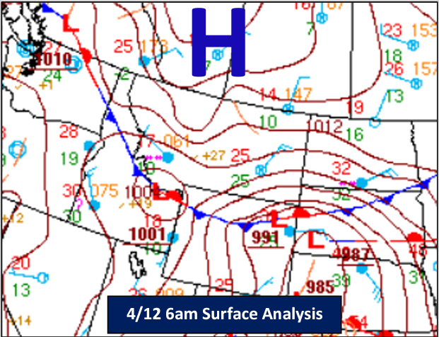
The surface analysis on the right shows cold high pressure surging out of Canada as the storm system moved from southern Idaho into Wyoming. This is an ideal scenario for heavy snow in southern Montana and northern Wyoming.
Radar & Satellite
 |
 |
 |
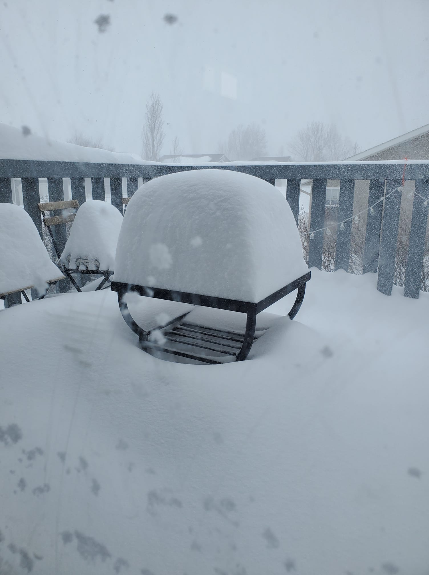
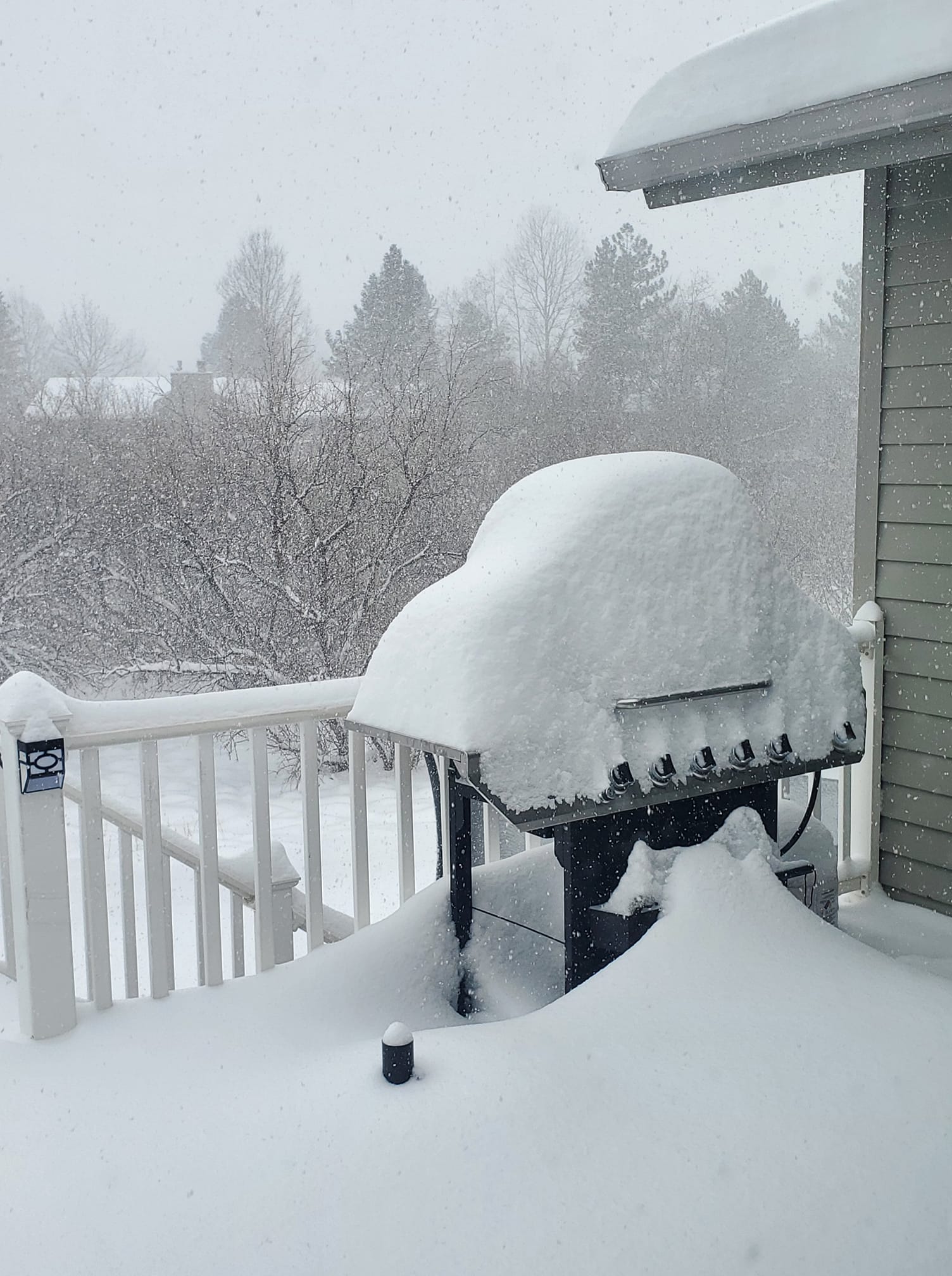
Photos & Video
|
 |
 |
 |
| Time lapse of the snow at the Billings NWS Office | Snow in Billings Heights by Juniper Bramhall | Snow in Alkali Creek by Whitney Paige Cook | Highway 7 between Baker and Ekalaka by Fallon County DES |
Storm Reports
NOUS45 KBYZ 141847
PNSBYZ
MTZ029>034-036-037-040-042-056>058-063>068-138-139-141-169>173-228-235-WYZ198-199-150700-
Public Information Statement
National Weather Service Billings MT
1247 PM MDT Thu Apr 14 2022
...FINAL WINTER STORM SUMMARY...
...FOR EVENTS THAT OCCURRED FROM 1000 PM MON APR 11 2022
THROUGH 1200 PM THU APR 14 2022...
Notes: Location of reports are referenced from city center.
Snowfall reports from SNOTEL sites are estimated.
...BIG HORN COUNTY...
***** Storm Total Snowfall Reports ***** Time Snowfall
Hardin 2 PM Tue 12.0 in
Fort Smith 0.5 ENE 7 AM Wed 9.2 in
Busby 0.3 NW 6 PM Wed 8.5 in
Hardin 0.6 ENE 5 PM Wed 8.2 in
...CARBON COUNTY...
***** Storm Total Snowfall Reports ***** Time Snowfall
Red Lodge 4.8 W 1 AM Wed 36.0 in
Red Lodge 4.2 W 11 AM Tue 27.0 in
Luther 3.4 SSW 1 AM Wed 25.0 in
Red Lodge 1.0 S 5 PM Wed 24.0 in
Red Lodge 3.0 SW 6 AM Thu 20.1 in
Roscoe 9 AM Tue 14.0 in
Boyd 8 AM Tue 14.0 in
Red Lodge 9 AM Tue 12.0 in
Silesia 11 AM Wed 11.0 in
Joliet 2.2 WNW 7 AM Wed 10.0 in
Bridger 4.0 SSW 8 AM Wed 7.0 in
Bridger 2.3 N 7 AM Wed 5.0 in
...CARTER COUNTY...
***** Storm Total Snowfall Reports ***** Time Snowfall
Ekalaka 0.2 ENE 5 PM Wed 19.0 in
Ridge 3.8 NE 7 AM Thu 12.5 in
Ekalaka 16.3 SSE 5 PM Wed 11.0 in
Albion 11 AM Wed 6.0 in
...CUSTER COUNTY...
***** Storm Total Snowfall Reports ***** Time Snowfall
Miles City 1 PM Wed 20.0 in
Miles City 0.6 ENE 8 AM Wed 14.0 in
Miles City 0.6 S 3 PM Tue 14.0 in
Kinsey 2.3 W 7 AM Wed 11.5 in
...FALLON COUNTY...
***** Storm Total Snowfall Reports ***** Time Snowfall
Baker 19.7 NNE 11 AM Thu 20.0 in
Baker 12 PM Wed 16.0 in
Plevna 0.4 SSW 7 AM Wed 15.1 in
Baker 2 S 11 AM Wed 14.0 in
...GOLDEN VALLEY COUNTY...
***** Storm Total Snowfall Reports ***** Time Snowfall
Ryegate 0.3 E 7 AM Wed 9.0 in
Ryegate 18 NNW 7 AM Wed 4.0 in
...MUSSELSHELL COUNTY...
***** Storm Total Snowfall Reports ***** Time Snowfall
Roundup 8.1 SE 6 AM Wed 15.2 in
Klein 5 SE 7 AM Wed 15.0 in
Roundup 22 E 10 AM Wed 14.0 in
Roundup 4.3 SSE 9 AM Wed 12.0 in
Roundup 1.5 NNE 8 AM Wed 12.0 in
Roundup 15 SW 7 AM Wed 6.0 in
...PARK COUNTY...
***** Storm Total Snowfall Reports ***** Time Snowfall
Livingston 9 AM Tue 10.0 in
Livingston 6.6 ESE 7 AM Thu 9.5 in
Livingston 1 WSW 8 AM Wed 7.0 in
Cooke City 3.0 N 1 AM Tue 6.0 in
Springdale 0.3 NE 8 AM Wed 5.1 in
Cooke City 2.1 N 1 AM Tue 5.0 in
Emigrant 26.4 ESE 1 AM Wed 5.0 in
Wilsall 12.7 ENE 1 AM Wed 4.5 in
Clyde Park 4.5 SE 7 PM Tue 4.0 in
Clyde Park 7.2 SE 7 PM Tue 4.0 in
Emigrant 24.5 ESE 1 AM Thu 3.0 in
Wilsall 0.3 NW 7 AM Wed 0.6 in
...POWDER RIVER COUNTY...
***** Storm Total Snowfall Reports ***** Time Snowfall
Broadus 18.8 NNW 7 AM Thu 14.5 in
Sonnette 7.3 SSW 8 PM Wed 10.4 in
Ashland 9.7 ESE 6 AM Wed 10.0 in
Broadus 12.3 SSE 7 AM Wed 9.0 in
Moorhead 9.5 NE 6 PM Wed 6.5 in
Biddle 8.2 WSW 6 PM Wed 4.5 in
...ROSEBUD COUNTY...
***** Storm Total Snowfall Reports ***** Time Snowfall
Forsyth 10 AM Wed 14.0 in
Colstrip 7 AM Wed 13.0 in
Melstone 5.7 E 7 AM Thu 12.2 in
Forsyth 0.4 NNE 10 PM Tue 12.0 in
Forsyth 5.2 NW 12 PM Wed 11.0 in
...SHERIDAN COUNTY...
***** Storm Total Snowfall Reports ***** Time Snowfall
Dayton 11 AM Wed 12.0 in
Story 2.1 WSW 8 AM Wed 12.0 in
Dayton 8.4 WSW 1 AM Wed 11.0 in
Burgess Junction 17.4 SE 1 AM Wed 11.0 in
Big Horn 0.8 W 8 AM Thu 9.1 in
Burgess Junction 20.5 SE 1 AM Wed 9.0 in
Story 2.1 W 7 AM Wed 9.0 in
Story 0.9 W 6 AM Wed 8.6 in
Sheridan 3.4 SSW 7 AM Wed 7.0 in
Sheridan 11 AM Tue 7.0 in
Sheridan 1.7 NW 8 AM Wed 6.5 in
Clearmont 5.1 NNE 7 AM Wed 5.5 in
Sheridan 13.8 NNE 7 AM Wed 5.2 in
Burgess Junction 1.3 NNW 1 AM Wed 5.0 in
Sheridan 1.1 SSW 8 AM Wed 4.7 in
Burgess Junction 6.7 ESE 1 AM Wed 4.5 in
...STILLWATER COUNTY...
***** Storm Total Snowfall Reports ***** Time Snowfall
Nye 3 S 11 AM Tue 24.0 in
Dean 4 W 12 PM Tue 21.0 in
Fishtail 18.1 SW 4 PM Wed 17.0 in
Columbus 0.9 NW 8 AM Wed 15.6 in
Columbus 7.5 E 7 AM Wed 13.2 in
Park City 6.0 WSW 4 PM Wed 12.2 in
Columbus 7.2 E 7 AM Wed 9.8 in
Absarokee 2 S 10 AM Tue 9.0 in
Columbus 7 AM Tue 9.0 in
Reed Point 5 SE 6 AM Wed 7.0 in
Park City 11 AM Tue 7.0 in
...SWEET GRASS COUNTY...
***** Storm Total Snowfall Reports ***** Time Snowfall
McLeod 4 S 12 PM Tue 20.0 in
McLeod 8 AM Tue 20.0 in
Greycliff 11 AM Tue 19.0 in
Melville 10.1 ENE 7 AM Wed 16.5 in
Nye 13.6 W 1 AM Tue 16.0 in
Big Timber 5 SE 10 AM Tue 15.0 in
Nye 15.7 SW 1 AM Tue 13.0 in
Big Timber 4 S 10 AM Tue 12.0 in
Melville 4.7 W 6 PM Tue 9.2 in
...TREASURE COUNTY...
***** Storm Total Snowfall Reports ***** Time Snowfall
Sanders 1.6 E 8 AM Wed 18.0 in
Hysham 0.3 SE 8 AM Wed 13.5 in
Hysham 25.0 SSE 8 AM Thu 13.0 in
...WHEATLAND COUNTY...
***** Storm Total Snowfall Reports ***** Time Snowfall
Twodot 11.5 WNW 3 PM Tue 6.0 in
Twodot 0.4 WNW 7 AM Tue 6.0 in
...YELLOWSTONE COUNTY...
***** Storm Total Snowfall Reports ***** Time Snowfall
Billings 1.4 SE 9 AM Wed 15.0 in
Billings 3.7 SW 6 PM Tue 15.0 in
Billings 1 SW 12 PM Tue 15.0 in
Billings 2.6 NW 11 PM Wed 14.1 in
Lockwood 3 E 10 AM Tue 14.0 in
Billings 7 W 10 AM Tue 14.0 in
Billings 4.2 WSW 11 AM Tue 13.5 in
Billings 3.2 NNE 7 AM Wed 13.0 in
Billings 2 W 4 PM Tue 13.0 in
Billings 3 WSW 3 PM Tue 13.0 in
Lockwood 2.5 SSW 2 PM Tue 13.0 in
Billings 2 S 10 AM Tue 13.0 in
Billings 4 NNE 10 AM Tue 13.0 in
Billings 3.9 SW 11 PM Wed 12.8 in
Billings 3.8 N 5 PM Tue 12.0 in
Lockwood 10 AM Tue 12.0 in
Lockwood 10 AM Tue 12.0 in
Billings 1 N 8 AM Tue 12.0 in
Billings 4.5 NE 8 AM Wed 11.9 in
Billings 10 AM Tue 11.0 in
Molt 9.8 E 4 PM Tue 10.8 in
Billings 1.7 W 7 AM Wed 10.0 in
Billings 5 WNW 9 AM Tue 9.5 in
Pompeys Pillar 1.2 E 3 PM Tue 9.0 in
Laurel 5 W 11 AM Tue 7.0 in
Laurel 9 AM Tue 7.0 in
 |
Media use of NWS Web News Stories is encouraged! Please acknowledge the NWS as the source of any news information accessed from this site. |
|

