Overview
**All data is preliminary and subject to change upon further review**
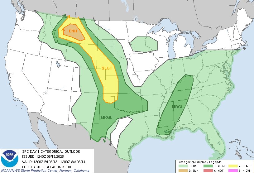
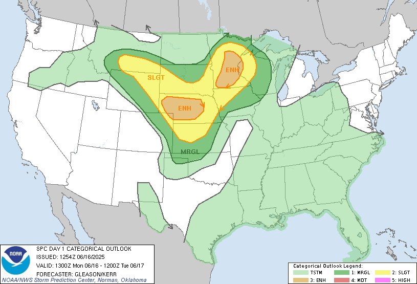
The Billings WFO forecast area was under a Slight (2/5) or higher convective risk from the Storm Prediction Center (SPC) for 4 consecutive days. Record high moisture values combined with high energy and wind shear created very favorable conditions for severe thunderstorms several days in a row. In just 4 days our office issued 96 Severe Thunderstorm Warnings, and 4 Tornado Warnings. Additionally, the SPC had most to all of the CWA under a Severe Thunderstorm Watch each day Friday through Sunday.
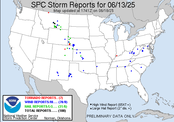
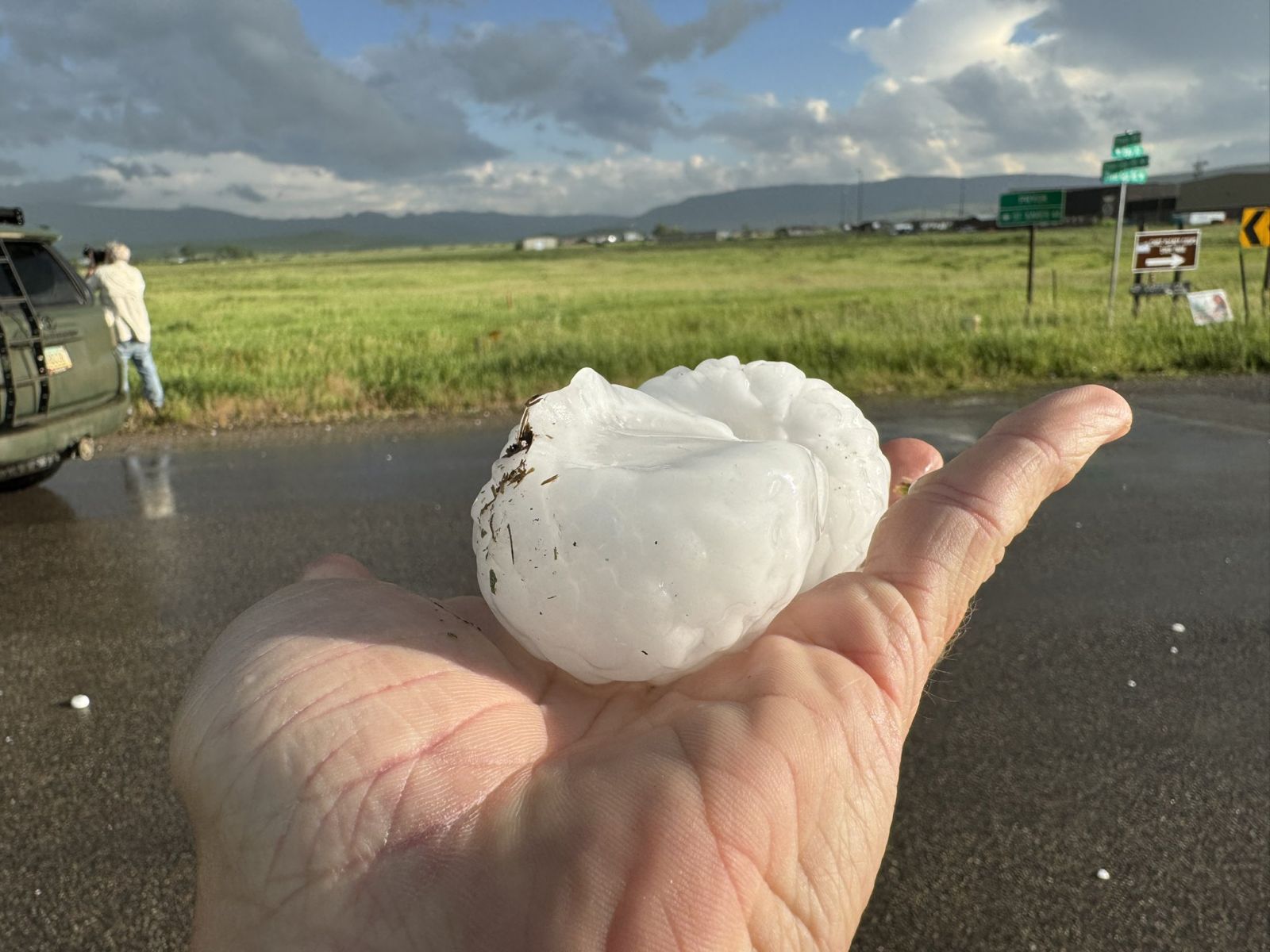
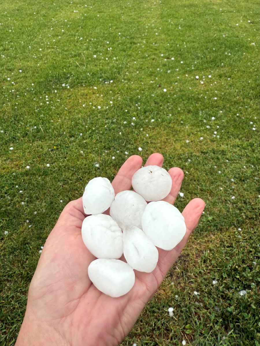
There were numerous reports of wind and hail damage across the region each day. Very large hail and strong winds reportedly caused widespread damage in Harlowton on Friday 13th. Later in the day, the largest hailstone of the weekend was reported in Pryor, MT at 2.75” (baseball sized). Sunday the 15th was a truly impressive day with severe storms sweeping through the entire region. A funnel cloud was reported near Roundup in the evening and an 81mph gust was recorded at the Miles City, MT ASOS a few hours later. On Monday a large storm produced a truly impressive hail swath with several inches of accumulating hail to the NE of Billings. As this storm moved into the Sheppard and Huntley area, the moderately sized hail was wind driven causing extensive damage to homes and businesses.
Overview
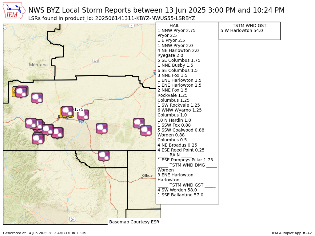
Hail up to baseball size was reported near Pryor, MT, and 2" hail occurred in Wheatland and Golden Valley Counties.
 |
 |
 |
|
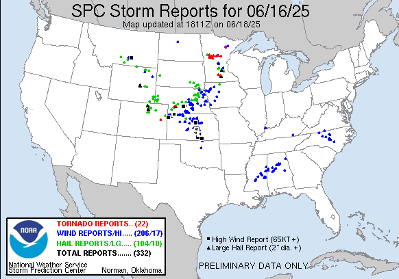
| SPC Convective Outlook | NWS Local Storm Reports | Upper Air Analysis - 500 mb |
Photos & Videos
 |
|||
| Large hail near Pryor, MT Courtesy of Mike Olbinski |
Radar
Radar loop given upon request.
Storm Reports
Preliminary Local Storm Report...Summary
National Weather Service Billings MT
711 AM MDT Sat Jun 14 2025

..TIME...   ...EVENT...      ...CITY LOCATION...     ...LAT.LON...
..DATE...   ....MAG....      ..COUNTY LOCATION..ST.. ...SOURCE....
            ..REMARKS..

1019 PM     Hail             6 WNW Wyarno            44.85N 106.87W
06/13/2025  M1.25 Inch       Sheridan           WY   Public


0610 PM     Tstm Wnd Gst     4 SW Worden             45.93N 108.23W
06/13/2025  E58 MPH          Yellowstone        MT   Mesonet


0615 PM     Hail             Worden                  45.97N 108.17W
06/13/2025  E0.88 Inch       Yellowstone        MT   Public

            Time estimated by radar.

0615 PM     Tstm Wnd Gst     1 SSE Ballantine        45.94N 108.15W
06/13/2025  M57 MPH          Yellowstone        MT   Mesonet

            Mesonet station MTBAL Ballantine I-94 Mp
            15.0.

0616 PM     Tstm Wnd Dmg     Worden                  45.97N 108.17W
06/13/2025                   Yellowstone        MT   Public

            Tree limbs down and small objects thrown
            around.

0821 PM     Rain             1 ESE Pompeys Pillar    45.99N 107.93W
06/13/2025  M1.75 Inch       Yellowstone        MT   Trained Spotter


0300 PM     Tstm Wnd Gst     5 W Harlowton           46.45N 109.94W
06/13/2025  M54 MPH          Wheatland          MT   Mesonet

            Mesonet station UMHM 5.1 W Harlowton
            (AGRIMET).

0305 PM     Tstm Wnd Dmg     3 ENE Harlowton         46.46N 109.78W
06/13/2025                   Wheatland          MT   Emergency Mngr

            EM report of multiple structures with lost
            roofs, uprooted trees as well as tree limb
            damage.

0305 PM     Hail             4 NE Harlowton          46.47N 109.77W
06/13/2025  M2.00 Inch       Wheatland          MT   Emergency Mngr


0310 PM     Tstm Wnd Dmg     Harlowton               46.44N 109.83W
06/13/2025                   Wheatland          MT   Public

            Corrects previous non-tstm wnd dmg report
            from Harlowton. Power lines down with some
            power outages reported.

0320 PM     Hail             1 ENE Harlowton         46.44N 109.82W
06/13/2025  E1.50 Inch       Wheatland          MT   Trained Spotter


0550 PM     Hail             4 ESE Reed Point        45.67N 109.47W
06/13/2025  E0.25 Inch       Stillwater         MT   Cocorahs


0605 PM     Hail             Columbus                45.64N 109.25W
06/13/2025  E0.50 Inch       Stillwater         MT   Public

            Report from mPING: Half-inch (0.50 in.).

0606 PM     Hail             Columbus                45.64N 109.25W
06/13/2025  E1.00 Inch       Stillwater         MT   Public


0615 PM     Hail             Columbus                45.64N 109.25W
06/13/2025  E1.25 Inch       Stillwater         MT   Public


0620 PM     Hail             5 SE Columbus           45.59N 109.19W
06/13/2025  E1.75 Inch       Stillwater         MT   Public

            Report from mPING: Golf Ball (1.75 in.).

0628 PM     Hail             6 SE Columbus           45.58N 109.17W
06/13/2025  M1.50 Inch       Stillwater         MT   Public


0926 PM     Hail             5 SSW Coalwood          45.67N 105.62W
06/13/2025  M0.88 Inch       Powder River       MT   Cocorahs


1024 PM     Hail             4 NE Broadus            45.49N 105.36W
06/13/2025  E0.25 Inch       Powder River       MT   Trained Spotter


0420 PM     Hail             Ryegate                 46.30N 109.25W
06/13/2025  E2.00 Inch       Golden Valley      MT   Public

            Time estimated by radar.

0640 PM     Hail             1 SW Rockvale           45.51N 108.88W
06/13/2025  M1.25 Inch       Carbon             MT   Public


0645 PM     Hail             2 NNE Fox               45.31N 109.20W
06/13/2025  E1.50 Inch       Carbon             MT   Public


0648 PM     Hail             3 NNE Fox               45.31N 109.20W
06/13/2025  E1.50 Inch       Carbon             MT   Public


0652 PM     Hail             Rockvale                45.52N 108.86W
06/13/2025  E1.25 Inch       Carbon             MT   Public

            Report from mPING: Half Dollar (1.25 in.).

0658 PM     Hail             1 SSW Fox               45.27N 109.23W
06/13/2025  M0.88 Inch       Carbon             MT   Public


0708 PM     Hail             Pryor                   45.42N 108.53W
06/13/2025  E2.50 Inch       Big Horn           MT   Public


0710 PM     Hail             1 NNW Pryor             45.43N 108.54W
06/13/2025  M2.75 Inch       Big Horn           MT   NWS Employee


0710 PM     Hail             10 N Hardin             45.88N 107.60W
06/13/2025  M1.00 Inch       Big Horn           MT   Trained Spotter


0711 PM     Hail             1 E Pryor               45.43N 108.51W
06/13/2025  E2.50 Inch       Big Horn           MT   Public

            Report from mPING: Tennis Ball (2.50 in.).

0715 PM     Hail             1 NNW Pryor             45.43N 108.54W
06/13/2025  E2.00 Inch       Big Horn           MT   NWS Employee


0800 PM     Hail             1 NNE Busby             45.54N 106.95W
06/13/2025  E1.50 Inch       Big Horn           MT   Trained Spotter


&&

$$
Overview
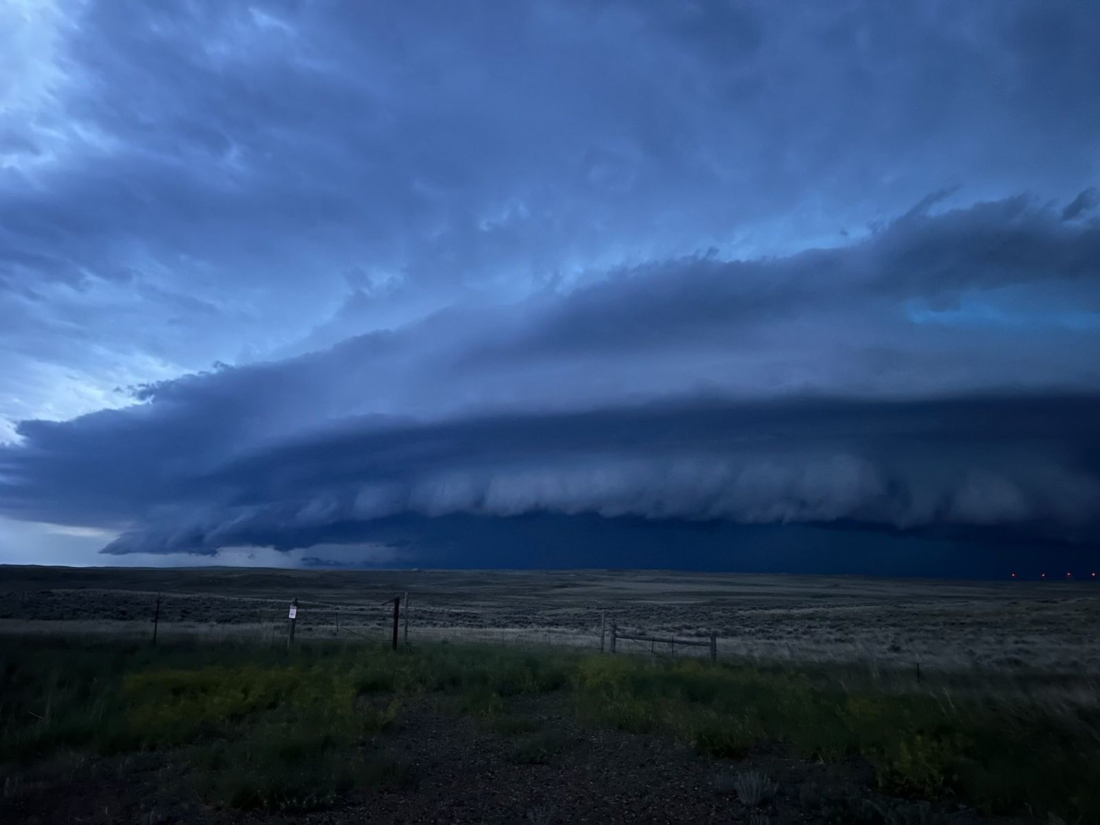
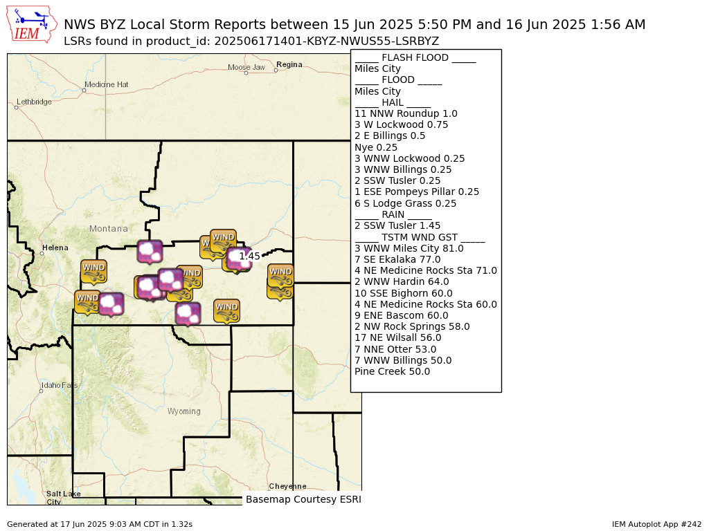
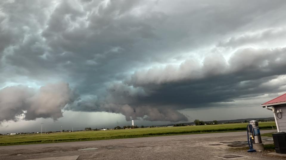
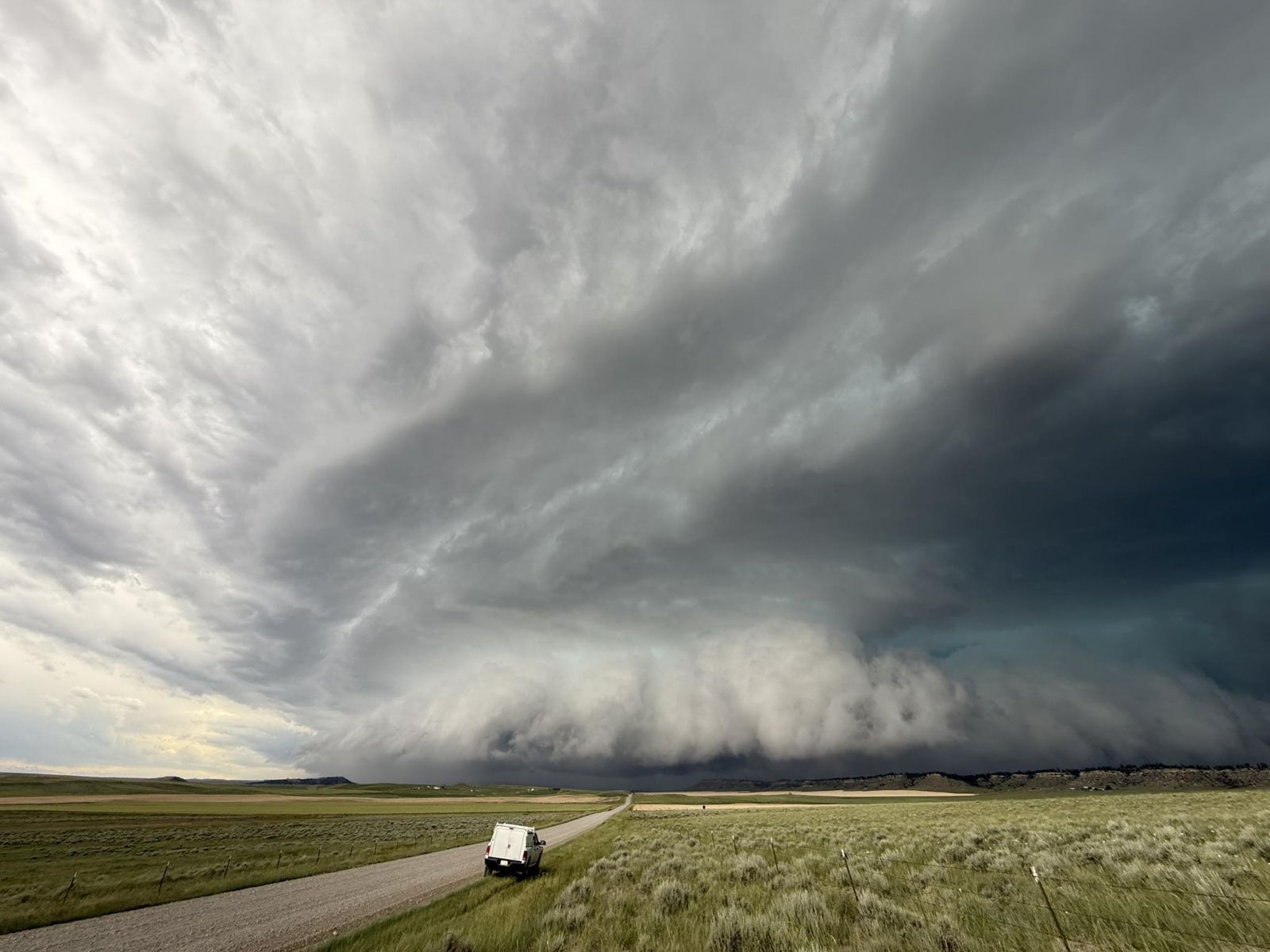
Miles City had a measured wind gust of 81 mph and localized flash flooding, causing a vehicle to be stranded in an underpass. The same storm produced a measured gust to 77 mph in northern Carter County. A funnel cloud was observed in northern Musselshell County.
 |
 |
 |
|
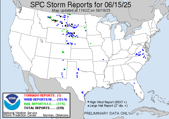
| SPC Convective Outlook |
NWS Local Storm Reports | Upper Air Analysis - 500 mb |
Photos & Videos
 |
 |
 |
|
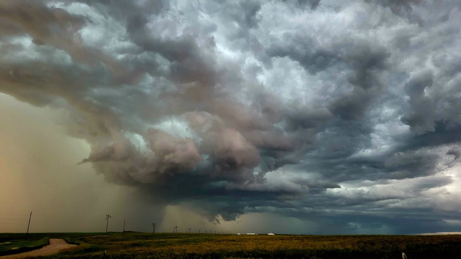
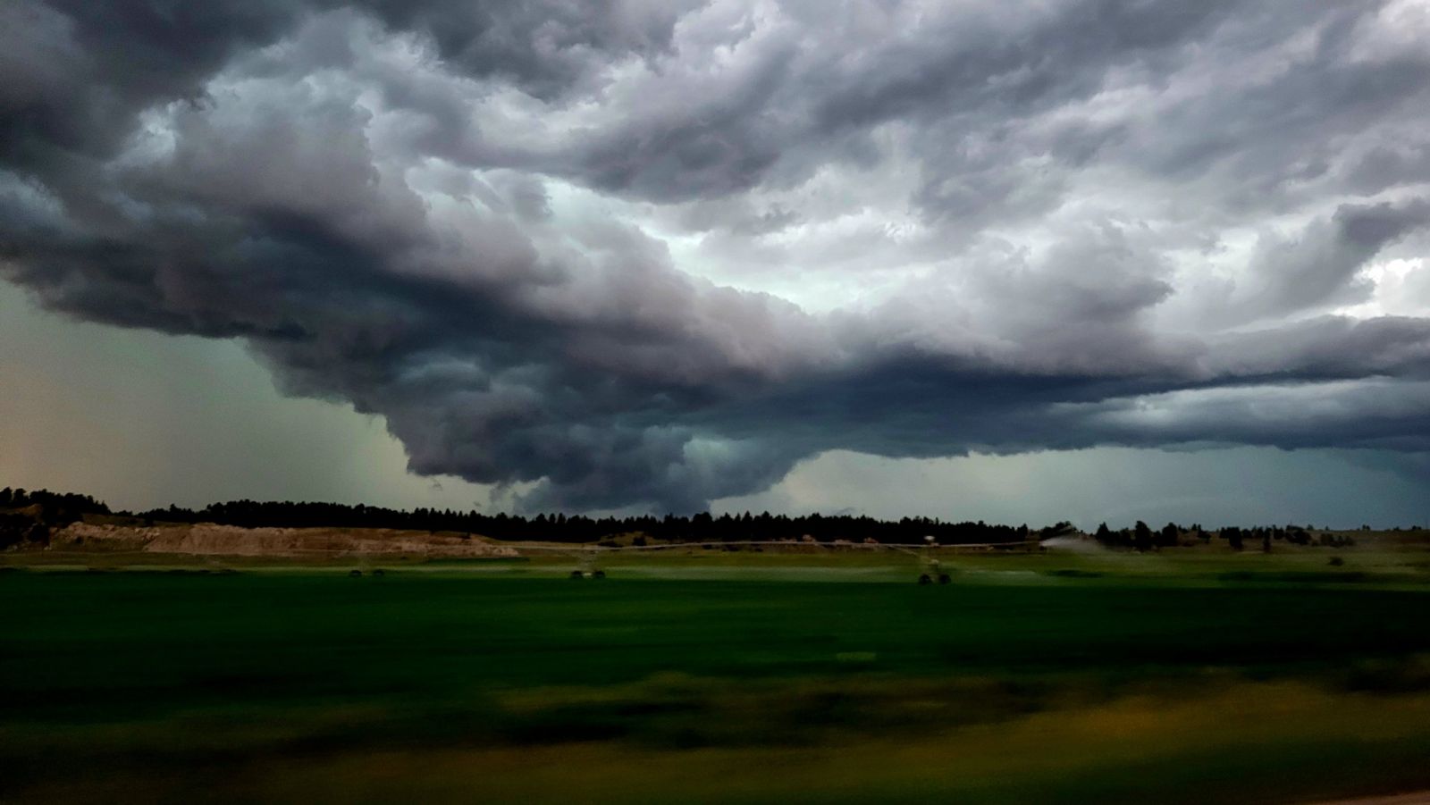
| Storm Structure near Broadview. Courtesy of John Ojeda |
Wall Cloud in Musselshell County. Courtesy of John Ojeda |
Approaching Storm towards Miles City. Courtesy of Angela |
Radar
 |
 |
||
| Radar Loop Reflectivity |
Radar Loop Velocity |
Storm Reports
Preliminary Local Storm Report...Summary
National Weather Service Billings MT
801 AM MDT Tue Jun 17 2025

..TIME...   ...EVENT...      ...CITY LOCATION...     ...LAT.LON...
..DATE...   ....MAG....      ..COUNTY LOCATION..ST.. ...SOURCE....
            ..REMARKS..

0820 PM     Tstm Wnd Gst     7 WNW Billings          45.82N 108.69W
06/15/2025  E50 MPH          Yellowstone        MT   NWS Employee


0835 PM     Hail             3 WNW Lockwood          45.83N 108.47W
06/15/2025  E0.25 Inch       Yellowstone        MT   Public


0835 PM     Hail             3 WNW Billings          45.81N 108.60W
06/15/2025  E0.25 Inch       Yellowstone        MT   Public


0835 PM     Hail             2 E Billings            45.79N 108.50W
06/15/2025  E0.50 Inch       Yellowstone        MT   Public


0841 PM     Hail             3 W Lockwood            45.84N 108.47W
06/15/2025  E0.75 Inch       Yellowstone        MT   Public

            Report from mPING: Dime (0.75 in.).

0913 PM     Hail             1 ESE Pompeys Pillar    45.99N 107.93W
06/15/2025  E0.25 Inch       Yellowstone        MT   Trained Spotter


0940 PM     Tstm Wnd Gst     10 SSE Bighorn          46.04N 107.34W
06/15/2025  E60 MPH          Treasure           MT   Trained Spotter


0716 PM     Hail             Nye                     45.45N 109.82W
06/15/2025  E0.25 Inch       Stillwater         MT   Public


0900 PM     Tstm Wnd Gst     9 ENE Bascom            46.70N 106.59W
06/15/2025  M60 MPH          Rosebud            MT   Mesonet

            Mesonet station MTM89 Angela W.

0950 PM     Tstm Wnd Gst     2 NW Rock Springs       46.83N 106.27W
06/15/2025  M58 MPH          Rosebud            MT   Dept of Highways


0927 PM     Tstm Wnd Gst     7 NNE Otter             45.30N 106.16W
06/15/2025  M53 MPH          Powder River       MT   Mesonet

            Mesonet station FHFM8 Fort Howes.

0550 PM     Tstm Wnd Gst     Pine Creek              45.50N 110.57W
06/15/2025  M50 MPH          Park               MT   Mesonet

            Mesonet station DW8455 Livingston.

0612 PM     Tstm Wnd Gst     17 NE Wilsall           46.16N 110.38W
06/15/2025  M56 MPH          Park               MT   Mesonet

            Mesonet station TT453 Crazy.

0720 PM     Hail             11 NNW Roundup          46.61N 108.59W
06/15/2025  E1.00 Inch       Musselshell        MT   Public


1215 AM     Tstm Wnd Gst     4 NE Medicine Rocks Sta 46.08N 104.44W
06/16/2025  M60 MPH          Fallon             MT   Mesonet

            Mesonet station MTEKA Baker Mt-7 Mp 14.2.

1230 AM     Tstm Wnd Gst     4 NE Medicine Rocks Sta 46.08N 104.44W
06/16/2025  M71 MPH          Fallon             MT   Dept of Highways


1012 PM     Tstm Wnd Gst     3 WNW Miles City        46.43N 105.89W
06/15/2025  M81 MPH          Custer             MT   ASOS


1026 PM     Flash Flood      Miles City              46.41N 105.84W
06/15/2025                   Custer             MT   Public

            Report from mPING: Street/road flooding;
            Street/road closed; Vehicles stranded.

1052 PM     Flood            Miles City              46.41N 105.84W
06/15/2025                   Custer             MT   Emergency Mngr

            Widespread street flooding across the city.
            Lots of standing water under overpasses; one
            vehicle submerged.

0100 AM     Hail             2 SSW Tusler            46.46N 105.77W
06/16/2025  M0.25 Inch       Custer             MT   Trained Spotter


0156 AM     Rain             2 SSW Tusler            46.46N 105.77W
06/16/2025  M1.45 Inch       Custer             MT   Trained Spotter


1254 AM     Tstm Wnd Gst     7 SE Ekalaka            45.81N 104.46W
06/16/2025  M77 MPH          Carter             MT   Mesonet


0750 PM     Hail             6 S Lodge Grass         45.23N 107.39W
06/15/2025  E0.25 Inch       Big Horn           MT   Trained Spotter


0935 PM     Tstm Wnd Gst     2 WNW Hardin            45.75N 107.66W
06/15/2025  M64 MPH          Big Horn           MT   AWOS

            AWOS station K00U 2 WNW Hardin.


&&

$$
Overview
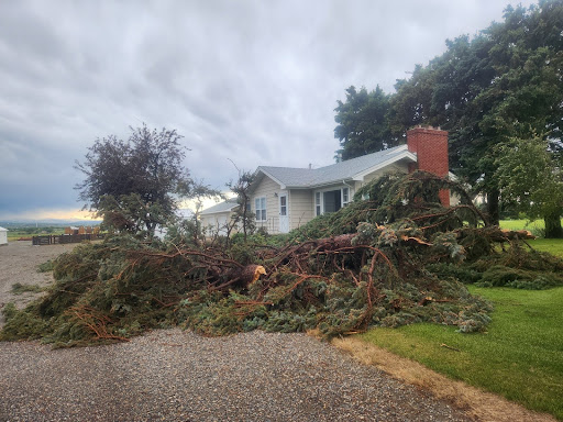
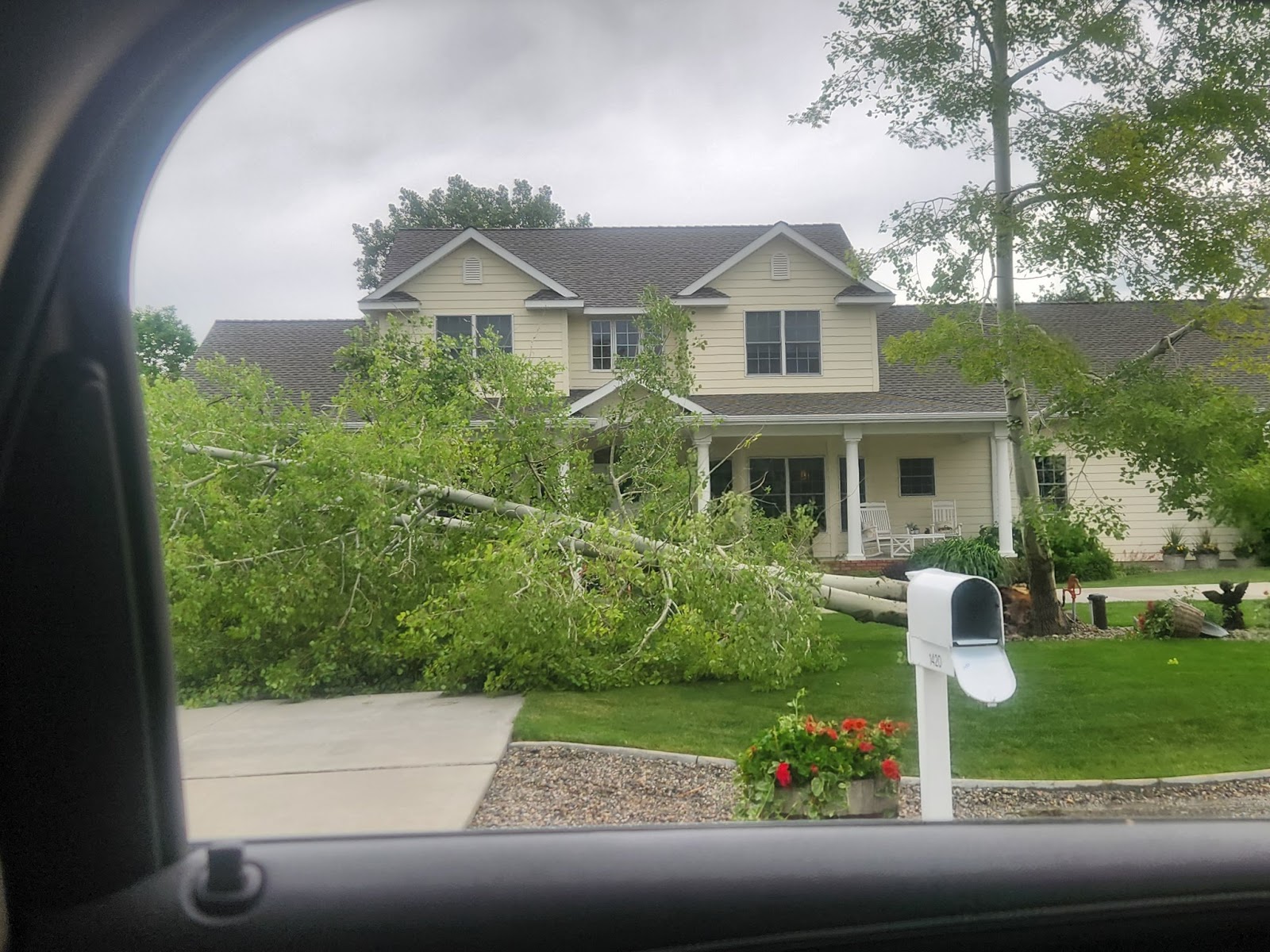
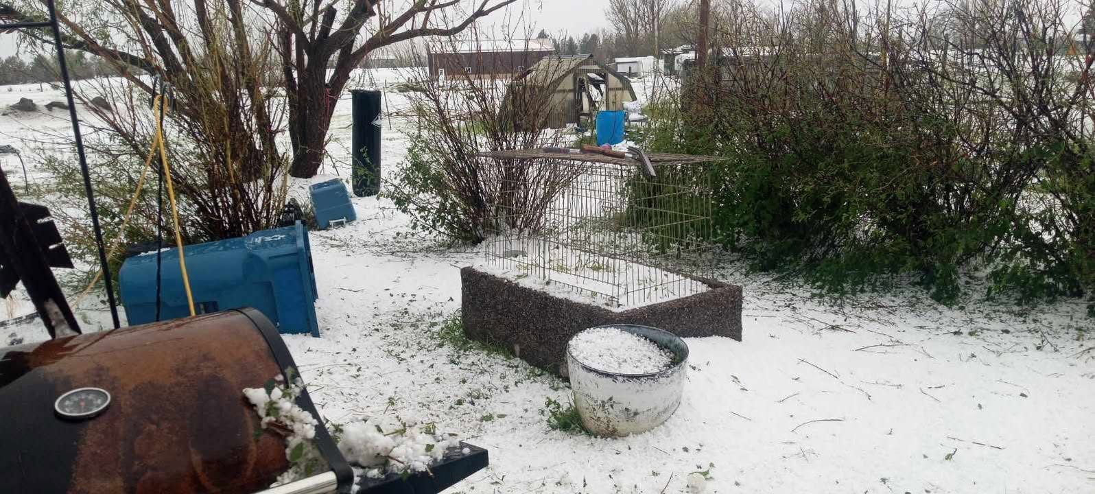
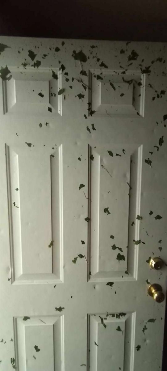
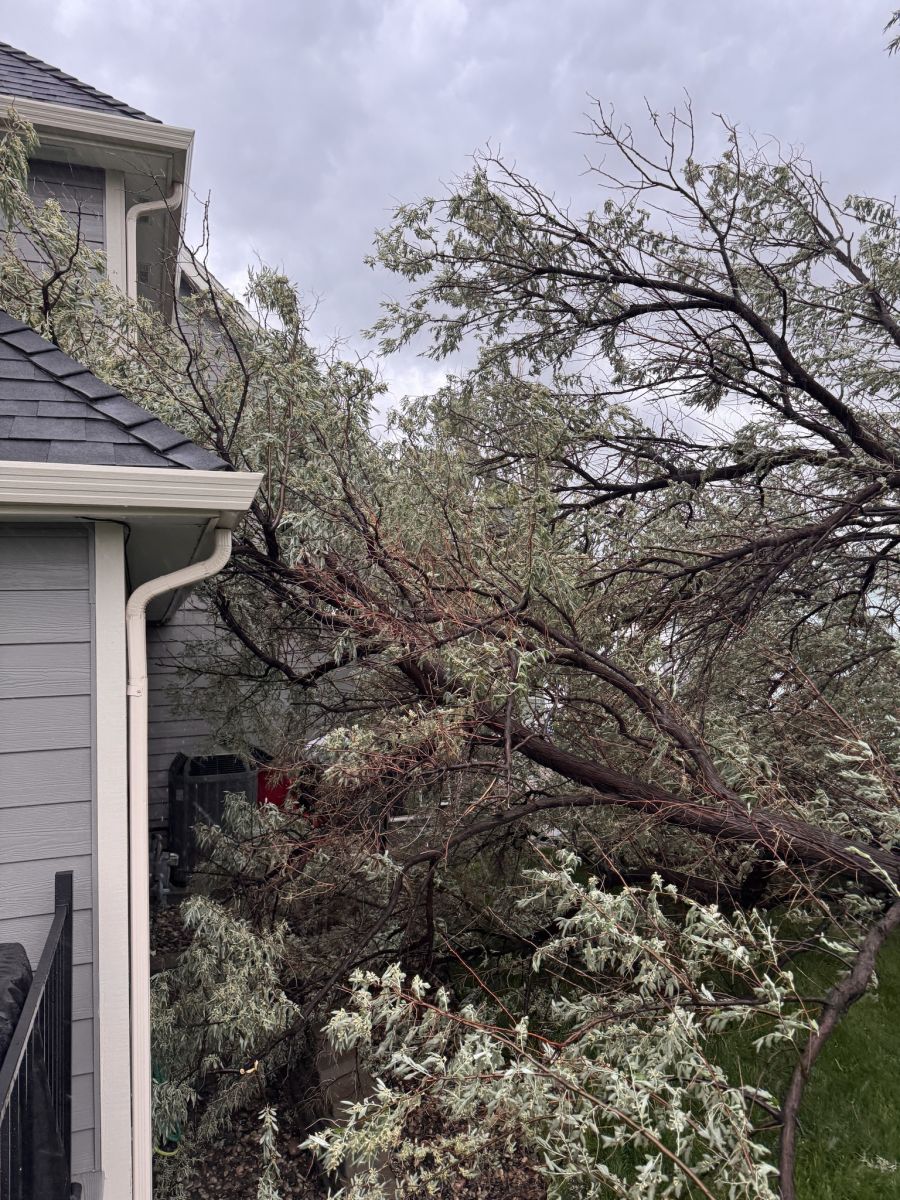
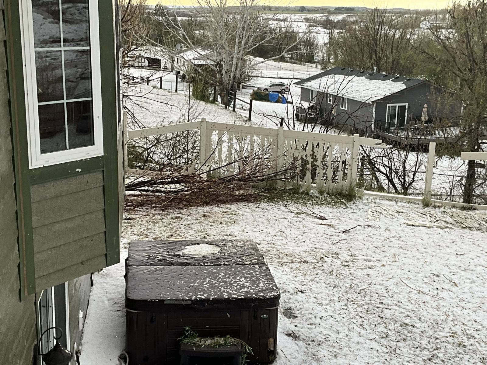
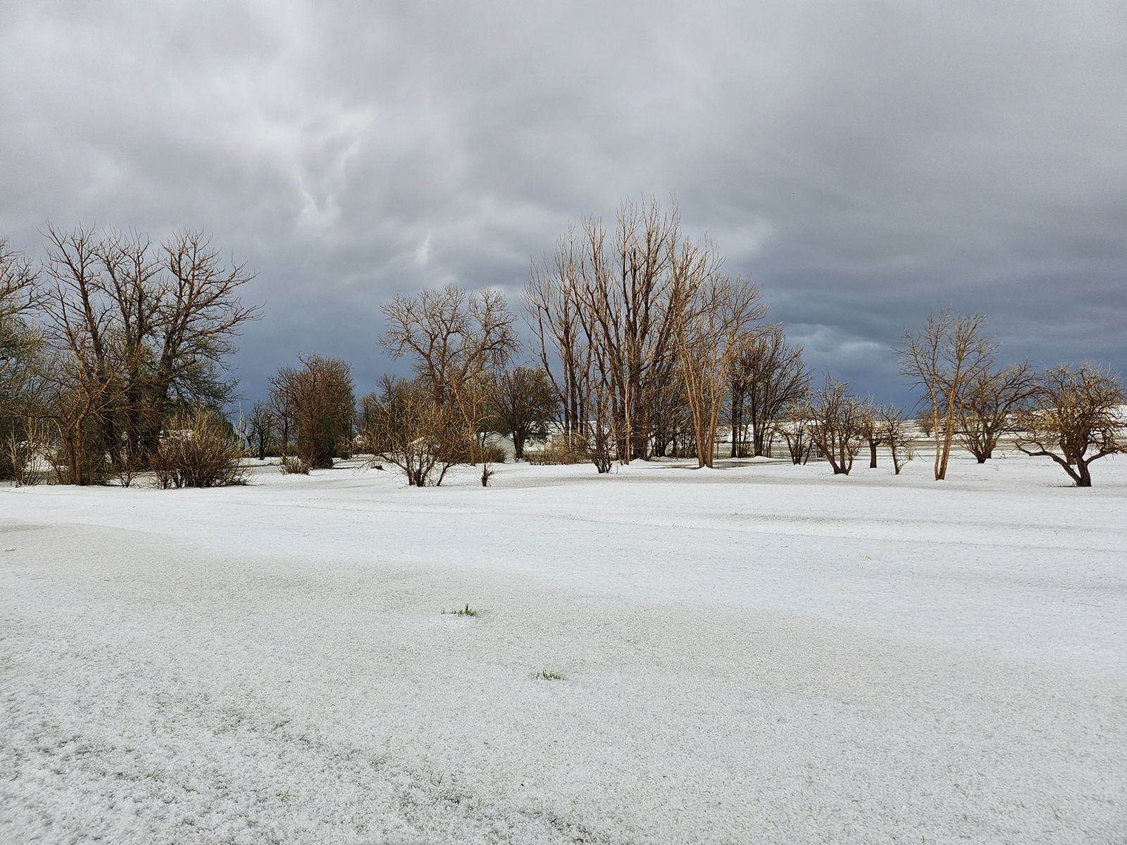
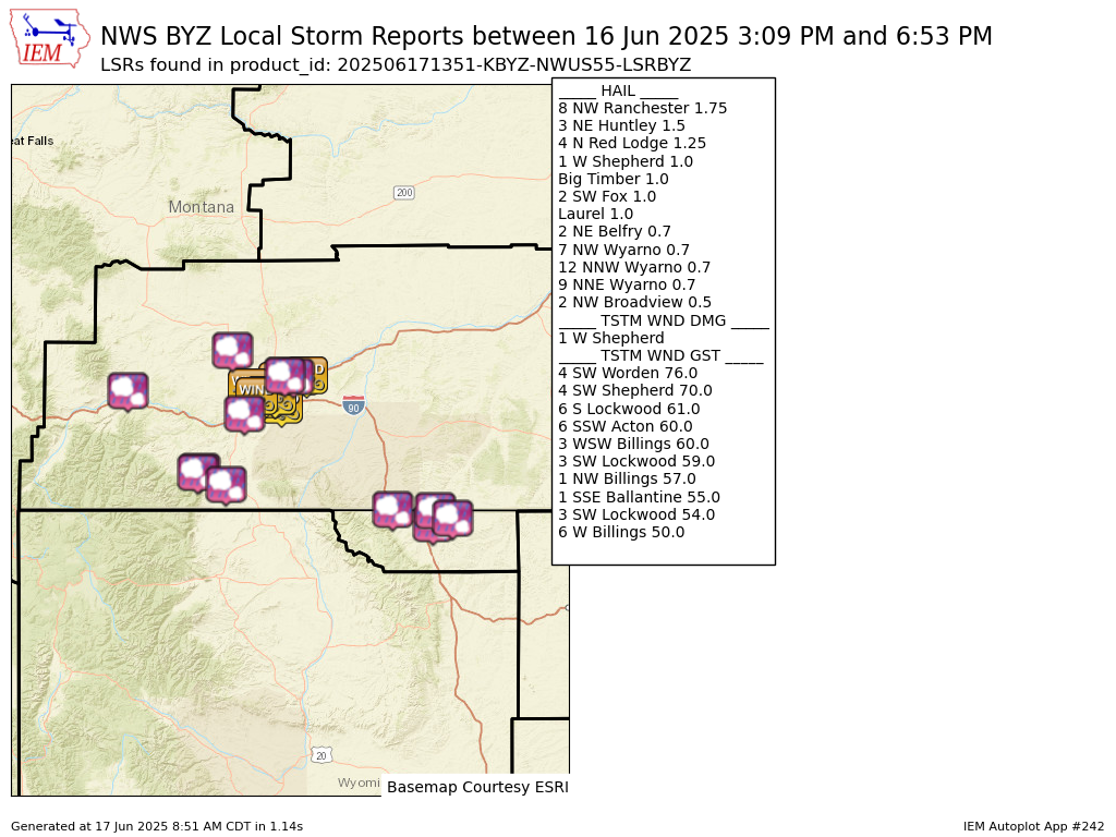
A storm moved through the Billings Heights, Shepherd, and Worden areas. A large amount of hail was produced by this storm, and a combination of hail up to 1.5" in diameter and measured 76 mph wind gusts stripped many roofs and sidings. So much hail occurred that it looked like it just snowed out, and the hail swatch could be seen from satellite imagery.
 |
 |
 |
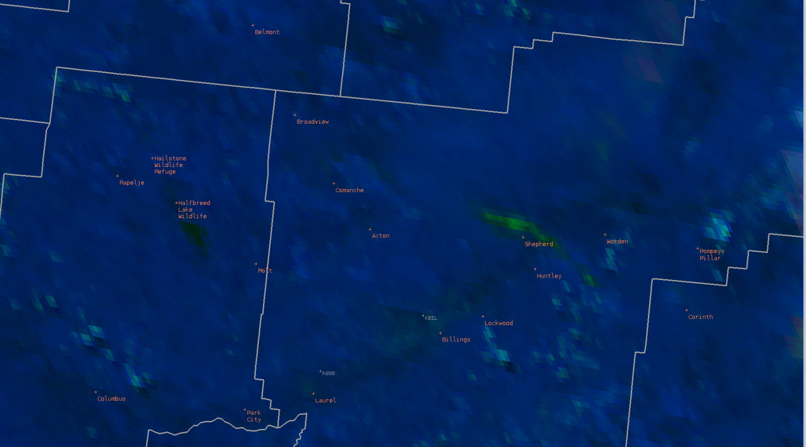 |
| SPC Convective Outlook | NWS Local Storm Reports | Upper Air Analysis - 500 mb | Satellite Imagery of Hail Swath (in green) |
Photos & Videos
 |
 |
 |
 |
| Downed Tree in Billings Heights Courtesy of Deven Olmstead |
Uprooted Tree in Billings Heights Courtesy of Deven Olmstead |
Hail in Shepherd Courtesy of Kassandra Dunnihoo |
Hail Pelted Door in Shepherd. Courtesy of Kassandra Dunnihoo |
 |
 |
 |
 |
| Uprooted Russian Olive Tree in the Billings Heights Courtesy of Emily Hedin |
Stripped Fencing in Shepherd. Courtesy of Barb Christison |
Storm Structure over Ballantine. Courtesy of MaKayla Sparrow |
Storm Structure north of Billings. Courtesy of Conquer the Storm |
 |
 |
||
| Hail on Ground at Ag Station near Huntley Courtesy of Lynn Meade |
Hail near Red Lodge Courtesy of Alanna Anderson |
Radar
 |
 |
||
| Radar Loop Reflectivity |
Radar Loop Velocity |
Storm Reports
Preliminary Local Storm Report...Summary
National Weather Service Billings MT
751 AM MDT Tue Jun 17 2025

..TIME...   ...EVENT...      ...CITY LOCATION...     ...LAT.LON...
..DATE...   ....MAG....      ..COUNTY LOCATION..ST.. ...SOURCE....
            ..REMARKS..

0600 PM     Hail             8 NW Ranchester         44.99N 107.28W
06/16/2025  M1.75 Inch       Sheridan           WY   Trained Spotter

            Estimated 60 mph wind gust.

0640 PM     Hail             7 NW Wyarno             44.89N 106.87W
06/16/2025  E0.70 Inch       Sheridan           WY   Cocorahs


0650 PM     Hail             12 NNW Wyarno           44.98N 106.85W
06/16/2025  E0.70 Inch       Sheridan           WY   Cocorahs


0653 PM     Hail             9 NNE Wyarno            44.93N 106.68W
06/16/2025  E0.70 Inch       Sheridan           WY   Cocorahs


0418 PM     Hail             2 NW Broadview          46.11N 108.90W
06/16/2025  E0.50 Inch       Yellowstone        MT   Trained Spotter

            Mainly pea size hail.

0441 PM     Tstm Wnd Gst     6 SSW Acton             45.85N 108.73W
06/16/2025  M60 MPH          Yellowstone        MT   Trained Spotter


0448 PM     Tstm Wnd Gst     6 W Billings            45.79N 108.65W
06/16/2025  E50 MPH          Yellowstone        MT   NWS Employee


0457 PM     Tstm Wnd Gst     1 NW Billings           45.80N 108.55W
06/16/2025  M57 MPH          Yellowstone        MT   ASOS

            ASOS station KBIL Billings.

0501 PM     Tstm Wnd Gst     3 SW Lockwood           45.79N 108.47W
06/16/2025  M54 MPH          Yellowstone        MT   Mesonet

            Mesonet station MTYRB 3.1 SW Lockwood (MT
            DOT).

0503 PM     Tstm Wnd Gst     3 WSW Billings          45.77N 108.60W
06/16/2025  E60 MPH          Yellowstone        MT   NWS Employee


0505 PM     Hail             Laurel                  45.67N 108.77W
06/16/2025  E1.00 Inch       Yellowstone        MT   Public


0506 PM     Tstm Wnd Gst     4 SW Shepherd           45.90N 108.42W
06/16/2025  E70 MPH          Yellowstone        MT   Public

            Estimated 60-70 mph. Very large tree
            branches down.

0510 PM     Tstm Wnd Gst     4 SW Worden             45.93N 108.23W
06/16/2025  M76 MPH          Yellowstone        MT   Mesonet

            Mesonet station Huntley E.

0516 PM     Tstm Wnd Gst     3 SW Lockwood           45.79N 108.47W
06/16/2025  M59 MPH          Yellowstone        MT   Mesonet

            Mesonet station MTYRB 3.1 SW Lockwood (MT
            DOT).

0521 PM     Tstm Wnd Gst     6 S Lockwood            45.73N 108.40W
06/16/2025  M61 MPH          Yellowstone        MT   Mesonet

            Mesonet station SDAM8 Soda Springs.

0525 PM     Tstm Wnd Dmg     1 W Shepherd            45.94N 108.37W
06/16/2025                   Yellowstone        MT   Trained Spotter

            Extensive tree damage. Several roof tops in
            area damaged or ripped up.

0525 PM     Hail             1 W Shepherd            45.94N 108.37W
06/16/2025  E1.00 Inch       Yellowstone        MT   Trained Spotter

            Pea to quarter size hail accumulating up to
            8 inches.

0526 PM     Hail             3 NE Huntley            45.93N 108.28W
06/16/2025  E1.50 Inch       Yellowstone        MT   Public


0530 PM     Tstm Wnd Gst     1 SSE Ballantine        45.94N 108.15W
06/16/2025  M55 MPH          Yellowstone        MT   Mesonet

            Mesonet station MTBAL Ballantine I-94 Mp
            15.0.

0344 PM     Hail             Big Timber              45.83N 109.95W
06/16/2025  E1.00 Inch       Sweet Grass        MT   Public


0309 PM     Hail             2 SW Fox                45.25N 109.25W
06/16/2025  M1.00 Inch       Carbon             MT   Trained Spotter

            Mostly pea to half inch hail with a few
            quarter size hailstones mixed in.

0313 PM     Hail             4 N Red Lodge           45.26N 109.23W
06/16/2025  E1.25 Inch       Carbon             MT   Public


0450 PM     Hail             2 NE Belfry             45.17N 108.96W
06/16/2025  M0.70 Inch       Carbon             MT   Trained Spotter


&&

$$
 |
Media use of NWS Web News Stories is encouraged! Please acknowledge the NWS as the source of any news information accessed from this site. |
|

