A heat wave over the Southwest will intensify late week, peaking and expanding into the Intermountain West and northern High Plains this weekend. Severe thunderstorms and heavy rain are expected over portions of the Plains and Mississippi Valley tonight, which will shift to parts of the Upper Midwest and mid-Mississippi Valley Friday. Monsoonal showers and flooding persist in the Desert Southwest. Read More >
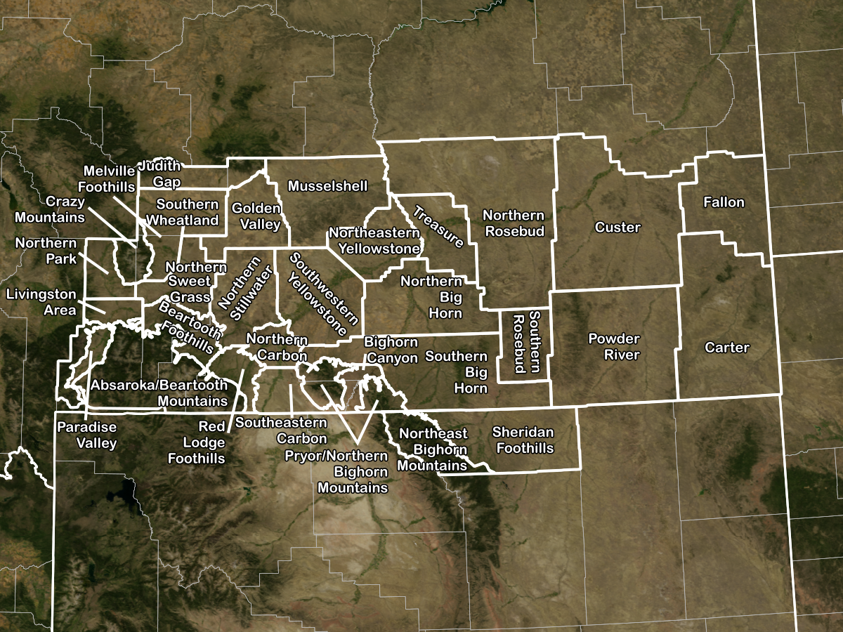
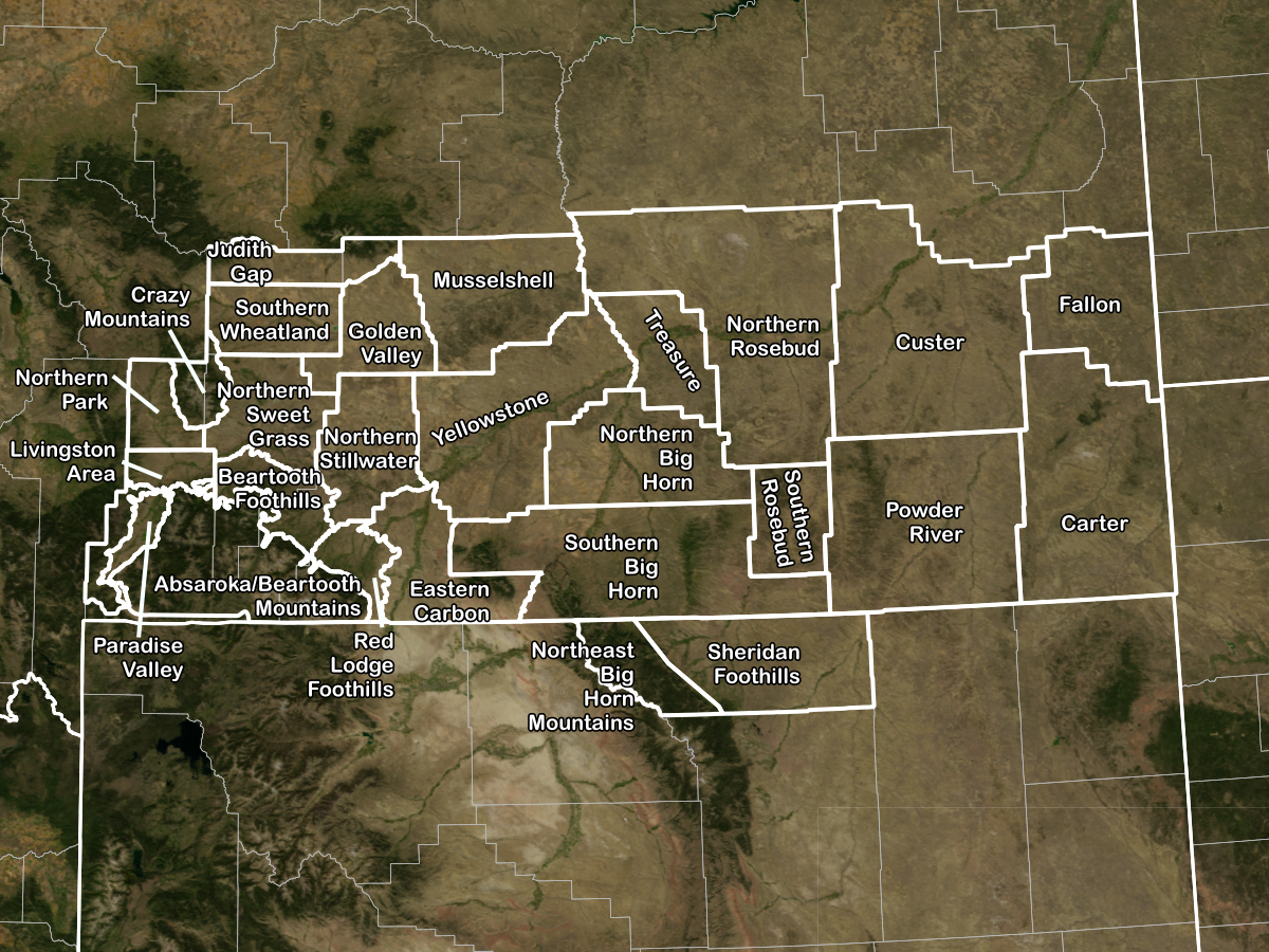
Effective Tuseday, October 15, 2019, at 1200 PM Mountain Daylight Time, 1800 Coordinated Universal Time (UTC), the NWS WFO in Billings, Montana (WFO BYZ) will change all public forecast zone names and boundaries. Upon implementation of this change, all public forecasts and related products will use the zone numbers and names shown below.
The zone changes will improve services by allowing more fine-tuned warnings and advisories for hazards such as dust, fog, and winter weather.
In Montana, most long-fused watches, warnings, and advisories issued by the NWS (such as Wind Advisories and Winter Storm Warnings) are issued in areas called “zones”. Our current configuration of 26 forecast zones was created during the mid-1990s using broad-brushed climate areas and has not significantly changed since that time. Over the years, NWS Billings meteorologists have found that our current zone configuration does not adequately reflect important local differences in geography and weather impacts. This sometimes results in "over-warning", where an impact is occurring within the current structure of our zones.
To provide a better service to our community we are working towards changing our zone configuration from 26 zones to 31 zones. These proposed zone changes are based on both climatological data, such as average annual precipitation; known weather, water, and climate impacts; and forecaster experience.
There are numerous examples of how adopting a new forecast zone configuration would be valuable for both our core partners, and the public:
Example 1: The Bighorn Canyon is a popular site for recreationists, and is prone to experience strong winds that funnel through the canyon and exit at Fort Smith, MT. These winds are unique to this specific location and do not occur throughout the remainder of southern Big Horn county, a zone that currently includes the town of Crow Agency and much of the Crow Reservation. A new zone at Bighorn Canyon will allow us to fine tune our services for hazardous winds in this area.
Example 2: East of the Crazy Mountains, and between the Musselshell River to the north and Yellowstone River to the south, exists an area of higher elevations that sees much more snowfall than the surrounding valleys. Highway 191 passes through this region, which includes the town of Melville, and can be impacted by significant snowfall. A new zone at the Melville Foothills will enable us to issue winter highlights for this specific area, without the mention of the Harlowton and Big Timber, two towns that lie in the lower river valleys and typically receive much less snowfall.
Current Zones |
|
|---|---|
| Zone # | Zone Name |
| MT067 | Absaroka/Beartooth Mountains |
| MT066 | Beartooth Foothills |
| MT068 | Crazy Mountains |
| MT032 | Custer |
| MT033 | Fallon |
| MT029 | Musselshell |
| MT036 | Powder River |
| MT030 | Treasure |
| MT035 | Yellowstone |
| MT041 | Northern Sweet Grass |
| MT034 | Northern Stillwater |
| MT064 | Paradise Valley |
| MT065 | Livingston Area |
| MT040 | Northern Park |
| MT042 | Golden Valley |
| MT028 | Southern Wheatland |
| MT039 | Eastern Carbon |
| MT056 | Red Lodge Foothills |
| MT057 | Northern Big Horn |
| MT038 | Southern Big Horn |
| MT031 | Northern Rosebud |
| MT058 | Southern Rosebud |
| WY099 | Sheridan Foothills |
| WY098 | Northeast Big Horn Mountains |
| MT063 | Judith Gap |
| MT037 | Carter |
Proposed New Zones |
|
|---|---|
| New Zone # | New Zone Name |
| MT067 | Absaroka/Beartooth Mountains |
| MT066 | Beartooth Foothills |
| MT169 | Bighorn Canyon |
| MT037 | Carter |
| MT068 | Crazy Mountains |
| MT032 | Custer |
| MT033 | Fallon |
| MT042 | Golden Valley |
| MT063 | Judith Gap |
| MT065 | Livingston Area |
| MT172 | Melville Foothills |
| MT029 | Musselshell |
| WY198 | Northeast Bighorn Mountains |
| MT173 | Northeastern Yellowstone |
| MT057 | Northern Big Horn |
| MT170 | Northern Carbon |
| MT040 | Northern Park |
| MT031 | Northern Rosebud |
| MT034 | Northern Stillwater |
| MT141 | Northern Sweet Grass |
| MT064 | Paradise Valley |
| MT036 | Powder River |
| MT171 | Pryor/Northern Bighorn Mountains |
| MT056 | Red Lodge Foothills |
| WY199 | Sheridan Foothills |
| MT139 | Southeastern Carbon |
| MT138 | Southern Big Horn |
| MT058 | Southern Rosebud |
| MT228 | Southern Wheatland |
| MT235 | Southwestern Yellowstone |
| MT030 | Treasure |
Updated public zone shapefiles are available for download via the NWS GIS Portal.
For more information or for comments, please contact us via e-mail or 406-652-0851