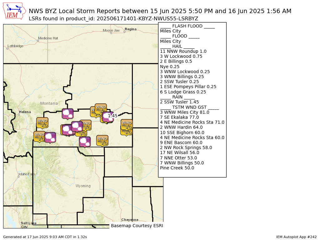
Preliminary Local Storm Report...Summary
National Weather Service Billings MT
801 AM MDT Tue Jun 17 2025

..TIME...   ...EVENT...      ...CITY LOCATION...     ...LAT.LON...
..DATE...   ....MAG....      ..COUNTY LOCATION..ST.. ...SOURCE....
            ..REMARKS..

0820 PM     Tstm Wnd Gst     7 WNW Billings          45.82N 108.69W
06/15/2025  E50 MPH          Yellowstone        MT   NWS Employee


0835 PM     Hail             3 WNW Lockwood          45.83N 108.47W
06/15/2025  E0.25 Inch       Yellowstone        MT   Public


0835 PM     Hail             3 WNW Billings          45.81N 108.60W
06/15/2025  E0.25 Inch       Yellowstone        MT   Public


0835 PM     Hail             2 E Billings            45.79N 108.50W
06/15/2025  E0.50 Inch       Yellowstone        MT   Public


0841 PM     Hail             3 W Lockwood            45.84N 108.47W
06/15/2025  E0.75 Inch       Yellowstone        MT   Public

            Report from mPING: Dime (0.75 in.).

0913 PM     Hail             1 ESE Pompeys Pillar    45.99N 107.93W
06/15/2025  E0.25 Inch       Yellowstone        MT   Trained Spotter


0940 PM     Tstm Wnd Gst     10 SSE Bighorn          46.04N 107.34W
06/15/2025  E60 MPH          Treasure           MT   Trained Spotter


0716 PM     Hail             Nye                     45.45N 109.82W
06/15/2025  E0.25 Inch       Stillwater         MT   Public


0900 PM     Tstm Wnd Gst     9 ENE Bascom            46.70N 106.59W
06/15/2025  M60 MPH          Rosebud            MT   Mesonet

            Mesonet station MTM89 Angela W.

0950 PM     Tstm Wnd Gst     2 NW Rock Springs       46.83N 106.27W
06/15/2025  M58 MPH          Rosebud            MT   Dept of Highways


0927 PM     Tstm Wnd Gst     7 NNE Otter             45.30N 106.16W
06/15/2025  M53 MPH          Powder River       MT   Mesonet

            Mesonet station FHFM8 Fort Howes.

0550 PM     Tstm Wnd Gst     Pine Creek              45.50N 110.57W
06/15/2025  M50 MPH          Park               MT   Mesonet

            Mesonet station DW8455 Livingston.

0612 PM     Tstm Wnd Gst     17 NE Wilsall           46.16N 110.38W
06/15/2025  M56 MPH          Park               MT   Mesonet

            Mesonet station TT453 Crazy.

0720 PM     Hail             11 NNW Roundup          46.61N 108.59W
06/15/2025  E1.00 Inch       Musselshell        MT   Public


1215 AM     Tstm Wnd Gst     4 NE Medicine Rocks Sta 46.08N 104.44W
06/16/2025  M60 MPH          Fallon             MT   Mesonet

            Mesonet station MTEKA Baker Mt-7 Mp 14.2.

1230 AM     Tstm Wnd Gst     4 NE Medicine Rocks Sta 46.08N 104.44W
06/16/2025  M71 MPH          Fallon             MT   Dept of Highways


1012 PM     Tstm Wnd Gst     3 WNW Miles City        46.43N 105.89W
06/15/2025  M81 MPH          Custer             MT   ASOS


1026 PM     Flash Flood      Miles City              46.41N 105.84W
06/15/2025                   Custer             MT   Public

            Report from mPING: Street/road flooding;
            Street/road closed; Vehicles stranded.

1052 PM     Flood            Miles City              46.41N 105.84W
06/15/2025                   Custer             MT   Emergency Mngr

            Widespread street flooding across the city.
            Lots of standing water under overpasses; one
            vehicle submerged.

0100 AM     Hail             2 SSW Tusler            46.46N 105.77W
06/16/2025  M0.25 Inch       Custer             MT   Trained Spotter


0156 AM     Rain             2 SSW Tusler            46.46N 105.77W
06/16/2025  M1.45 Inch       Custer             MT   Trained Spotter


1254 AM     Tstm Wnd Gst     7 SE Ekalaka            45.81N 104.46W
06/16/2025  M77 MPH          Carter             MT   Mesonet


0750 PM     Hail             6 S Lodge Grass         45.23N 107.39W
06/15/2025  E0.25 Inch       Big Horn           MT   Trained Spotter


0935 PM     Tstm Wnd Gst     2 WNW Hardin            45.75N 107.66W
06/15/2025  M64 MPH          Big Horn           MT   AWOS

            AWOS station K00U 2 WNW Hardin.


&&

$$