Widespread showers and thunderstorms, some severe, may produce heavy downpours and flash flooding across much of the eastern and central U.S. Dangerous heat will continue in the Pacific Northwest and expand across portions of the East. Deep tropical moisture and associated thunderstorms will bring heavy rainfall and localized flash flooding across portions of Florida into the central Gulf Coast. Read More >
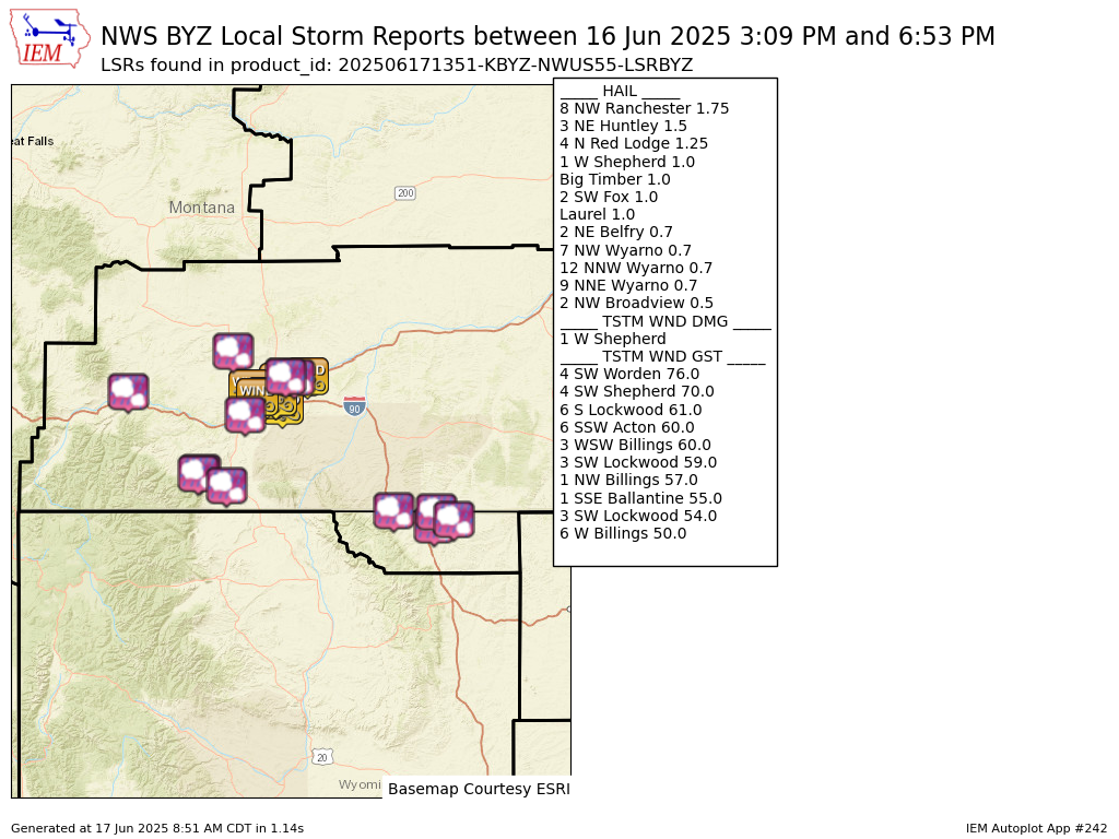
Preliminary Local Storm Report...Summary
National Weather Service Billings MT
751 AM MDT Tue Jun 17 2025

..TIME...   ...EVENT...      ...CITY LOCATION...     ...LAT.LON...
..DATE...   ....MAG....      ..COUNTY LOCATION..ST.. ...SOURCE....
            ..REMARKS..

0600 PM     Hail             8 NW Ranchester         44.99N 107.28W
06/16/2025  M1.75 Inch       Sheridan           WY   Trained Spotter

            Estimated 60 mph wind gust.

0640 PM     Hail             7 NW Wyarno             44.89N 106.87W
06/16/2025  E0.70 Inch       Sheridan           WY   Cocorahs


0650 PM     Hail             12 NNW Wyarno           44.98N 106.85W
06/16/2025  E0.70 Inch       Sheridan           WY   Cocorahs


0653 PM     Hail             9 NNE Wyarno            44.93N 106.68W
06/16/2025  E0.70 Inch       Sheridan           WY   Cocorahs


0418 PM     Hail             2 NW Broadview          46.11N 108.90W
06/16/2025  E0.50 Inch       Yellowstone        MT   Trained Spotter

            Mainly pea size hail.

0441 PM     Tstm Wnd Gst     6 SSW Acton             45.85N 108.73W
06/16/2025  M60 MPH          Yellowstone        MT   Trained Spotter


0448 PM     Tstm Wnd Gst     6 W Billings            45.79N 108.65W
06/16/2025  E50 MPH          Yellowstone        MT   NWS Employee


0457 PM     Tstm Wnd Gst     1 NW Billings           45.80N 108.55W
06/16/2025  M57 MPH          Yellowstone        MT   ASOS

            ASOS station KBIL Billings.

0501 PM     Tstm Wnd Gst     3 SW Lockwood           45.79N 108.47W
06/16/2025  M54 MPH          Yellowstone        MT   Mesonet

            Mesonet station MTYRB 3.1 SW Lockwood (MT
            DOT).

0503 PM     Tstm Wnd Gst     3 WSW Billings          45.77N 108.60W
06/16/2025  E60 MPH          Yellowstone        MT   NWS Employee


0505 PM     Hail             Laurel                  45.67N 108.77W
06/16/2025  E1.00 Inch       Yellowstone        MT   Public


0506 PM     Tstm Wnd Gst     4 SW Shepherd           45.90N 108.42W
06/16/2025  E70 MPH          Yellowstone        MT   Public

            Estimated 60-70 mph. Very large tree
            branches down.

0510 PM     Tstm Wnd Gst     4 SW Worden             45.93N 108.23W
06/16/2025  M76 MPH          Yellowstone        MT   Mesonet

            Mesonet station Huntley E.

0516 PM     Tstm Wnd Gst     3 SW Lockwood           45.79N 108.47W
06/16/2025  M59 MPH          Yellowstone        MT   Mesonet

            Mesonet station MTYRB 3.1 SW Lockwood (MT
            DOT).

0521 PM     Tstm Wnd Gst     6 S Lockwood            45.73N 108.40W
06/16/2025  M61 MPH          Yellowstone        MT   Mesonet

            Mesonet station SDAM8 Soda Springs.

0525 PM     Tstm Wnd Dmg     1 W Shepherd            45.94N 108.37W
06/16/2025                   Yellowstone        MT   Trained Spotter

            Extensive tree damage. Several roof tops in
            area damaged or ripped up.

0525 PM     Hail             1 W Shepherd            45.94N 108.37W
06/16/2025  E1.00 Inch       Yellowstone        MT   Trained Spotter

            Pea to quarter size hail accumulating up to
            8 inches.

0526 PM     Hail             3 NE Huntley            45.93N 108.28W
06/16/2025  E1.50 Inch       Yellowstone        MT   Public


0530 PM     Tstm Wnd Gst     1 SSE Ballantine        45.94N 108.15W
06/16/2025  M55 MPH          Yellowstone        MT   Mesonet

            Mesonet station MTBAL Ballantine I-94 Mp
            15.0.

0344 PM     Hail             Big Timber              45.83N 109.95W
06/16/2025  E1.00 Inch       Sweet Grass        MT   Public


0309 PM     Hail             2 SW Fox                45.25N 109.25W
06/16/2025  M1.00 Inch       Carbon             MT   Trained Spotter

            Mostly pea to half inch hail with a few
            quarter size hailstones mixed in.

0313 PM     Hail             4 N Red Lodge           45.26N 109.23W
06/16/2025  E1.25 Inch       Carbon             MT   Public


0450 PM     Hail             2 NE Belfry             45.17N 108.96W
06/16/2025  M0.70 Inch       Carbon             MT   Trained Spotter


&&

$$