
Numerous severe thunderstorms are expected across a broad region from the Ohio Valley to the Mid-Atlantic and Northeast States today into tonight. Swaths of damaging wind gusts are expected and some tornadoes are possible. Bertha is expected to bring tropical storm conditions to portions of the Gulf Coast from the Florida Panhandle westward to southeastern Louisiana later today and Wednesday. Read More >
Columbia, SC
Weather Forecast Office
...Tornadoes Confirmed Across Central SC and East Central GA...
...Map with Warnings Issued and Preliminary Local Storm Reports...
...Damage Pictures from Across the County Warning Area...
...Visible Satellite Imagery loop of the Event...
...Radar Imagery of the event...
A Case Study of the 15 March 2008 South Carolina Supercell Outbreak (pdf)
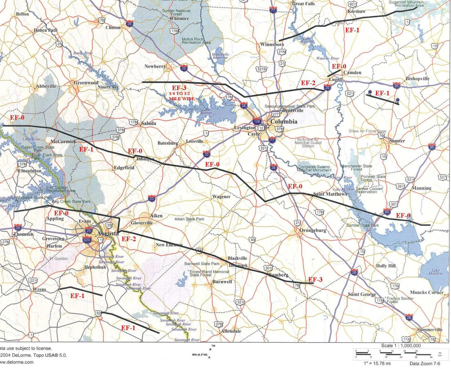
Preliminary Tornado Tracks
NWS Survey Teams have completed their Storm Surveys and these are preliminary findings as it relates to the Enhanced Fujita scale for damage. (Click map for larger image)
Hazards
South Carolina
Georgia
National Warnings
Tropical Weather
Weather Briefing
Provide Storm Reports
Email Alerts
Enhanced Hazardous Weather Outlook
GIS
KML/KMZ Data
Shapefile Data
Current Conditions
Observations
Satellite Images
Five Points
River and Lake Levels
River and Lake NWPS
Coop Reports
Lake Observations
Met Calculator
Mesonet Data
Radar
Nationwide
Charlotte TDWR
Columbia Radar
Forecasts
Winter
Activity Planner
Graphic Forecasts
Text Products
Aviation
Marine
Fire Weather
Air Quality
Forecast Discussion
RSS/XML
Experimental FRET
Hydrology
SC Streamflow
GA Streamflow
Drought Info
River and Lakes NWPS
Climate
Climate Plots
National
Local Climo
CoCoRaHs
Weather History Calendar
SERCC
NCEI
US Dept of Commerce
National Oceanic and Atmospheric Administration
National Weather Service
Columbia, SC
2909 Aviation Way
West Columbia, SC 29170-2102
(803) 822-8135
Comments? Questions? Please Contact Us.

