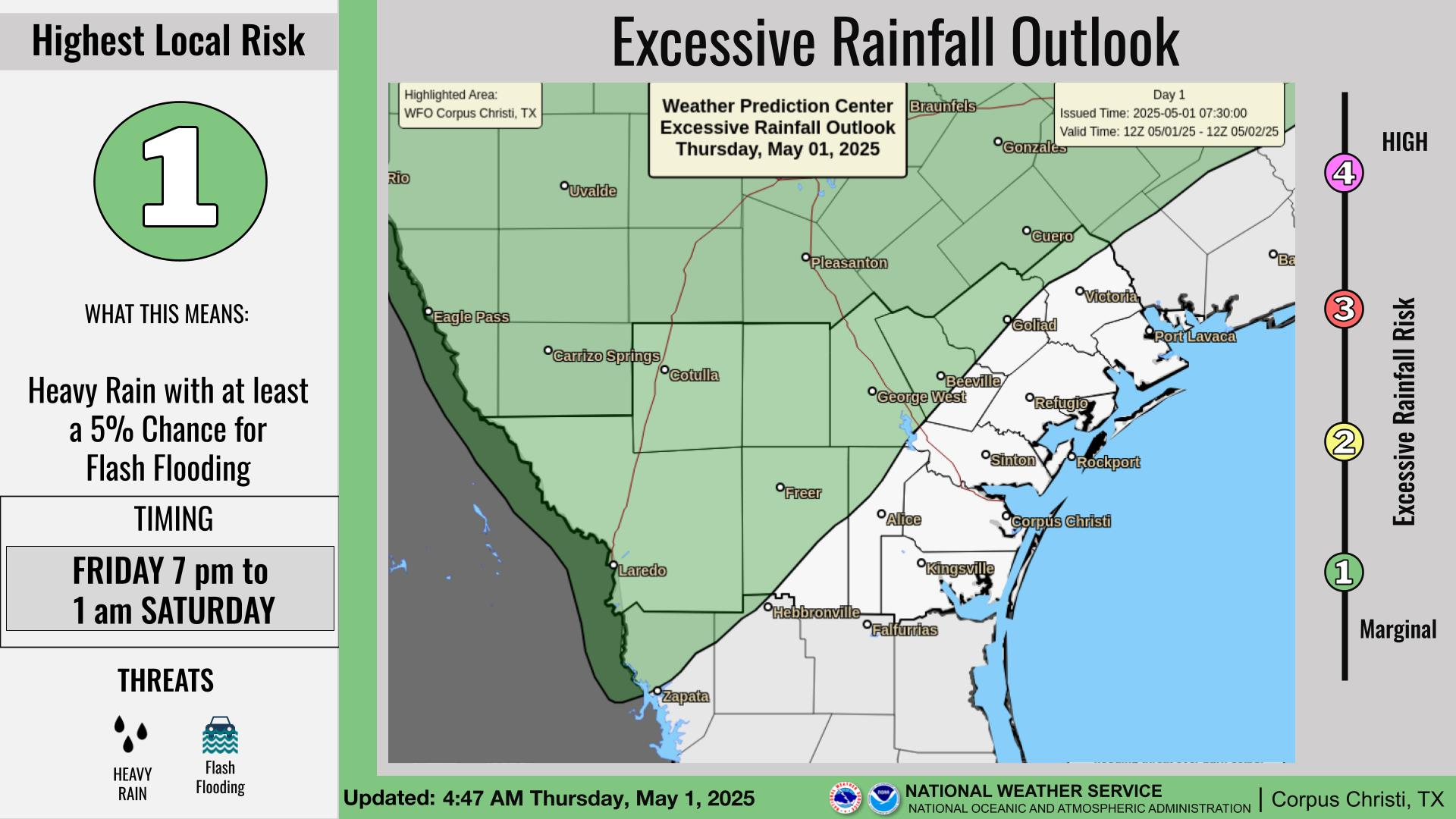
National Weather Service United States Department of Commerce

Dangerous Surf and Rip Currents Along East Coast Beaches; Hazardous Heat in the West

Tropical storm conditions, storm surge flooding and coastal flooding will continue into Thursday across the Outer Banks and into portions of the Mid-Atlantic coastline. Life-threatening rip currents and high surf will continue to impact much of the Atlantic shoreline through the end of the week. Hazardous, record heat will continue across the Western U.S. through the weekend. Read More >

Click a location below for detailed forecast.

Last Map Update: Wed, Aug 20, 2025 at 11:16:47 pm CDT

There are no watches, warnings, or advisories at this time.

Latest Radar Loop
Local pockets of 1-3 inches of rain could lead to isolated instances of flooding on Thursday. Stay weather aware. If you encounter flooding, Turn Around Don't Drown.
It will be mostly cloudy and hot today with highs ranging from around 90 at the beach to 102 over western brush country. Isolated to scattered thunderstorms are possible, primarily out west. Heat risk remains moderate with heat indices climbing to 103-110°F.
Mostly cloudy and warm today with light winds. Isolated thunderstorms. There is a LOW risk of rip currents.
A few evening storms out west and to the north, otherwise high cloudiness tonight with light and variable winds. Lows will range from the mid 70s to around 80.
Scattered to numerous showers and thunderstorms can be expected each day through the weekend as a persistent trough of low pressure resides over South Texas. Pockets of heavy rain will be possible on Thursday. Temperatures will gradually decline through the week with the increased cloud cover and precipitation.

 
Hourly Weather Roundup ( )
Location Sky/Weather Temp Dewpt RH Wind Baro Remarks
Alice
N/A
N/A
N/A
N/A
N/A
N/A
N/A
Beeville
N/A
N/A
N/A
N/A
N/A
N/A
N/A
Corpus Christi
N/A
N/A
N/A
N/A
N/A
N/A
N/A
Corpus Christi NAS
N/A
N/A
N/A
N/A
N/A
N/A
N/A
Cotulla
N/A
N/A
N/A
N/A
N/A
N/A
N/A
Kingsville NAS
N/A
N/A
N/A
N/A
N/A
N/A
N/A
Laredo
N/A
N/A
N/A
N/A
N/A
N/A
N/A
Port Lavaca
N/A
N/A
N/A
N/A
N/A
N/A
N/A
Rockport
N/A
N/A
N/A
N/A
N/A
N/A
N/A
Victoria
N/A
N/A
N/A
N/A
N/A
N/A
N/A
Note: "N/A" or "MISG" will be displayed if values are not available. In the LOCATION column, click on links for a list of recent observations at sites of interest. In the WIND column, VRB is "variable" and G is "gust". Wind speeds are in MPH. In the BARO (pressure) column, values are in inches. In the REMARKS column, HX is "heat index", WCI is "wind chill index", and VSB is "visibility" (if shown).
 
Text Product Selector
Video Briefing Weather Outlook Fcst Discussion Tropical Marine Tides
Rivers and Lakes Daily Rainfall Drought Fire Observations Satellite

Hourly Wx Graph Graphical Fcst Aviation Climate Past Events Hurricane Guide