
Life-threatening and locally catastrophic flash and urban flooding is expected across portions of south-central Texas through early Friday, with significant river flooding and rapid rises on small streams, arroyos, and typically dry washes expected. A significant heat wave continues for the Rockies, Northern Plains, and Great Lakes into the Mid-Atlantic, peaking in intensity through midweek. Read More >
Overview
|
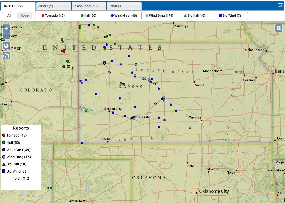
Severe thunderstorms developed along a weak convergence zone from northeast Colorado into southwest Nebraska during the late afternoon on 13 August, 2019. A thunderstorm cluster moving south across western Nebraska merged with the developing thunderstorms and evolved into a forward propagating mesoscale convective system that produced widespread high winds from northwest into central Kansas. The greatest damage occurred in Ellis County, where winds were estimated at near 90 mph. Here is a damage summary KMZ file that is viewable in Google Earth. |
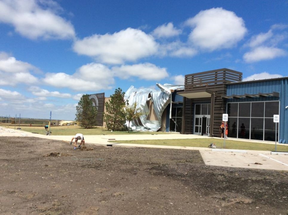 Damage To Church Northwest of Hays |
 |
 |
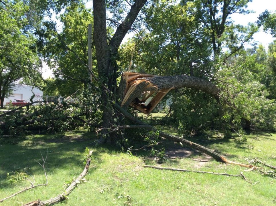 |
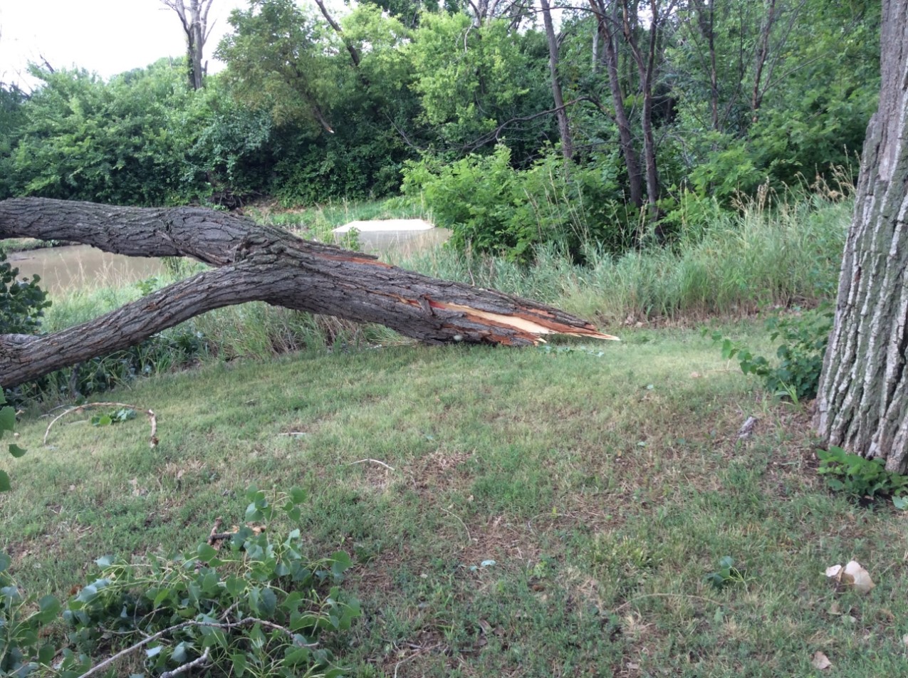
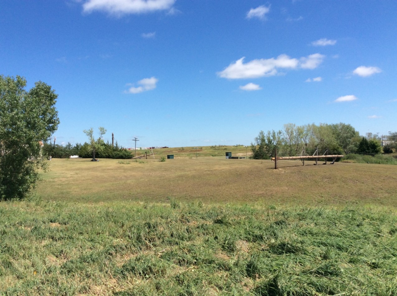
| Tree Damage Ft. Hays Campus | Power Poles Northwest of Hays | Tre Damage in Ellis |
Wind & Hail:
PRELIMINARY LOCAL STORM REPORT...SUMMARY
NATIONAL WEATHER SERVICE DODGE CITY KS
1049 AM CDT THU AUG 15 2019
..TIME... ...EVENT... ...CITY LOCATION... ...LAT.LON...
..DATE... ....MAG.... ..COUNTY LOCATION..ST.. ...SOURCE....
..REMARKS..
0620 PM TSTM WND GST 5 NNE VODA 39.12N 99.99W
08/13/2019 E70 MPH TREGO KS PUBLIC
0647 PM TSTM WND GST HEALY 38.60N 100.62W
08/13/2019 E55 MPH LANE KS TRAINED SPOTTER
ALSO REPORTS OF BLOWING DIRT FROM FIELDS
REDUCING VISIBILITY TO A 1/2 MILE.
0655 PM TSTM WND GST 1 ESE SCOTT STATE LAKE 38.68N 100.90W
08/13/2019 M56 MPH SCOTT KS MESONET
MESONET STATION K5SCT 1 ESE SCOTT STATE
LAKE.
0655 PM TSTM WND GST 1 S WAKEENEY 39.01N 99.88W
08/13/2019 M72 MPH TREGO KS MESONET
MESONET STATION K5WKY 1 SSW WAKEENEY.
0655 PM TSTM WND DMG WAKEENEY 39.03N 99.88W
08/13/2019 TREGO KS PUBLIC
SOCIAL MEDIA PHOTO OF A ROOF BLOWN OFF A
BUILDING IN WAKEENEY.
0715 PM TSTM WND GST ELKHART 37.00N 101.90W
08/13/2019 M55 MPH MORTON KS AWOS
AWOS STATION KEHA ELKHART AWOS SITE.
0715 PM TSTM WND GST DIGHTON 38.48N 100.47W
08/13/2019 M53 MPH LANE KS MESONET
MESONET STATION DW9499 DIGHTON.
0715 PM TSTM WND GST 9 S DIGHTON 38.35N 100.46W
08/13/2019 E60 MPH LANE KS TRAINED SPOTTER
0715 PM TSTM WND GST 2 ESE SCOTT CITY 38.47N 100.88W
08/13/2019 M49 MPH SCOTT KS AWOS
AWOS STATION KTQK SCOTT CITY.
0716 PM TSTM WND DMG ELLIS 38.94N 99.56W
08/13/2019 ELLIS KS PUBLIC
REPORTS OF LIMBS DOWN IN ELLIS.
0724 PM TSTM WND GST 1 NNW ELLIS 38.94N 99.56W
08/13/2019 M69 MPH ELLIS KS MESONET
WEATHER LINK SITE IN ELLIS.
0730 PM TSTM WND DMG 4 E ELLIS 38.94N 99.49W
08/13/2019 ELLIS KS STORM CHASER
REPORTS OF 3 SEMIS ON THEIR SIDE IN THE
WESTBOUND LANE OF I-70.
0735 PM TSTM WND GST ELKHART 37.00N 101.90W
08/13/2019 M70 MPH MORTON KS AWOS
AWOS STATION KEHA ELKHART AWOS SITE.
0747 PM TSTM WND GST 2 NNW HAYS 38.90N 99.34W
08/13/2019 M68 MPH ELLIS KS MESONET
WEATHERLINK SITE HAYS.
0748 PM TSTM WND DMG 3 NW HAYS 38.91N 99.35W
08/13/2019 ELLIS KS PUBLIC
SOCIAL MEDIA REPORT OF A ROOF TAKEN OFF OF A
CHURCH AND LANDED ON A VEHICLE IN THE
PARKING LOT.
0750 PM TSTM WND GST JETMORE 38.09N 99.89W
08/13/2019 E60 MPH HODGEMAN KS PUBLIC
0752 PM TSTM WND GST 3 NW PIERCEVILLE 37.92N 100.72W
08/13/2019 M58 MPH FINNEY KS ASOS
ASOS STATION KGCK GARDEN CITY.
0755 PM TSTM WND GST HAYS 38.85N 99.27W
08/13/2019 M77 MPH ELLIS KS AWOS
AWOS STATION KHYS HAYS REGIONAL AIRPORT AWOS
SITE.
0756 PM TSTM WND GST CATHERINE 38.93N 99.22W
08/13/2019 E70 MPH ELLIS KS PUBLIC
0802 PM TSTM WND GST 5 NW HOWELL 37.82N 100.25W
08/13/2019 E70 MPH GRAY KS TRAINED SPOTTER
0807 PM TSTM WND DMG WRIGHT 37.78N 99.89W
08/13/2019 FORD KS PUBLIC
SOCIAL MEDIA REPORT OF TREE DAMAGE IN
WRIGHT.
0810 PM TSTM WND DMG 1 NNE FT. DODGE 37.75N 99.92W
08/13/2019 FORD KS LAW ENFORCEMENT
REPORTS OF A TRANSFORMER BLOWN OVER WITH
LIVE WIRES ON THE GROUND.
0810 PM TSTM WND GST 1 NNE DODGE CITY 37.78N 100.00W
08/13/2019 M55 MPH FORD KS MESONET
MESONET STATION CW9785 DODGE CITY.
0811 PM TSTM WND GST 3 ENE DODGE CITY 37.77N 99.97W
08/13/2019 M63 MPH FORD KS ASOS
ASOS STATION KDDC DODGE CITY REGIONAL
AIRPORT.
0820 PM TSTM WND DMG HAYS 38.88N 99.32W
08/13/2019 ELLIS KS LAW ENFORCEMENT
FROM HAYS DISPATCH...REPORTS OF 20 SEMIS
BLOWN OVER ACROSS THE COUNTY. KHP IS
REPORTING HIGH VOLTAGE POWER LINES BLOWN
OVER SEMIS.
0830 PM TSTM WND DMG LARNED 38.19N 99.10W
08/13/2019 PAWNEE KS PUBLIC
MULTIPLE REPORTS OF TREES DOWN AND POWER
OUTAGES IN LARNED.
0831 PM TSTM WND GST 3 W BLOOM 37.49N 99.96W
08/13/2019 M55 MPH FORD KS MESONET
MESONET STATION DW9907 BLOOM.
0835 PM TSTM WND GST 2 NNW ULYSSES 37.60N 101.37W
08/13/2019 M47 MPH GRANT KS AWOS
AWOS STATION KULS ULYSSES.
0835 PM TSTM WND GST 1 ENE SUBLETTE 37.48N 100.83W
08/13/2019 M49 MPH HASKELL KS AWOS
AWOS STATION K19S 1 NE SUBLETTE.
0854 PM TSTM WND GST 3 SE HOPEWELL 37.77N 98.96W
08/13/2019 E60 MPH PRATT KS LAW ENFORCEMENT
0858 PM HAIL SYRACUSE 37.98N 101.75W
08/13/2019 E1.00 INCH HAMILTON KS LAW ENFORCEMENT
0903 PM HAIL SYRACUSE 37.98N 101.75W
08/13/2019 E1.75 INCH HAMILTON KS PUBLIC
MULTIPLE REPORTS OF GOLFBALL HAIL FROM
SOCIAL MEDIA PHOTOS.
0908 PM TSTM WND GST 2 E CROFT 37.49N 98.95W
08/13/2019 E60 MPH PRATT KS LAW ENFORCEMENT
0935 PM TSTM WND GST 2 SSW IUKA 37.70N 98.75W
08/13/2019 M58 MPH PRATT KS AWOS
AWOS STATION KPTT PRATT INDUST.
0959 PM TSTM WND GST 10 ENE HUDSON 38.17N 98.50W
08/13/2019 M70 MPH STAFFORD KS CO-OP OBSERVER
CO-OP OBSERVER STATION QNRK1 QUIVERA REMOTE
AUTOMATED WEATHER STATION.
1006 PM TSTM WND GST 2 E MEDICINE LODGE 37.28N 98.55W
08/13/2019 M55 MPH BARBER KS ASOS
ASOS STATION KP28 MEDICINE LODGE.
 |
Media use of NWS Web News Stories is encouraged! Please acknowledge the NWS as the source of any news information accessed from this site. |
|

