Overview
A wintry mix of precipitation associated with a low pressure system impacted Southeast Michigan through most of the day on February 27th while lighter snow continued through the early overnight hours further north. A pronounced transition zone developed between areas that received mostly rain (south of I-96) and areas that received mostly snow (north of M-46). A Winter Weather Advisory was in effect between the late morning hours and early evening hours along/north of M-59. The first wave of precipitation moved in from the southwest with most locations initially receiving a mix of sleet and freezing rain as surface temperatures hovered near freezing and modest east wind facilitated the influx of drier air. Precipitation rates increased midday with periods of heavy rain and sleet across the south while areas to the north experienced a quick burst of snow mid afternoon. At one point, the northern tier of counties (Midland, Bay, and Huron) experienced snowfall rates in excess of an inch per hour leading to the snowfall totals of 4-8 inches. Additional light snow showers north of I-69 concluded with the departure of the wave after midnight. Icing from a freezing rain/sleet mix was most prevalent between M-59 and I-69 which led to re-icing of trees and utility lines which were then subjected to wind gusts of up to 35 mph. This led to additional delays in power restoration, just five days after an even more impactful ice storm.
Ice & Snow Totals
STORM TOTAL FREEZING RAIN REPORTS
Location Precip Duration
(Inches) (Hours) Lat Lon
...Lapeer County...
2 NW Columbiaville M 0.10 M 43.18N 83.44W
...Oakland County...
1 NW Clarkston E 0.20 M 42.75N 83.43W
4 E White Lake M 0.20 M 42.65N 83.43W
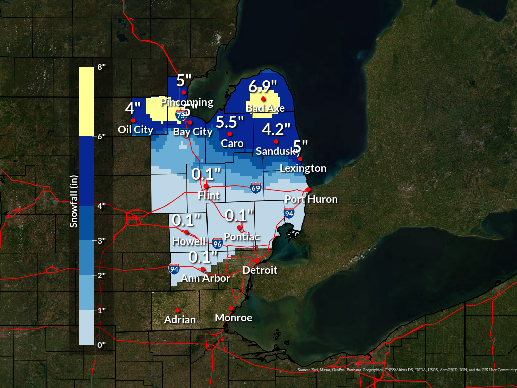
STORM TOTAL SNOW REPORTS
Location Snowfall Duration
(Inches) (Hours) Lat Lon
...Bay County...
2 NW Bay City M 3.0 6 43.61N 83.92W
2 E Bay City M 4.4 6 43.59N 83.85W
Bay City M 5.0 6 43.59N 83.89W
Pinconning M 5.0 6 43.86N 83.96W
Auburn M 5.8 14 43.60N 84.08W
...Midland County...
Oil City M 4.0 14 43.61N 84.59W
4 SW Midland M 4.1 5 43.58N 84.29W
2 E Oil City M 4.5 2.5 43.61N 84.55W
Midland M 6.3 5 43.62N 84.23W
Hope M 7.0 6 43.76N 84.34W
Sanford M 8.0 6 43.68N 84.38W
...Huron County...
Port Austin M 4.0 12 44.04N 83.00W
Bad Axe M 6.9 12 43.80N 83.00W
...Saginaw County...
5 S Auburn M 2.0 3 43.53N 84.08W
...Tuscola County...
Caro M 5.5 13 43.49N 83.40W
Cass City M 6.0 13 43.60N 83.18W
...Sanilac County...
Deckerville M 5.0 6 43.53N 82.74W
Lexington M 5.0 12 43.27N 82.53W
M = MEASURED
E = ESTIMATED

$$
 |
|
Storm Total Snow |
Radar
|
|
|
Radar: NEXRAD mosaic base reflectivity radar loop from 630 AM Feb 27, 2023 through 3 AM Feb 28, 2023.
|
Environment
A strong upper level shortwave trough translated from the southwest CONUS into the Great Lakes drawing an expansive sub-tropical moisture plume that fueled a large area of rain and wintry precipitation across the southern Great Lakes. An elevated warm front lifted northward in advance of the surface low center which led to a jump in 850 mb temps from near 0C at 7 AM (Figure 1) to almost 5C by 7 PM (Figure 3) with a 50 knot low-level jet nose. This saturated warm layer aloft ensured any frozen precipitation falling above the warm layer would be nearly melted by the time it reached the surface, thus the widespread mix of freezing rain and sleet, supported by the easterly feed of dewpoints in the 20s. The surface warm front remained south of the Michigan/Ohio border by 18Z (Figure 2) as the low occluded and moved due eastward. Along/south of I-96, slight diurnal warming allowed surface temperatures to climb above freezing limiting ice accumulations to elevated surfaces.
Farther south, heavy rainfall occurred with elevated instability as mid-level lapse rates approached 6.5 C/km. This coincided with the strongest axis of FGEN that translated across the Michigan/Ohio border during the afternoon period, particularly within the 925-850 mb layer (Figures 5, 6). Rainfall totals exceeded an inch in several locations across Lenawee, Monroe, Washtenaw, and Wayne counties. Detroit set a new daily record rainfall record of 1.23 inches while isolated reports of an inch and a half were realized further south. Centering along the I-69 corridor, more efficient icing was realized with approximately 0.10-0.25 inches of ice reported. Given slightly cooler surface temperatures, these areas remained below freezing leading to a distribution of predominantly freezing rain through the bulk of the event which was maintained by evaporative cooling.
North of the M-46 corridor, a combination of colder column temperatures, strong vertical velocities, secondary FGEN axis, and efficient wet-bulbing led to a period of heavy snowfall for portions of Midland, Bay, Tuscola, Huron, and Sanilac Counties with isolated areas of thunder snow. Snowfall rates in excess of an inch per hour were noted such as at Auburn, Sanford, and Cass City leading to whiteout conditions at times during the afternoon before the arrival of the dry slot and temperatures near 30F. Given the colder temperatures and the lack of interference from the elevated warm front, this area of enhanced snowfall was able to maintain an all-snow character through the event which helped boost SLRs given a lack of riming or sleet mix.
 |
 |
|
Figure 1: DTX Sounding Valid Feb 27 2023 12UTC |
Figure 2: WPC Surface Analysis Valid Feb 27 2023 18UTC |
 |
 |
|
Figure 3: DTX Sounding Valid Feb 28 2023 00UTC |
Figure 4: WPC Surface Analysis Valid Feb 28 2023 03UTC |
 |
 |
|
Figure 5: SPC 925-850 mb FGEN Valid Feb 27 2023 18UTC |
Figure 6: SPC 925-850 mb FGEN Valid Feb 27 2023 20UTC |
 |
Media use of NWS Web News Stories is encouraged! Please acknowledge the NWS as the source of any news information accessed from this site. |
|