
Dangerous heat will expand from the Gulf Coast into the Southern Plains and Desert Southwest through week's end. Additional extreme heat impacting the Pacific Northwest will shift to the northern Plains by the weekend. Tropical Storm Bertha is expected to continue to impact portions of the northern Gulf Coast from the western Florida Panhandle to southeastern Louisiana through tonight. Read More >
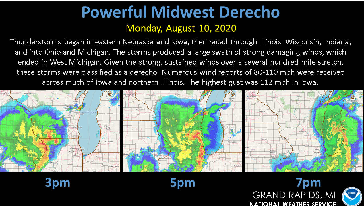
Summary of Severe Weather on August 10
August 10, 2020 Derecho in Southwest Michigan
 |
|
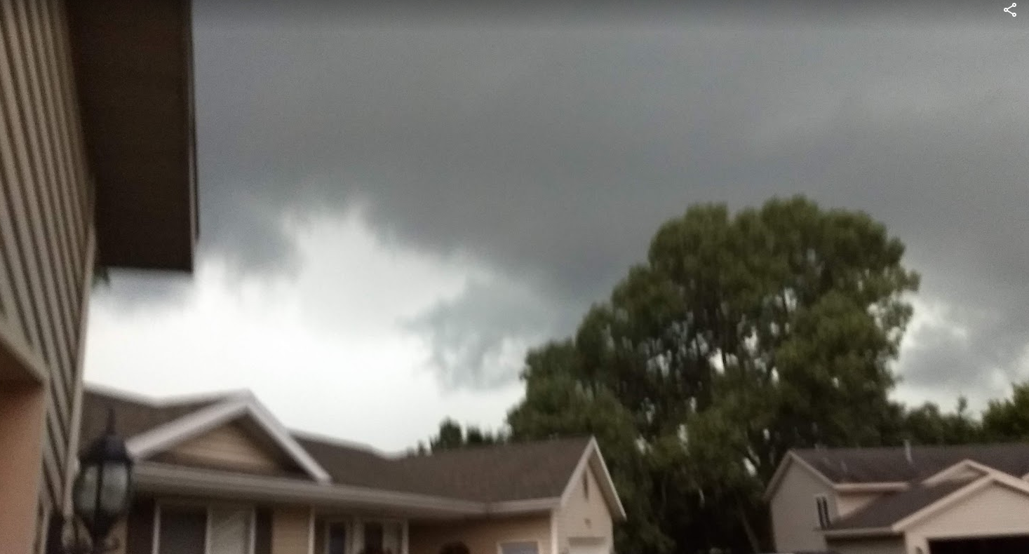
Shelf cloud crossing the west side of Grandville |
Thunderstorms began in eastern Nebraska and Iowa, then raced through Wisconsin, Illinois, Indiana and Michigan. The storms produced a large swath of strong damaging winds, which ended in West Michigan. As the strong winds extended over a several hundred mile stretch, these storms were classified as a derecho. Numerous wind reports of 80 to 110 mph were received across much of Iowa and northern Illinois. The highest gust was 112 mph in Iowa.
Links to Other NWS stories on this storm:
SPC Unfiltered Reports for August 10th, 2020
PRELIMINARY LOCAL STORM REPORT...SUMMARY
NATIONAL WEATHER SERVICE GRAND RAPIDS MI
345 AM EDT TUE AUG 11 2020

..TIME...   ...EVENT...      ...CITY LOCATION...     ...LAT.LON...
..DATE...   ....MAG....      ..COUNTY LOCATION..ST.. ...SOURCE....
            ..REMARKS..

0448 AM     TSTM WND GST     2 WSW GOBLES            42.35N 85.92W
08/10/2020  M30 MPH          VAN BUREN          MI   MESONET

            MESONET STATION EW1083 GOBLES.

0530 AM     TSTM WND GST     MACATAWA                42.77N 86.20W
08/10/2020  M31 MPH          OTTAWA             MI   BUOY

            BUOY STATION HLNM4 HOLLAND HARBOR.

0648 PM     TSTM WND GST     LAWTON                  42.17N 85.85W
08/10/2020  E45 MPH          VAN BUREN          MI   TRAINED SPOTTER

            GUST FRONT OUT AHEAD OF RAIN WITH GUSTS
            ESTIMATED 40 TO 45 MPH.

0652 PM     TSTM WND DMG     MATTAWAN                42.21N 85.79W
08/10/2020                   VAN BUREN          MI   PUBLIC

            SOME TREES DOWN.

0655 PM     MARINE TSTM WIND 1 NNW SOUTH HAVEN       42.41N 86.28W
08/10/2020  M43 MPH          VAN BUREN          MI   BUOY


0656 PM     TSTM WND DMG     5 NW DECATUR            42.16N 86.04W
08/10/2020                   VAN BUREN          MI   PUBLIC

            TREES DOWN ALONG WESTERN TERRITORIAL ROAD.

0659 PM     TSTM WND DMG     GOBLES                  42.36N 85.88W
08/10/2020                   VAN BUREN          MI   PUBLIC

            SOME TREES DOWN.

0719 PM     TSTM WND DMG     1 N NORTH DORR          42.78N 85.76W
08/10/2020                   KENT               MI   PUBLIC

            SMALL SHED DAMAGED AND ISOLATED TREE DAMAGE.

0725 PM     TSTM WND DMG     PLAINWELL               42.44N 85.64W
08/10/2020                   ALLEGAN            MI   TRAINED SPOTTER

            8 INCH DIAMETER TREE DOWN ACROSS M89 IN
            PLAINWELL.

0735 PM     TSTM WND DMG     1 N SOUTH GULL LAKE     42.40N 85.40W
08/10/2020                   KALAMAZOO          MI   PUBLIC
0615 PM     TSTM WND GST     ST JOSEPH PIER          42.12N 86.49W
08/10/2020  M57 MPH          LMZ844             MI   MESONET

            MESONET STATION XSTJ ST. JOSEPH PIER.

0640 PM     TSTM WND GST     1 W SOUTH HAVEN         42.40N 86.29W
08/10/2020  M45 MPH          LMZ844             MI   MESONET

            MESONET STATION SVNM4 SOUTH HAVEN.

0642 PM     TSTM WND GST     2 NNW SAUGATUCK         42.68N 86.22W
08/10/2020  M47 MPH          LMZ845             MI   MESONET

            MESONET STATION XSTK SAUGATUCK PIER.

0706 PM     TSTM WND GST     MACATAWA                42.77N 86.20W
08/10/2020  M45 MPH          OTTAWA             MI   MESONET

            MESONET STATION HLNM4 HOLLAND HARBOR.

0713 PM     TSTM WND GST     3 NE PORTAGE            42.23N 85.55W
08/10/2020  M47 MPH          KALAMAZOO          MI   ASOS

            ASOS STATION KAZO KZOO/BATTLE CREEK INTL
            AIRPORT.

0715 PM     TSTM WND GST     4 SSE SOUTH HAVEN       42.35N 86.25W
08/10/2020  M43 MPH          VAN BUREN          MI   AWOS

            AWOS STATION KLWA SOUTH HAVEN RGNL ARPT.

0739 PM     TSTM WND GST     4 WNW ROOSEVELT PARK    43.22N 86.35W
08/10/2020  M48 MPH          LMZ847             MI   MESONET

            MESONET STATION XMSK MUSKEGON NORTH
            BREAKWATER LIGHT.

0740 PM     TSTM WND GST     4 WNW ROOSEVELT PARK    43.23N 86.34W
08/10/2020  M46 MPH          MUSKEGON           MI   MESONET

            MESONET STATION MKGM4 3 WNW ROOSEVELT PARK.

0745 PM     TSTM WND GST     2 SSW CASCADE           42.88N 85.52W
08/10/2020  M45 MPH          KENT               MI   ASOS

            ASOS STATION KGRR GERALD R FORD INTL.

0831 PM     TSTM WND GST     3 ENE SANDSTONE         42.27N 84.47W
08/10/2020  M47 MPH          JACKSON            MI   ASOS

            ASOS STATION KJXN JACKSON COUNTY-REYNOLDS
            FIELD AIRPORT.
Thank you to everyone who submitted damage reports, photos, and videos!
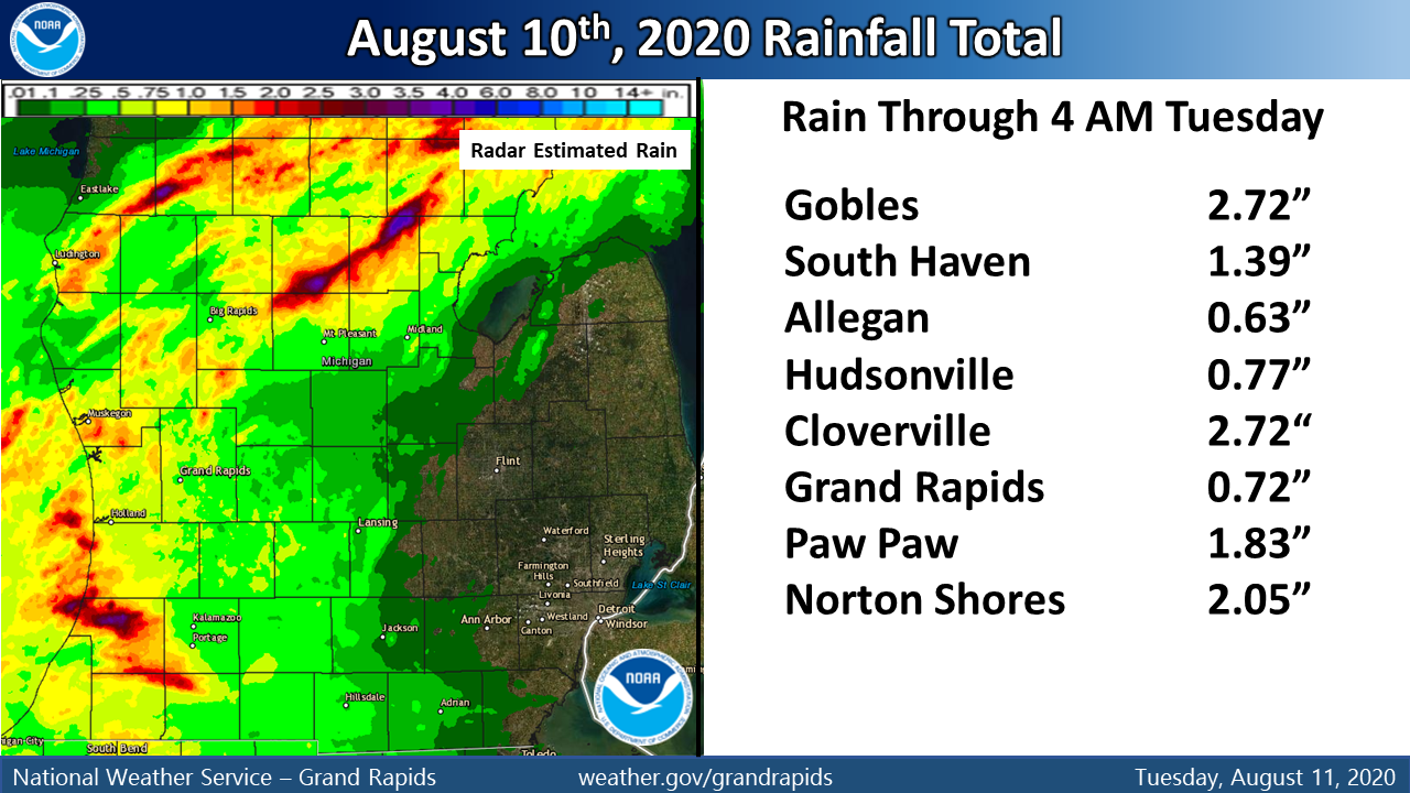
Heavy Rainfall
Along with the damaging winds, portions of Lower Michigan received heavy rainfall. The heaviest rainfall amounts were in Van Buren County and north of a line from Fremont to Alma. Gobles and Cloverville had the highest reported rainfall of 2.72 inches.
 />
/>
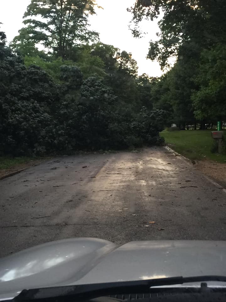
Damage Pictures
 |
 |
|
West of Decatur (Van Buren County) Photo courtesy of John Cathy Goodrich |
Leighton Township (Allegan County) Photo courtesy of Phillip Holscher |
 |
 |
|
Grand Haven (Ottawa County) Photo courtesy of Kerri Bolitho Young |
Leighton Township (Allegan County) Photo courtesy of Phillip Holscher |
 |
|
|
Gull Lake (Kalamazoo County) Photo courtesy of Ken Kissinger |
Radar
Radar Reflectivity as Derecho Moves Into Southwest Michigan August 10th 2020
August 10 2020 Derecho Velocity Image Loop from Grand Rapids Radar
Marine
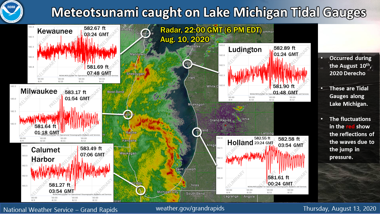
As the Derecho moved across Lake Michigan it caused a Meteotsunami. For more information follow this link.
Below are two images that show what happened as this line of storms moved across Lake Michigan. The rapid increase in pressure captured in red caused an increase of wave heights showed in the second image.
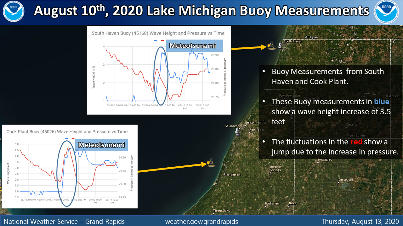
Below was a report from a NWS Employee who was at South Haven, MI.
..TIME...   ...EVENT...      ...CITY LOCATION...     ...LAT.LON...
..DATE...   ....MAG....      ..COUNTY LOCATION..ST.. ...SOURCE....
            ..REMARKS..

0640 PM     SEICHE           1 WNW SOUTH HAVEN       42.40N 86.28W
08/10/2020                   LMZ844             MI   NWS EMPLOYEE

            DELAYED REPORT. OBSERVED WATER RISE OF 1.5
            FT AT SOUTH HAVEN.
 |
Media use of NWS Web News Stories is encouraged! |
|

