 |
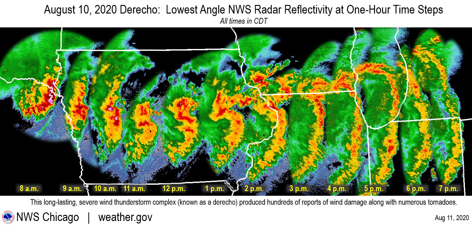
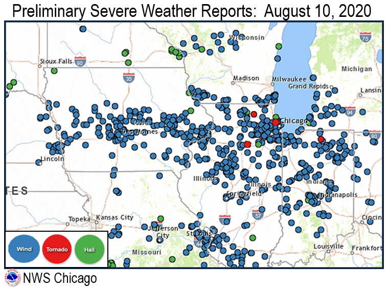
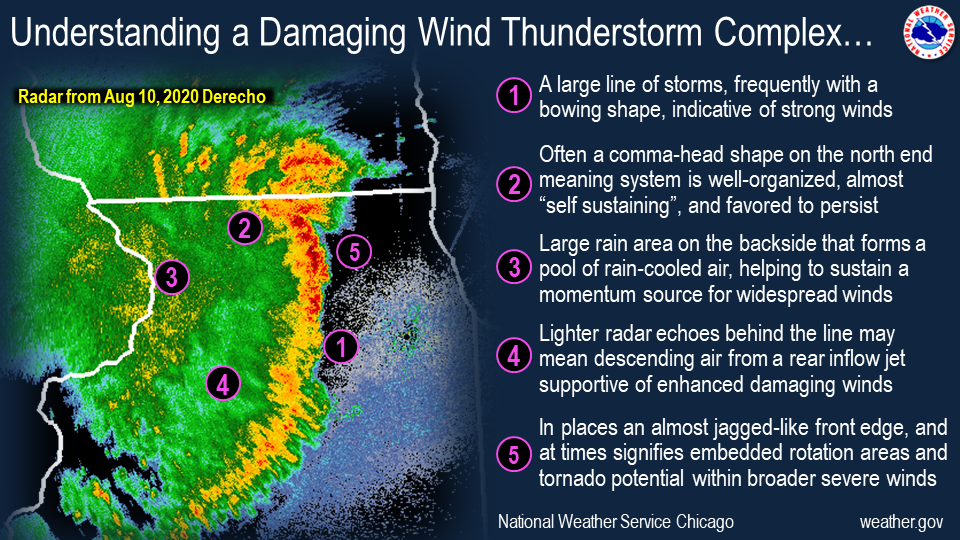
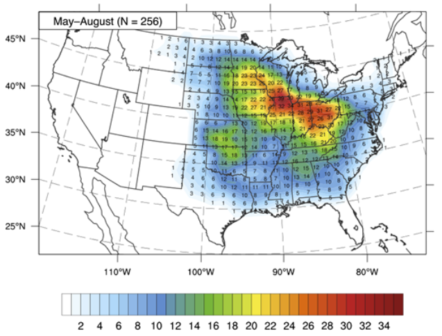
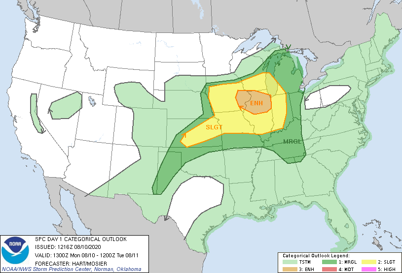
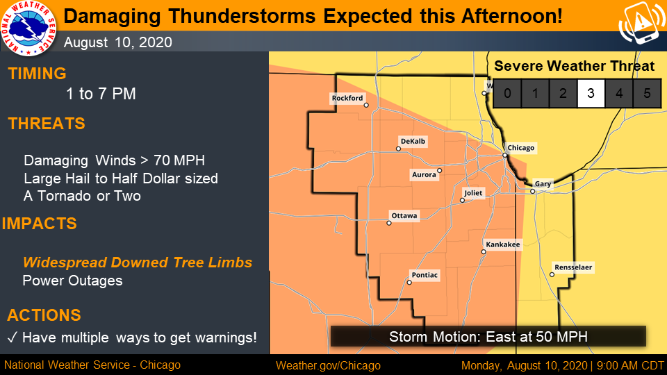
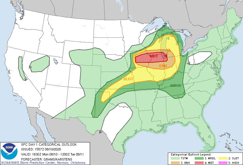
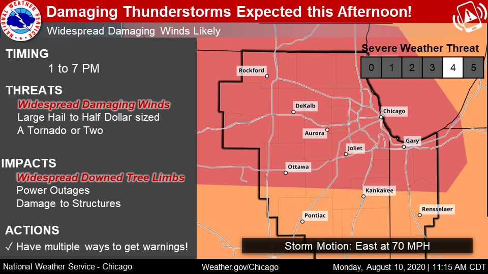
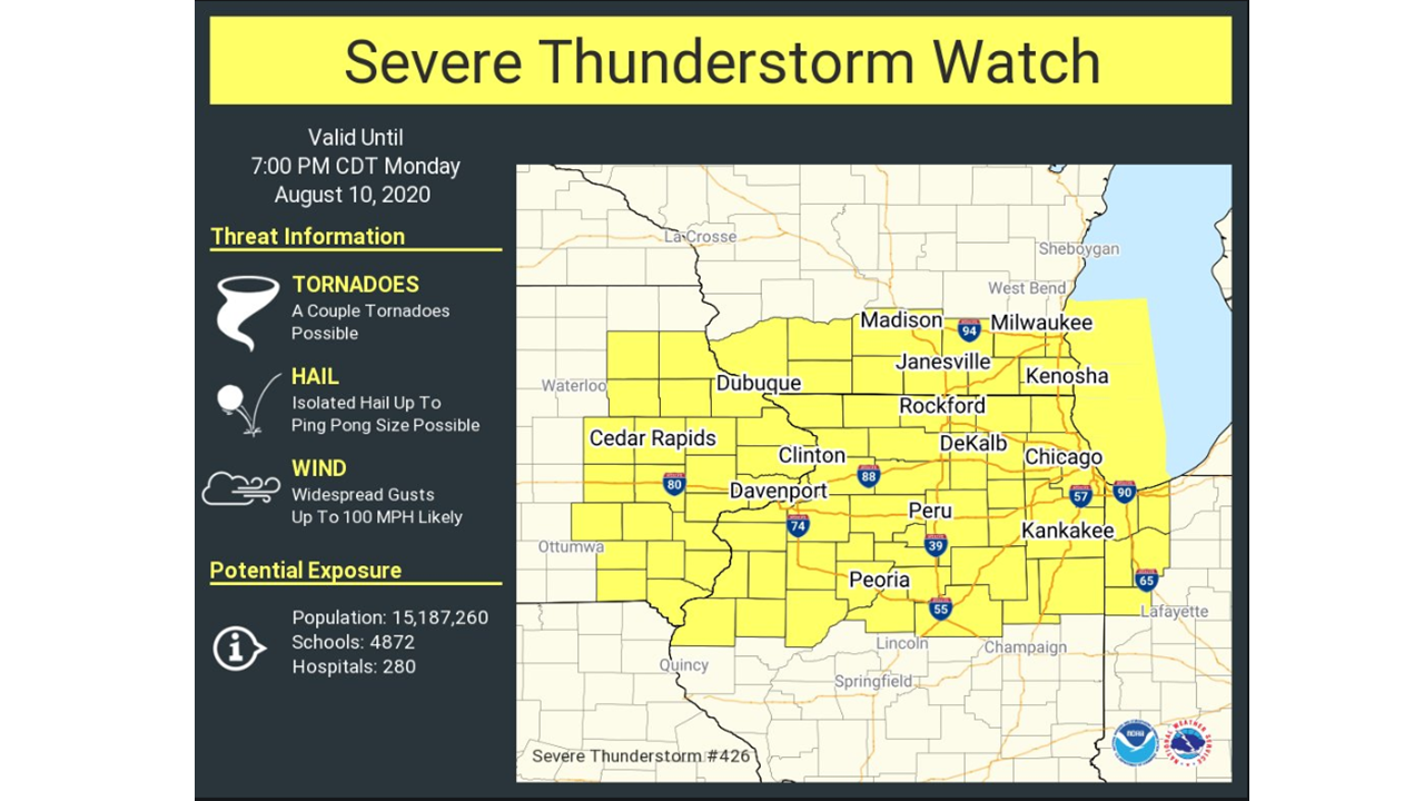
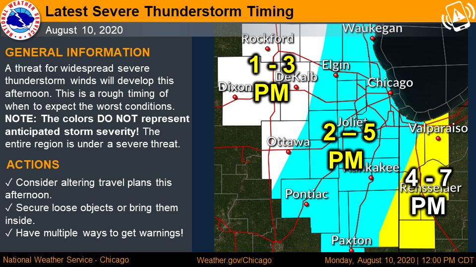
On August 10, 2020, a large and intense line of thunderstorms known as a "derecho" swept across much of the Midwest, producing wind damage to an area larger than 90,000 square miles. The derecho resulted in $11.5B worth of damage, making it the COSTLIEST known thunderstorm event in modern U.S. history. Peak wind gusts topped 140 mph in Cedar Rapids, Iowa, and at least 26 tornadoes were spawned by the storm. More than 20,000,000 people lived in the damage footprint of the derecho, with at least 1,000,000 customers losing power -- some for more than two weeks. Numerous injuries were counted after the storm, and four people lost their lives.
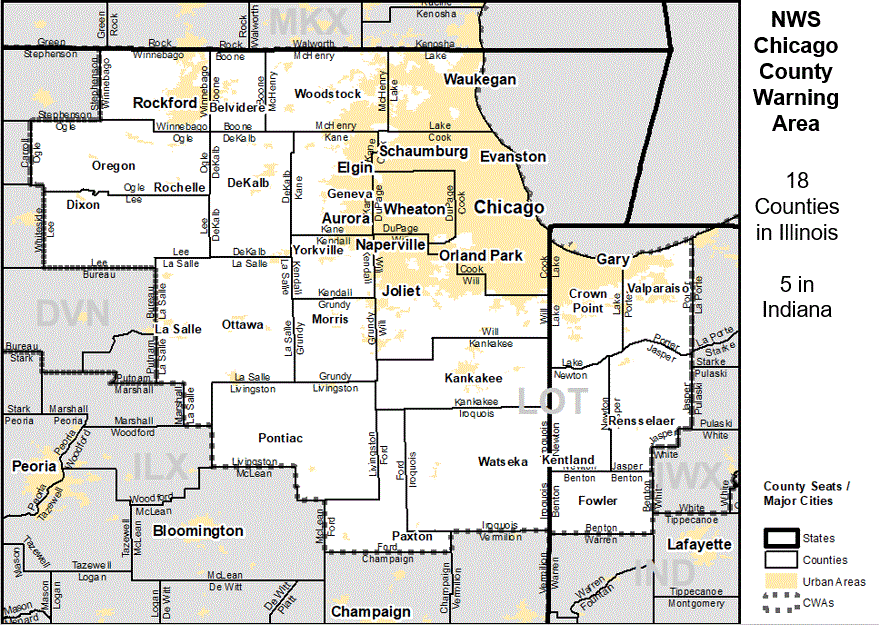
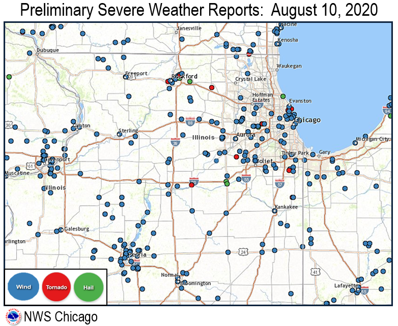
In the NWS Chicago County Warning Area (CWA), over 160 reports of damaging winds were received and 15 tornadoes were confirmed, including an EF-1 tornado in the Rogers Park community area of Chicago. The derecho stands as one of the most impactful weather events to ever impact the NWS Chicago County Warning Area.
August 10, 2020, Midwest Derecho Story Map
Fast Facts:
|
||||||||||||||||||||||
Storm Reports
 |
 |
||
| Regional Storm Reports | Local Storm Reports | ||
| For interactive maps of storm reports, visit this web page. | |||
In the NWS Chicago County Warning Area, over 160 reports of damaging winds were received and 15 tornadoes were confirmed, including an EF-1 tornado in the Rogers Park community area of Chicago. Click on the links below for quality-controlled reports of damage produced by the derecho:
Winnebago, Boone, McHenry, Lake, Ogle, Lee, DeKalb, Kane, DuPage, Cook, La Salle, Grundy, Kendall, Will, Kankakee, Livingston, Ford, and Iroquois
Lake, Porter, Newton, Jasper, and Benton
Tornadoes:
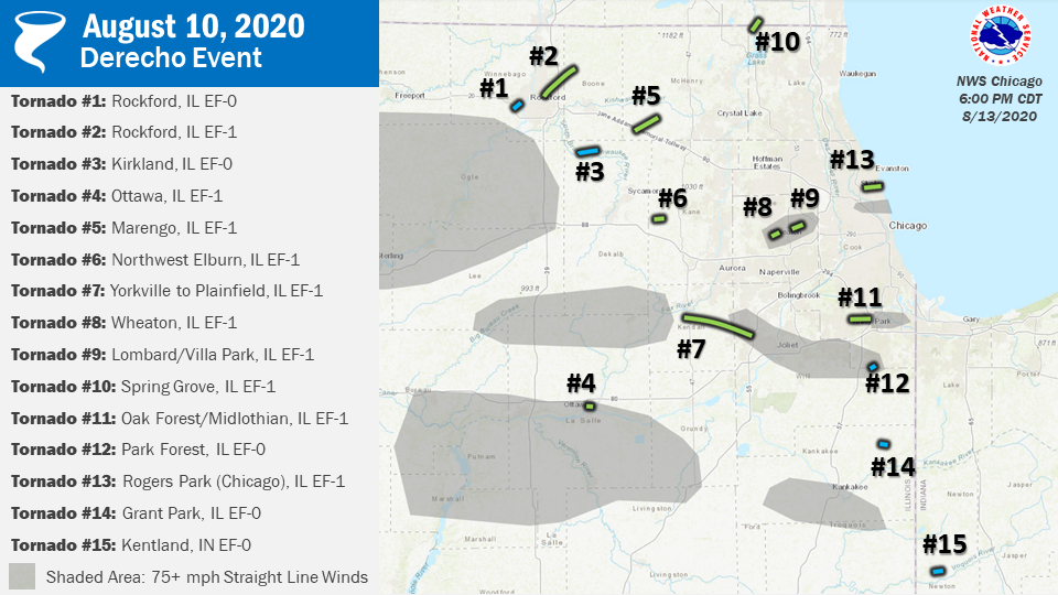
A total of 15 tornadoes were confirmed across northern Illinois and northwest Indiana in the NWS Chicago County Warning Area.
 |
Full Public Information Statement on the tornadoes
Downloadable KMZ file featuring all tornado paths and wind swaths/damage
Downloadable shapefile featuring all tornado paths and wind swaths/damage
Tornadoes are listed in chronological order:
|
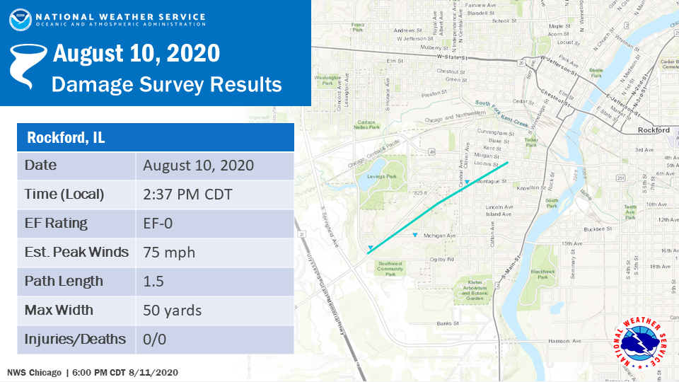
Tornado #1: Southwest Rockford, IL EF-0
Summary: A very brief tornado touched down near the intersection of Pierpont Ave. and Montague Road and continued northeast through the southwest side of Rockford. The tornado ended near the intersection of Ferguson and Loomis Streets. All damage was to trees along the tornado path. |
|
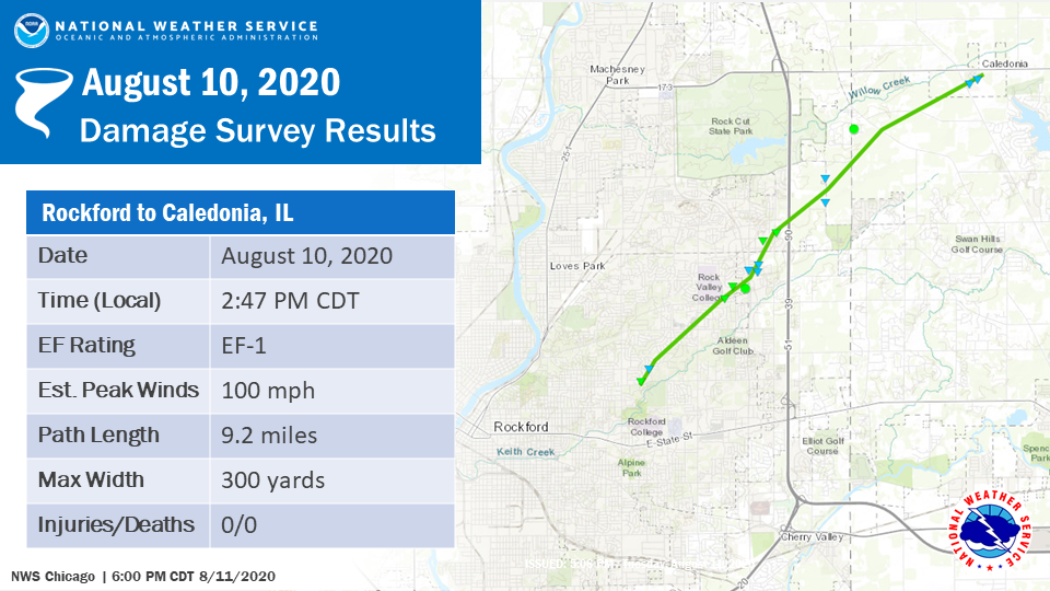
Tornado #2 - Rockford to Caledonia, IL EF-1
Summary: This tornado was associated with the same supercell thunderstorm that produced an initial brief EF-0 tornado on the southwest side of Rockford, but it has been determined these exist as two separate tracks. This tornado developed as the main line of thunderstorms caught up, and eventually merged with, the parent supercell with this path starting near Guilford Road just north of Rockford College before heading northeast. Significant tree damage, consistent with EF-1 wind speeds, occurred in a localized area immediately east of Rock Valley College west of North Perryville Road. The tornado continued northeast, crossing I-90/39, producing sporadic damage before lifting near Caledonia Road. |
|
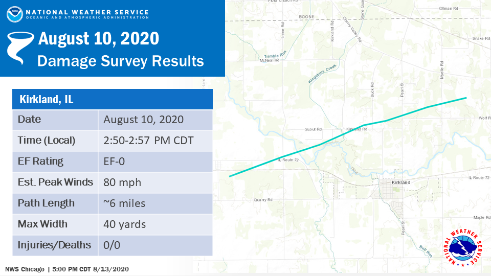
Tornado #3 - Kirkland, IL EF-0
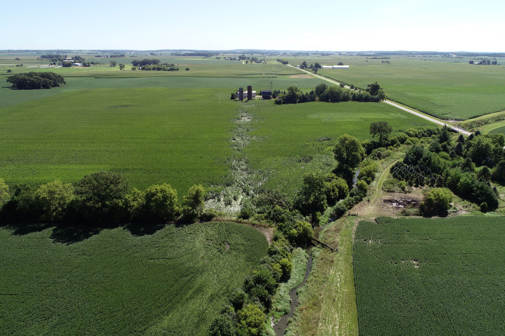
Summary: Drone footage shared with NWS Chicago, as well as satellite imagery, revealed a narrow swath of corn flattened in a convergent pattern. This tornado crossed Buck Road and Pearl Street before lifting in a field east of Myelle Road. |
|
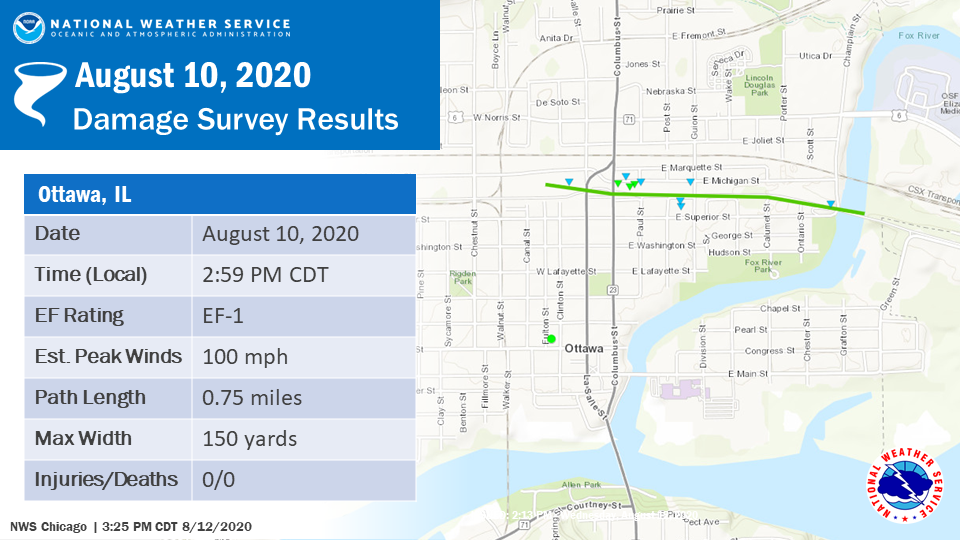
Tornado #4 - Ottawa, IL EF-1
Summary: The tornado started south of Marquette Street west of Michigan Street and progressed eastward. The tornado impacted several businesses, ripping off well-anchored roofing material and snapping a power pole at its base. It was here that the max intensity of the tornado was reached, with peak winds of around 100 mph. The tornado then continued eastward, ripping shingles off roofs of buildings and houses just west of Route 23 and shredding trees. The tornado is believed to have lifted in an inaccessible forested area east of the Fox River. Eyewitnesses indicated the tornado may have had multiple vortices with clear rising and rotating motion of debris. |
|
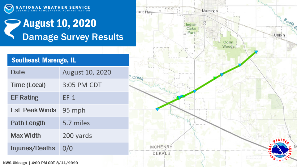
Tornado #5 - Southeast Marengo, IL EF-1
Summary: This EF-1 tornado started on Harmony Road immediately southwest of I-90 near the McHenry/DeKalb County line. Tree damage consistent with winds around 95 mph occurred immediately northeast of I-90. The tornado heavily damaged a single family home near Maple Street before heading northeast and lifting near Coral and Dunham Roads. |
|
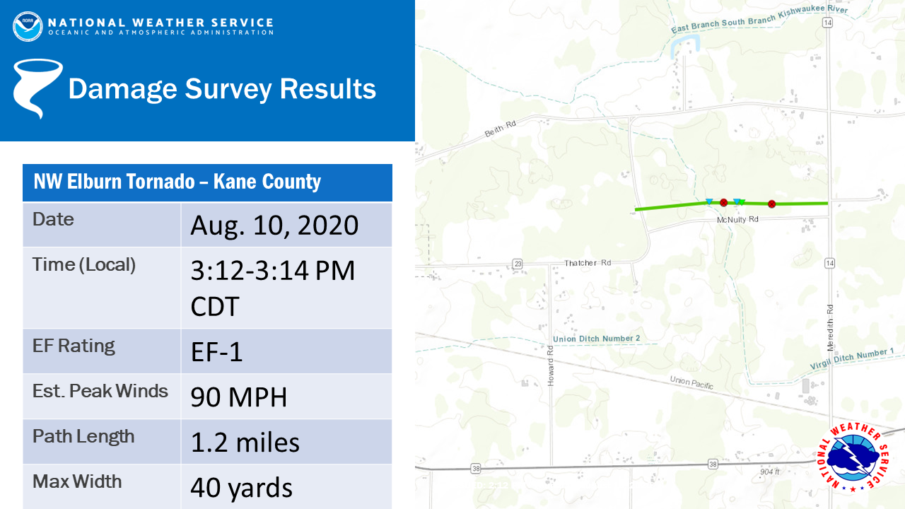
Tornado #6 - Northwest Elburn, IL EF-1
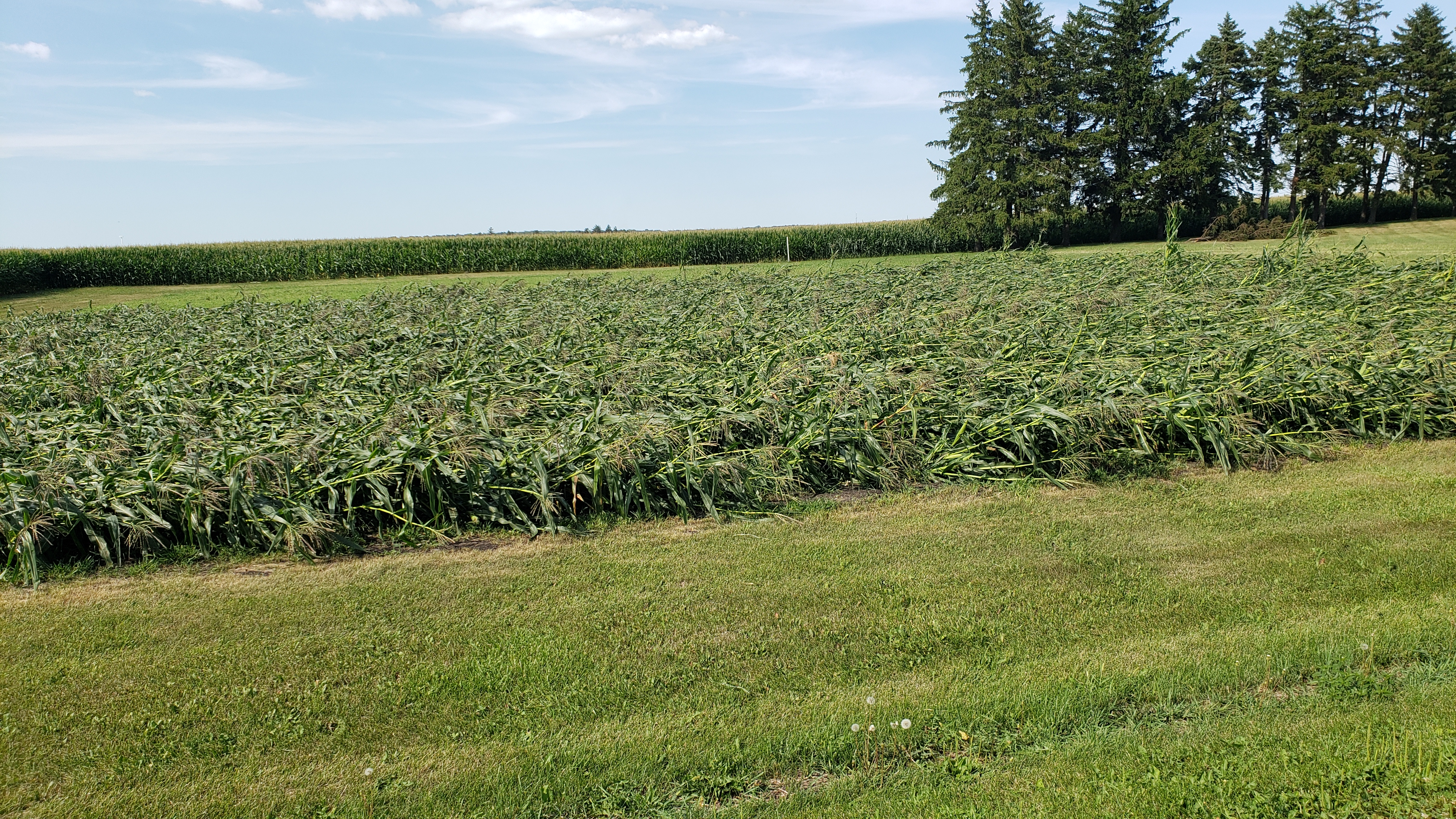
Summary: Drone footage shared with NWS Chicago revealed a narrow swath of corn flattened in a convergent pattern. In addition, damage to a barn was noted, with a near complete removal of the gabled roof. This damage is consistent with a tornado with winds of EF-1 intensity. |
|
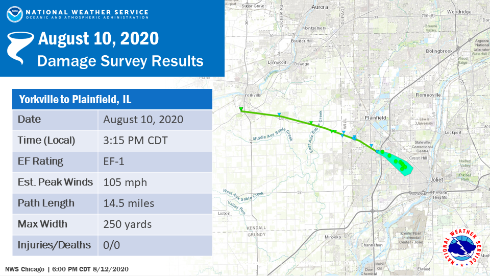
Tornado #7 - Yorkville to South Plainfield EF-1
|
||||||
|
||||||
|
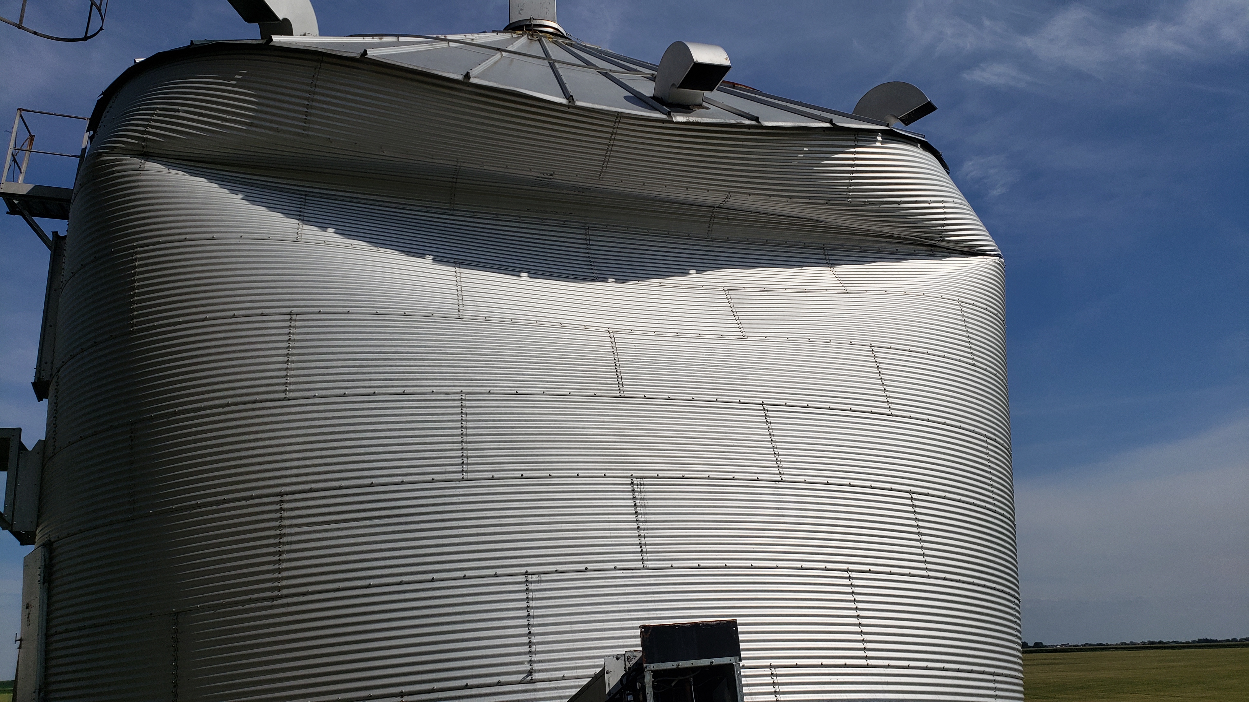
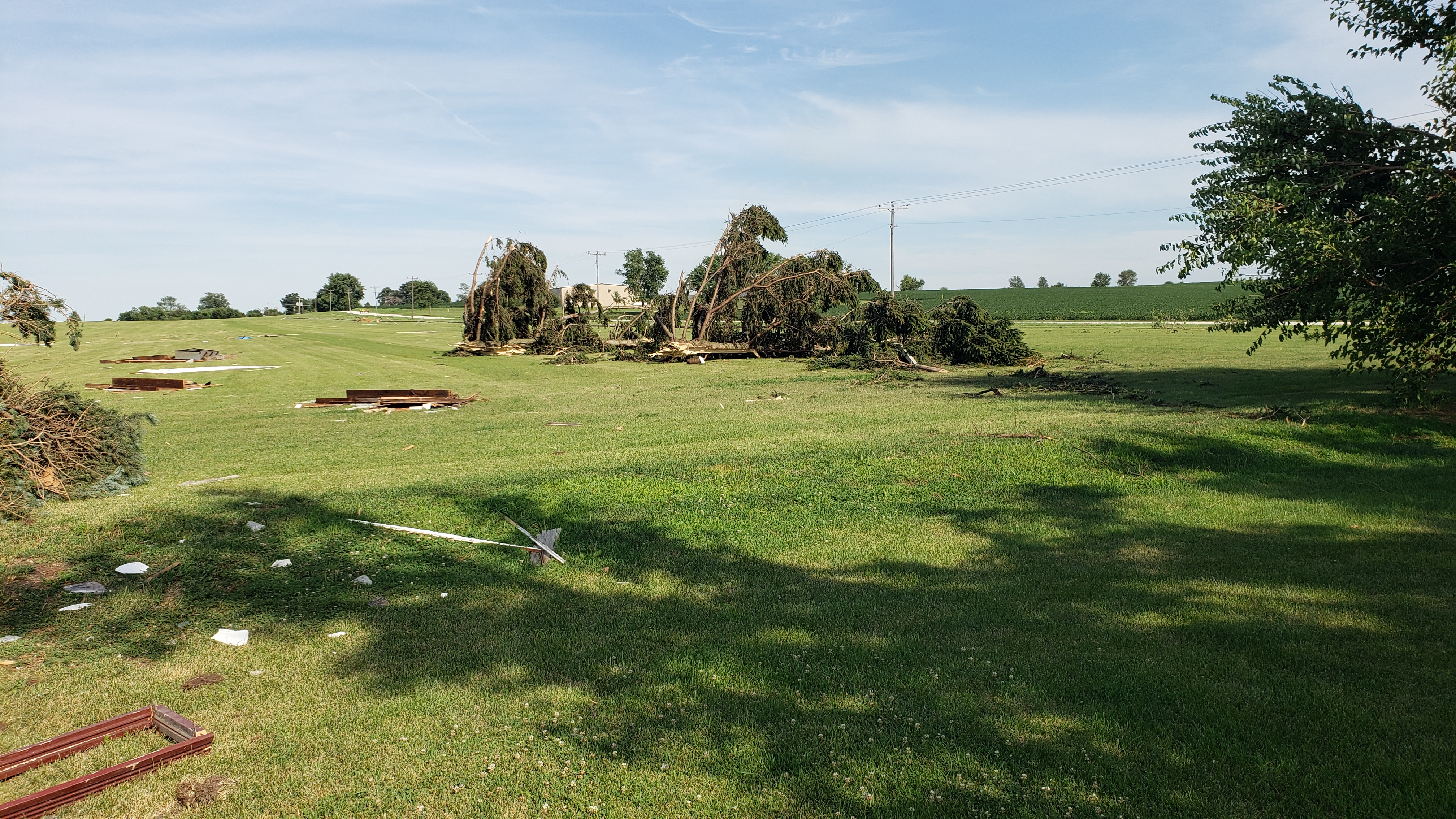
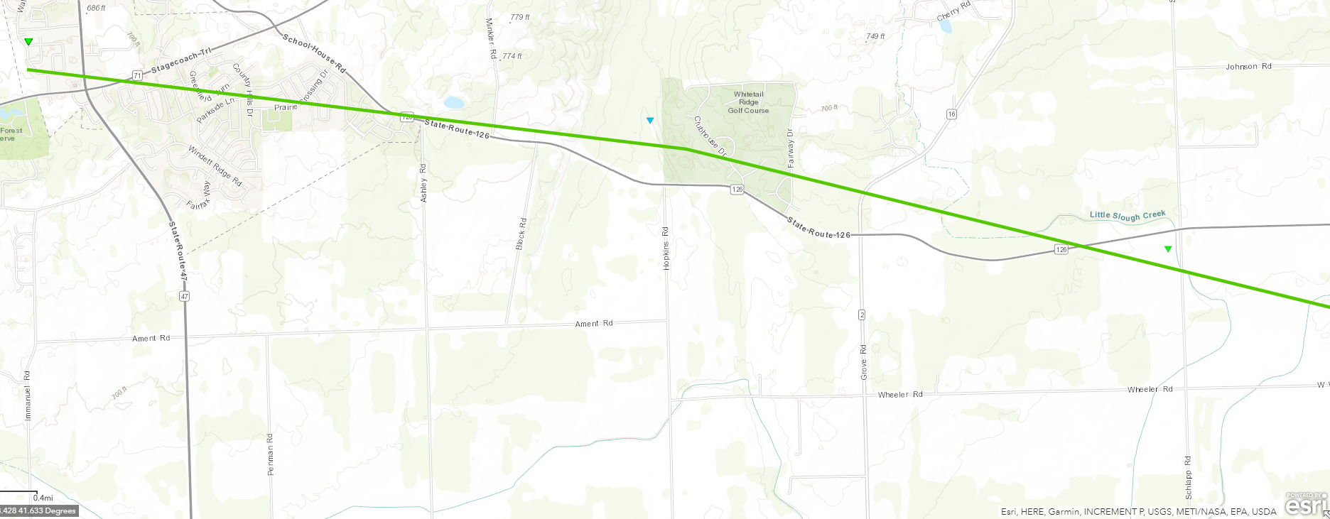
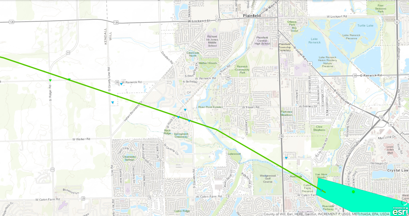
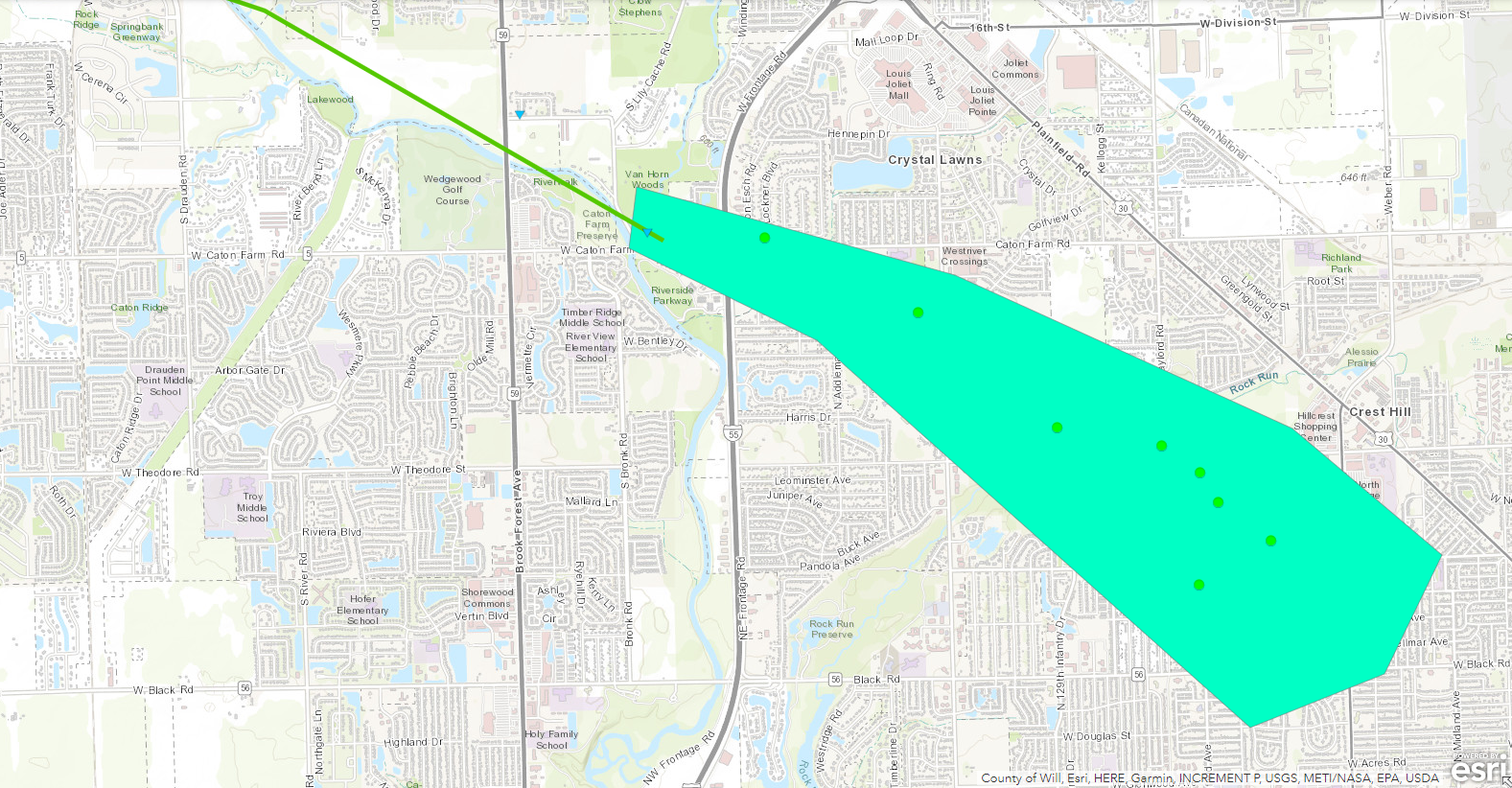
Summary: The tornado started on the far south side of Yorkville near Walsh Drive, where a pergola was destroyed, siding was ripped off a house, and parts of a fence and a tree were thrown over a roadway. Eyewitness accounts indicate the debris was lifted and twirled, consistent with a tornado. The tornado then progressed east-southeastward, producing damage to trees along State Route 126 toward Schlapp Road. The most significant damage was found east of Schlapp Road along Wheeler road, where trees were mangled, a farm building was destroyed with debris deposited in a nearby field, and a large grain bin was bent inward. Wood panels were thrown into the ground, leaving scour marks in the grass. Six power poles were snapped along Ridge Road, and a 1000-1500 lb auger was moved about 50 feet. This is where the tornado likely reached peak intensity with winds near 105 mph. The tornado continued southeast into neighborhoods south of Renwick Road, producing mainly tree damage, and ended just before I-55. A swath of damaging winds consistent with speeds of 70 to 80 mph continued into Crest Hill based on prolific tree damage. |
||||||
|
Tornado #8 - Wheaton, IL EF-1
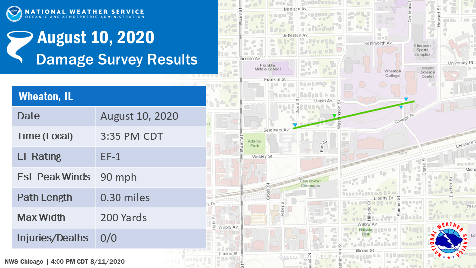
Summary: A very brief tornado touched down near the intersection of Seminary Avenue and Scott Street before moving northeast, where it toppled a roughly 50 foot tall steeple on the north side of the College Church in Wheaton. The tornado then produced minor tree damage before lifting near College Avenue and Howard Street. |
|
Tornado #9 - Lombard/Villa Park, IL EF-1
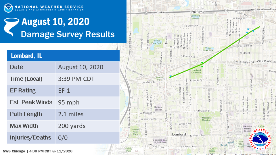
Summary: The same storm which produced the brief Wheaton tornado produced another region of tornado damage immediately east of I-355 just east of Lilacia Park in Lombard. This tornado also continued in a northeasterly direction, uprooting trees -- some snapped at the trunk, and causing damage to some houses -- a few of which sustained substantial roof damage. The worst damage occurred near and around the Lombard Common just south of St. Charles Road. Damage eased considerably on the north side of the circulation, with a more gradual drop off in damage to its south. The tornado lifted just northeast of the Jefferson Middle School. |
|
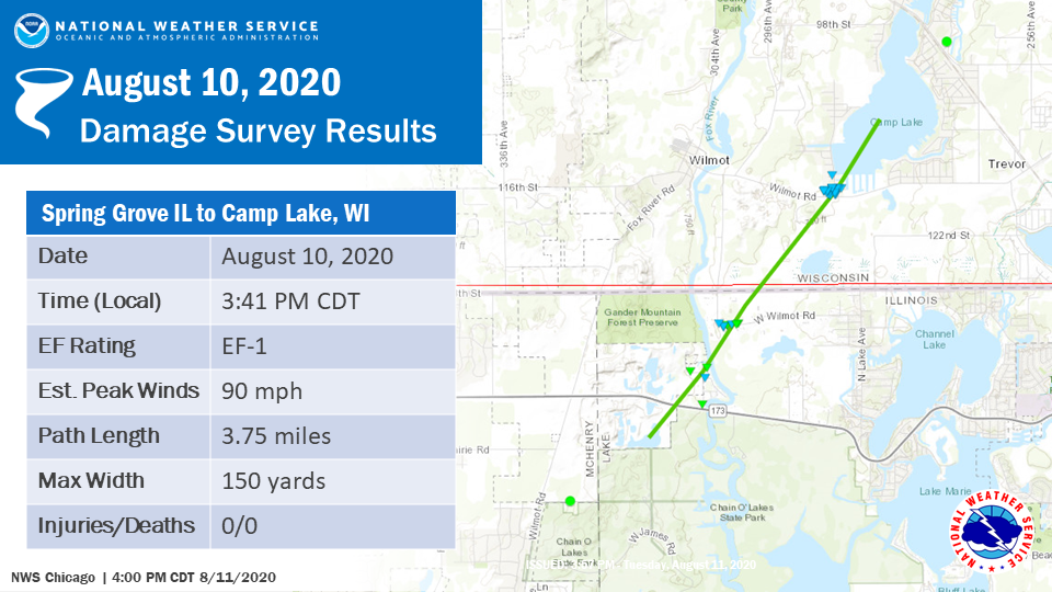
Tornado #10 - Spring Grove, IL to Camp Lake, WI EF-1
Summary: This tornado started in northwest Lake County, continued into Wisconsin and through Camp Lake, and appeared to dissipate over the lake in NWS Milwaukee's area of responsibility. Mainly tree damage occurred, with the most significant structural damage occurring in northwestern Lake County. |
|
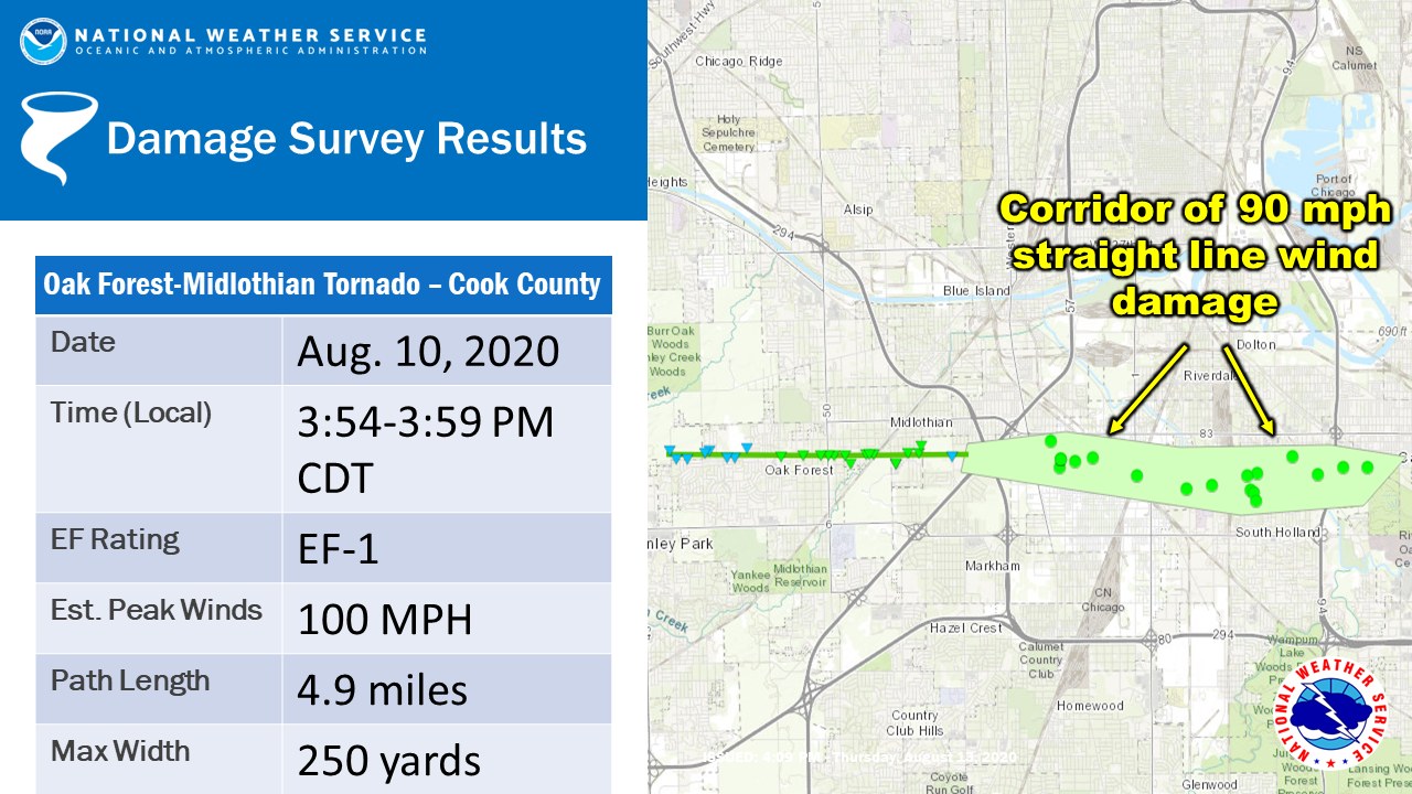
Tornado #11 - Oak Forest to Midlothian, IL EF-1
Summary: A tornado touched down just east of South Harlem Avenue in Oak Forest, then moved nearly due east along 151st Street, producing mainly minor tree and structural damage before lifting near the I-57/I-294 interchange in Midlothian. The worst and most concentrated damage then occurred near Midlothian in the region between Cicero Avenue and Pulaski Road. Several large trees and power poles were snapped near their bases in this region, producing damage consistent with an EF-1 tornado. Damage felled consistently in a convergent pattern towards the track centerline. The tornado damage then began to transition to a region of enhanced straight-line winds near the I-57/294 interchange, where the damage became increasingly oriented in an easterly direction. Downed utility poles and snapped trees indicate wind speeds were likely near 90 mph, with the most notable damage centered in and around the Harvey area bounded on the north by Sibley Boulevard and the south by 159th Street. This high degree of wind damage persisted east into the Shabbona Woods Forest Preserve before easing towards Calumet City. |
|
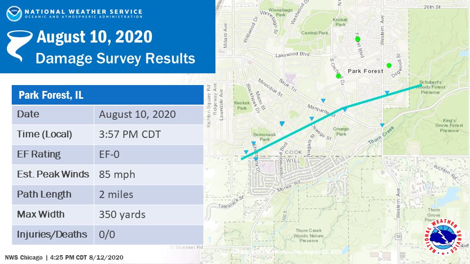
Tornado #12 - Park Forest, IL EF-0
Summary: A brief tornado touched down very close to the Cook/Will county line near Shabbona Drive. It tracked northeast, where it produced a localized area of tree damage consistent with high-end EF-0 wind speeds. The worst damage was confined to a small area near Marquette and Somonauk Parks, although very little structural damage was noted in this area. The tornado lifted over Schubert's Woods Forest Preserve. Sporadic straight-line wind damage continued east towards State Street east of South Chicago Heights. |
|
Tornado #13 - Lincolnwood to Rogers Park - Chicago, IL EF-1
Summary: This tornado initially touched down south of the intersection of Crawford and Touhy Avenues in the suburb of Lincolnwood. It then continued moving just north of due east before moving offshore near the Jarvis and Fargo beaches. The most intense damage, consistent with that of a high-end EF-1 tornado, occurred within approximately one mile of the lakefront, as well as near and within Phillip Rogers Park. |
|
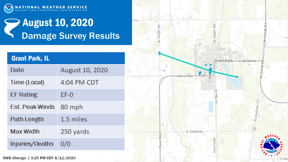
Tornado #14 - Grant Park, IL
Summary: An EF-0 tornado touched down just northwest of Grant Park along N 11000 E Road and traveled southeast through Grant Park. Considerable tree damage was found along the path. The tornado ended near Lake Metonga. |
|
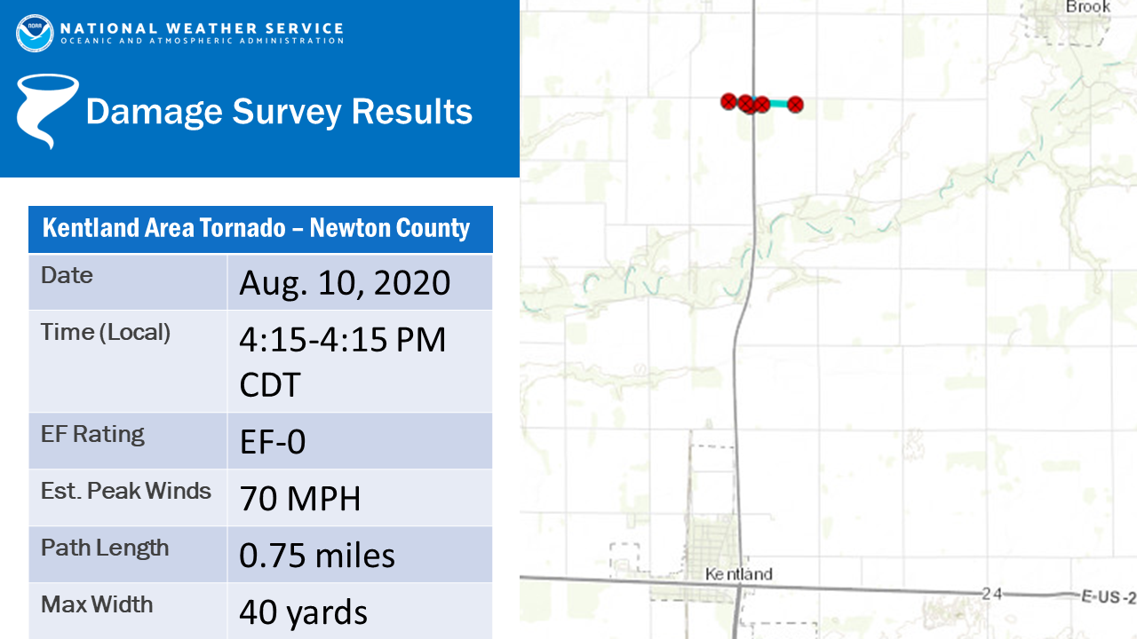
Tornado #15 - Kentland, IN Area
Summary: This brief EF-0 tornado was on the ground for less than 1 minute and produced minor damage to a metal farm building immediately west of State Highway 41. |
The Enhanced Fujita (EF) Scale classifies tornadoes into the following categories:
| EF0 Weak 65-85 mph |
EF1 Moderate 86-110 mph |
EF2 Significant 111-135 mph |
EF3 Severe 136-165 mph |
EF4 Extreme 166-200 mph |
EF5 Catastrophic 200+ mph |
 |
|||||
Radar:
Loops
 |
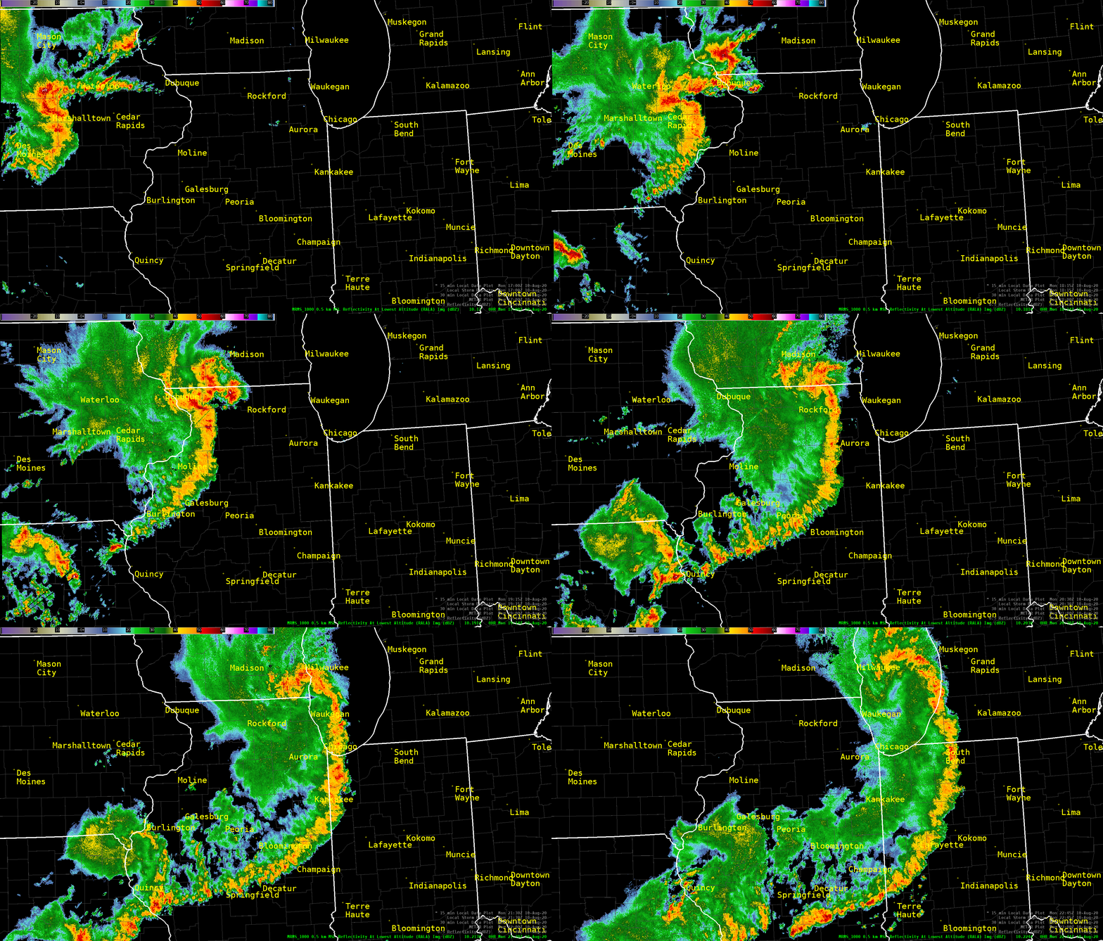 |
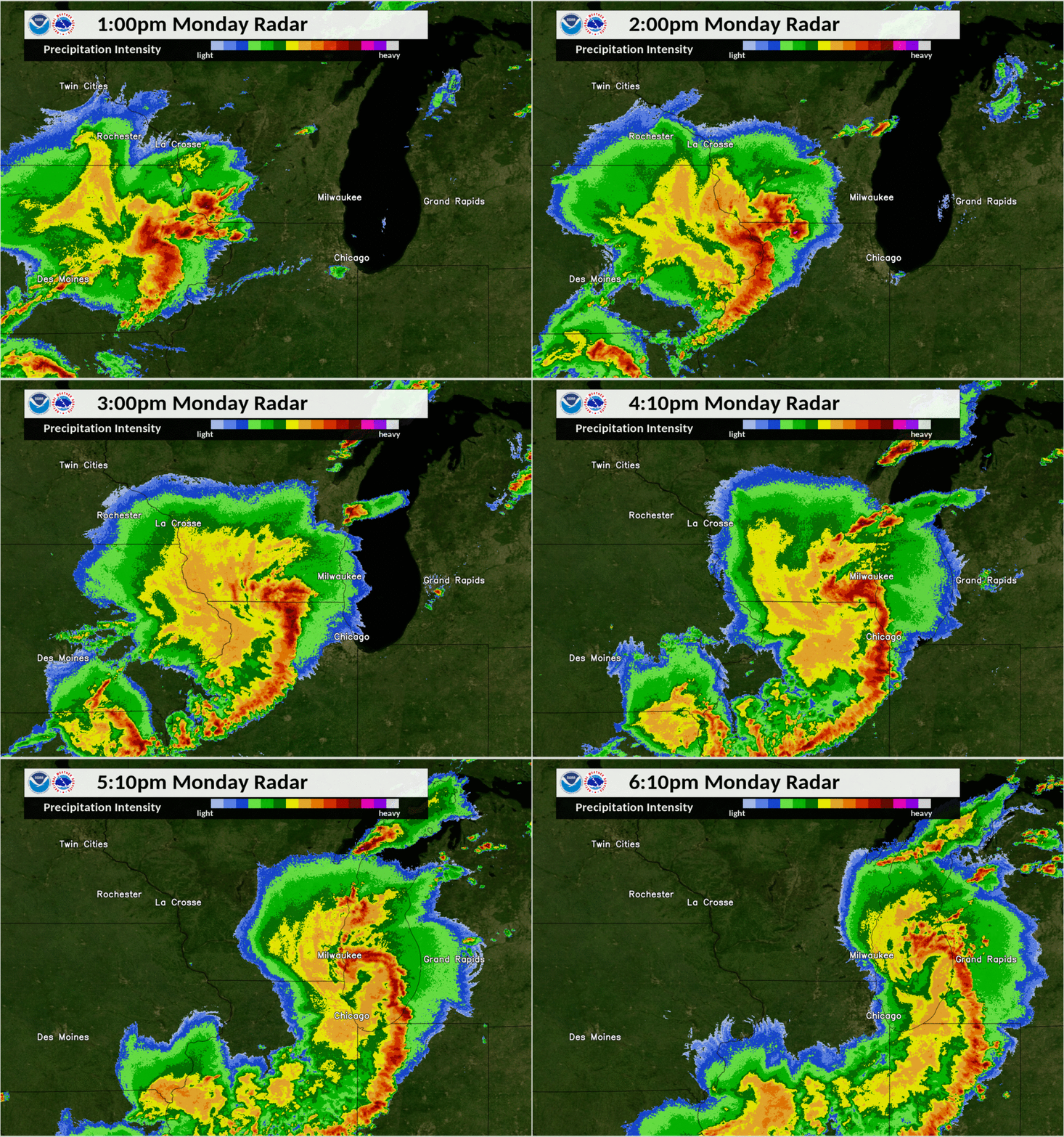
| Composite radar (highest intensity within the column) of the derecho across northern Illinois courtesy of NWS Milwaukee. | Lowest level radar scans of the derecho across northern Illinois. |
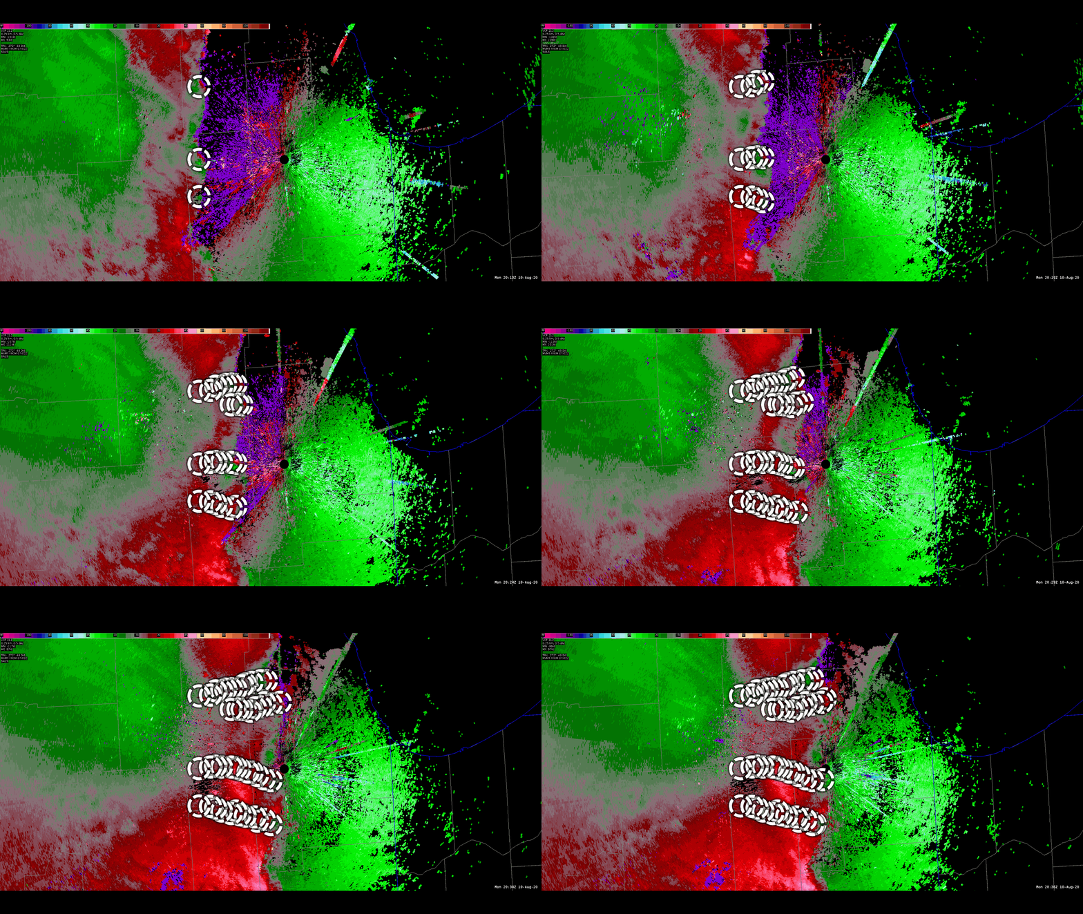 |
| Storm-Relative Velocity from KLOT between 3:13 and 3:36 PM CDT with circulation tracks circled and overlaid. The circulations embedded within the line were responsible for the "fingers" of damage across the Chicago Area, within which brief tornadoes were common. |
Photos:
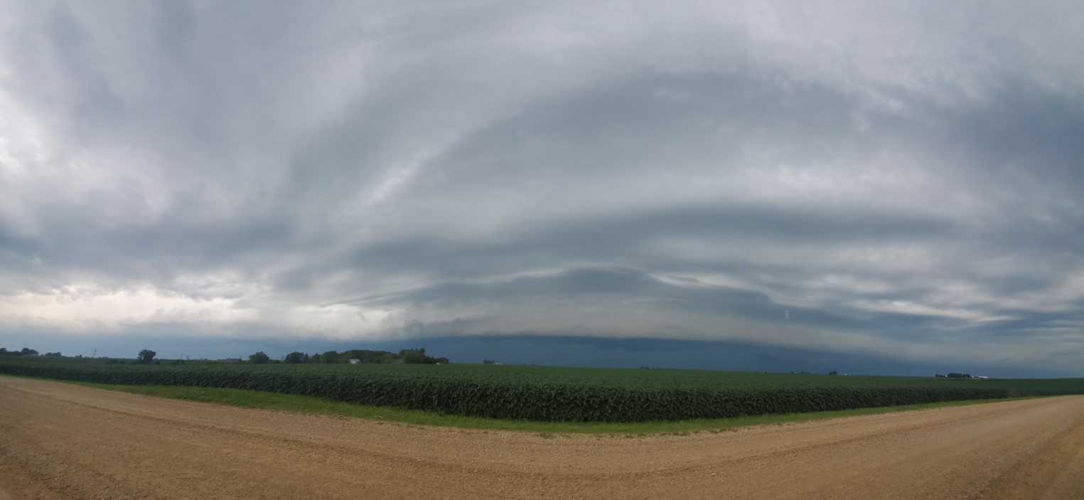
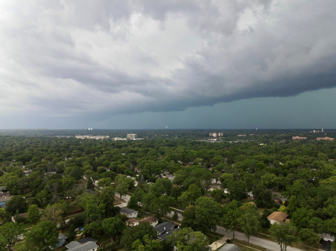
Approaching Derecho
 |
 |
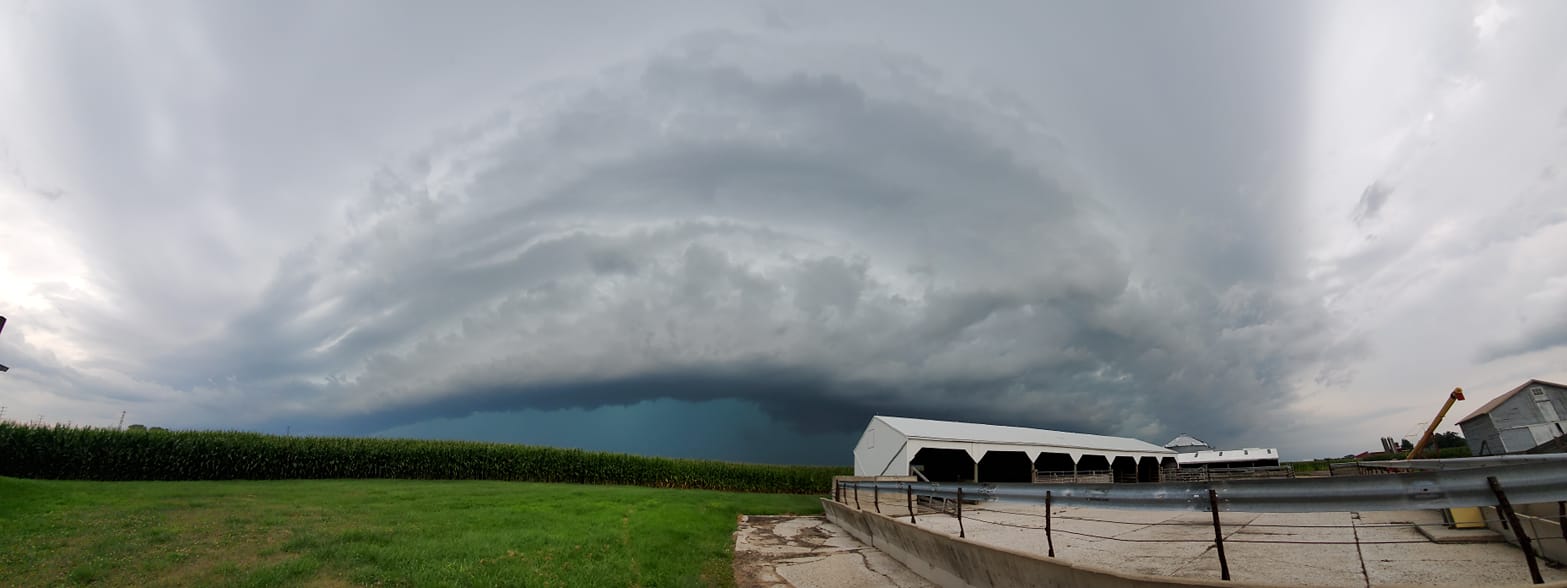 |
| Shelf cloud 2 miles west of Mendota, IL courtesy of Heather Friedlein | Shelf cloud near Lisle, IL courtesy of Keith Langosch | Shelf cloud from near Sugar Grove, IL courtesy of Maddie Murphy. |
Tornadoes
 |
| Ottawa, IL tornado courtesy of Jason Ward. |
Storm Damage
 |
 |
 |
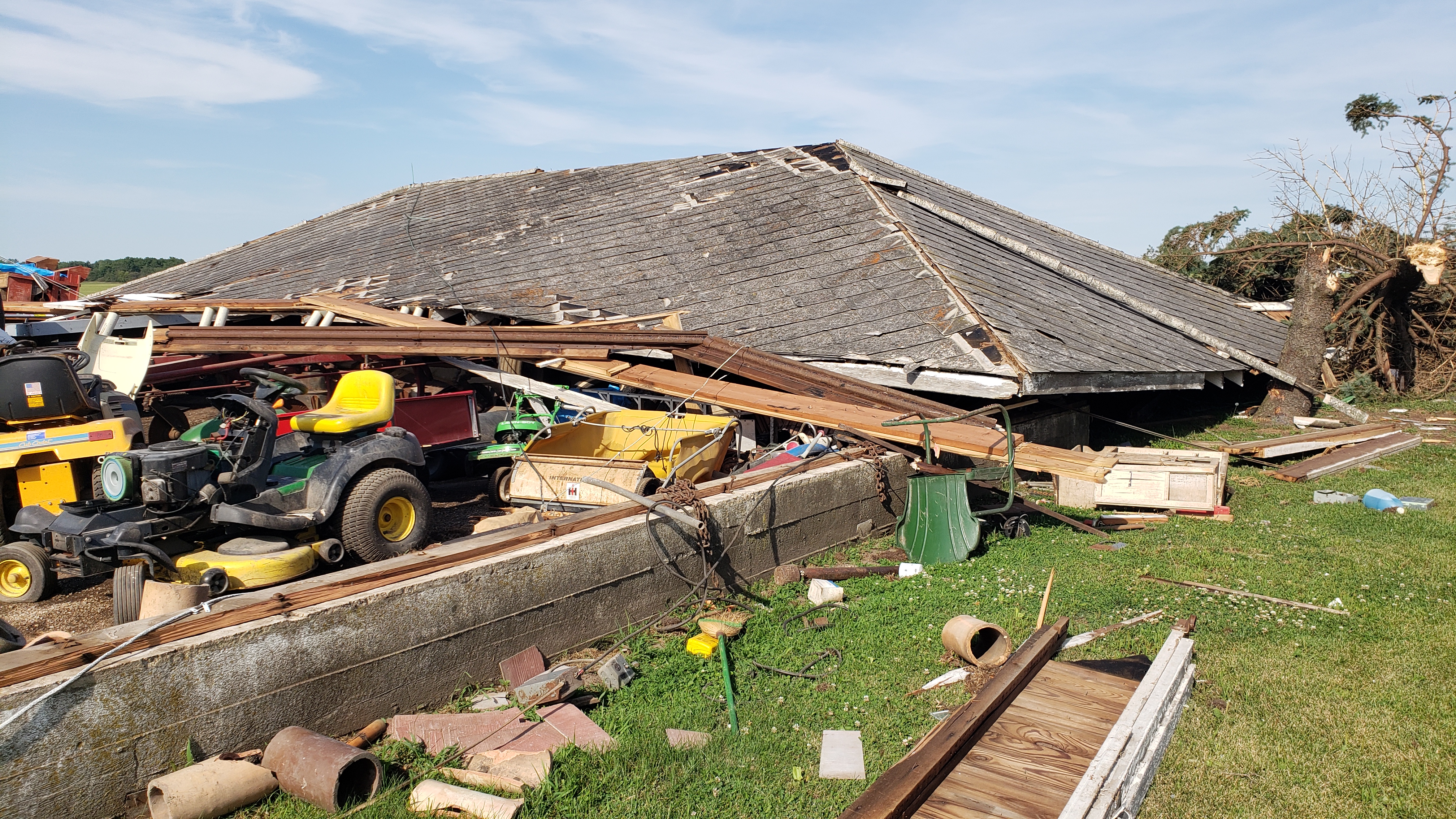 |
| Kendall County to Will County tornado - NWS Survey | Kendall County to Will County tornado - NWS Survey | Kendall County to Will County tornado - NWS Survey | Kendall County to Will County tornado - NWS Survey |
 |
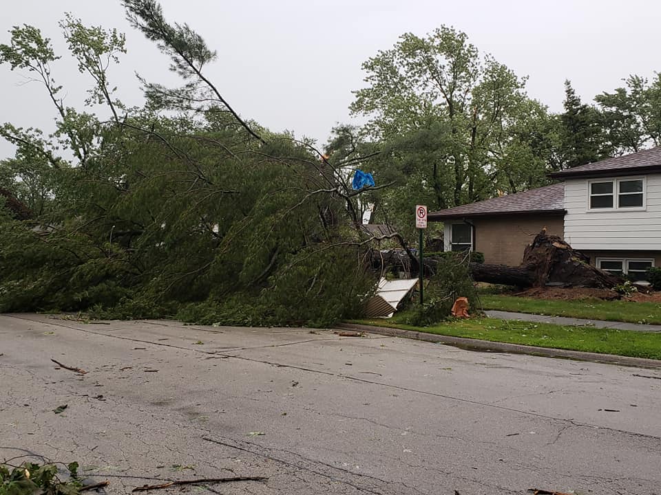 |
| Elburn, IL, courtesy of Matt Taylor | Midlothian, IL, courtesy of Matt Kooi |
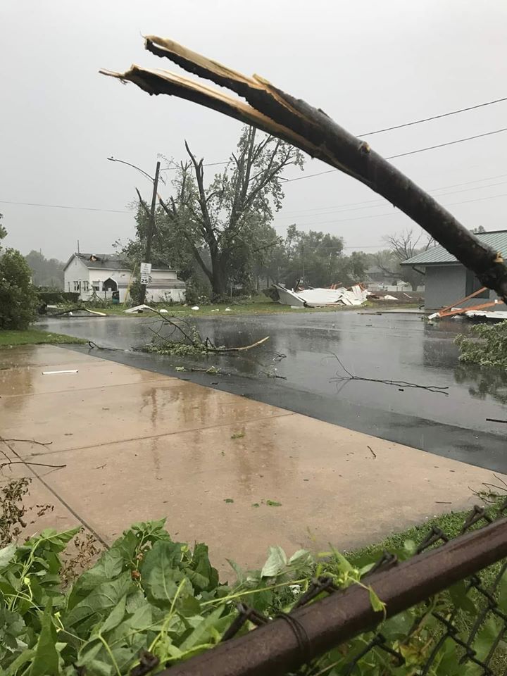 |
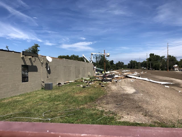 |
 |
| Ottawa, IL courtesy of Matthew Spika | Ottawa, IL courtesy of Gilbert Sebenste | Wheaton, IL church steeple damage courtesy of Carrie Vicek-Jodelka |
 |
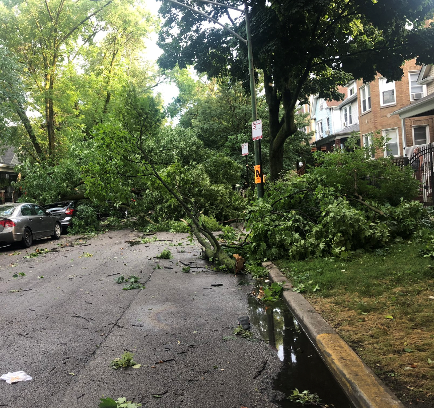 |
 |
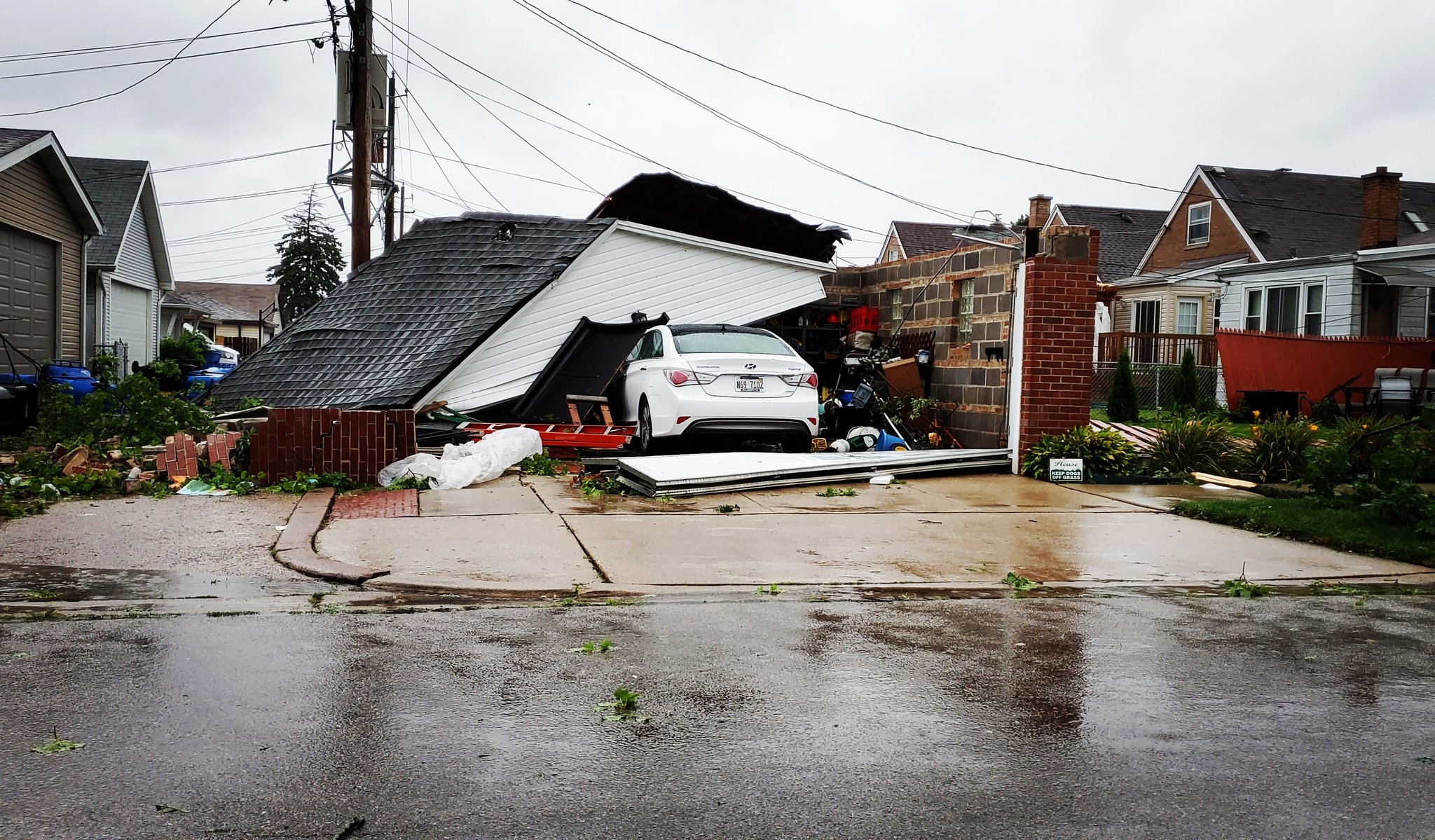 |
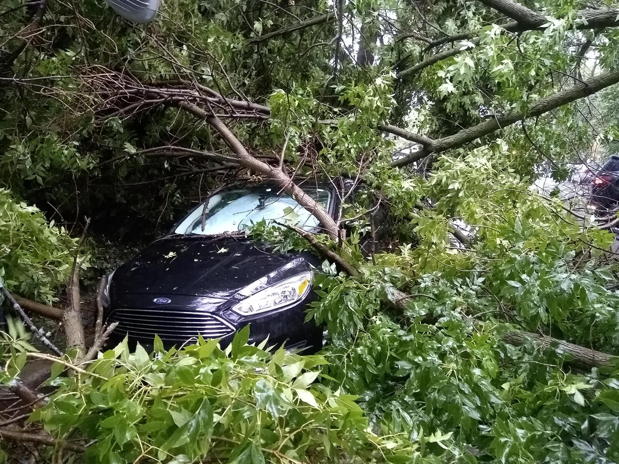
| Somonauk, IL courtesy of Bob Waszak | Chicago, Albany Park community area, courtesy of Alex Forgue | Chicago, Rogers Park community area, courtesy of Paul Navarro | Chicago, Dunning community area, courtesy of Twitter follower @Jasong1451 |
 |
 |
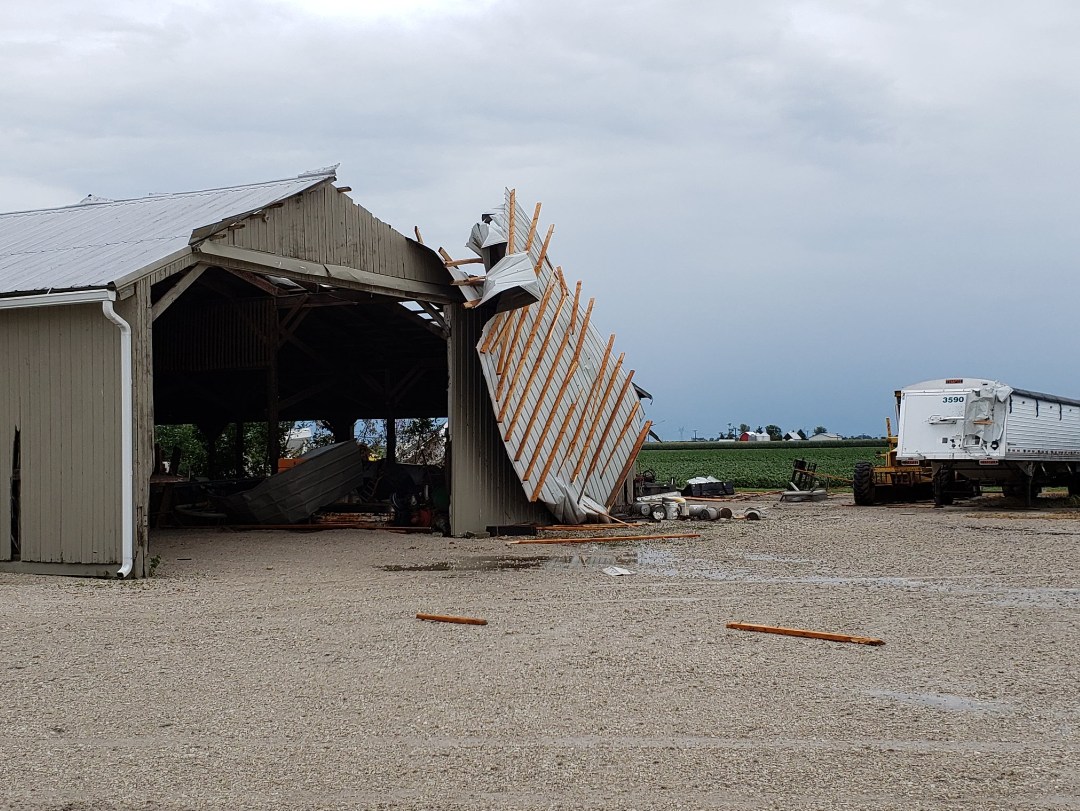 |
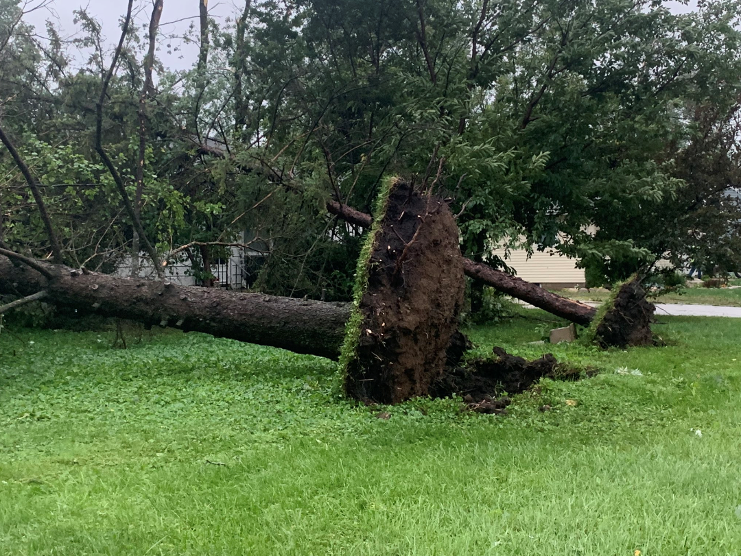
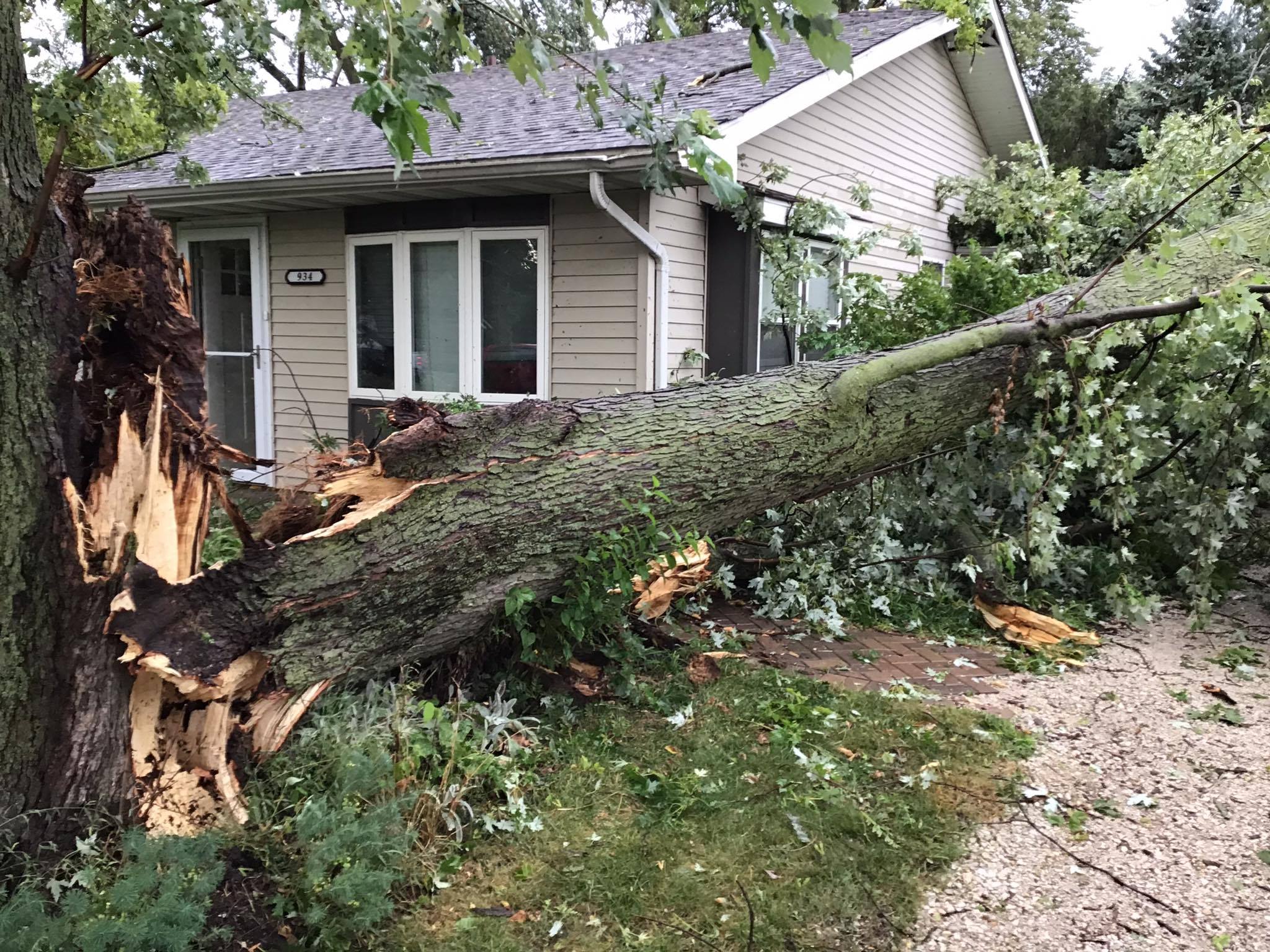
| New Lenox, IL courtesy of the Joliet Weather Center | New Lenox, IL courtesy of Dan Casper | Dwight, IL courtesy of Andrew Pritchard |
Environment
 |
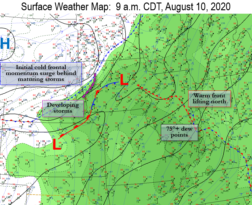 |
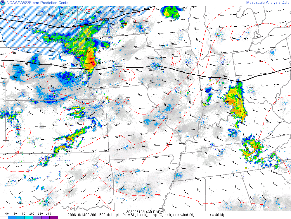
| Aug 10, 9 a.m. 500 mb (~18,000 ft) level, showing a strong short wave and associated 50-70 kt speed maximum moving eastward across the Upper Midwest. This would be a driving force for continued upper support through the thunderstorm complex's lifecycle. | Aug 10, 9 a.m. surface weather map highlighting the very moist air mass ahead of the maturing thunderstorm complex at that time. Note the warm front also slowly moving north. This boundary supported continued low-level warm and moist advection (fuel to the storms), as well as a source for low-level veering profiles near it increasing tornadogenesis potential especially in the toward the IL/WI state line by mid afternoon. |
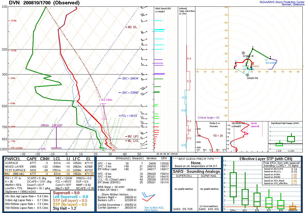 |
| NWS Quad Cities weather balloon launch at 12 p.m. on August 10 that sampled a high amount of instability thanks to exceptionally steep mid-level lapse rates and very high equilibrium levels, ample moisture, and undirectional mid-level flow of sufficient amount for long-lived, organized, forward-propagating storms. |
 |
 |
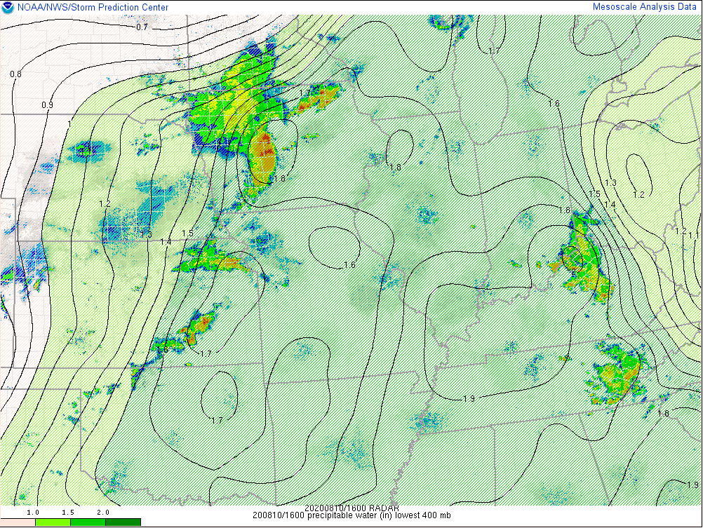 |
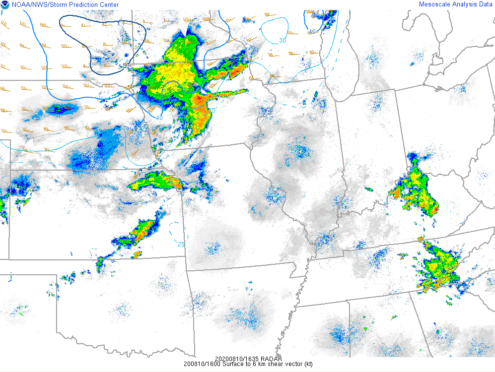
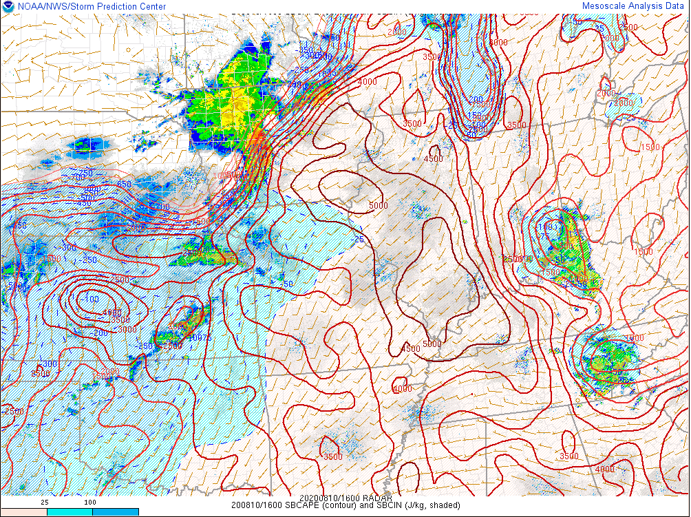
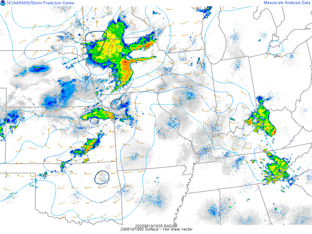
| Aug 10, 11 a.m. deep layer wind shear, with values of 40+ kt sufficient for storm organization, and given the unidirectional mid-level wind profile, this also would help support the development of a forward-propagating storm complex. | Aug 10, 11 a.m. surface-based CAPE (instability), with widespread values over 2,500 J/kg indicating a strongly unstable air mass ahead of the incoming thunderstorm complex. | Aug 10, 11 a.m. precipitable water, with an ample moisture reservoir present for the replenishing of moisture into the thunderstorm complex. |
 |
 |
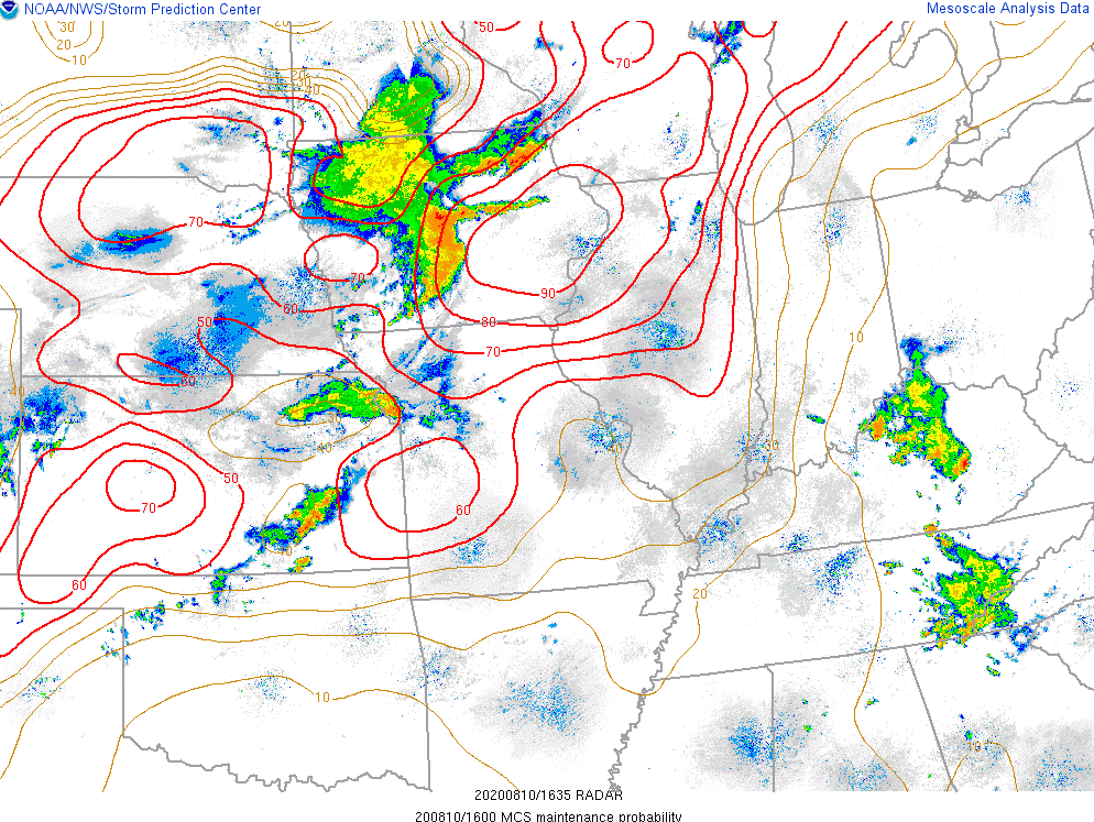 |
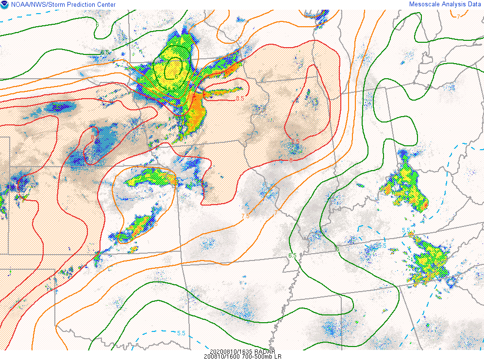
| Aug 10, 11 a.m. mid-level lapse rates with 8C/km or higher through that layer reflecting the potential for rapidly accelerating updrafts. Combined with sufficient low-level moisture and heating, this indicates explosive convection processes. | Aug 10, 11 a.m. low-level wind shear with values of 20-25 kt (that likely increased further as the complex strengthened) indicating cold pool organization from rain-cooled air. A cold pool allows for stronger storm forward motion and wind momentum given the other ingredients. Also, these values are sufficient enough for tornado potential if defined storm inflow areas that can harness low-level turning were to develop. | Aug 10, 11 a.m. MCS maintenance parameter, which provides probabilistic information combining shear profile data, mid-level lapse rates, instability, and mid and upper level wind flow. High probabilities of 90+ percent for ~200 miles ahead of the maturing storm complex are not surprising given the high values of these input parameters. |
 |
 |
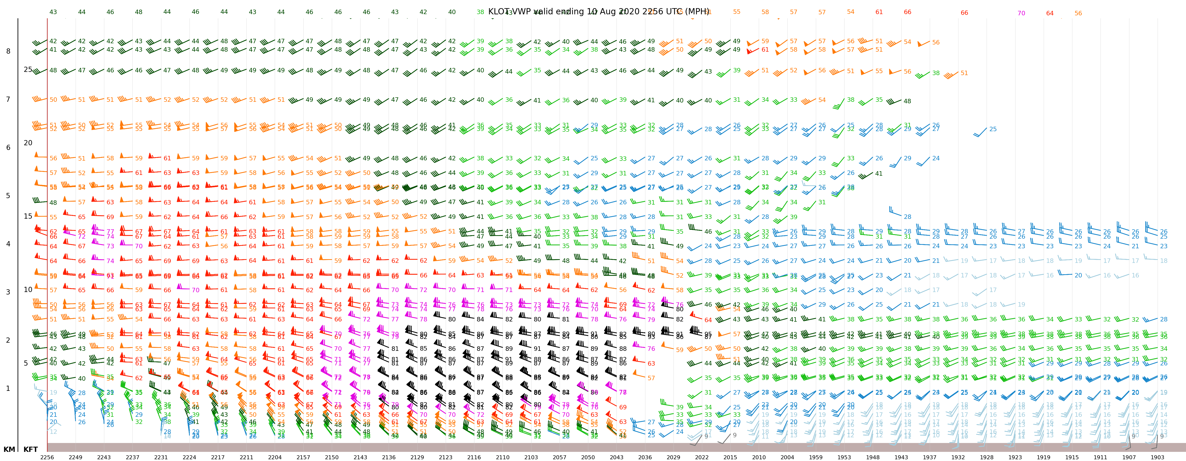 |
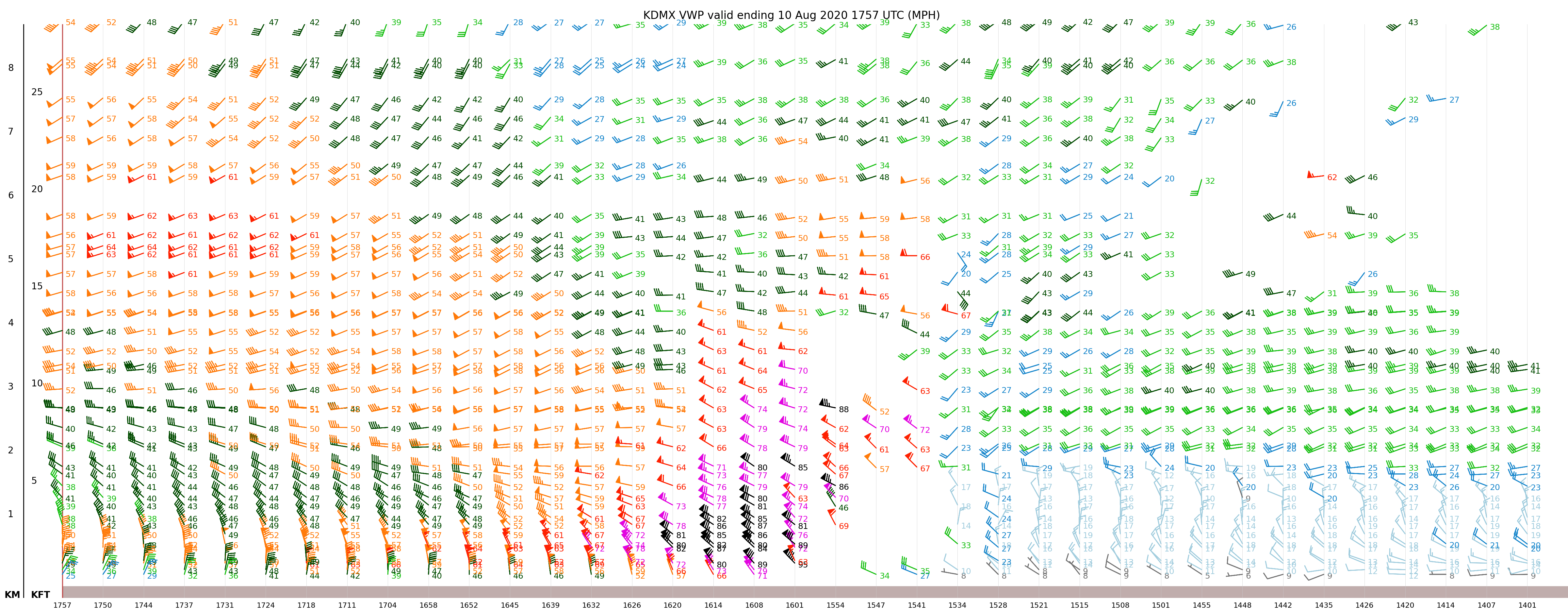
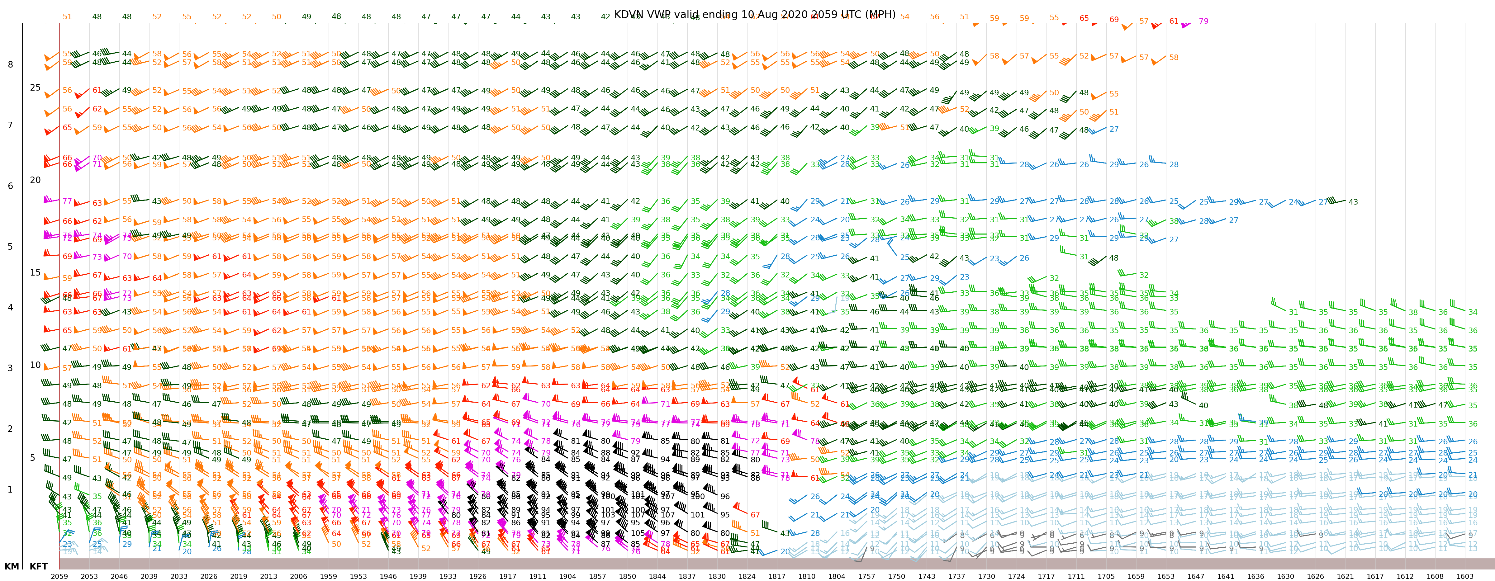
| NWS Des Moines Doppler Radar Vertical Wind Profile data (separate tab for full resolution) | NWS Quad Cities Doppler Radar Vertical Wind Profile data (separate tab for full resolution) | NWS Chicago/Romeoville Doppler Radar Vertical Wind Profile data (separate tab for full resolution) |
| These are basically cross-sections of the derecho's wind profile, namely its rear-inflow jet (RIJ), as the system moved from west-to-east over the area. The RIJ is most mature as the system moves over the Quad Cities, with impressive 100+ mph winds immediately off the surface (some realized at the surface). Notice the unidirectional northwest flow of the low-level jet, ideal for momentum transfer of the strongest winds to the surface that was realized with frequent severe wind gusts persisting a half hour in places! Also interesting to note is the wind profile immediately ahead of the front edge of the derecho's front edge (i.e. the wind shift). For the NWS Chicago profile data, there is more low-level shear (~0-1.5 km) in that immediate pre-storm environment which may explain the tendency for more mesovortices and, in turn, corridors of enhanced wind damage and tornadoes in our area vs. further west. | ||
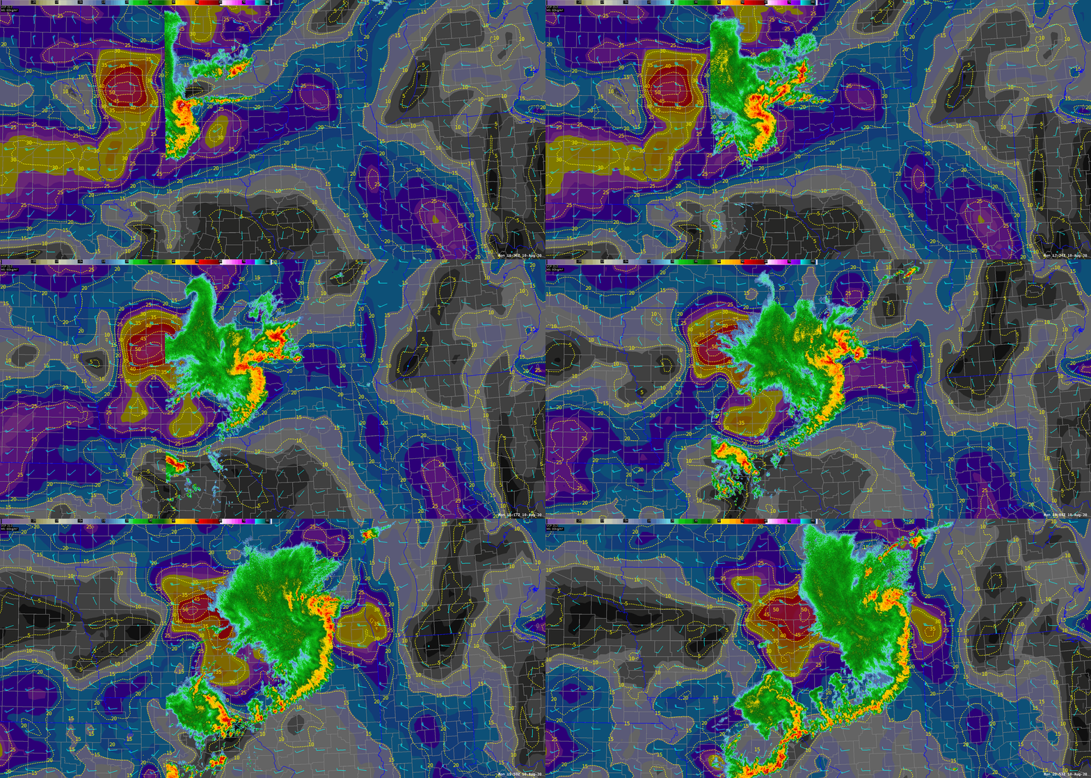 |
| Loop of MRMS regional reflectivity and RAP 0-2 km shear (shaded, barbs, and contours), showing the rapid increase in low-level shear as the derecho moved into northern Illinois. The increase in shear is thought to have influenced the development of mesovortices and efficient tornado production in northern Illinois and northwestern Indiana. |
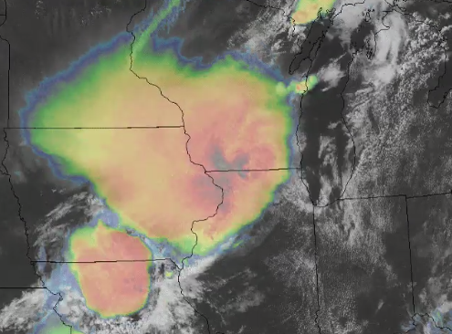 |
| Click image for 14-hour satellite loop of the derecho shared on Twitter. |
Rain Reports
Public Information Statement
National Weather Service Chicago IL
1103 PM CDT Tue Aug 11 2020 /1203 AM EDT Wed Aug 12 2020/

...Rainfall from Monday August 10th...

The following are rainfall amounts as measured in the morning by
NWS Cooperative observers and CoCoRaHS observers. Observations are
usually taken at 7 AM.

ILLINOIS                                     Rainfall
  Location (County):                         Amt(inches)

  South Beloit 2SE (Winnebago).................2.66
  Roscoe 2se (Winnebago).......................2.48
  Roscoe 2ESE (Winnebago)......................2.48
  Capron (Boone)...............................2.46
  Rockford 2ENE (Winnebago)....................1.30
  Hebron (McHenry).............................1.22
  Lake Villa 1SSW (Lake).......................1.00
  Woodstock 5nw (McHenry)......................0.98
  Brandon Road Lock & Dam (Will)...............0.94
  Lake Villa 2WSW (Lake).......................0.92
  Gurnee 2W (Lake).............................0.91
  Woodstock 4SW (McHenry)......................0.87
  Oregon (Ogle)................................0.85
  Bull Valley 2WNW (McHenry)...................0.83
  Kingston 2WNW (De Kalb)......................0.82
  New Lenox 3ENE (Will)........................0.75
  Morris 6ESE (Grundy).........................0.75
  McHenry (Stratton Lock & Dam) (McHenry)......0.74
  Winthrop Harbor (Lake).......................0.74
  New Lenox 3E (Will)..........................0.73
  Mokena 1W (Will).............................0.73
  Woodstock 1SSW (McHenry).....................0.73
  Lakemoor 2NW (McHenry).......................0.73
  Channahon 2SSE (Will)........................0.72
  Winthrop Harbor 1SSW (Lake)..................0.72
  Midlothian (Cook)............................0.72
  Carbon Hill 3.1N (Grundy)....................0.71
  Genoa (De Kalb)..............................0.71
  Coal City 4NNW (Grundy)......................0.71
  Beecher 3ENE (Will)..........................0.70
  Glen Ellyn 2SSE (Du Page)....................0.70
  Bourbonnais (Kankakee).......................0.70
  Plainfield 2SSE (Will).......................0.69
  Lake Forest 2NNE (Lake)......................0.69
  Manhattan 2SE (Will).........................0.68
  Round Lake 2WNW (Lake).......................0.68
  Elwood 5NE (Will)............................0.67
  Lockport 1SE (Will)..........................0.66
  Plainfield 3ESE (Will).......................0.66
  Aurora 4SE (Du Page).........................0.66
  Oak Park 2S (Cook)...........................0.66
  Elmhurst 1ESE (Du Page)......................0.64
  Wilmington 6NW (Will)........................0.63
  Naperville 4SSW (Will).......................0.63
  Wilmington 3SE (Will)........................0.63
  Morris 2SSE (Grundy).........................0.63
  Aurora 4SE (Du Page).........................0.63
  La Grange Park 1SSW (Cook)...................0.63
  Crystal Lake 1WSW (McHenry)..................0.62
  La Salle (La Salle)..........................0.62
  Naperville 2SE (Du Page).....................0.62
  Oak Park 1SW (Cook)..........................0.62
  Oak Lawn 2SE (Cook)..........................0.62
  DeKalb (De Kalb).............................0.62
  Joliet 2n (Will).............................0.61
  Crete 3E (Will)..............................0.61
  Plano (Kendall)..............................0.61
  Huntley (McHenry)............................0.59
  Naperville 2ESE (Du Page)....................0.59
  Peru 1ENE (La Salle).........................0.58
  De Kalb 1SW (De Kalb)........................0.58
  Oswego 5SSE (Kendall)........................0.57
  Waukegan (Lake)..............................0.56
  Steward (Lee)................................0.56
  Pontiac (Livingston).........................0.56
  Algonquin 1N (McHenry).......................0.56
  Beecher 3SSE (Will)..........................0.55
  Westmont 1SSW (Du Page)......................0.55
  Oak Forest 1SSE (Cook).......................0.55
  Joliet 3WNW (Will)...........................0.54
  Cary (McHenry)...............................0.54
  Emington 2SSE (Livingston)...................0.54
  Somonauk 2NE (De Kalb).......................0.54
  Naperville 2ESE (Du Page)....................0.53
  Seneca 1NNE (La Salle).......................0.52
  Gilberts (Kane)..............................0.52
  Cortland (De Kalb)...........................0.52
  Glen Ellyn (Du Page).........................0.52
  Lisle Morton Arb (Du Page)...................0.51
  Rockford (Winnebago).........................0.51
  Peru 1SW (La Salle)..........................0.51
  Gibson 3WNW (Ford)...........................0.51
  Elmhurst 2SE (Du Page).......................0.51
  Oak Lawn (Cook)..............................0.51
  Morris (Grundy)..............................0.50
  Elgin (Kane).................................0.50
  Park Forest 1NNE (Cook)......................0.49
  Rogers Park 2SW (Cook).......................0.49
  Chicago Ridge (Cook).........................0.49
  Waukegan 2N (Lake)...........................0.48
  Dixon 3NNW (Lee).............................0.48
  Elgin 2W (Kane)..............................0.48
  Coal City 3N (Grundy)........................0.48
  Homewood (Cook)..............................0.48
  Park Forest (Cook)...........................0.47
  Paw Paw (Lee)................................0.47
  Watseka 6.9WNW (Iroquois)....................0.47
  Morris 5NNW (Grundy).........................0.47
  Naperville 1NW (Du Page).....................0.47
  Westmont (Du Page)...........................0.46
  Mundelein (Lake).............................0.46
  Elgin 2WNW (Kane)............................0.46
  Glencoe (Cook)...............................0.46
  Winnetka 1ESE (Cook).........................0.46
  Aurora (Kane)................................0.46
  Romeoville (Will)............................0.45
  Lake Zurich 1N (Lake)........................0.45
  Riverwoods (Lake)............................0.44
  Ashton (Lee).................................0.44
  Sugar Grove 1NE (Kane).......................0.44
  Buckley (Iroquois)...........................0.44
  Ashkum 5.6E (Iroquois).......................0.44
  Bolingbrook 3NE (Du Page)....................0.44
  Peotone (Will)...............................0.43
  Channahon 1NNE (Will)........................0.43
  Peotone (Will)...............................0.43
  Sugar Grove 1ENE (Kane)......................0.43
  Morris (Grundy)..............................0.43
  Lansing (Cook)...............................0.42
  Mendota (La Salle)...........................0.42
  Geneva 1SSW (Kane)...........................0.42
  Lincolnwood 2E (Cook)........................0.42
  O`hare Airport (Cook)........................0.41
  Mendota (La Salle)...........................0.41
  Mundelein (Lake).............................0.41
  Batavia 1WNW (Kane)..........................0.41
  Batavia 1WSW (Kane)..........................0.40
  Minooka (Grundy).............................0.40
  Elk Grove Village 2WSW (Cook)................0.40
  Lemont (Cook)................................0.40
  Chatsworth (Livingston)......................0.40
  Bannockburn (Lake)...........................0.39
  North Aurora 2NE (Kane)......................0.39
  Geneva 4WSW (Kane)...........................0.39
  Montgomery 1SSE (Kendall)....................0.39
  Lisle (Du Page)..............................0.39
  Highwood 1S (Lake)...........................0.38
  Batavia 2WNW (Kane)..........................0.38
  Lisle 1SE (Du Page)..........................0.38
  Oak Park 1NNE (Cook).........................0.38
  Oak Lawn 1N (Cook)...........................0.38
  Roselle 1ESE (Du Page).......................0.37
  Dwight (Livingston)..........................0.37
  Homer Glen 1ENE (Will).......................0.36
  Pontiac 1SE (Livingston).....................0.36
  North Utica 6N (La Salle)....................0.36
  Libertyville 2ESE (Lake).....................0.36
  Darien (Du Page).............................0.36
  Earlville 5NNE (De Kalb).....................0.36
  Mount Prospect 3NE (Cook)....................0.36
  Batavia (Kane)...............................0.36
  Paxton (Ford)................................0.35
  Ottawa 2N (La Salle).........................0.35
  Lake Bluff 1W (Lake).........................0.35
  St. Charles 6NW (Kane).......................0.35
  St. Charles (Kane)...........................0.35
  Midway Coop (Cook)...........................0.34
  Lisle 1SW (Du Page)..........................0.34
  Palatine 1NNE (Cook).........................0.34
  Lake Zurich (Lake)...........................0.33
  Buffalo Grove 2N (Lake)......................0.33
  Herscher 3E (Kankakee).......................0.33
  Plainfield 5SW (Kendall).....................0.33
  Earlville 3S (La Salle)......................0.33
  Schaumburg (Du Page).........................0.33
  Wheeling (Cook)..............................0.32
  Midway (Cook)................................0.32
  Coal City (Grundy)...........................0.32
  Gibson 6NE (Ford)............................0.32
  Burr Ridge 2SW (Du Page).....................0.32
  Bartlett 1SE (Du Page).......................0.32
  Wheaton 2NNE (Du Page).......................0.31
  Elk Grove Village 1ESE (Cook)................0.31
  Elmwood Park 1ESE (Cook).....................0.31
  West Chicago (Du Page).......................0.31
  Ottawa (La Salle)............................0.30
  Lombard 1NNW (Du Page).......................0.30
  Elmhurst (Du Page)...........................0.30
  Marseilles 5WNW (La Salle)...................0.29
  Arlington Heights 1S (Cook)..................0.28
  Hoffman Estates 5W (Cook)....................0.28
  Lincolnshire 1N (Lake).......................0.27
  Harwood Heights (Cook).......................0.27
  Ottawa 1NW (La Salle)........................0.25
  Palos Park 1SW (Cook)........................0.25
  St Anne (Kankakee)...........................0.24
  Paxton (Ford)................................0.24
  Bridgeview 1NNW (Cook).......................0.24
  Ottawa (La Salle)............................0.23
  Schaumburg 2E (Cook).........................0.23
  Cissna Park 1S (Iroquois)....................0.22
  Park Ridge (Cook)............................0.22
  Cropsey 1NE (Livingston).....................0.21
  Hoffman Estates 2SE (Cook)...................0.21
  Park Ridge 1WNW (Cook).......................0.20
  Streator (Livingston)........................0.18

INDIANA                                      Rainfall
  Location (County):                         Amt(inches)

  Hebron 1NW (Porter)..........................1.34
  Hebron 3SW (Lake)............................1.24
  Remington (Jasper)...........................1.15
  Lakes Of The Four Seasons (Porter)...........0.94
  Wheatfield 5W (Jasper).......................0.94
  Wheatfield 3S (Jasper).......................0.88
  Rensselaer 5NW (Jasper)......................0.84
  Mount Ayr 2NNE (Newton)......................0.80
  Hebron 4NE (Porter)..........................0.74
  Rensselaer (Jasper)..........................0.70
  Rensselaer 2N (Jasper).......................0.69
  De Motte 1NNW (Jasper).......................0.69
  Rensselaer 2SSW (Jasper).....................0.69
  Crown Point (Lake)...........................0.68
  Crown Point 1N (Lake)........................0.67
  Rensselaer 4N (Jasper).......................0.64
  De Motte 1SW (Jasper)........................0.64
  De Motte 6S (Jasper).........................0.64
  De Motte 1SSW (Jasper).......................0.62
  Rensselaer 10NNE (Jasper)....................0.61
  Wheatfield 4WSW (Jasper).....................0.59
  Rensselaer 8ENE (Jasper).....................0.59
  Porter 1S (Porter)...........................0.54
  Valparaiso 4SW (Porter)......................0.50
  Valparaiso 2N (Porter).......................0.49
  Portage 3E (Porter)..........................0.48
  Hammond 1SSW (Lake)..........................0.46
  Valparaiso 2NW (Porter)......................0.43
  Chesterton 1ENE (Porter).....................0.42
  Kentland 2SSE (Newton).......................0.42
  Rensselaer 6SE (Jasper)......................0.41
  Indiana Dunes (Porter).......................0.41
  Schererville 2ESE (Lake).....................0.38
  Hobart 2E (Lake).............................0.37
  Hobart 1SSW (Lake)...........................0.36
  Kentland (Newton)............................0.35
  Chesterton 4E (Porter).......................0.34
  Gary 5ENE (Lake).............................0.33
  Valparaiso 6SSW (Porter).....................0.30
  Schererville 1E (Lake).......................0.29
  Munster 2NNW (Lake)..........................0.27
  Schererville 1E (Lake).......................0.27
  Griffith 1N (Lake)...........................0.26
  St. John (Lake)..............................0.25
  Dyer 1WNW (Lake).............................0.23
Other NWS Office Recaps
 |
Media use of NWS Web News Stories is encouraged! Please acknowledge the NWS as the source of any news information accessed from this site. Additional recaps can be found on the NWS Chicago Past Events Page |
|




.PNG)
 Follow us on X
 Follow us on Facebook
 Follow us on YouTube
 LOT RSS Feed