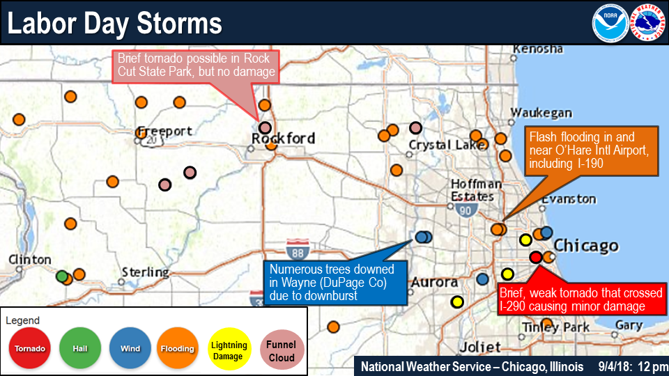
Flash flooding threatens areas from the Tennessee Valley to the Carolinas as storms repeat along a stalled front. Monsoonal storms may trigger flooding in the Southwest. Dangerous heat expands across the Desert Southwest, Plains, mid-Mississippi Valley and Southern Tier. Critical fire weather for interior Pacific Northwest. Cooler, drier air brings brief relief to the Great Lakes and Northeast. Read More >
Overview
|
Fast Facts:
|
 Overview |
Tornadoes:
|
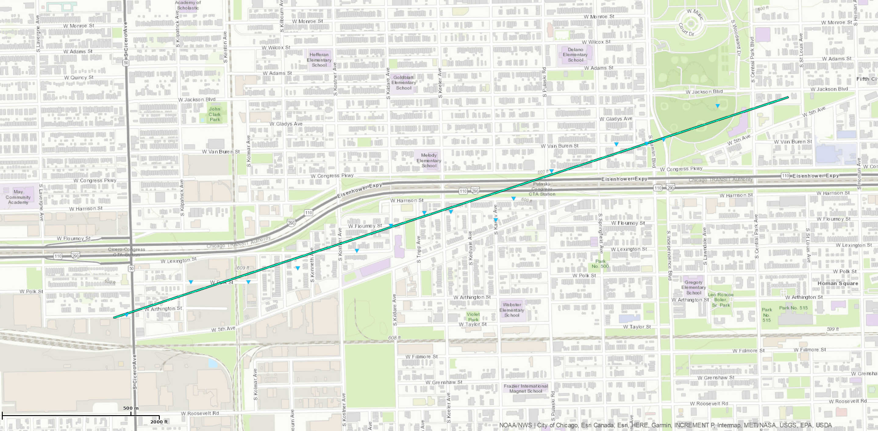
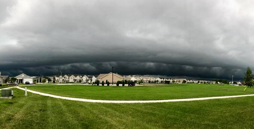
Tornado - WEST SIDE OF CHICAGO
|
||||||||||||||||
The Enhanced Fujita (EF) Scale classifies tornadoes into the following categories:
| EF0 Weak 65-85 mph |
EF1 Moderate 86-110 mph |
EF2 Significant 111-135 mph |
EF3 Severe 136-165 mph |
EF4 Extreme 166-200 mph |
EF5 Catastrophic 200+ mph |
 |
|||||
Photos:
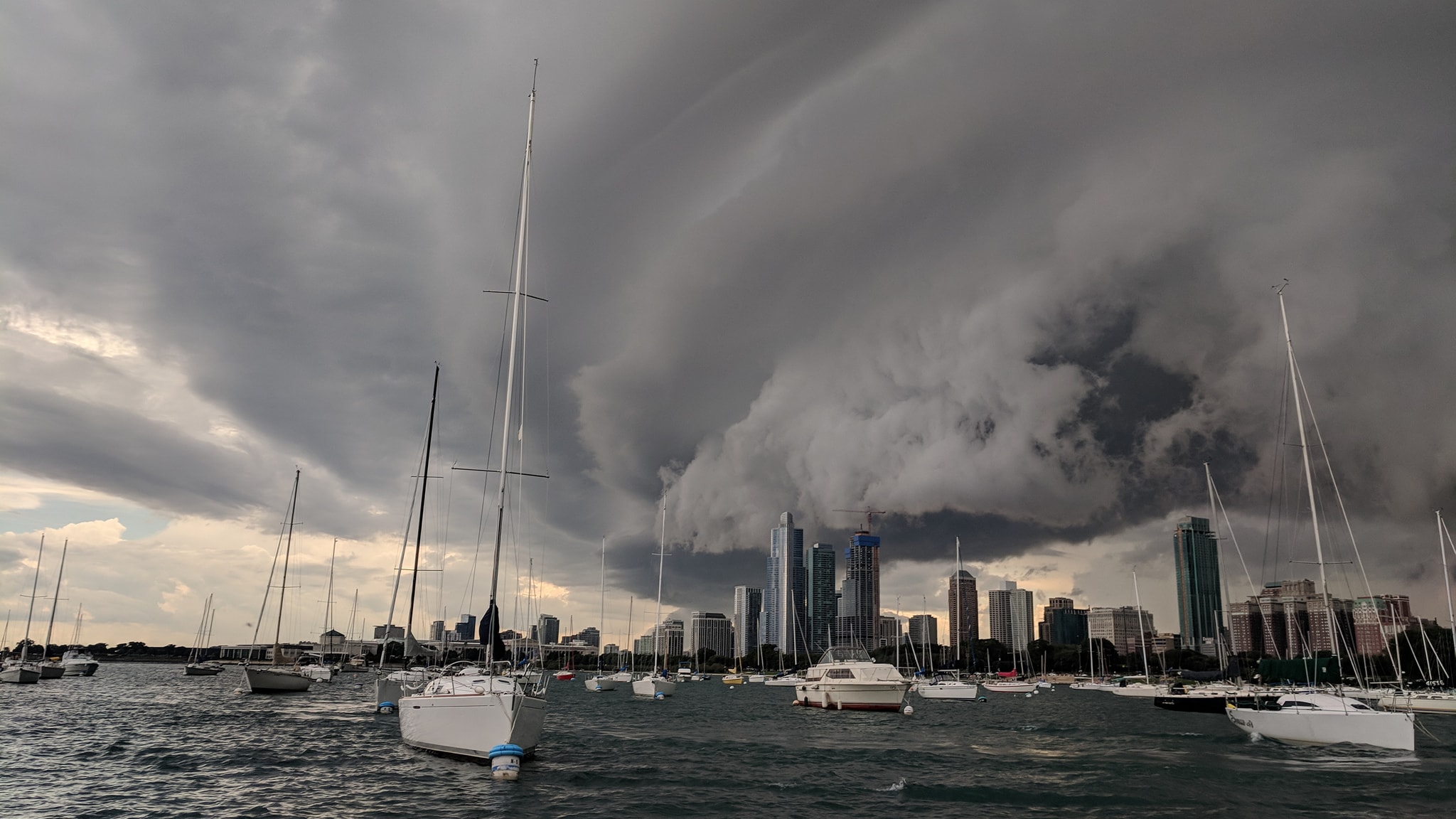 |
| Chicago skyline courtesy of Justin Bremer |
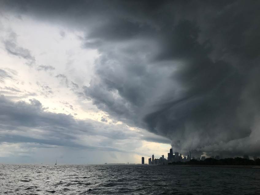 |
| Chicago courtesy of Nick Edwards |
 |
| Crown Point, IN courtesy of Eric Siedschlag |
 |
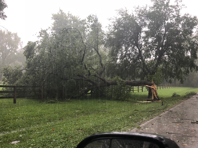 |
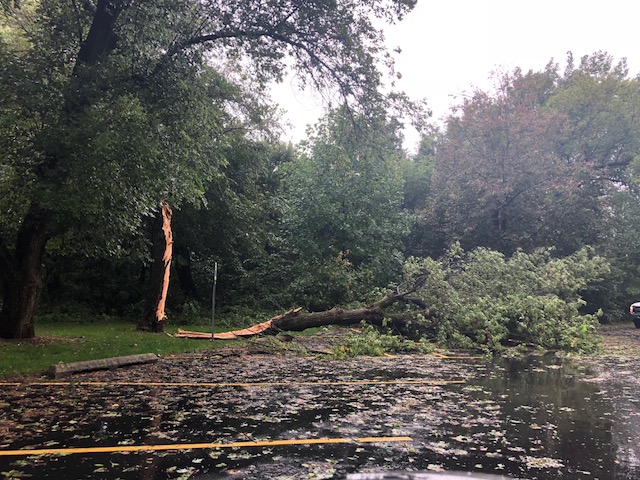
| Wayne, IL damage. Photo courtesy of Joe Pudlik. | Wayne, IL damage. Photo courtesy of Joe Pudlik. |
Radar:
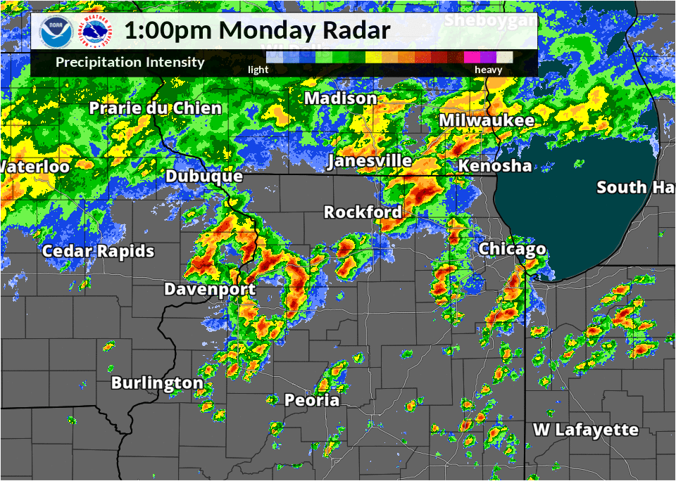 |
| Sept 3 1 pm - 7 pm Radar Loop |
Storm Reports
PRELIMINARY LOCAL STORM REPORT...SUMMARY
NATIONAL WEATHER SERVICE CHICAGO/ROMEOVILLE IL
1208 PM CDT TUE SEP 4 2018

..TIME...   ...EVENT...      ...CITY LOCATION...     ...LAT.LON...
..DATE...   ....MAG....      ..COUNTY LOCATION..ST.. ...SOURCE....
            ..REMARKS..

0930 AM     FLASH FLOOD      5 NNW LAKE FOREST       42.30N 87.88W
09/03/2018                   LAKE               IL   BROADCAST MEDIA

            ROUTE 41 CLOSED DUE TO FLOODING BETWEEN ROUTE 137 AND
            ROUTE 176. TWO CARS STUCK IN FLOOD WATERS. TIME
            ESTIMATED.

1158 AM     HEAVY RAIN       SOMONAUK                41.63N 88.68W
09/03/2018  M1.00 INCH       DE KALB            IL   TRAINED SPOTTER

            RAINFALL IN 9 MINUTES AS OF REPORT TIME. ALSO A BRIEF
            PERIOD OF WIND GUSTS ESTIMATED UP TO 50 MPH.

0110 PM     FLOOD            WOODSTOCK               42.31N 88.44W
09/03/2018                   MCHENRY            IL   CO-OP OBSERVER

            WATER FROM RETENTION PONDS HAS OVERFLOWN SOME STREETS
            WITH ABOUT 3 INCHES COVERING THEM.

0137 PM     LIGHTNING        1 NW BOLINGBROOK        41.72N 88.09W
09/03/2018                   WILL               IL   BROADCAST MEDIA

            *** 1 INJ *** A SMALL BOAT WITH TWO FISHERMEN STRUCK BY

            LIGHTNING IN WHALON LAKE FOREST PRESERVE. TIME ESTIMATED.

0142 PM     FUNNEL CLOUD     MCHENRY                 42.34N 88.29W
09/03/2018                   MCHENRY            IL   TRAINED SPOTTER

            FUNNEL CLOUD OBSERVED AND DID NOT REACH THE GROUND. TIME
            ESTIMATED.

0156 PM     TSTM WND GST     WESTMONT                41.80N 87.97W
09/03/2018  E60.00 MPH       DUPAGE             IL   PUBLIC

0200 PM     LIGHTNING        BROOKFIELD              41.82N 87.85W
09/03/2018                   COOK               IL   BROADCAST MEDIA

            STRUCK A CONDO BUILDING.

0212 PM     FLASH FLOOD      OHARE AIRPORT           41.98N 87.90W
09/03/2018                   COOK               IL   BROADCAST MEDIA

            FLOODING OF A PORTION OF THE INTERIOR OF TERMINAL 5.

0212 PM     FLASH FLOOD      4 SSE DES PLAINES       41.98N 87.88W
09/03/2018                   COOK               IL   BROADCAST MEDIA

            INTERSTATE 190 NEAR OHARE AIRPORT CLOSED IN BOTH
            DIRECTIONS DUE TO SIGNIFICANT FLOODING NEAR WHERE
            MANNHEIM ROAD CROSSES OVER THE INTERSTATE AND THE
            CANADIAN NATIONAL RAILWAY BRIDGE CROSSES OVER THE
            INTERSTATE.

0216 PM     TSTM WND DMG     4 W CHICAGO             41.88N 87.71W
09/03/2018                   COOK               IL   NWS EMPLOYEE

            LARGE TREES AND BRANCHES DOWN IN GARFIELD PARK. LARGE
            TREE BLOCKING ROAD IN THE SOUTHERN PART OF GARFIELD PARK.
            BRANCHES SCATTERED ACROSS I290 IN BETWEEN PULASKI AND
            KARLOV. POWER LINES DOWN ON BUILDING, ADDITIONAL TREE
            DAMAGE, AND ROOF DAMAGE SOUTH OF I290 AROUND KEELER. TIME
            OF DAMAGE IS ESTIMATED BASED ON RADAR. NWS WILL SEND OUT
            DAMAGE SURVEY CREW TUESDAY MORNING TO ASSESS DAMAGE.

0225 PM     FUNNEL CLOUD     ADELINE                 42.14N 89.49W
09/03/2018                   OGLE               IL   TRAINED SPOTTER

            SPOTTER VIDEO OF A BRIEF ROTATING FUNNEL DOWN AT LEAST
            THREE-QUARTERS OF THE WAY TO THE GROUND.

0225 PM     LIGHTNING        6 NNE FOREST PARK       41.94N 87.76W
09/03/2018                   COOK               IL   PUBLIC

            HOUSE STRUCK AND DAMAGED IN THE SOUTHERN PART OF THE
            PORTAGE PARK NEIGHBORHOOD OF CHICAGO. REPORTED ON SOCIAL
            MEDIA. TIME ESTIMATED.

0226 PM     HEAVY RAIN       6 S EVANSTON            41.96N 87.70W
09/03/2018  M1.25 INCH       COOK               IL   COCORAHS

            RAINFALL 1.26 INCHES IN 30 MINUTES.

0228 PM     TSTM WND DMG     3 NW LINCOLN PARK       41.96N 87.67W
09/03/2018                   COOK               IL   TRAINED SPOTTER

            ONE LARGE TREE AND ONE LARGE TREE LIMB BLOWN DOWN NEAR
            CLARK AND MONTROSE. TIME ESTIMATED.

0228 PM     TSTM WND DMG     6 SSE EVANSTON          41.97N 87.66W
09/03/2018                   COOK               IL   BROADCAST MEDIA

            TWO LARGE BRANCHES DOWNED IN UPTOWN NEIGHBORHOOD ON FAR
            NORTH SIDE OF CHICAGO. TIME ESTIMATED.

0249 PM     FUNNEL CLOUD     4 NNE LEAF RIVER        42.18N 89.37W
09/03/2018                   OGLE               IL   TRAINED SPOTTER

            BRIEF FUNNEL CLOUD AT LEAST HALF WAY TO THE GROUND.

0315 PM     TSTM WND DMG     WAYNE                   41.95N 88.26W
09/03/2018                   DUPAGE             IL   TRAINED SPOTTER

            SEVERAL LARGE TREES AND TREE LIMBS BLOWN DOWN. ONE
            UTILITY POLE BLOWN DOWN. MAINLY NEAR AND WEST OF POWIS
            ROAD AND NEAR AND NORTH OF ARMY TRAIL ROAD. RADAR
            INDICATES THIS WAS VERY LIKELY DUE TO A STRONG DOWNBURST.
            TIME RADAR ESTIMATED.

0330 PM     FLOOD            ROSCOE                  42.42N 89.01W
09/03/2018                   WINNEBAGO          IL   TRAINED SPOTTER

            FLOODED PARK.

0400 PM     FLOOD            3 SSW GAGES LAKE        42.31N 88.00W
09/03/2018                   LAKE               IL   BROADCAST MEDIA

            PARTIALLY COLLAPSED WALL ON A RAILROAD UNDERPASS ALONG
            U.S. HIGHWAY 45.

0415 PM     FLOOD            5 N DEERFIELD           42.24N 87.86W
09/03/2018                   LAKE               IL   BROADCAST MEDIA

            SOUTHBOUND U.S. HIGHWAY 41 WAS CLOSED SOUTH OF ROUTE 60
            DUE TO WATER ON THE ROADWAY UNDER A LOW-LYING BRIDGE. IT
            WAS NOTED THAT THIS IS A FAMILIAR SCENARIO. TIME
            ESTIMATED.

0447 PM     FLOOD            1 WSW CHICAGO           41.88N 87.65W
09/03/2018                   COOK               IL   BROADCAST MEDIA

            KENNEDY FLOODED SOUTHBOUND AT JANE BYRNE
            INTERCHANGE...INTERSTATE 90 94 290 INTERCHANGE. RELAYED
            VIA TWITTER.

0450 PM     FLOOD            4 ESE ALSIP             41.64N 87.66W
09/03/2018                   COOK               IL   BROADCAST MEDIA

            FAR LEFT LANE OF I-57 IN BOTH DIRECTIONS CLOSED DUE TO
            FLOODING NEAR MILE MARKER 351. RELAYED VIA TWITTER.
Additional Info
 |
Media use of NWS Web News Stories is encouraged! Please acknowledge the NWS as the source of any news information accessed from this site. Additional recaps can be found on the NWS Chicago Past Events Page |
|