|
Take a moment to learn more about severe weather preparedness and safety: Ensure you have weather safety procedures at home, work, school, place of worship, on the road, and elsewhere. Decision-makers and overseers of large groups of people should review preparedness plans and ensure they have adequate means to monitor the weather and shelter individuals. Be a "Force of Nature" and spread awareness of severe weather! |
|
 |
 |
|
Severe Weather Safety Planning |
|
|
Basic Safety Checklist |
Three Things You Should Know |
|
|
|
|
Know what to include in your safety plan, where to get weather information, have multiple methods to get alerts, and be able to quickly activate your plan! Knowing this information should improve your chances of being safe if severe weather threatens. |
1. Have a predetermined safe spot. |
|
|
|
|
Ways to Prepare for Disasters |
|
|
|
|
|
Make a severe weather plan before you need it! Your family may not be together when a disaster strikes, so it is important to plan in advance: how you will get to a safe place, how you will contact one another, how you will get back together, and what you will do in different situations. Now is a great time to spend some time developing a plan and creating a supply kit! |
Don’t wait until the day of the storm to begin protecting yourself. If the forecast calls for severe weather, begin preparing NOW. Stay Weather-Ready. |
|
Severe Weather Watches and Warnings Do you know the differences between a watch and a warning? |
|
|
Thunderstorm Watch vs Warning |
Tornado Watch vs Warning |
 |
 |
|
|
|
|
Watches vs Warnings: Another Perspective |
Particularly Dangerous Situation (PDS) |
|
Ever have trouble remembering the difference between a Watch and a Warning? Think of it in terms of baking a cupcake. When you have all of your ingredients in place (your flour, butter, eggs, sugar, etc.) you are under a "Cupcake Watch". When all the ingredients are put together and finished baking, your end result is a “Cupcake Warning”! Similarly for severe thunderstorms and tornadoes, a Severe Thunderstorm or Tornado Watch will be issued when the ingredients for severe weather are in place, and a Severe Thunderstorm or Tornado Warning will be issued when severe weather is imminent or already occurring! |
Have you ever noticed the wording “THIS IS A PARTICULARLY DANGEROUS SITUATION” in severe weather watches? Here’s what it means. |
|
|
|
|
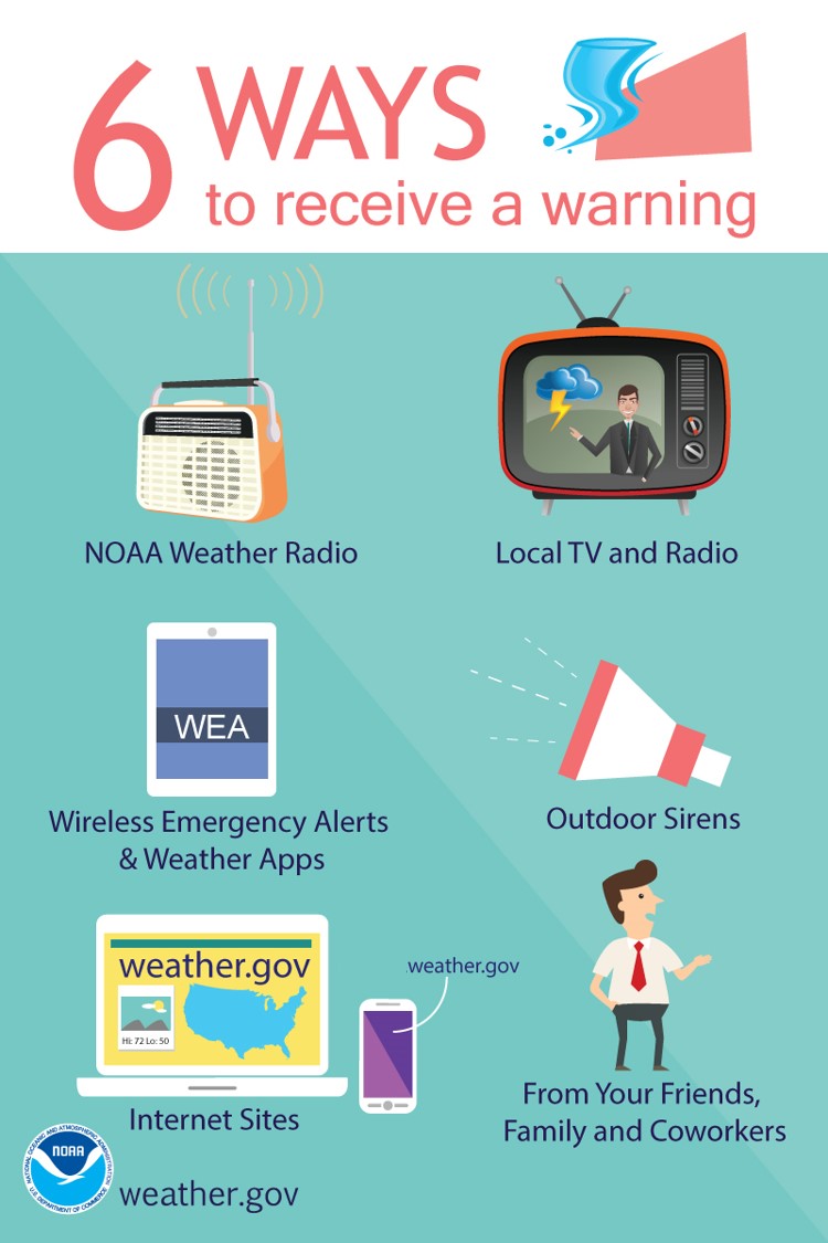
Methods To Receiving Warning Information It is important to have multiple ways to receive warnings in case one of them fails! |
|
|
|
|
|
Are Wireless Emergency Alerts enabled on your phone? They could save your life! Learn more at: weather.gov/wrn/wea. |
|
|
|
|
 |
|
|
**Important reminders about outdoor warning sirens** |
It is important to have multiple methods to receive weather warnings! Plan for things like power outages, poor reception, etc. NOAA Weather Radio alerts and wireless emergency alerts (WEAs) save lives! |
|
|
|
|
|
|
|
Tornado Safety |
|
|
|
|
|
You know to take shelter immediately if your area receives a Tornado Warning. But what makes a good shelter? Take the time now to figure out your options and make sure you’re Weather-Ready. |
Tornadoes can be extremely dangerous. Safe places include storm shelters and basements — but if not available, an interior room without windows can also be protective. If you receive a tornado warning, take shelter immediately! |
|
|
|
|
|
|
|
Imagine you’re relaxing at home...when all of a sudden, a Tornado Warning comes through on your phone or NOAA Weather Radio. Where will you go to stay safe? |
Tornadoes can happen at any time of day! If severe weather is forecast for your area, take a few quick moments to prepare yourself before lying down for the night. |
|
|
|
 |
 |
|
During a tornado, seeking refuge in a vehicle or under an overpass is NOT safe. If you are outside during a tornado warning, the best option is to drive to a designated shelter, basement, or safe room. |
It's critical to stay informed about possible severe weather when you travel. Know before you go! |
|
|
|
 |
 |
|
Does your workplace have a designated tornado shelter? Does your workforce know what to do when severe weather threatens? |
If you are impacted by tornado damage: Listen to local officials, stay up-to-date on the forecast, contact loved ones (to let them know your status), and be mindful of debris (such as glass and nails) and downed power lines. Have a working radio with batteries available, and use flashlights instead of candles to avoid starting fires. |
|
Safety from Damaging Winds and Hail |
||
|
|
|
|
|
During high winds, tree damage is expected, and loose objects can become airborne and dangerous. You are safest indoors, away from windows, in an interior room! |
What should you do if you are caught in a hail storm while driving? Pull off the road if possible and point your vehicle into the wind. The windshield is the strongest window. However, DO NOT park under overpasses! If several other cars follow your lead this could end up blocking the flow of traffic, including for emergency vehicles! Cover yourself in case the windows shatter and debris enters the vehicle (such as a jacket or floor mat). |
|
|
|
|
|
 |
|
|
|
Thunderstorms and squall lines can quickly turn clear skies dark. Stay Weather-Ready by having a way to get weather alerts on your phone, and stay safe by immediately going inside when the skies turn threatening. |
Tornadoes, large hail, strong winds, heavy rain, and lightning are all hazards associated with severe weather. Severe weather has been reported in all 50 states, so no matter where you are, make sure you are prepared! |
|
|
Lightning Safety |
|||
|
|
|
||
|
Your chance of being struck by lightning greatly increases when remaining outdoors during a thunderstorm. Lightning can strike from up to 10 miles away. When thunder roars, go indoors! See a flash, dash inside! |
Whether you’re playing or watching sports outdoors, the same rule applies: When Thunder Roars Go Indoors! It is never safe to be outside when lightning is in the area. Step 1: Leave the field immediately. Step 2: Seek shelter in an enclosed building or car (windows up). Wait 30 minutes after hearing thunder to return outside. |
||
|
|
|
||
 |
|
||
|
Lightning strikes can result in death or serious injury. If you hear thunder or see lightning, immediately take shelter in an enclosed building or a hard-topped vehicle with the windows up. |
Lightning strikes the United States about 25 million times each year! Thunderstorms produce deadly lightning capable of striking up to 10 miles away from the storm — so, even if you don't see rain you could be in harm’s way. Remember this simple message: When Thunder Roars, Go Indoors! |
||
|
|
|
||
|
|
|
||
|
Whether you’re spending the day at the beach or an afternoon at the pool, at the first sign of a storm, you should gather your things and seek shelter. By the time you hear thunder or see lightning, you’re already in danger. When Thunder Roars, Go Indoors! |
Thunderstorms can be a beachgoers or boaters worst nightmare. They can develop quickly and can produce strong wind, pounding rain, deadly lightning, and damaging hail with very few places for shelter. Even marginal thunderstorm winds can capsize certain boats and other floating vessels. If you are at the beach or out on the water and see clouds quickly growing in the distance, thunderstorms may be developing. Don’t wait until you can hear thunder or see lightning. It is best to head for safe shelter at the first sign of a developing storm. |
||
|
|
|
||
 |
|
||
|
Be aware of the dangers of lightning when going fishing. A lightning strike to a vessel can be destructive, especially if it results in a fire or loss of electronics. Boaters should use extra caution when thunderstorm conditions exist and have a plan of escape. |
Did you know that lightning is hotter than the surface of the Sun? Stay Weather-Ready and learn about lightning science at weather.gov/safety/lightning-science |
||
|
Storm Prediction Center Severe Weather Outlooks |
|||
|
|
 |
||
|
|
|
||
|
Performing a Daily Weather Assessment on Days when Thunderstorms are in the Forecast |
|||
|
|
|
||
|
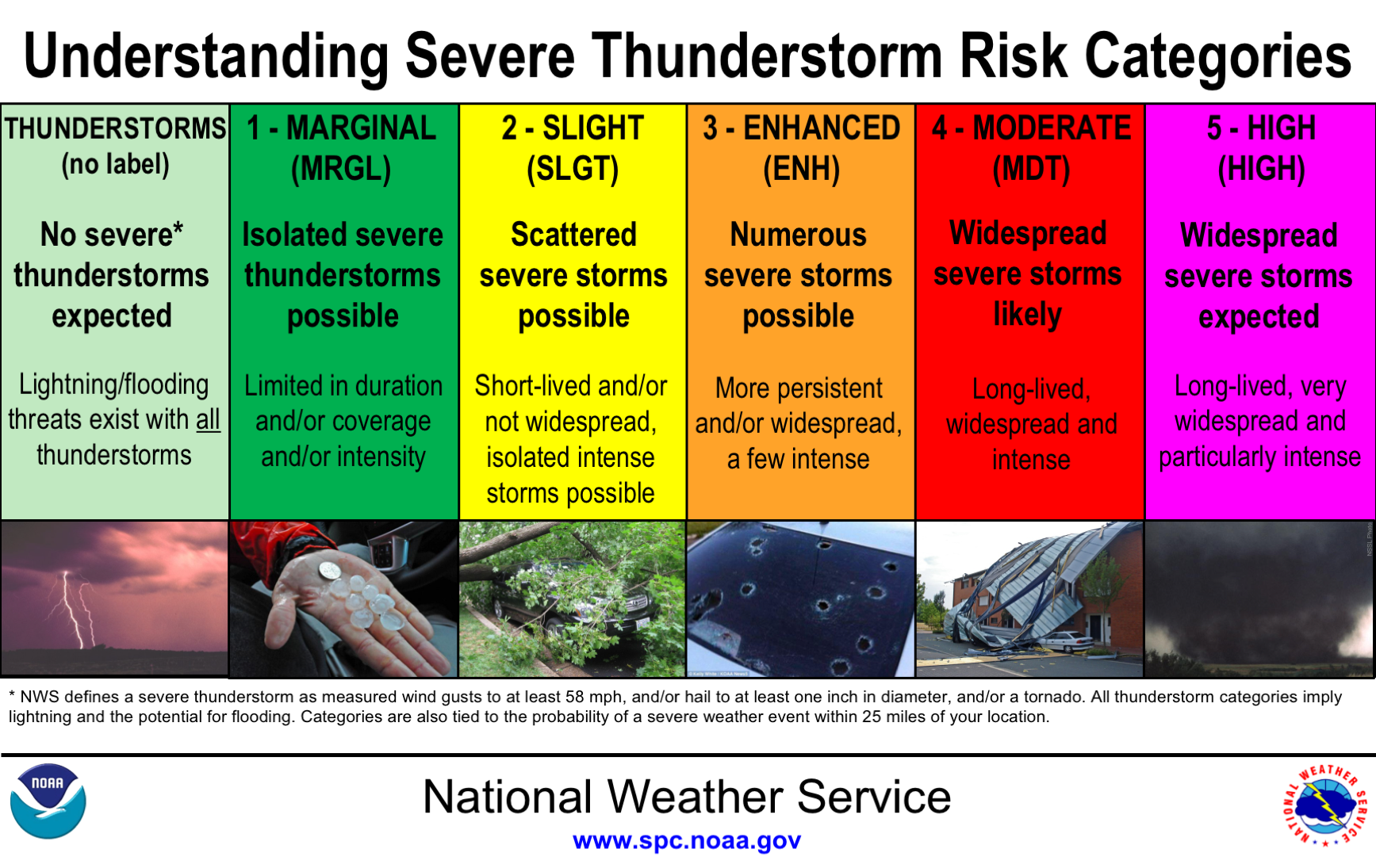
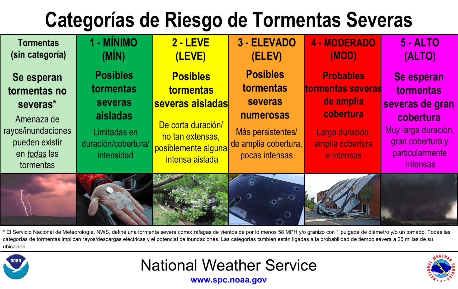
One great tool you can use to start your daily weather assessment is visiting the webpage for the Storm Prediction Center, spc.noaa.gov. The Storm Prediction Center is a National Center in the National Weather Service, and they are tasked with forecasting severe weather for up to 8 days in the future. The table on the slide shows the different categories, which range from 1 to 5. Our area typically experiences a handful of Level 2 and 3 threat levels in an average year. Level 4 and 5 threat level severe outlooks are rare in our area, and typically correspond to severe weather outbreaks. |
You can also visit the homepage of the NWS Chicago office, weather.gov/Chicago, as part of your daily weather assessment. On our homepage, we have daily graphics showcasing the main weather stories for the day and week. On days for which severe weather is forecasted, we downscale the outlooks from the Storm Prediction Center and also highlight the primary threats for thunderstorms. We also include the storm motion for the day, which is important to know from what direction storms will be coming. |
||
|
How to Report Severe Weather to the NWS |
|||
|
Accurate and timely reports are extremely important to us in the National Weather Service! We use them real-time for ground truth and often include reports in updates to warnings! Broadcast media often relays our reports on the air live or during stories on impactful storms. |
|||
|
|
|
||
|
|
|||
|
|
 |
||
|
|
|||
|
|
 |
||
|
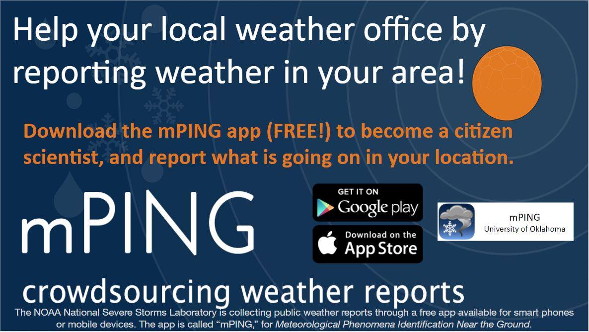
mPING. (Meteorological Phenomena Identification Near the Ground project). Weird name, cool app! Users can report weather conditions they are experiencing. Use the free mobile app to send reports anonymously. Reports are automatically recorded into a database. For more information visit: mping.nssl.noaa.gov/ |
Have you ever wondered how tornadoes are officially confirmed? Meteorologists at National Weather Service forecast offices apply a careful, thorough process with roughly 4 steps. | ||
 |
Media use of NWS Web News Stories is encouraged! Please acknowledge the NWS as the source of any news information accessed from this site. |
|