Overview
|
An intense storm system lifted northeast across the mid-Mississippi Valley on Saturday, November 5th. South winds began to increase significantly early in the morning, following passage of an area of showers, and were strongest later in the morning. A skinny line of showers, which accompanied the cold front, helped bring down some of the strongest winds aloft to further enhance the winds at the surface. The strongest gusts were in east central Illinois, where 68 mph was reported at Willard Airport south of Champaign. Widespread winds of 50 to 60 mph were reported across much of the remainder of central Illinois. |
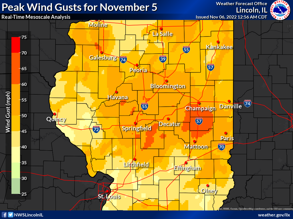 Peak wind gusts, from the Real-Time Mesoscale Analysis |
Photos & Video
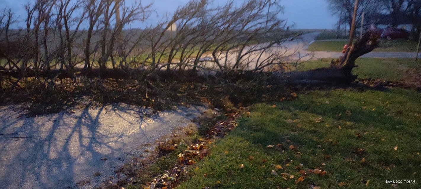
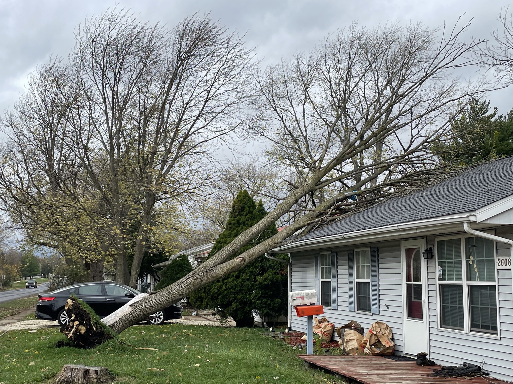
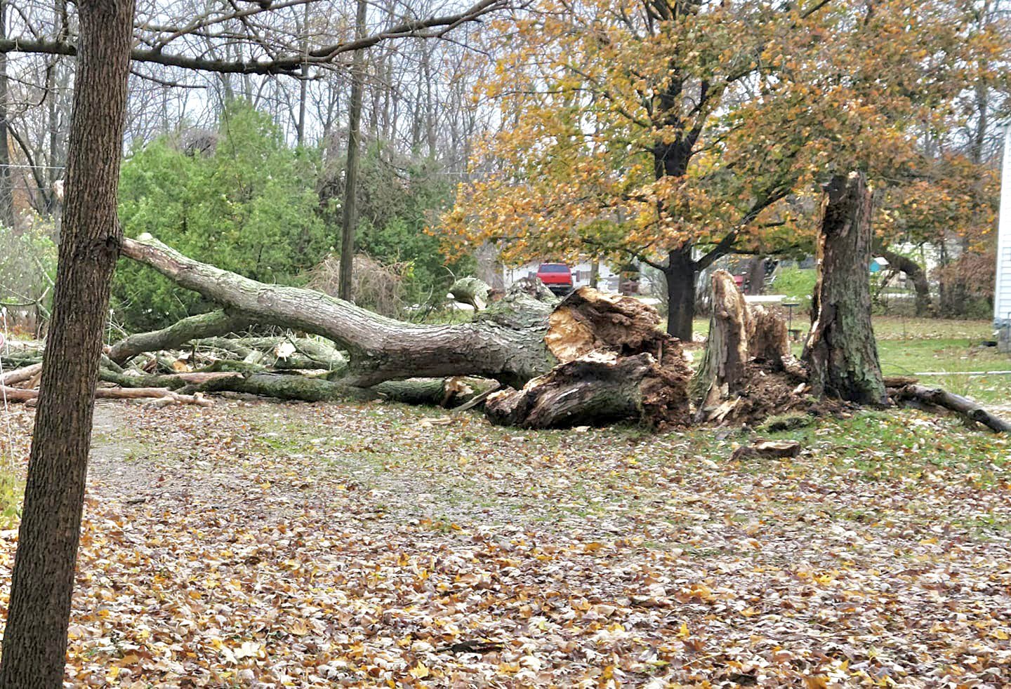
Wind damage
 |
 |
 |
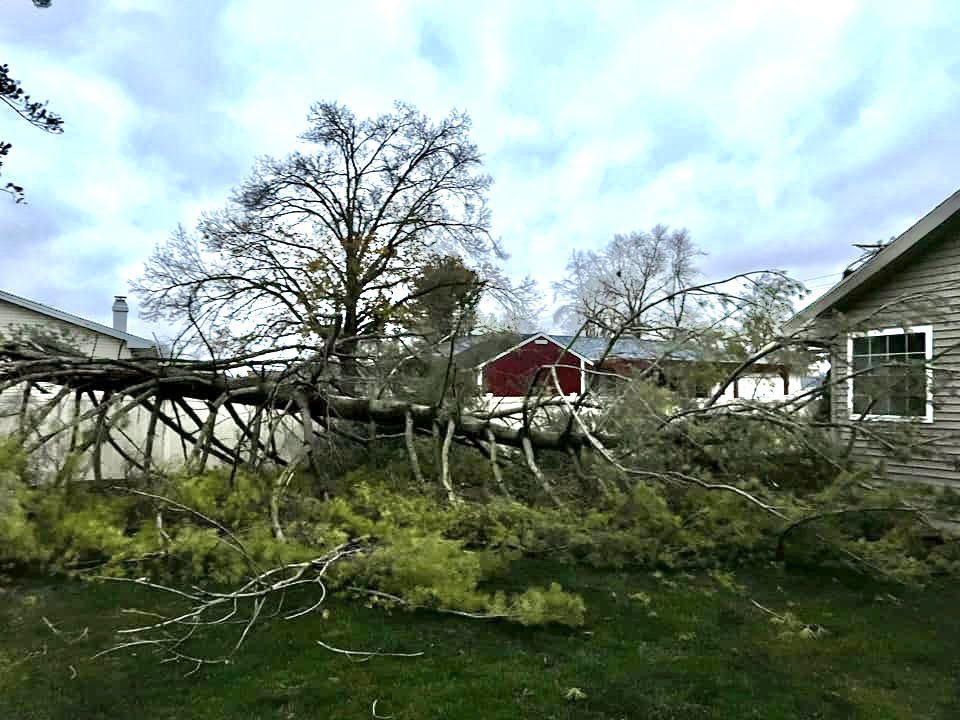 |
| Redmon (Phillip Coleman) |
Urbana (Andrew Pritchard) |
Tilton (Allen Cockrell) |
Charleston (Jason Richardson) |
Radar
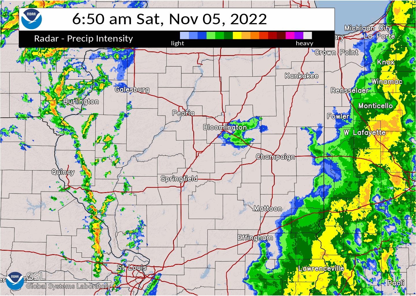
Little lightning was noted with the skinny line of heavy showers that moved east across the region during the morning. However, some of the strongest winds aloft were brought closer to the surface, enhancing the already windy conditions. Peak wind gusts in Peoria were highest when this line passed through the city.
Storm Reports
​Wind speed measurements:

Location                     Speed     Time/Date       Provider
Savoy/Willard Arpt           68 MPH    0948 AM 11/05   ASOS
Urbana                       66 MPH    1020 AM 11/05   CWOP
Towanda                      65 MPH    1015 AM 11/05   CWOP
Coles Co. Mem AP             60 MPH    1016 AM 11/05   ASOS
Bloomington                  59 MPH    0149 PM 11/05   CWOP
Decatur Arpt                 59 MPH    1011 AM 11/05   ASOS
Peoria Intl Arpt             59 MPH    0901 AM 11/05   ASOS
Edgar Co. Arpt               59 MPH    0715 AM 11/05   AWOS
Plainfield                   56 MPH    0634 AM 11/05   CWOP
Springfield Capital AP       56 MPH    0701 AM 11/05   ASOS
Rantoul Arpt                 55 MPH    1055 AM 11/05   AWOS
Lawrenceville AP             54 MPH    0802 AM 11/05   ASOS
Bloomington Arpt             52 MPH    0250 PM 11/05   AWOS
Danville Arpt                51 MPH    1235 PM 11/05   AWOS
Toluca                       48 MPH    0255 PM 11/05   DAVIS
Arcola                       47 MPH    0200 PM 11/05   DAVIS
Jacksonville Arpt            47 MPH    0755 AM 11/05   AWOS
Olney Noble AP               47 MPH    0915 AM 11/05   AWOS
Robinson Arpt                47 MPH    0755 AM 11/05   AWOS
Germantown Hills             46 MPH    0746 AM 11/05   CWOP
Casey                        46 MPH    0945 AM 11/05   CWOP
Flora Arpt                   46 MPH    0715 AM 11/05   AWOS
Taylorville Arpt             46 MPH    0915 AM 11/05   AWOS
Tallula                      45 MPH    0135 PM 11/05   CWOP
Sullivan                     45 MPH    1015 AM 11/05   CWOP
New Holland                  44 MPH    0645 AM 11/05   CWOP
Rushville                    44 MPH    1230 PM 11/05   CWOP
Arcola                       44 MPH    0135 PM 11/05   CWOP
Galesburg Arpt               44 MPH    1055 AM 11/05   AWOS
Effingham Arpt               43 MPH    0215 PM 11/05   AWOS
Mt Carmel Arpt               43 MPH    0135 PM 11/05   AWOS
Waynesville                  42 MPH    1000 AM 11/05   CWOP
Cooksville                   42 MPH    0316 PM 11/05   CWOP
Lacon Arpt                   41 MPH    0815 AM 11/05   AWOS
..TIME...   ...EVENT...      ...CITY LOCATION...     ...LAT.LON...
..DATE...   ....MAG....      ..COUNTY LOCATION..ST.. ...SOURCE....
            ..REMARKS..
0530 AM     NON-TSTM WND DMG 3 SSE CAMARGO           39.75N 88.15W
11/05/2022                   DOUGLAS            IL   PUBLIC

            LARGE LIMB FELL ON THE ROOF OF A HOUSE IN
            HUME.
0715 AM     NON-TSTM WND DMG OGDEN                   40.12N 87.96W
11/05/2022                   CHAMPAIGN          IL   PUBLIC

            VIDEO FROM SOCIAL MEDIA SHOWS A TRAILER
            OVERTURNED ON I-74 WESTBOUND NEAR THE OGDEN
            ROYAL EXIT.
0715 AM     NON-TSTM WND DMG TILTON                  40.10N 87.65W
11/05/2022                   VERMILION          IL   PUBLIC

            PHOTOS FROM SOCIAL MEDIA SHOW A LARGE BUT
            DECAYED MAPLE TREE SNAPPED AT THE BASE.
0715 AM     NON-TSTM WND DMG CHARLESTON              39.49N 88.18W
11/05/2022                   COLES              IL   PUBLIC

            TREE DOWN.
0720 AM     NON-TSTM WND DMG REDMON                  39.64N 87.86W
11/05/2022                   EDGAR              IL   PUBLIC

            TREE DOWN.
0730 AM     NON-TSTM WND DMG KANSAS                  39.55N 87.94W
11/05/2022                   EDGAR              IL   BROADCAST MEDIA

            DAMAGE TO A GRAIN ELEVATOR, WITH ASSOCIATED
            POWER LINE DAMAGE. RELAYED VIA WCIA-TV. TIME
            ESTIMATED.
0900 AM     TSTM WND DMG     1 SE YATES CITY         40.77N 90.00W
11/05/2022                   KNOX               IL   PUBLIC

            PHOTOS FROM SOCIAL MEDIA SHOW A DAMAGED AND
            OVERTURNED LARGE STRUCTURE. TIME WAS
            ESTIMATED FROM RADAR.
0930 AM     NON-TSTM WND DMG FARMINGTON              40.70N 90.01W
11/05/2022                   FULTON             IL   BROADCAST MEDIA

            DELAYED REPORT. SMALL OUTBUILDING/SHED
            OVERTURNED DUE TO STRONG NON THUNDERSTORM
            WINDS. RELAYED VIA BROADCAST MEDIA.
0950 AM     NON-TSTM WND DMG URBANA                  40.11N 88.20W
11/05/2022                   CHAMPAIGN          IL   PUBLIC

            PHOTOS FROM SOCIAL MEDIA SHOW A DEAD, DOWNED
            TREE UPROOTED AND ON A HOUSE.
1025 AM     TSTM WND DMG     GRIDLEY                 40.74N 88.88W
11/05/2022                   MCLEAN             IL   BROADCAST MEDIA

            GAS STATION CANOPY DESTROYED AS A LINE OF
            SHOWERS MOVED THROUGH. TIME ESTIMATED VIA
            RADAR. RELAYED VIA WCIA-TV.

1030 AM     NON-TSTM WND DMG 2 N CHAMPAIGN           40.15N 88.26W
11/05/2022                   CHAMPAIGN          IL   BROADCAST MEDIA

            SIGN DAMAGED ON BUILDING AT INTERSECTION OF
            INTERSTATE DR. AND N. PROSPECT AVE. TIME
            ESTIMATED. RELAYED VIA WCIA-TV.
1045 AM     NON-TSTM WND DMG 2 WSW URBANA            40.10N 88.23W
11/05/2022                   CHAMPAIGN          IL   PUBLIC

            DELAYED REPORT. SOCIAL MEDIA IMAGE OF A
            LARGE TREE BRANCH SNAPPED AT THE UNIVERSITY
            OF ILLINOIS.
1230 PM     NON-TSTM WND DMG 1 W HOOPESTON           40.46N 87.69W
11/05/2022                   VERMILION          IL   BROADCAST MEDIA

            PORTION OF PARK PAVILION ROOF PEELED OFF AT
            MCFERRIN PARK. TIME ESTIMATED.
Environment
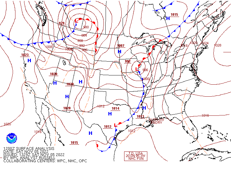
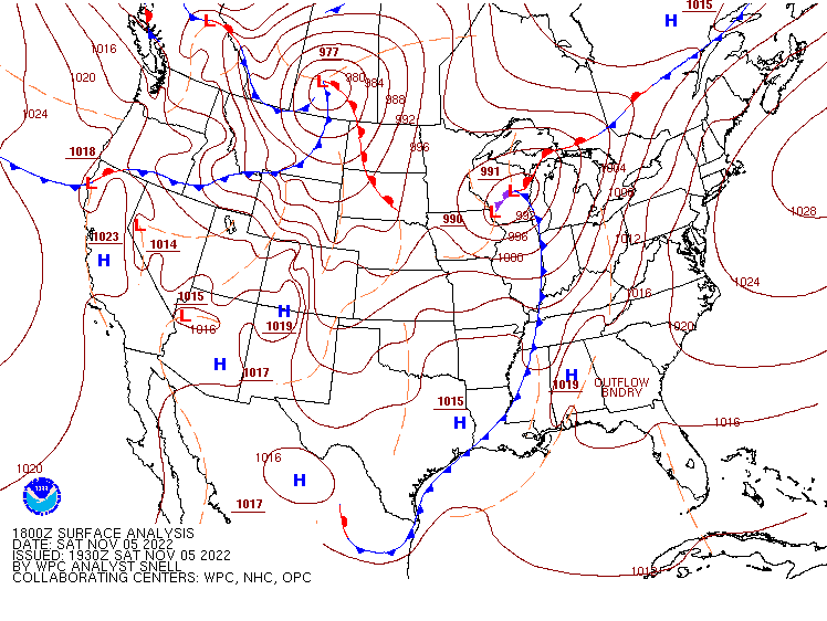
The intensifying storm system lifted out of the southern Plains Friday night, and was centered over southern Iowa early Saturday morning. By evening, it had reached Lake Superior. (Figures 1 through 3 below show the track.)
 |
 |
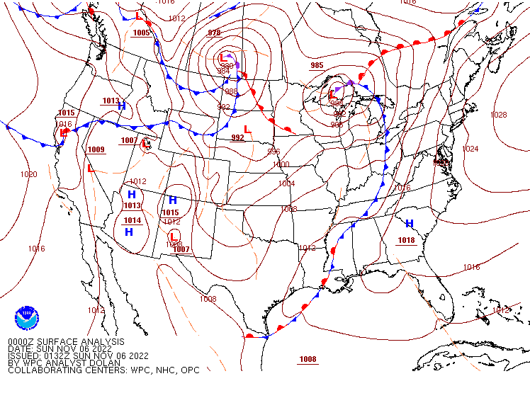 |
| Figure 1: Weather map from 7 am CDT | Figure 2: Weather map from 1 pm CDT | Figure 3: Weather map from 7 pm CDT |
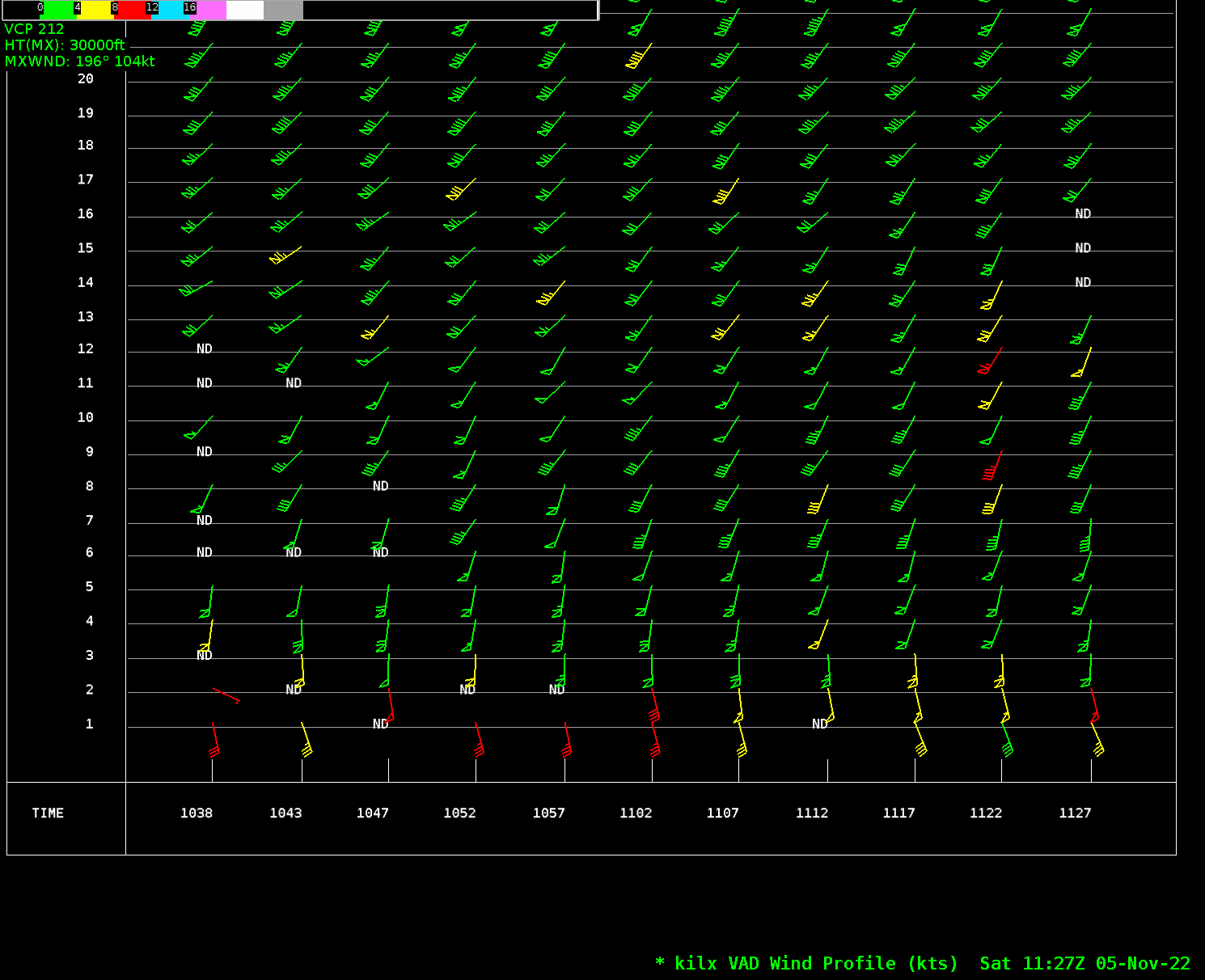
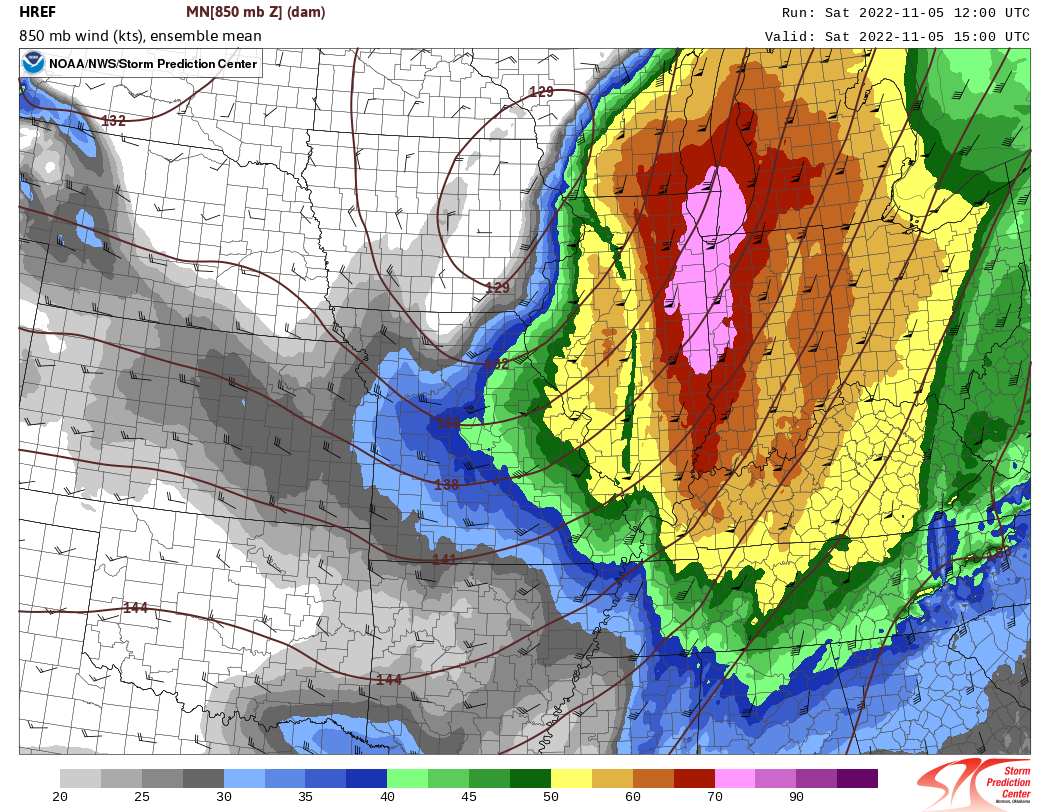
Very strong low level winds were moving into the region early in the morning. A vertical sample from our radar (figure 4) showed wind speeds around 70 knots (around 80 mph) about 3000-4000 feet off the ground. Model ensemble guidance picked up on that and showed it expanding across east central and northeast Illinois (figure 5, pink shades). This lined up with some of the strongest wind gusts mesured at the surface.
 |
 |
|
| Figure 4: Vertical wind profile from Lincoln Doppler radar around 6:30 am | Figure 5: HREF model guidance for 10 am of wind speeds at 4000 ft. above ground | Figure 6: Caption |
Additional environmental data.
| Figure 7: Caption | Figure 8: Caption | Figure 9: Caption |
 |
Media use of NWS Web News Stories is encouraged! Please acknowledge the NWS as the source of any news information accessed from this site. |
|

