Overview
|
A strong low pressure system (987 mb) moved across Illinois during the afternoon on Sunday, March 15, 2026. The environment was characterized by high shear and weak instability. A line of storms swept across the state, producing scattered wind damage and a few tornadoes. Following the cold frontal passage, much colder air moved into the region, resulting in rain changing to snow. Snow accumulations of 1-4" occurred along and west of I-55. Strong westerly winds gusting 40-50 mph led to blowing snow and near white out conditions at times through the day on Monday, March 16th. |
 Surface Map from 4 PM CDT on March 15, 2026. |
Tornadoes
Select a tornado from the table to zoom into the track and view more information. The default table view is limited to 8 tracks, but can be scrolled by a mouse wheel or dynamically expanded. Additionally, the table can fill the entire window by clicking the small circular expanding arrow icon at the very top right of the table and returned to its original size by clicking the button again. The side information panel that opens over the map can be closed using the "X" on the upper right corner of the pop-up. Zoom into the map and click damage points to see detailed information and pictures from the surveys.
|
NOTE: times shown below are local to your device's time zone. |

The Enhanced Fujita (EF) Scale classifies tornadoes into the following categories:
| EF0 Weak 65-85 mph |
EF1 Moderate 86-110 mph |
EF2 Significant 111-135 mph |
EF3 Severe 136-165 mph |
EF4 Extreme 166-200 mph |
EF5 Catastrophic 200+ mph |
 |
|||||
| Tornadoes that fail to impact any ratable damage indicators on the EF-Scale are rated EF-Unknown (EF-U) | |||||
Storm Reports
Note: This storm report summary does not include potential tornado damage survey information.

Preliminary Local Storm Report...Summary
National Weather Service Lincoln IL
943 AM CDT Mon Mar 16 2026

..TIME...   ...EVENT...      ...CITY LOCATION...     ...LAT.LON...
..DATE...   ....MAG....      ..COUNTY LOCATION..ST.. ...SOURCE....
            ..REMARKS..

0514 PM     Tstm Wnd Dmg     2 S Chatham             39.64N 89.70W
03/15/2026                   Sangamon           IL   Emergency Mngr

            Powerlines down.

0530 PM     Tstm Wnd Gst     2 SSE Grandview         39.79N 89.62W
03/15/2026  M55 MPH          Sangamon           IL   Mesonet

            Mesonet station NGC53 Lincoln Land Community
            College.

0540 PM     Tstm Wnd Dmg     Lincoln                 40.15N 89.36W
03/15/2026                   Logan              IL   Fire Dept/Rescue

            Large tree downed by thunderstorm winds.
            Delayed report. Time estimated from radar.

0602 PM     Hail             1 N Taylorville         39.56N 89.30W
03/15/2026  E1.25 Inch       Christian          IL   Public

            Report from mPING: Half Dollar (1.25 in.).

0603 PM     Tstm Wnd Gst     7 WSW Rosamond          39.35N 89.29W
03/15/2026  M59 MPH          Christian          IL   Mesonet

            SWOP report.

0603 PM     Tstm Wnd Dmg     8 WSW Rosamond          39.35N 89.30W
03/15/2026                   Christian          IL   Mesonet

            Photo of portion of high school roof torn
            off. SWOP report.

0603 PM     Tstm Wnd Gst     8 WSW Rosamond          39.35N 89.31W
03/15/2026  M56 MPH          Christian          IL   Mesonet

            SWOP report.

0610 PM     Tstm Wnd Gst     1 ENE Rosamond          39.39N 89.14W
03/15/2026  M70 MPH          Christian          IL   Trained Spotter


0617 PM     Tstm Wnd Dmg     Pana                    39.39N 89.08W
03/15/2026                   Christian          IL   Public

            Large, softwood tree uprooted. Relayed via
            broadcast media with photo.

0618 PM     Funnel Cloud     1 SW Maroa              40.03N 88.97W
03/15/2026                   Macon              IL   Trained Spotter


0620 PM     Tstm Wnd Dmg     Assumption              39.52N 89.05W
03/15/2026                   Christian          IL   Fire Dept/Rescue

            Corrects previous tstm wnd dmg report from
            Assumption. Tree down on a car. Multiple
            power lines downed throughout town.

0632 PM     Tstm Wnd Dmg     1 E Shelbyville         39.41N 88.79W
03/15/2026                   Shelby             IL   Law Enforcement

            Large tree limb down, about 8 inches in
            diameter, in the city of Shelbyville.
            Delayed report. Time estimated from radar.

0633 PM     Tstm Wnd Gst     1 WSW Decatur Airport   39.83N 88.87W
03/15/2026  M53 MPH          Macon              IL   ASOS

            ASOS station KDEC Decatur Arpt.

0644 PM     Tstm Wnd Gst     Sullivan                39.60N 88.61W
03/15/2026  E60 MPH          Moultrie           IL   Trained Spotter

            Estimated winds at least 50-60 mph. Video
            shared via social media.

0658 PM     Tstm Wnd Gst     2 SE Arthur             39.70N 88.45W
03/15/2026  M61 MPH          Douglas            IL   Public

            8 inch diameter tree branches down.

0658 PM     Tstm Wnd Dmg     2 SE Arthur             39.70N 88.45W
03/15/2026                   Douglas            IL   Public

            8 inch diameter branches down.

0659 PM     Tstm Wnd Dmg     2 SE Arthur             39.70N 88.44W
03/15/2026                   Douglas            IL   Public

            Roof blown off barn and tops of trees
            carried a couple hundred feet. Possible
            tornado.

0705 PM     Tstm Wnd Gst     Coles County Airport    39.47N 88.27W
03/15/2026  M51 MPH          Coles              IL   ASOS

            ASOS station KMTO Coles Co. Mem AP.

0712 PM     Tstm Wnd Dmg     1 ESE Tolono            39.98N 88.25W
03/15/2026                   Champaign          IL   Emergency Mngr

            tree fell on a home.

0725 PM     Tstm Wnd Gst     Louisville              38.77N 88.51W
03/15/2026  E60 MPH          Clay               IL   Trained Spotter

            Estimated winds at least 50-60 mph.

0755 PM     Tstm Wnd Gst     Flora Municipal Airport 38.67N 88.45W
03/15/2026  M54 MPH          Clay               IL   AWOS

            AWOS station KFOA Flora Arpt.

0855 PM     Tstm Wnd Gst     Robinson Municipal Airp 39.01N 87.65W
03/15/2026  M58 MPH          Crawford           IL   AWOS

            AWOS station KRSV Robinson Arpt.
Radar
 |
 |
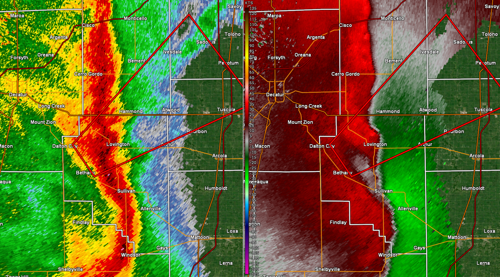 |
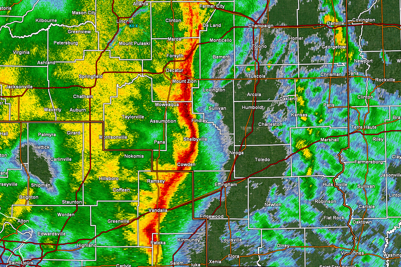
| Radar reflectivity showing a line of broken thunderstorms between the Illinois River and I-55 corridor, as of 4:37 pm on March 15, 2026. | Radar reflectivity showing a line of severe thunderstorms east of I-55 at 6:35 pm on March 15, 2026. | Radar reflectivity (left) and velocity (right) showing a line-embedded circulation at 6:42 pm on March 15, 2026. |
Environment
A strong low pressure system moved across Illinois on Sunday, March 15, 2026. Southerly winds gusted 45-55 mph ahead of the system, pushing temperatures into the 60s across central Illinois. At the same time, temperatures behind a strong cold front were in the 20s and 30s across Iowa.
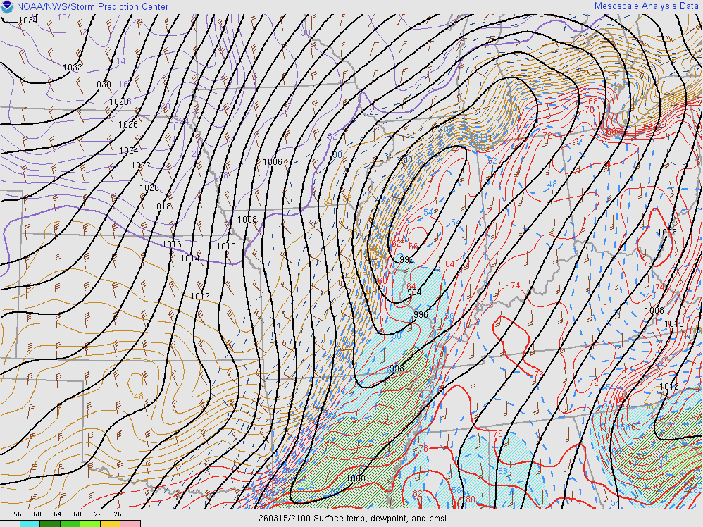 |
| Figure 1: Surface map from 4PM on March 15, 2026. |
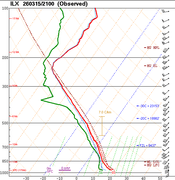
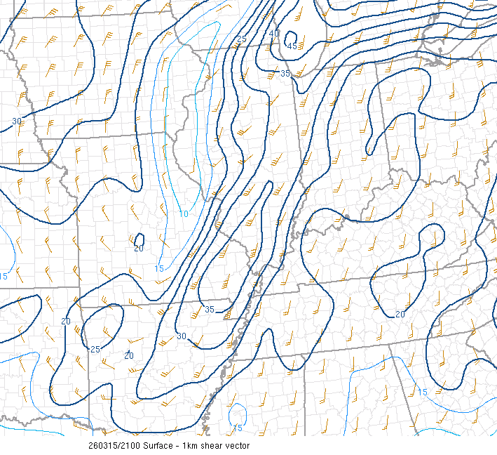
In the warm sector of the system, strong wind shear was present (60-70 knots of deep layer shear), along with weak to modest instability (less than 1000 J/kg of surface-based CAPE). A broken line of thunderstorms developed and swept east across the state. Scattered wind damage was the primary concern, but strong low level wind shear (30-40 knots in the lowest kilometer) allowed a few embedded tornadoes to develop. NWS Lincoln released a 21Z sounding, which sampled the high shear, low CAPE environment.
 |
 |
 |
| Figure 2: NWS Lincoln 21Z Sounding | Figure 3: Low-level wind shear (0-1 km) | Figure 4: Mixed-layer CAPE (red contours) and convective inhibition (CIN; blue shading) |
Snow/Ice
Into the evening of Sunday, March 15, 2026, a strong cold front resulted in rain changing to snow. Snowfall amounts of 1 to 4 inches were common in areas along and northwest of I-55, with higher amounts occurring northwest of the NWS Lincoln forecast area (5 to 9 inches across eastern Iowa). Below is a map of snowfall reports focused on central Illinois:

Preliminary Local Storm Report...Summary
National Weather Service Lincoln IL
1215 PM CDT Mon Mar 16 2026

..TIME...   ...EVENT...      ...CITY LOCATION...     ...LAT.LON...
..DATE...   ....MAG....      ..COUNTY LOCATION..ST.. ...SOURCE....
            ..REMARKS..

0700 AM     Snow             1 ESE Canton            40.56N 90.02W
03/16/2026  M2.1 Inch        Fulton             IL   Cocorahs


0700 AM     Snow             2 ESE Chatham           39.67N 89.67W
03/16/2026  M1.4 Inch        Sangamon           IL   Cocorahs


0700 AM     Snow             1 SSW Morton            40.60N 89.47W
03/16/2026  M1.6 Inch        Tazewell           IL   CO-OP Observer


0700 AM     Snow             Havana                  40.30N 90.06W
03/16/2026  M2.5 Inch        Mason              IL   CO-OP Observer


0700 AM     Snow             Peoria                  40.68N 89.69W
03/16/2026  M3.2 Inch        Peoria             IL   Official NWS Obs


0700 AM     Snow             2 NNW Central Illinois  40.50N 88.93W
03/16/2026  M1.5 Inch        McLean             IL   Cocorahs


0700 AM     Snow             1 SSW Germantown Hills  40.76N 89.47W
03/16/2026  M2.4 Inch        Woodford           IL   Cocorahs


0700 AM     Snow             2 NNE Carlock           40.61N 89.12W
03/16/2026  M3.0 Inch        McLean             IL   Cocorahs


0730 AM     Snow             3 N Towanda             40.60N 88.90W
03/16/2026  M1.3 Inch        McLean             IL   Trained Spotter

            total snowfall as of 0730 with snow still
            falling at time of report.

0739 AM     Snow             3 S Camp Grove          41.03N 89.63W
03/16/2026  M2.0 Inch        Marshall           IL   Public

            Snowfall total as of 0739 with more snow
            falling at time of report.

0746 AM     Snow             3 ESE Central Illinois  40.46N 88.87W
03/16/2026  M1.8 Inch        McLean             IL   NWS Employee

            Total snowfall as of report with more light
            snow falling at time of report.

0800 AM     Snow             2 N West Peoria         40.72N 89.64W
03/16/2026  M4.0 Inch        Peoria             IL   Mesonet


0800 AM     Snow             2 N Alexander           39.77N 90.04W
03/16/2026  M1.0 Inch        Morgan             IL   Mesonet


1130 AM     Snow             Washington              40.71N 89.39W
03/16/2026  M2.0 Inch        Tazewell           IL   Mesonet
 |
Media use of NWS Web News Stories is encouraged! Please acknowledge the NWS as the source of any news information accessed from this site. |
|

