The Great Sleet of February 1883
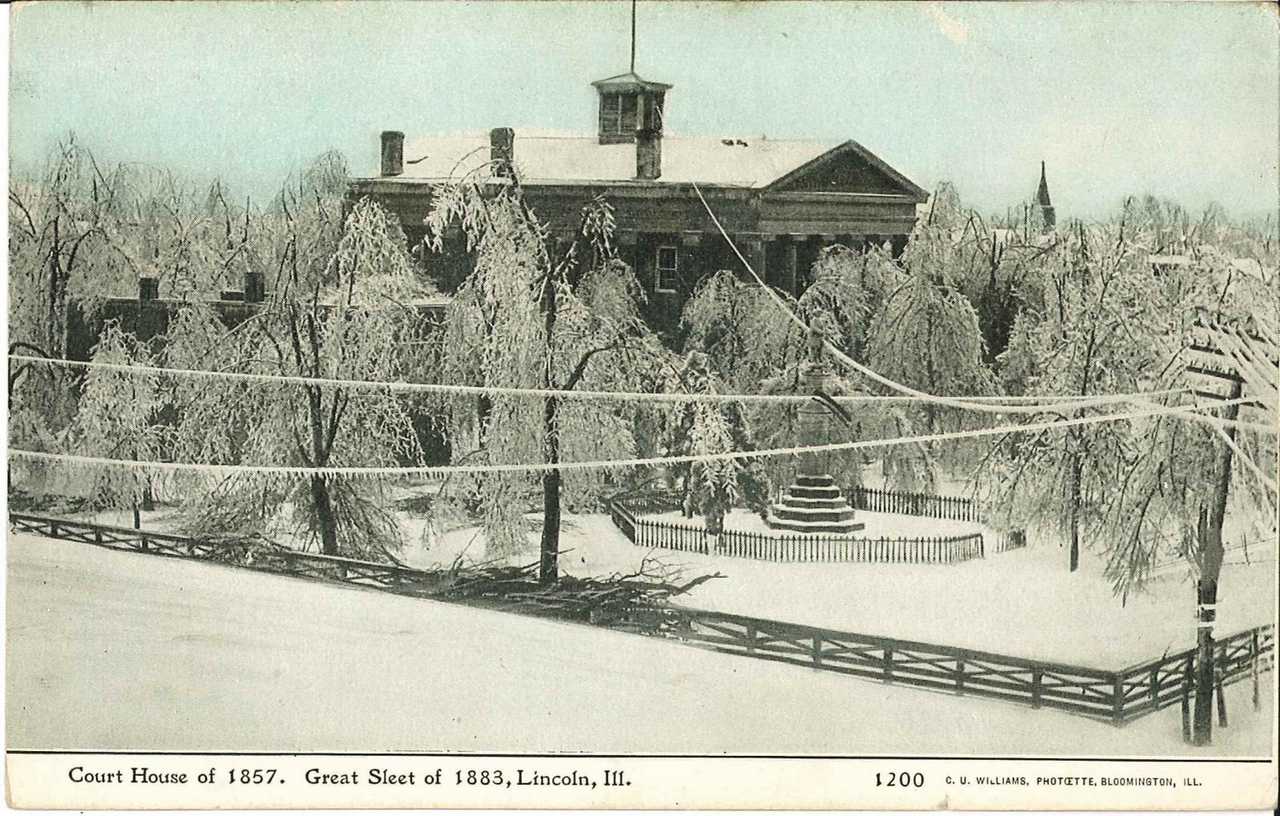
The following image was sent to us by one of the forecasters at the NWS office in Louisville, KY, of the Logan County courthouse in Lincoln during the "Great Sleet of 1883".
As Lincoln's climate records only go back to 1905, some investigation was done as to the background of this particular event.
The Army Signal Service, which was responsible for weather maps and forecasts at the time, published the following weather map from the morning of Saturday, February 3. As the theory of frontal boundaries was unknown in meteorology at the time, we have added the approximate locations of the storm system and associated warm and cold fronts. An area of low pressure was in southeast Missouri, with a warm front arcing northeast through east central Illinois and northern Indiana. Temperatures were in the 20s across central Illinois, with 30s observed along and south of the current I-70 corridor.
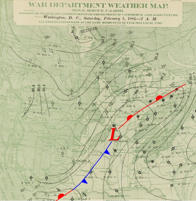
Edited surface map from February 3, 1883. Image courtesy NOAA Central Library Data Imaging Project.
The storm had been producing light snow further to the northwest. As warmer air was drawn up from the Gulf of America, the precipitation began to transition. According to the Historical Encyclopedia of Illinois, Vol. 2 (published in 1906):
"Very soon after reaching this point on the night of February 2nd, the snow, which prevailed in the regions west and north, ceased, giving place first to a kind of hard-balled snow, gradually changing to fine, dry sleet, and then to a mixture of sleet and rain, which froze solid as fast as it fell."
Observations from local weather stations indicated that scattered thunderstorms accompanied the precipitation. Some precipitation totals (rain plus melted sleet/snow) from around central and southern Illinois from this storm:
| Location | County | Feb. 2 Total |
Feb. 3 Total |
| Bunker Hill | Macoupin | 1.45" | 1.50" |
| Centralia | Marion | 2.55" (plus 1.80" on 2/1) | None |
| Griggsville | Pike | 2.62" | 0.35" |
| Mascoutah | St. Clair | N/A | 4.00" (2-day total) |
| Mattoon | Coles | 2.74" | 1.51" |
| Palestine | Crawford | 2.10" | 2.00" |
| Peoria | Peoria | 0.92" | 0.00" |
| Springfield | Sangamon | 1.94" | 2.09" |
After the storm left the area, it produced extensive rainfall over the Ohio Valley, which combined with 10 to 12 inches of melting snow to produce extensive flooding.
This mixture of sleet and freezing rain caused significant damage to trees, telephone wires, and telegraph wires. According to the Historical Encyclopedia,
"In Jacksonville and vicinity the storm, though damaging to trees, telephone and telegraph wires, was a thing of beauty. ...The telephone wires of the city were nearly all broken down by the weight of the ice, and that means of communication was almost entirely destroyed for the time."
The Illinois State Register newspaper in Springfield described the event as
"the Storm Phenomenal -- the storm before which all others pale into insignificance."
Telephone and telegraph communications were cut off, trees were leveled, and the courthouse square and Oak Ridge Cemetery were "involved in common ruin". Information in a report by the Illinois General Assembly indicated that $113.62 were allocated to one M. Doyle for "trimming and cleaning grounds of Executive Mansion, rendered necessary on account of sleet storm of February, 1883".
According to the History of Logan County, Illinois, Vol. 1 (published 1911),
"Fruit and shade trees were broken down by the mass of ice clinging to them. During the night, the almost continuous crashing of branches was heard everywhere. The dawn of day showed everything covered with a coat of ice about an inch thick. All of the telegraph wires were down with the heavy weight and nearly half of their supporting poles were snapped in twain and strewn across the roadways, in from two to six pieces. .. Two days later came the sun, which shone through the glistening boughs, with all its beauty, until the whole scene seemed like Fairyland, adorned with palaces of pearls, with domes of crystal, and forming a vista, indescribably grand."
Weather observers around the state also noted the following in their entries (published in the 1883 edition of Climatological Data):
Weather records indicated that temperatures remained below freezing for over a week, preventing the ice from melting until the 11th, when a general warming trend commenced (highs in Springfield reached 64 degrees by the 16th). By this point, there was about a foot of snow and ice on the ground, which melted and caused extensive flooding.

