Overview
|
Two consecutive days of severe storms brought widespread damaging winds, tornadoes, and isolated large hail to central Illinois between June 10-11, 2026. NWS surveys have preliminarily confirmed 12 tornadoes, including the high end EF-3 Washburn, IL tornado. |
.png) Tornado near Washburn, IL June 11th, 2026 Photo: Ben Warren |
Tornadoes
Select a tornado from the table to zoom into the track and view more information. The default table view is limited to 8 tracks, but can be scrolled by a mouse wheel or dynamically expanded. Additionally, the table can fill the entire window by clicking the small circular expanding arrow icon at the very top right of the table and returned to its original size by clicking the button again. The side information panel that opens over the map can be closed using the "X" on the upper right corner of the pop-up. Zoom into the map and click damage points to see detailed information and pictures from the surveys.
|
NOTE: times shown below are local to your device's time zone. |

The Enhanced Fujita (EF) Scale classifies tornadoes into the following categories:
| EF0 Weak 65-85 mph |
EF1 Moderate 86-110 mph |
EF2 Significant 111-135 mph |
EF3 Severe 136-165 mph |
EF4 Extreme 166-200 mph |
EF5 Catastrophic 200+ mph |
 |
|||||
| Tornadoes that fail to impact any ratable damage indicators on the EF-Scale are rated EF-Unknown (EF-U) | |||||
Photos & Video
Header
 |
 |
| Trees debarked with only stubs of largest branches remaining [Washburn] (source: NWWS Damage Survey) |
Faux log cabin style home destroyed by Washburn Tornado (source: NWS Damage Survey) |
Storm Reports
Preliminary Local Storm Report...Summary National Weather Service Lincoln IL 242 PM CDT Fri Jun 12 2026 ..TIME... ...EVENT... ...CITY LOCATION... ...LAT.LON... ..DATE... ....MAG.... ..COUNTY LOCATION..ST.. ...SOURCE.... ..REMARKS.. 0440 PM Tstm Wnd Dmg Spring Bay 40.82N 89.53W 06/11/2026 Woodford IL Public Tree blown down. 0459 PM Tornado 5 WNW Low Point 40.91N 89.40W 06/11/2026 Woodford IL Trained Spotter Social media photos showing large tornado in progress. 0513 PM Funnel Cloud 2 SW Benson 40.83N 89.15W 06/11/2026 Woodford IL Trained Spotter Trained spotter in Roanoake reported a funnel cloud looking northeast. 0515 PM Tstm Wnd Dmg Washington 40.70N 89.41W 06/11/2026 Tazewell IL Public Large tree limb blown down onto powerlines and the road. Time estimated by radar. 0518 PM Funnel Cloud 1 W Ipava 40.35N 90.35W 06/11/2026 Fulton IL Trained Spotter Rotating wall cloud producing a funnel. 0522 PM Tornado Ipava 40.35N 90.32W 06/11/2026 Fulton IL Emergency Mngr 0525 PM Hail Wenona 41.05N 89.05W 06/11/2026 E2.50 Inch Marshall IL Broadcast Media Hail just shy of tennis ball size. 0525 PM Hail 1 N Toluca 41.02N 89.13W 06/11/2026 M1.75 Inch Marshall IL Trained Spotter 0538 PM Tstm Wnd Dmg 3 E Canton 40.56N 89.98W 06/11/2026 Fulton IL Public Large tree branch broken and fell on a car. Time estimated from radar. 0540 PM Funnel Cloud 2 NW Lewistown 40.42N 90.19W 06/11/2026 Fulton IL Trained Spotter Location approximate. Spotter was at the junction of IL 97 and IL 100, looking west. Time estimated by radar. 0540 PM Tstm Wnd Gst Lewistown 40.40N 90.16W 06/11/2026 E65 MPH Fulton IL Emergency Mngr 0545 PM Tstm Wnd Dmg 2 ENE Lewistown 40.41N 90.12W 06/11/2026 Fulton IL Mesonet Several power poles snapped along Dickson Mounds Road. Time estimated by radar. 0545 PM Tstm Wnd Dmg Bryant 40.47N 90.09W 06/11/2026 Fulton IL Public Three inch tree limb blown down. 0547 PM Tstm Wnd Dmg Glasford 40.57N 89.81W 06/11/2026 Peoria IL Public Multiple large tree branches were blown down. Time estimated by radar. 0548 PM Tstm Wnd Gst Lewistown 40.40N 90.16W 06/11/2026 E70 MPH Fulton IL Emergency Mngr 0550 PM Tstm Wnd Dmg 5 SSW Trivoli 40.63N 89.93W 06/11/2026 Peoria IL Emergency Mngr 18 inch diameter tree blown down. 0555 PM Hail 3 NE Banner 40.53N 89.87W 06/11/2026 E1.00 Inch Peoria IL Public Report from mPING: Quarter (1.00 in.). 0600 PM Tstm Wnd Dmg Bartonville 40.65N 89.65W 06/11/2026 Peoria IL Public 14 inch diameter tree blown down. 0601 PM Tstm Wnd Dmg 2 ESE Pekin 40.56N 89.61W 06/11/2026 Tazewell IL Emergency Mngr [Delayed Report] - Multiple buildings sustained roof damage, including loss of shingles, metal paneling, and one instance of roof uplift. 0601 PM Tstm Wnd Dmg Pekin 40.56N 89.65W 06/11/2026 Tazewell IL Public Large tree snapped. 0601 PM Tstm Wnd Dmg Pekin 40.57N 89.64W 06/11/2026 Tazewell IL Trained Spotter Tree limbs blown down. Time estimated by radar. 0602 PM Tstm Wnd Dmg 2 E Pekin 40.57N 89.61W 06/11/2026 Tazewell IL Emergency Mngr [Delayed Report] - Several instances of six inch tree limbs broken in this area. 0602 PM Tstm Wnd Dmg 4 SE Pekin 40.54N 89.59W 06/11/2026 Tazewell IL Emergency Mngr [Delayed Report] - Two large trees were uprooted. 0603 PM Tstm Wnd Dmg 1 NNW South Pekin 40.50N 89.66W 06/11/2026 Tazewell IL Broadcast Media Six inch diameter tree limb blown down. 0603 PM Tstm Wnd Dmg 1 SE Peoria 40.71N 89.58W 06/11/2026 Peoria IL Public Large tree branches down on Glen View Ct. 0603 PM Tstm Wnd Dmg 1 E West Peoria 40.70N 89.61W 06/11/2026 Peoria IL Trained Spotter Tree limbs blown down, approximately 2 to 6 inches in diameter. Time estimate by radar. 0604 PM Tstm Wnd Dmg 1 W Peoria 40.72N 89.62W 06/11/2026 Peoria IL Trained Spotter Tree limbs blown down, four to six inches in diameter. Time estimated by radar. 0605 PM Tstm Wnd Dmg 1 SSW Marquette Heights 40.61N 89.61W 06/11/2026 Tazewell IL Emergency Mngr [Delayed Report] - Trees uprooted on Lincoln Boulevard near Everett McKinley Dirksen Park. 0605 PM Tstm Wnd Dmg Marquette Heights 40.62N 89.60W 06/11/2026 Tazewell IL Emergency Mngr [Delayed Report] - Large tree blown down onto a car. 0605 PM Tstm Wnd Dmg 1 WNW Marquette Heights 40.62N 89.62W 06/11/2026 Tazewell IL Emergency Mngr [Delayed Report] - Trees uprooted at Richard Morrissey Park. 0605 PM Tstm Wnd Dmg 2 N South Pekin 40.52N 89.66W 06/11/2026 Tazewell IL Broadcast Media Trees and power lines down on 2nd and 3rd Street. 0605 PM Tstm Wnd Dmg Havana 40.30N 90.06W 06/11/2026 Mason IL Emergency Mngr Trees down in Havana. 0605 PM Hail 2 SW Peoria Intl Airpor 40.63N 89.71W 06/11/2026 E1.00 Inch Peoria IL Public Report from mPING: Quarter (1.00 in.). 0606 PM Tstm Wnd Gst East Peoria 40.67N 89.58W 06/11/2026 M56 MPH Tazewell IL Emergency Mngr 0606 PM Tstm Wnd Gst Peoria Intl Airport 40.66N 89.69W 06/11/2026 M63 MPH Peoria IL ASOS 0607 PM Tstm Wnd Dmg Tremont 40.53N 89.49W 06/11/2026 Tazewell IL Emergency Mngr [Delayed Report] - A large tree was blown down onto a power line. 0607 PM Tstm Wnd Gst Tremont 40.53N 89.49W 06/11/2026 M57 MPH Tazewell IL Emergency Mngr 0608 PM Tstm Wnd Dmg 3 ESE East Peoria 40.65N 89.52W 06/11/2026 Tazewell IL Emergency Mngr [Delayed Report] - Power pole snapped at the base. A tree was also snapped in this area, about halfway up the trunk. Time estimated by radar. 0608 PM Tstm Wnd Dmg Groveland 40.59N 89.53W 06/11/2026 Tazewell IL Trained Spotter Power poles snapped. Time estimated by radar. 0611 PM Tstm Wnd Dmg 4 W Washington 40.71N 89.48W 06/11/2026 Tazewell IL Emergency Mngr [Delayed Report] - Multiple trees were blown down in this area. Time estimated by radar. 0611 PM Hail Pekin 40.57N 89.65W 06/11/2026 E0.75 Inch Tazewell IL Public 0611 PM Tstm Wnd Dmg Creve Coeur 40.64N 89.59W 06/11/2026 Tazewell IL Trained Spotter Tree blown down onto power lines and roadway. Time estimate by radar. 0611 PM Tstm Wnd Dmg 1 E Creve Coeur 40.64N 89.58W 06/11/2026 Tazewell IL Public Tree down on roadway. Time estimate by radar. 0612 PM Tstm Wnd Gst 1 NNW East Peoria 40.68N 89.59W 06/11/2026 E70 MPH Tazewell IL Broadcast Media 0612 PM Tstm Wnd Dmg 1 E Creve Coeur 40.64N 89.58W 06/11/2026 Tazewell IL Public Trees blown down. 0613 PM Tstm Wnd Dmg 3 NW Mackinaw 40.57N 89.40W 06/11/2026 Tazewell IL Trained Spotter Tree down blocking CR 1700N. Time estimated by radar. 0615 PM Tstm Wnd Dmg 4 E Dillon 40.47N 89.46W 06/11/2026 Tazewell IL Emergency Mngr [Delayed Report] - A tree was blown down onto a vehicle. 0615 PM Tstm Wnd Dmg 1 ESE Morton 40.60N 89.44W 06/11/2026 Tazewell IL Trained Spotter Trees snapped, approximately two feet in diameter. Other branches blown down. 0615 PM Tstm Wnd Gst 1 SSW Morton 40.60N 89.46W 06/11/2026 E70 MPH Tazewell IL CO-OP Observer Estimated 70 mph gusts with tree damage observed. 0615 PM Tstm Wnd Dmg 1 S Morton 40.60N 89.46W 06/11/2026 Tazewell IL CO-OP Observer Tree damage observed. 0616 PM Tstm Wnd Dmg 1 SSW Morton 40.60N 89.47W 06/11/2026 Tazewell IL Cocorahs Several trees blown down. Estimated 70 mph gusts. 0616 PM Tstm Wnd Gst 1 SSW Morton 40.60N 89.47W 06/11/2026 E70 MPH Tazewell IL Cocorahs 0617 PM Tstm Wnd Gst Mackinaw 40.53N 89.36W 06/11/2026 M62 MPH Tazewell IL Public Time estimated by radar. 0617 PM Tstm Wnd Dmg 1 WSW Deer Creek 40.62N 89.36W 06/11/2026 Tazewell IL Trained Spotter Semi-truck blown over, multiple vehicle in ditch. Possible tornado. Time estimated by radar. 0617 PM Tstm Wnd Dmg 3 SSW Deer Creek 40.58N 89.35W 06/11/2026 Tazewell IL Public Social media photo showing a large tree blown down onto a chain link fence. Time estimated by radar. 0619 PM Tornado 1 W Deer Creek 40.63N 89.35W 06/11/2026 Tazewell IL Trained Spotter 0620 PM Tstm Wnd Dmg 1 SE Morton 40.60N 89.45W 06/11/2026 Tazewell IL Public Large tree branches blown down, brick sign and courtyard umbrella damaged. Time estimated by radar. 0620 PM Tstm Wnd Dmg Delavan 40.37N 89.54W 06/11/2026 Tazewell IL Public A large branch was blown down onto a power line. 0621 PM Tstm Wnd Gst 3 W Washington 40.71N 89.46W 06/11/2026 E70 MPH Tazewell IL Trained Spotter 0622 PM Tstm Wnd Gst 4 E Washington 40.72N 89.34W 06/11/2026 M63 MPH Tazewell IL Public 0624 PM Tstm Wnd Gst 2 WNW Metamora 40.80N 89.40W 06/11/2026 M63 MPH Woodford IL Mesonet Personal weather station. 0624 PM Tstm Wnd Dmg 3 SE Eureka 40.69N 89.23W 06/11/2026 Woodford IL Trained Spotter Outbuilding blown over, small farm machinery blown over, large tree uprooted. Time estimated by radar. 0624 PM Tstm Wnd Dmg Metamora 40.79N 89.36W 06/11/2026 Woodford IL Trained Spotter Several branches down, some one to two feet in diameter. 0624 PM Tstm Wnd Dmg Minier 40.43N 89.31W 06/11/2026 Tazewell IL Emergency Mngr [Delayed Report] - A tree limb was blown down onto a vehicle. Time estimated by radar. 0624 PM Tstm Wnd Gst Mason City 40.20N 89.70W 06/11/2026 E75 MPH Mason IL Trained Spotter 0624 PM Tstm Wnd Dmg Mason City 40.20N 89.70W 06/11/2026 Mason IL Trained Spotter Sporadic tree damage. 0624 PM Tstm Wnd Dmg 1 W Mason City 40.20N 89.72W 06/11/2026 Mason IL Trained Spotter Large tree down just west of Mason City near Route 10 and Route 29. Tree is approximately two feet in diameter. 0625 PM Tstm Wnd Dmg Armington 40.34N 89.31W 06/11/2026 Tazewell IL Public Large tree down. 0630 PM Tstm Wnd Gst 1 SW Eureka 40.71N 89.29W 06/11/2026 M60 MPH Woodford IL Emergency Mngr 0630 PM Tstm Wnd Dmg Carlock 40.58N 89.13W 06/11/2026 McLean IL Emergency Mngr Large tree limbs, two feet in diameter or greater, blown down onto house resulting in structural damage. Time estimated by radar. 0633 PM Tstm Wnd Dmg 2 S El Paso 40.71N 89.02W 06/11/2026 Woodford IL Broadcast Media Grain bin destroyed south of El Paso. Time estimated by radar. 0635 PM Tstm Wnd Dmg Pleasant Plains 39.87N 89.92W 06/11/2026 Sangamon IL Fire Dept/Rescue Large tree blown down onto powerlines. Time estimated by radar. 0635 PM Tstm Wnd Dmg 1 NW Bloomington 40.50N 89.01W 06/11/2026 McLean IL Public Multiple tree limbs blown down, one approximately six inches in diameter. 0637 PM Tstm Wnd Dmg Atlanta 40.26N 89.23W 06/11/2026 Logan IL Emergency Mngr Power lines blown down. 0639 PM Tstm Wnd Dmg 1 WNW Normal 40.51N 89.00W 06/11/2026 McLean IL Trained Spotter two large tree branches broken. 0639 PM Tstm Wnd Dmg 3 SSW Bloomington 40.44N 89.02W 06/11/2026 McLean IL NWS Employee A semi-truck was blown over near the I-74/I-55 interchange. Time estimated by radar. 0640 PM Tstm Wnd Dmg 3 SE East Peoria 40.64N 89.55W 06/11/2026 Tazewell IL Public downed tree took down a power line and has the road blocked. 0640 PM Tstm Wnd Dmg Bloomington 40.48N 88.99W 06/11/2026 McLean IL Public Large tree down near the old courthouse. 0640 PM Tstm Wnd Dmg 1 ENE Bloomington 40.48N 88.98W 06/11/2026 McLean IL Public Large tree fell on an apartment building on Clinton St. 0640 PM Tstm Wnd Dmg Normal 40.51N 88.99W 06/11/2026 McLean IL Public Social media photo showing a very large tree blown down (4 to 5 feet in diameter). Time estimated by radar. 0640 PM Tstm Wnd Dmg Bloomington 40.48N 88.99W 06/11/2026 McLean IL Public Two large trees uprooted, and a large tree limb blown down onto the road. 0640 PM Tstm Wnd Dmg 1 NNW Lincoln 40.16N 89.37W 06/11/2026 Logan IL NWS Employee large tree down over roadway. time estimated from radar. 0640 PM Tstm Wnd Dmg 1 W Lincoln 40.15N 89.37W 06/11/2026 Logan IL Public large tree down over roadway. time estimated from radar. 0640 PM Tstm Wnd Dmg Lincoln 40.15N 89.36W 06/11/2026 Logan IL Emergency Mngr Power lines down. 0640 PM Tstm Wnd Dmg NWS Lincoln 40.15N 89.34W 06/11/2026 Logan IL NWS Employee A tree was uprooted on the south side of the NWS Lincoln building. 0640 PM Tstm Wnd Dmg 1 NNW Lincoln 40.16N 89.38W 06/11/2026 Logan IL NWS Employee Large tree branch down onto a fence. 0640 PM Tstm Wnd Dmg Lincoln 40.15N 89.36W 06/11/2026 Logan IL Public Social media photo shows a large tree limb, approximately two feet in diameter, fell onto a house resulting in structural damage to a porch covering. Time estimated by radar. 0641 PM Tstm Wnd Dmg 2 WNW Central Illinois 40.49N 88.94W 06/11/2026 McLean IL Public Tree snapped near base, approximately one foot in diameter. 0642 PM Tstm Wnd Gst Central Illinois Airpor 40.48N 88.91W 06/11/2026 M59 MPH McLean IL AWOS 0644 PM Tstm Wnd Dmg 2 NW Central Illinois A 40.50N 88.94W 06/11/2026 McLean IL Public Tree uprooted on north Hershey Road just before Rainbow Avenue. Time estimated by radar. 0644 PM Tstm Wnd Dmg 2 W Central Illinois Ai 40.48N 88.95W 06/11/2026 McLean IL Public Social media video shows a large tree split in half. Time estimated by radar. 0645 PM Tstm Wnd Dmg Waynesville 40.24N 89.13W 06/11/2026 De Witt IL Emergency Mngr Two power poles broken. Time estimated by radar. 0650 PM Tstm Wnd Dmg Lexington 40.64N 88.78W 06/11/2026 McLean IL Public Social media photo showing a tree blown down. Time estimated by radar. 0650 PM Tstm Wnd Dmg 7 E Bloomington 40.48N 88.86W 06/11/2026 McLean IL Public Tree snapped about halfway up the base. Approximately one to two feet in diameter. Time estimated by radar. 0650 PM Tstm Wnd Dmg Wapella 40.22N 88.96W 06/11/2026 De Witt IL Emergency Mngr Power line blown down, resulting in a fire in an alley. Time estimated by radar. 0650 PM Tstm Wnd Dmg Hallsville 40.15N 89.09W 06/11/2026 De Witt IL Emergency Mngr Tree blown down across roadway. 0650 PM Tstm Wnd Dmg 4 SSW Heyworth 40.27N 89.01W 06/11/2026 De Witt IL Emergency Mngr Tree and power lines blown down. 0652 PM Tstm Wnd Dmg Clinton 40.16N 88.97W 06/11/2026 De Witt IL Emergency Mngr Tree limbs down onto a house, resulting in damage to the fascia and siding. Time estimated by radar. 0653 PM Flash Flood Delavan 40.37N 89.54W 06/11/2026 Tazewell IL Emergency Mngr 6 inches of water flowing over Rt 122. 0653 PM Tstm Wnd Dmg Kenney 40.10N 89.08W 06/11/2026 De Witt IL Emergency Mngr Power lines blown down on Kenney Street. 0653 PM Tstm Wnd Dmg Clinton 40.15N 88.95W 06/11/2026 De Witt IL Trained Spotter Tree down blocking Highway 54. 0654 PM Tstm Wnd Dmg Virginia 39.95N 90.21W 06/11/2026 Cass IL Trained Spotter Tree down across Bardon Street. 0657 PM Tstm Wnd Dmg Le Roy 40.35N 88.76W 06/11/2026 McLean IL Public Large tree snapped about halfway up the base. The tree was approximately two to three feet in diameter. Time estimated by radar. A nearby personal weather station measured a 78 mph gust. 0658 PM Tstm Wnd Gst 3 SW Chestnut 40.02N 89.22W 06/11/2026 M70 MPH Logan IL Trained Spotter Report relayed by county EM. 0700 PM Tstm Wnd Gst Le Roy 40.35N 88.77W 06/11/2026 M78 MPH McLean IL Mesonet Personal weather station. 0700 PM Tstm Wnd Gst Latham 39.97N 89.16W 06/11/2026 E75 MPH Logan IL Emergency Mngr 0703 PM Tstm Wnd Dmg 3 ESE Jacksonville 39.72N 90.18W 06/11/2026 Morgan IL Public Delayed report. 3 inch tree limbs down. 20 pound aluminum fenders blown around the truck yard. 0705 PM Tstm Wnd Dmg Farmer City 40.25N 88.65W 06/11/2026 De Witt IL Emergency Mngr Tree blown down blocking roadway in Farmer City. Time estimated by radar. 0706 PM Tstm Wnd Dmg Bellflower 40.34N 88.53W 06/11/2026 McLean IL Public A few four inch diameter tree limbs were blown down onto the front porch of a house. Time estimated by radar. 0706 PM Tstm Wnd Dmg Saybrook 40.43N 88.53W 06/11/2026 McLean IL Emergency Mngr Tree limbs blown down. 0706 PM Tstm Wnd Gst Saybrook 40.43N 88.53W 06/11/2026 E60 MPH McLean IL Emergency Mngr 0706 PM Tstm Wnd Dmg 2 E De Witt 40.18N 88.74W 06/11/2026 De Witt IL Emergency Mngr Tree blown down blocking Route 48. 0709 PM Tstm Wnd Dmg 1 N Bellflower 40.35N 88.53W 06/11/2026 McLean IL Emergency Mngr Power poles blown down blocking the road. 0709 PM Tstm Wnd Dmg Argenta 39.99N 88.81W 06/11/2026 Macon IL Public Trees down on Broadway Street. Time estimated by radar. 0710 PM Tstm Wnd Dmg Lodge 40.11N 88.56W 06/11/2026 Piatt IL Public A tree was blown down. Time estimated by radar. 0710 PM Flash Flood 4 SSE NWS Lincoln 40.09N 89.31W 06/11/2026 Logan IL Emergency Mngr Route 121 and 1200th Street completely flooded with water flowing over the roadway. 0715 PM Tstm Wnd Dmg Monticello 40.03N 88.57W 06/11/2026 Piatt IL Public Social media photo shows tree blown down onto chain link fence, destroying the fence. Time estimated by radar. 0715 PM Tstm Wnd Dmg White Heath 40.09N 88.51W 06/11/2026 Piatt IL Public Social media photo shows multiple large tree limbs (12 to 18 inches in diameter) blown down onto power lines and a truck, damaging the vehicle. Time estimated by radar. 0715 PM Tstm Wnd Dmg 1 NNE White Heath 40.10N 88.51W 06/11/2026 Piatt IL Public Social media photo showing multiple large tree limbs down onto a vehicle. Time estimated by radar. 0715 PM Tstm Wnd Dmg 3 S Mansfield 40.17N 88.52W 06/11/2026 Piatt IL Public Wooden outdoor playset was destroyed. Time estimated by radar. 0715 PM Tstm Wnd Dmg Monticello 40.03N 88.57W 06/11/2026 Piatt IL Emergency Mngr Extensive tree damage across Monticello. Several streets blocked, power poles also damage. 0719 PM Tstm Wnd Dmg 3 N Rossville 40.42N 87.67W 06/11/2026 Vermilion IL Public Social media photo shows a short tree snapped near the base, which was approximately one foot in diameter. Time estimated by radar. 0719 PM Tstm Wnd Dmg Seymour 40.11N 88.43W 06/11/2026 Champaign IL Public Large tree branch blown down. Time estimated by radar. 0719 PM Tstm Wnd Dmg 3 SSW Mahomet 40.16N 88.43W 06/11/2026 Champaign IL Emergency Mngr Power lines down at intersection of 1900N and 200E. 0720 PM Funnel Cloud Rossville 40.38N 87.66W 06/11/2026 Vermilion IL Trained Spotter Report relayed by county EM. 0720 PM Tstm Wnd Gst 1 N Farmingdale 39.84N 89.81W 06/11/2026 E60 MPH Sangamon IL Emergency Mngr Estimated gusts of 50-60 mph. 0720 PM Tstm Wnd Dmg 3 NE Fisher 40.35N 88.32W 06/11/2026 Champaign IL Public 0720 PM Tstm Wnd Gst 2 WNW Seymour 40.12N 88.46W 06/11/2026 E60 MPH Champaign IL Trained Spotter Estimating 55-60 mph gusts. Report relayed by county EM. 0722 PM Tstm Wnd Gst 2 NNE Curran 39.77N 89.75W 06/11/2026 M60 MPH Sangamon IL Mesonet Personal weather station. 0722 PM Tstm Wnd Dmg 3 NNE Champaign 40.15N 88.24W 06/11/2026 Champaign IL Broadcast Media Damage to the roof of a large apartment complex, with numerous chunks of shingles pulled up or removed. Possible tornado. Time estimated by radar. 0722 PM Tstm Wnd Dmg 3 NNE Champaign 40.15N 88.25W 06/11/2026 Champaign IL Public Damage reported in the Ashland Park neighborhood, including signs bent over. Possible tornado. Time estimated by radar. 0723 PM Tstm Wnd Dmg 2 N Champaign 40.14N 88.27W 06/11/2026 Champaign IL Broadcast Media Social media photo shows roofing damage to a large apartment complex north of I-74 and west of Prospect Avenue. Time estimated by radar. Possible tornado. 0723 PM Tstm Wnd Dmg 3 WSW Champaign 40.10N 88.31W 06/11/2026 Champaign IL Public Social media photo shows a large tree, approximately two feet in diameter, blown onto a wooden fence. Time estimated by radar. 0725 PM Tstm Wnd Dmg 3 ENE Ludlow 40.40N 88.08W 06/11/2026 Champaign IL Public Delayed report. Time estimated from radar. 72 by 80 machine shed lost sliding door and part of roof which hit a solar array. Large tree branches were down. Small outbuildings heavily damaged. 0725 PM Tstm Wnd Dmg Rantoul 40.31N 88.15W 06/11/2026 Champaign IL Public Photo of a large tree limb more than a foot in diameter that was snapped. 0725 PM Tstm Wnd Dmg 3 NNW Urbana 40.15N 88.22W 06/11/2026 Champaign IL Public Social media photo showing multiple tree limbs down, some of which fell onto vehicles. Time estimated by radar. Possible tornado. 0725 PM Tstm Wnd Dmg 2 NE Champaign 40.13N 88.24W 06/11/2026 Champaign IL Public A large tree was blown down and landed on top of a car. 0725 PM Tstm Wnd Dmg 1 SE Champaign 40.10N 88.25W 06/11/2026 Champaign IL Public Trees blown down at Hessel Park. Time estimated by radar. 0726 PM Tstm Wnd Dmg 1 WNW Champaign 40.12N 88.27W 06/11/2026 Champaign IL Public Tree blown down at corner of Victor Street and Park Avenue. Time estimated by radar. 0726 PM Tstm Wnd Dmg 1 SSE Champaign 40.10N 88.26W 06/11/2026 Champaign IL Broadcast Media Numerous trees down across Champaign, including one blocking Prospect Avenue. Time estimated by radar. 0726 PM Tstm Wnd Dmg 3 NNE Urbana 40.15N 88.19W 06/11/2026 Champaign IL Public Roof damage to a store on north Cunningham Avenue. Time estimated by radar. Possible tornado. 0726 PM Tstm Wnd Dmg 1 SW Champaign 40.10N 88.28W 06/11/2026 Champaign IL Public Power pole bent near Centennial Park. 0726 PM Tstm Wnd Dmg Thomasboro 40.24N 88.18W 06/11/2026 Champaign IL Emergency Mngr Large tree blown down and portions of a wooden fence also blown over. 0726 PM Tstm Wnd Dmg 3 N Champaign 40.16N 88.28W 06/11/2026 Champaign IL Broadcast Media Radio tower collapsed. Time estimated by radar. 0728 PM Tstm Wnd Dmg 1 NW Rantoul 40.32N 88.17W 06/11/2026 Champaign IL Public Six power poles snapped west of Rantoul. Time estimated by radar. 0728 PM Tstm Wnd Gst 3 S Urbana 40.07N 88.21W 06/11/2026 M61 MPH Champaign IL Trained Spotter 0729 PM Tstm Wnd Dmg Chatham 39.68N 89.70W 06/11/2026 Sangamon IL NWS Employee Delayed report. Large limbs down at intersection of East Walnut and Sherry and on N East Street just south of Walnut. Time estimated from radar. 0729 PM Tstm Wnd Dmg Savoy 40.06N 88.25W 06/11/2026 Champaign IL Public Part of a tree was blown down. Time estimated by radar. 0729 PM Tstm Wnd Dmg 1 SSE Urbana 40.09N 88.20W 06/11/2026 Champaign IL Public Numerous trees down onto a house. Time estimated by radar. 0729 PM Tstm Wnd Dmg 1 W Rantoul 40.30N 88.17W 06/11/2026 Champaign IL Public Large tree limb blown down blocking part of Murray Road. Time estimated by radar. 0730 PM Tstm Wnd Dmg 2 NW Leland Grove 39.80N 89.72W 06/11/2026 Sangamon IL Emergency Mngr Tree damage noted on the west side of Springfield. 0730 PM Tstm Wnd Dmg Jacksonville 39.73N 90.23W 06/11/2026 Morgan IL Emergency Mngr Trees blown down onto houses and roadways. 0730 PM Rain Athens 39.96N 89.72W 06/11/2026 M1.57 Inch Menard IL Cocorahs Amount occurred in 50 minutes. 0730 PM Tstm Wnd Dmg Rantoul 40.31N 88.16W 06/11/2026 Champaign IL Public Social media photo showing a tree limb through the roof of a house. The house also has damage to its siding. Time estimated by radar. 0730 PM Tstm Wnd Dmg 1 W Willard Airport 40.04N 88.29W 06/11/2026 Champaign IL Public Several tree limbs blown down west of Willard Airport. Time estimated by radar. 0730 PM Tstm Wnd Dmg 3 N Champaign 40.15N 88.27W 06/11/2026 Champaign IL Public Damage to the side of a warehouse and two powerlines were snapped. Other small outdoor objects scattered around. 0730 PM Tstm Wnd Dmg Tolono 39.99N 88.26W 06/11/2026 Champaign IL Fire Dept/Rescue Numerous trees and limbs blown down all over Tolono, but no property damage reported. Time estimated by radar. 0731 PM Tstm Wnd Gst Willard Airport 40.04N 88.28W 06/11/2026 M68 MPH Champaign IL ASOS 0733 PM Tstm Wnd Gst 1 WNW Springfield 39.81N 89.67W 06/11/2026 E60 MPH Sangamon IL Local Official 0733 PM Tstm Wnd Dmg Champaign 40.11N 88.26W 06/11/2026 Champaign IL Broadcast Media Webcam photo showing damage at the top of a tall building. 0735 PM Tstm Wnd Gst Capital Airport 39.84N 89.68W 06/11/2026 M68 MPH Sangamon IL ASOS 0735 PM Tstm Wnd Dmg 2 E Southern View 39.74N 89.62W 06/11/2026 Sangamon IL Public Numerous tree branches and a few trees blown down, some blocking roadways. 0735 PM Tstm Wnd Dmg Philo 40.01N 88.16W 06/11/2026 Champaign IL Public Social media photo showing a tree blown down near St. Thomas School in Philo. Time estimated by radar. 0735 PM Tstm Wnd Dmg 1 N Philo 40.02N 88.16W 06/11/2026 Champaign IL Public Several tree limbs blown down. Time estimated by radar. 0735 PM Tstm Wnd Dmg 1 ENE Tolono 39.99N 88.25W 06/11/2026 Champaign IL Trained Spotter Large tree branches blown down. 0737 PM Tstm Wnd Dmg 1 SW Jerome 39.76N 89.69W 06/11/2026 Sangamon IL Public Several tree branches blown down. 0739 PM Funnel Cloud Oakwood 40.12N 87.78W 06/11/2026 Vermilion IL Trained Spotter Funnel cloud on the southern edge of the storm. 0739 PM Tstm Wnd Dmg Ogden 40.11N 87.96W 06/11/2026 Champaign IL Public Large tree limbs blown down in Ogden. Time estimated by radar. 0740 PM Tstm Wnd Dmg Mechanicsburg 39.81N 89.40W 06/11/2026 Sangamon IL Emergency Mngr Tree blown down onto power line. Time estimated by radar. 0740 PM Tstm Wnd Gst Warrensburg 39.93N 89.06W 06/11/2026 E60 MPH Macon IL Emergency Mngr 0742 PM Tstm Wnd Dmg 1 N Fithian 40.13N 87.87W 06/11/2026 Vermilion IL Emergency Mngr Structural damage north of Fithian. Possible tornado. Time estimated by radar. 0742 PM Tstm Wnd Dmg 1 E Springfield 39.80N 89.63W 06/11/2026 Sangamon IL Broadcast Media large portion of a tree broken off at Comer Cox Park. 0742 PM Tstm Wnd Dmg 2 SSE Grandview 39.79N 89.61W 06/11/2026 Sangamon IL Public Large tree limb blown down onto house. Time estimated by radar. 0742 PM Tstm Wnd Dmg Springfield 39.80N 89.65W 06/11/2026 Sangamon IL Public Social media photo shows part of a large tree blown down onto the hood of a car near the Abraham Lincoln Historical Home. Time estimated by radar. 0745 PM Tstm Wnd Dmg 1 SW Hoopeston 40.45N 87.69W 06/11/2026 Vermilion IL Public Business has a hole in its roof as the result of the storms. Possible tornado. Time estimated by radar. 0745 PM Tstm Wnd Gst 1 N Collison 40.24N 87.80W 06/11/2026 M66 MPH Vermilion IL Mesonet Personal weather station. 0746 PM Tstm Wnd Dmg 3 N Oakwood 40.15N 87.77W 06/11/2026 Vermilion IL Public Social media photo showing a large tree down just off Newtown Road north of Oakwood. Possible tornado. Time estimated by radar. 0746 PM Tstm Wnd Gst 4 SW Henning 40.26N 87.75W 06/11/2026 E75 MPH Vermilion IL Trained Spotter 0747 PM Tstm Wnd Dmg 1 SE Hoopeston 40.46N 87.66W 06/11/2026 Vermilion IL Emergency Mngr metal debris blown into high school softball field fencing. Metal bleachers pushed 10 to 20 feet onto the field. 0747 PM Tornado 1 S Hoopeston 40.45N 87.67W 06/11/2026 Vermilion IL Trained Spotter Tornado reported south of Hoopeston. Report relayed by county EM. 0747 PM Tstm Wnd Dmg 1 SE Hoopeston 40.46N 87.66W 06/11/2026 Vermilion IL Trained Spotter Damage occurred to small outbuildings near the high school with debris strewn through the field. Possible tornado. 0748 PM Tstm Wnd Dmg 2 NE Oakwood 40.14N 87.75W 06/11/2026 Vermilion IL Public Social media photo shows numerous trees blown down onto a road in Kickapoo State Park northeast of Oakwood. Possible tornado. Time estimated by radar. 0748 PM Tstm Wnd Dmg 2 N Oakwood 40.15N 87.77W 06/11/2026 Vermilion IL Public Social media photo shows a power pole snapped northeast of Oakwood. Possible tornado. Time estimated by radar. 0750 PM Hail 2 E Decatur 39.84N 88.91W 06/11/2026 M0.75 Inch Macon IL Public Report from mPING: Dime (0.75 in.). 0752 PM Tstm Wnd Dmg 1 WSW Decatur 39.84N 88.98W 06/11/2026 Macon IL Public Social media photo showing a large tree limb blown down onto Main Street. Time estimated by radar. 0753 PM Tstm Wnd Dmg 1 W Danville 40.14N 87.64W 06/11/2026 Vermilion IL Public Delayed report. Large tree fell onto a house near Lincoln Park. Time estimated from radar. 0753 PM Tstm Wnd Gst 2 N Danville 40.17N 87.64W 06/11/2026 M65 MPH Vermilion IL Emergency Mngr 0753 PM Tstm Wnd Dmg 4 E Hoopeston 40.46N 87.59W 06/11/2026 Vermilion IL Emergency Mngr Heavy damage to a farm business on IL-9 just west of the IL-IN state line. Possible tornado. 0754 PM Tstm Wnd Dmg Bismarck 40.26N 87.61W 06/11/2026 Vermilion IL Public A tree was blown down. Time estimated by radar. 0754 PM Tstm Wnd Dmg 1 NW Danville 40.15N 87.65W 06/11/2026 Vermilion IL Public Tree blown onto house. Time estimated by radar. 0754 PM Tstm Wnd Dmg 2 W Danville 40.14N 87.67W 06/11/2026 Vermilion IL Emergency Mngr Two large trees blown down. 0754 PM Tstm Wnd Dmg Macon 39.71N 89.00W 06/11/2026 Macon IL Public Social media photo showing several tree limbs blown down onto a vehicle. Time estimated by radar. 0755 PM Tstm Wnd Dmg 2 SSE Danville 40.12N 87.62W 06/11/2026 Vermilion IL Public Social media photo showing large tree uprooted near the intersection of Buchanan and Perryville. Time estimated by radar. 0755 PM Tstm Wnd Dmg 1 NNE Tilton 40.10N 87.64W 06/11/2026 Vermilion IL Emergency Mngr Multiple trees down along the I-74 corridor through Vermilion County. Some power lines also blown down. 0756 PM Tstm Wnd Dmg 4 SE Vermilion Regional 40.16N 87.54W 06/11/2026 Vermilion IL Public Social media photo showing a large tree blown down onto a structure. Possible tornado. Time estimated by radar. 0757 PM Tstm Wnd Dmg 2 ESE Danville 40.13N 87.59W 06/11/2026 Vermilion IL Emergency Mngr Roof damage to school on the east side of Danville. Time estimated by radar. 0800 PM Tstm Wnd Dmg Georgetown 39.98N 87.63W 06/11/2026 Vermilion IL Public Social media photo of a large tree limb blown down. Time estimated by radar. 0805 PM Tstm Wnd Gst 2 E Mansfield 40.21N 88.46W 06/11/2026 M55 MPH Champaign IL Emergency Mngr 0810 PM Tstm Wnd Dmg 1 NNW Tuscola 39.81N 88.29W 06/11/2026 Douglas IL Public Tree limb down onto a house, breaking the sunroof. Limbs also down onto a vehicle at this location. Time estimated by radar. 0810 PM Tstm Wnd Dmg Tuscola 39.80N 88.29W 06/11/2026 Douglas IL Public Tree blown down into an alleyway. Time estimated by radar. 0827 PM Tstm Wnd Gst Arcola 39.68N 88.31W 06/11/2026 E60 MPH Douglas IL Trained Spotter 0827 PM Tstm Wnd Dmg Arcola 39.68N 88.31W 06/11/2026 Douglas IL Trained Spotter Shingle damage from thunderstorm winds. 0830 PM Tstm Wnd Dmg 3 WNW Hindsboro 39.70N 88.19W 06/11/2026 Douglas IL Emergency Mngr Trees and powerlines down on West Kemp Street. Time estimated by radar. 0830 PM Tstm Wnd Dmg Edinburg 39.66N 89.39W 06/11/2026 Christian IL Broadcast Media Trees blown down. Time estimated by radar. 0834 PM Tstm Wnd Dmg 1 E Taylorville 39.55N 89.28W 06/11/2026 Christian IL Public 20 foot tall tree blown over into roadway. 0840 PM Rain Waynesville 40.24N 89.13W 06/11/2026 M1.75 Inch De Witt IL Emergency Mngr 0840 PM Tstm Wnd Gst Stonington 39.64N 89.19W 06/11/2026 E60 MPH Christian IL NWS Employee 0848 PM Tstm Wnd Gst 4 SSW Mount Zion 39.72N 88.90W 06/11/2026 M61 MPH Macon IL Mesonet Personal weather station. 0850 PM Tstm Wnd Gst 1 E Bethany 39.64N 88.72W 06/11/2026 E70 MPH Moultrie IL Public 0850 PM Tstm Wnd Dmg 1 E Bethany 39.65N 88.72W 06/11/2026 Moultrie IL Public Sheet metal blown off the roof of an outbuilding. 0854 PM Tstm Wnd Dmg Paris 39.62N 87.69W 06/11/2026 Edgar IL Public Three to six inch diameter tree limbs blown down. Time estimated by radar. 0905 PM Tstm Wnd Dmg Sullivan 39.60N 88.61W 06/11/2026 Moultrie IL Public Tree limbs blown down onto power lines. Time estimated by radar. 0905 PM Tstm Wnd Dmg Arthur 39.72N 88.47W 06/11/2026 Douglas IL Public Powerlines blown down near Arthur. 0910 PM Tstm Wnd Dmg Chesterville 39.70N 88.39W 06/11/2026 Douglas IL Public One healthy tree blown down, and three additional large tree limbs also blown down. 0911 PM Tstm Wnd Gst 3 ENE Arcola 39.70N 88.25W 06/11/2026 M75 MPH Douglas IL Mesonet Personal weather station. 0919 PM Tstm Wnd Dmg Mattoon 39.48N 88.37W 06/11/2026 Coles IL Broadcast Media Tree damage in Mattoon. 0929 PM Tstm Wnd Gst 3 NNE Broadlands 39.95N 87.97W 06/11/2026 M61 MPH Champaign IL Mesonet Personal weather station. 1001 PM Tstm Wnd Dmg Kansas 39.55N 87.94W 06/11/2026 Edgar IL Broadcast Media Tree damage in Kansas, and a garage with structural damage. Time estimated by radar. 1005 PM Rain 2 W Decatur 39.84N 88.99W 06/11/2026 M1.50 Inch Macon IL Mesonet SWOP report. 1020 PM Rain Harristown 39.84N 89.08W 06/11/2026 M2.27 Inch Macon IL Mesonet SWOP report. 1030 PM Rain 2 NW Lovington 39.73N 88.66W 06/11/2026 M1.14 Inch Moultrie IL Mesonet Mesonet station WORI2 2.0 NW Lovington. 1035 PM Rain Jacksonville Airport 39.77N 90.24W 06/11/2026 M1.03 Inch Morgan IL AWOS AWOS station KIJX Jacksonville Arpt. 1045 PM Rain 3 NNE Ashland 39.92N 89.99W 06/11/2026 M1.00 Inch Menard IL Mesonet Mesonet station EW7786 Tallula. 1050 PM Rain 1 WNW Bluff Springs 40.00N 90.37W 06/11/2026 M1.38 Inch Cass IL Mesonet Mesonet station FW8184 Beardstown.
Radar
Header
| Caption | Caption | Caption | Caption |
Environment
June 11, 2026
A strong storm system interacted with a highly unstable and sheared environment to produce a significant severe weather outbreak across central Illinois during the late afternoon and evening of June 11th. Scattered supercell thunderstorms initially developed west of the I-55 corridor along a pre-frontal trough during the afternoon. One of these storms produced a tornado that impacted portions of Woodford and Marshall counties and dropped golf ball-sized hail (1.75" diameter). Additional cells rapidly developed further west across southeastern Iowa into northern Missouri ahead of an advancing cold front. These storms congealed into a line and pushed eastward into central Illinois during the evening. Widespread damaging wind gusts of 60-70mph occurred with the line along and north of the I-72 corridor. In addition, a couple tornadoes were embedded within the line, creating pockets of enhanced damage.
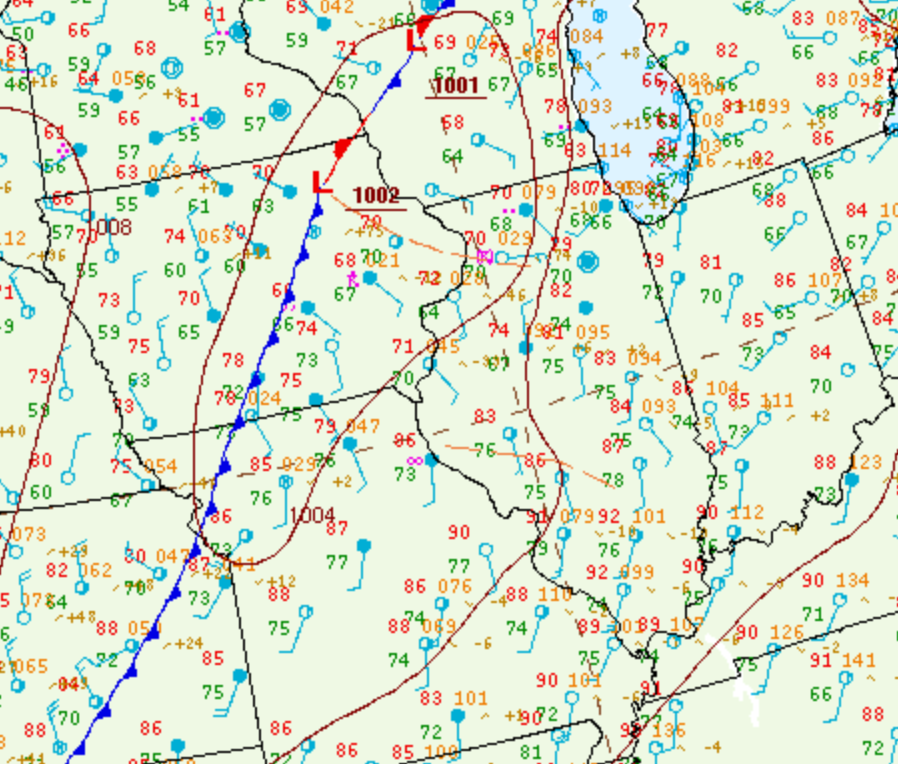
Surface analysis from the afternoon of June 11th revealed a warm and very humid airmass across central Illinois with temperatures well into the 80s and dewpoints in the middle to upper 70s. A cold front stretched from western Wisconsin southwestward to near Kansas City, while an outflow boundary from early morning convection was evident from southeastern Iowa into north-central Illinois. A vigorous short-wave trough spinning over the Northern Plains was tracking eastward and providing increased synoptic lift over the cold front.
 |
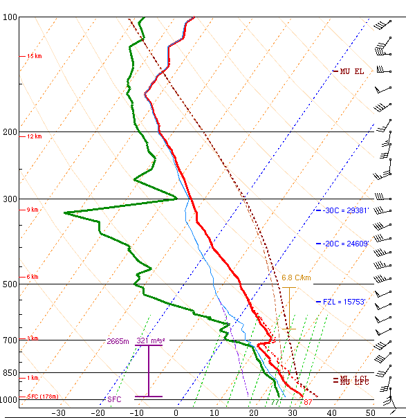 |
| Figure 1: 18z Surface Chart | Figure 2: 21z KILX Upper Air Sounding |
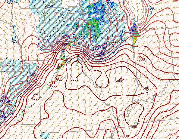
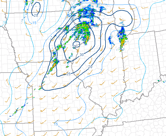
NWS Lincoln conducted two special upper air balloon launches during the afternoon of June 11th in support of the impending severe weather. The second sounding at 4pm showed extreme instability with Surface Based Convective Available Potential Energy (SBCAPE) in excess of 5000J/kg. Deep-layer shear was on the increase ahead of the approaching short-wave trough as shown by 0-6km values of 46kt. At the same time, shear in the lowest 0-1km layer was a robust 25kt. The wind profile showed both directional and speed shear as 10-15kt southeasterly surface winds veered to southwesterly and increased to 50kt at 10,000ft aloft. 2PM CDT mesoanalysis from the Storm Prediction Center (SPC) highlighted the reservoir of SBCAPES in excess of 5000J/kg across central and southern Illinois, while maintaining a much more stable airmass north of the remnant outflow boundary from Burlington, Iowa to Lacon, Illinois. Meanwhile low-level shear was greatest near the boundary as evidenced by 0-1km values greater than 25kt along and west of the Illinois River. At this time, there was a growing concern for potentially strong tornadoes where the strongest instability/shear co-existed during the late afternoon into the early evening. The 2PM CDT Significant Tornado Parameter (STP) was subsequently maximized along the southern periphery of the outflow boundary from southeastern Iowa to near Lincoln. RAP forecasts consistently showed the STP maxima shifting northward as the outflow boundary lifted toward I-80 later in the day. This provided growing confidence in the initial strong tornado forecast highlighting locations along and north of a Macomb to Bloomington line.
 |
 |
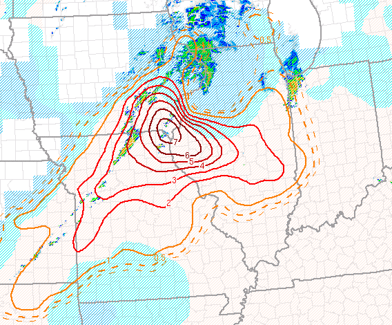 |
| Figure 4: 19z CAPE | Figure 5: 19z 0-1km Shear | Figure 6: 19z Significant Tornado Parameter |
 |
Media use of NWS Web News Stories is encouraged! Please acknowledge the NWS as the source of any news information accessed from this site. |
|

