Overview
|
A blizzard struck during the end of the Thanksgiving holiday weekend. Extending from the central Plains to the Chicago area, it caused the closure of several Interstates in Kansas, Missouri, Iowa, and Illinois during the peak of the storm. A broad area received 8 to 15 inches of snow, and wind gusts over 45 mph resulted in whiteout conditions in open areas due to blowing snow. In central Illinois, rain began to change to snow west of the Illinois River by mid to late afternoon, with the change occurring further east later in the evening. The snow was accompanied by thunder at times. As the main low pressure area moved over the middle of the state, locations just south of it also observed thunderstorms with strong winds. A funnel cloud was even reported near the St. Louis area, resulting in the rare occurrence of a Tornado Warning and a Blizzard Warning in very close proximity to each other. |
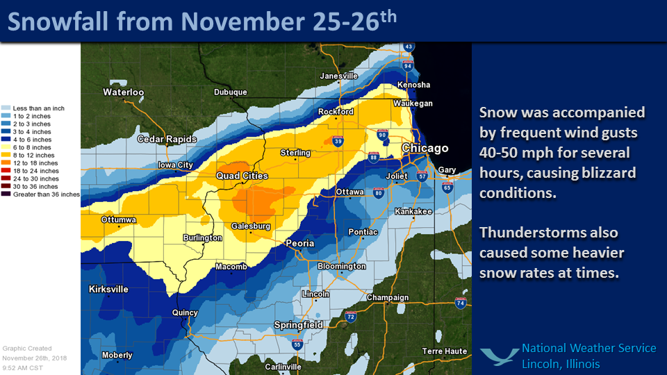 24-hour snowfall ending 7 am, 11/25/2018 |
Wind:
Strong winds occurred by late afternoon west of the Illinois River, on the west side of the low center (which moved through central Illinois). These strong winds spread across areas west of I-55 in the evening, and east of there overnight. Many gusts of 40 to 45 mph occurred, with some gusts in excess of 50 mph.
Location                     Speed     Time/Date       Provider

...Champaign County...
U of IL Willard AP           55 MPH    0553 AM 11/26   ASOS
2 SSE Urbana                 52 MPH    0630 AM 11/26   CWOP
Rantoul Natl Aviation Ctr    44 MPH    0635 AM 11/26   AWOS
Lake Of The Woods            43 MPH    0511 AM 11/26   CWOP
1 W Sidney                   43 MPH    0815 AM 11/26   CWOP
Ogden                        42 MPH    0600 AM 11/26   COOP
3 NW Champaign               41 MPH    0609 AM 11/26   CWOP
3 NW Longview                41 MPH    0600 AM 11/26   UPR
2 SSW Royal                  41 MPH    0700 AM 11/26   UPR

...Christian County...
Taylorville Muni AP          44 MPH    1135 PM 11/25   AWOS

...Clay County...
Flora Municipal AP           41 MPH    0315 AM 11/26   AWOS

...Coles County...
Coles County Mem AP          55 MPH    0502 AM 11/26   ASOS

...Crawford County...
Crawford County AP           40 MPH    0635 AM 11/26   AWOS

...Edgar County...
Edgar County AP              40 MPH    0615 AM 11/26   AWOS

...Effingham County...
Effingham County Mem Ap      43 MPH    0455 AM 11/26   AWOS

...Knox County...
Galesburg Muni AP            49 MPH    0815 PM 11/25   AWOS

...Lawrence County...
Lawrenceville AP             49 MPH    0619 AM 11/26   ASOS
Mt Carmel AP                 41 MPH    1155 PM 11/25   AWOS

...Macon County...
Decatur AP                   48 MPH    0522 AM 11/26   ASOS

...McLean County...
3 NE Towanda                 54 MPH    0245 AM 11/26   UPR
Bloomington                  53 MPH    0504 AM 11/26   CWOP
2 WNW Towanda                48 MPH    1108 PM 11/25   CWOP
1 NNE Pleasant Hill          47 MPH    0659 PM 11/25   CWOP
Central Illinois Rgl AP      46 MPH    0350 AM 11/26   AWOS

...Menard County...
2 NNE Ashland                45 MPH    0831 PM 11/25   CWOP

...Morgan County...
Jacksonville Muni AP         44 MPH    1115 PM 11/25   AWOS

...Peoria County...
Peoria Intl AP               47 MPH    0928 PM 11/25   ASOS

...Richland County...
Olney Noble AP               45 MPH    0515 AM 11/26   AWOS

...Sangamon County...
Springfield Capital AP       44 MPH    1109 PM 11/25   ASOS

...Tazewell County...
3 ENE East Peoria            44 MPH    0345 AM 11/26   HADS

...Vermilion County...
1 N Tilton                   58 MPH    0611 AM 11/26   CWOP
4 S Armstrong                40 MPH    0516 AM 11/26   CWOP
Vermilion Rgl Ap             40 MPH    0515 AM 11/26   AWOS

...Woodford County...
El Paso                      45 MPH    0933 PM 11/25   CWOP

Observations are collected from a variety of sources with varying
equipment and exposures. We thank all volunteer weather observers
for their dedication. Not all data listed are considered official.
Snow/Ice
|
INCHES CITY COUNTY TIME ------ ----- ------------ ------- 13.40 3 E RIO KNOX 1100 AM 13.20 ALTONA KNOX 0700 AM 11.50 GALESBURG KNOX 1100 AM 8.90 1 NW KNOXVILLE KNOX 0700 AM 7.50 FARMINGTON FULTON 1100 AM 6.00 CHILLICOTHE PEORIA 0545 AM 5.30 CANTON FULTON 1000 AM 5.00 AVON FULTON 0700 AM 5.00 PEORIA PEORIA 0530 AM 4.50 CUBA FULTON 1100 AM 4.00 PEORIA/BRADLEY PEORIA 1000 AM 4.00 3 WNW PEORIA PEORIA 0700 AM 4.00 CANTON FULTON 0700 AM 4.00 HAVANA MASON 1000 AM 3.70 ENE BRYANT FULTON 0700 AM 3.70 LEWISTOWN FULTON 0530 AM 3.60 LACON MARSHALL 0845 AM 3.50 2 NE WASHINGTON TAZEWELL 0700 AM 3.00 5 NW PEORIA PEORIA 0800 AM 2.50 PEKIN TAZEWELL 1000 AM 2.30 GERMANTOWN HILLS WOODFORD 0530 AM 2.10 1 S MORTON TAZEWELL 0700 AM 2.00 8 W PETERSBURG MENARD 0700 AM 2.00 6 SSE PETERSBURG MENARD 0700 AM 2.00 SPRINGFIELD SANGAMON 0700 AM 1.80 4 NNE NORMAL MCLEAN 0700 AM 1.50 1 SSE NORMAL MCLEAN 0700 AM 1.50 S BLOOMINGTON MCLEAN 1000 AM 1.50 4 SW BLOOMINGTON MCLEAN 0700 AM 1.50 3 NE BLOOMINGTON MCLEAN 0700 AM 1.50 2 W RIVERTON SANGAMON 0700 AM 1.50 5 NNE ARENZVILLE CASS 0700 AM 1.40 PEORIA INTERNATI PEORIA 0600 AM 1.30 4 SSE PEKIN TAZEWELL 0700 AM 1.00 MURRAYVILLE MORGAN 0700 AM 1.00 7 W ATLANTA LOGAN 0700 AM |
Climate Information:
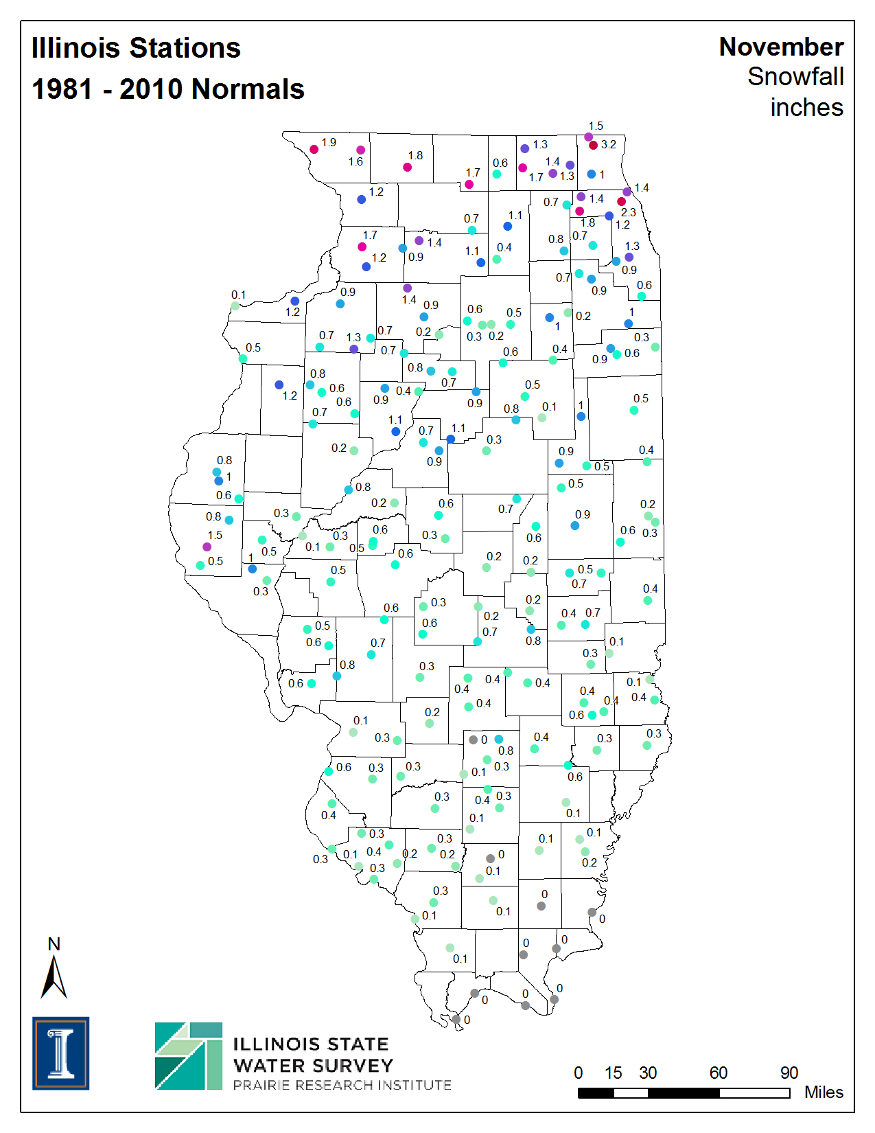 |
The map at left, courtesy of the Illinois State Water Survey, shows the normal snowfall across the state during November. The area that received the heaviest snow in this evening typically would only see around an inch for the entire month. The 13.2 inches at Altona was the greatest 1-day snowfall total on record for that location. However, the climate record there only dates back to 2004. Peoria received 4.1 inches of snow from this event. For the month of November, Peoria has had 9.3 inches of snow. While the snow from the event did not set a record, the monthly total ranks 2nd for November, surpassed only by 10.7 inches in 1926. |
Other Information
 |
 |
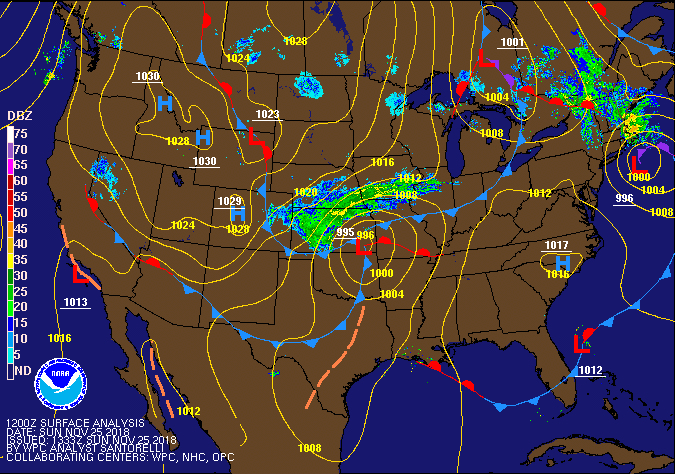 |
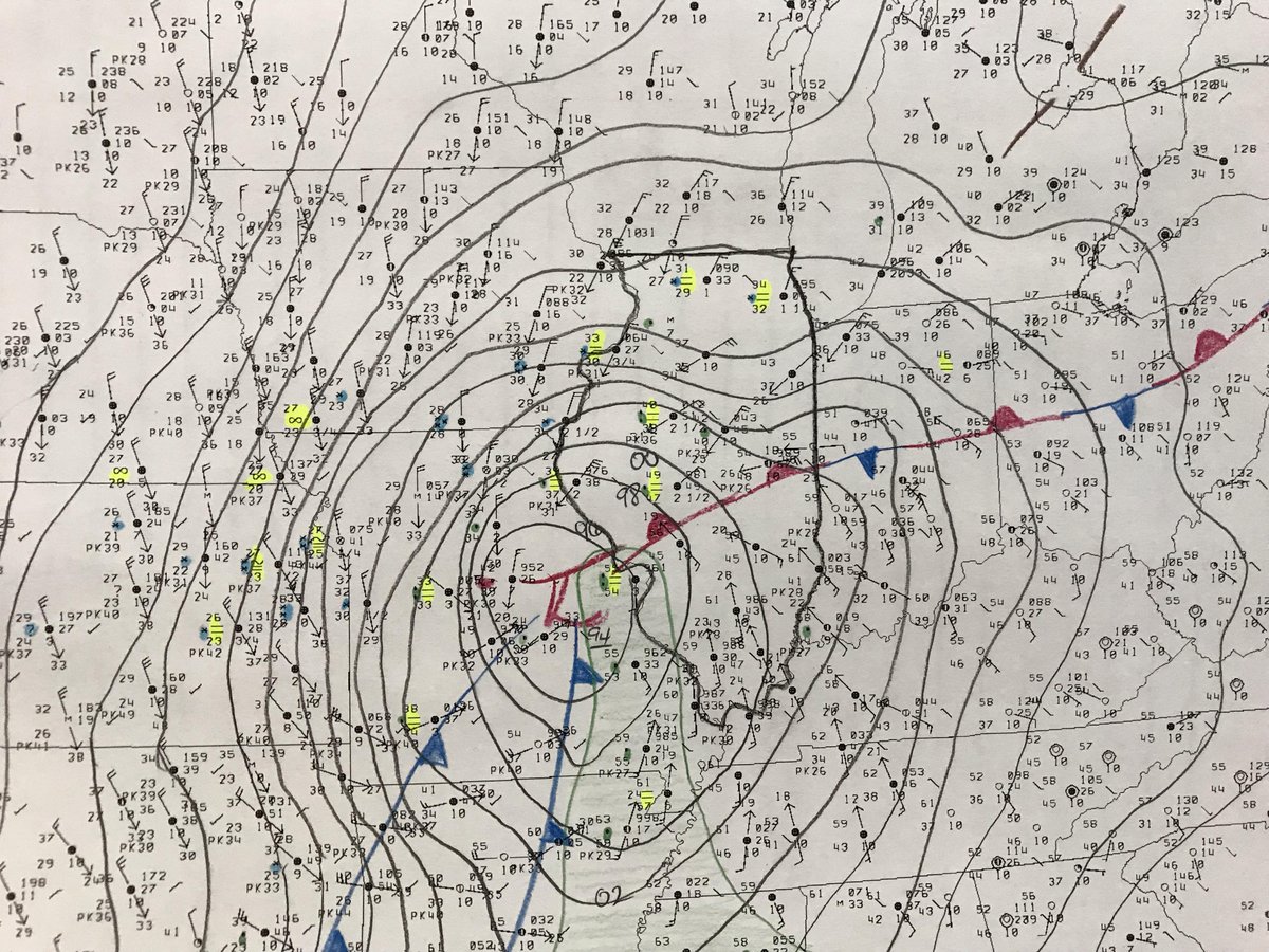
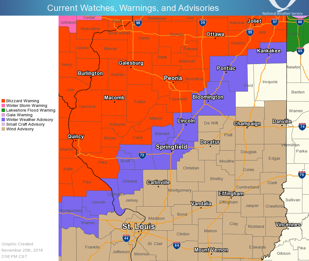
| Surface map at 3 pm Sunday, November 25 | Map of warnings and advisories, 4 pm Sunday | Loop of storm track |
Blizzard Warnings were issued for central Illinois late in the morning on the 25th. Our office has issued only 7 Blizzard Warnings in its history (since 1995), and the first one occurred in 2006. Of these 7, this particular event was the earliest in the winter season we have issued a Blizzard Warning. Prior to this, the earliest such warning was on December 11, 2010.
 |
Media use of NWS Web News Stories is encouraged! Please acknowledge the NWS as the source of any news information accessed from this site. |
|

