Overview
|
An extended period of severe weather impacted central and southeast Illinois on Monday, April 27th. The first wave moved through during the morning hours, and by early afternoon, the storms were just north of I-70. This period of severe weather produced scattered areas of wind damage, along with a number of large hail reports and even a funnel cloud along I-70 near Casey. There was also some flash flooding along the I-72 corridor. By mid to late afternoon, additional severe storms rapidly developed across Missouri and west central Illinois, forming into a line which quickly moved east past the I-55 corridor. The storms reached I-70 between 8-9 pm and had largely moved out of the area by 10 pm. Widespread wind damage of 70-80 mph was reported across central parts of the state with NWS damage surveys confirming 5 EF1 tornadoes between Mt. Pulaski (Logan County) and Mahomet (Champaign County). Heavy rain resulted in flash flooding from near Springfield and Decatur southeast to Effingham. |
 Radar loop spanning from 7:30 am to 11 pm CDT, at 30 minute intervals. (Iowa Environmental Mesonet) |
Tornadoes
Select a tornado from the table to zoom into the track and view more information. The default table view is limited to 8 tracks, but can be scrolled by a mouse wheel or dynamically expanded. Additionally, the table can fill the entire window by clicking the small circular expanding arrow icon at the very top right of the table and returned to its original size by clicking the button again. The side information panel that opens over the map can be closed using the "X" on the upper right corner of the pop-up. Zoom into the map and click damage points to see detailed information and pictures from the surveys.
|
NOTE: times shown below are local to your device's time zone. |

The Enhanced Fujita (EF) Scale classifies tornadoes into the following categories:
| EF0 Weak 65-85 mph |
EF1 Moderate 86-110 mph |
EF2 Significant 111-135 mph |
EF3 Severe 136-165 mph |
EF4 Extreme 166-200 mph |
EF5 Catastrophic 200+ mph |
 |
|||||
| Tornadoes that fail to impact any ratable damage indicators on the EF-Scale are rated EF-Unknown (EF-U) | |||||
Rain Reports

Location Amount Time/Date Provider
...Cass County...
3 SE Bluff Springs 2.03 in 0700 AM 04/28 COCORAHS
...Champaign County...
Philo 3.20 in 0700 AM 04/28 COCORAHS
Sidney 0.9 N 2.97 in 0700 AM 04/28 COCORAHS
Urbana 2.2 SE 2.72 in 0700 AM 04/28 COCORAHS
Urbana 1.0 WSW 2.67 in 0900 AM 04/28 COCORAHS
Urbana 1.8 S 2.67 in 0900 AM 04/28 COCORAHS
Champaign 2.6 WNW 2.64 in 0700 AM 04/28 COCORAHS
Urbana 0.5 W 2.60 in 0700 AM 04/28 COCORAHS
Urbana 1.6 ESE 2.58 in 0640 AM 04/28 COCORAHS
St. Joseph 1.1 ENE 2.57 in 0600 AM 04/28 COCORAHS
Champaign 0.6 NNE 2.56 in 0600 AM 04/28 COCORAHS
Champaign 0.3 NNE 2.54 in 0800 AM 04/28 COCORAHS
Urbana 2.47 in 0700 AM 04/28 COCORAHS
Urbana 2.47 in 0700 AM 04/28 COCORAHS
Urbana 2.4 SSE 2.46 in 0700 AM 04/28 COCORAHS
Champaign 2.3 SSE 2.43 in 0800 AM 04/28 COCORAHS
Willard Airport 2.43 in 0700 AM 04/28 ASOS
Homer 2.0 NW 2.40 in 0800 AM 04/28 COCORAHS
Urbana 2.6 ENE 2.40 in 0700 AM 04/28 COCORAHS
Urbana 1.9 ENE 2.40 in 0700 AM 04/28 COCORAHS
Homer 0.6 NNW 2.37 in 0600 AM 04/28 COCORAHS
Champaign 2.4 SSE 2.37 in 0800 AM 04/28 COCORAHS
Champaign 2.2 SSE 2.36 in 0700 AM 04/28 COCORAHS
Champaign 2.2 SW 2.34 in 0800 AM 04/28 COCORAHS
Champaign 1.3 SSW 2.33 in 0630 AM 04/28 COCORAHS
Savoy 0.6 SSE 2.32 in 0700 AM 04/28 COCORAHS
Urbana 0.3 SE 2.29 in 0700 AM 04/28 COCORAHS
4 WNW Saint Joseph 2.26 in 0800 AM 04/28 COCORAHS
Champaign 2.5 S 2.26 in 0625 AM 04/28 COCORAHS
Champaign 2.2 S 2.20 in 0900 AM 04/28 COCORAHS
Homer 2.0 N 2.18 in 0700 AM 04/28 COCORAHS
Homer 2.1 NNE 2.13 in 0700 AM 04/28 COCORAHS
Urbana 0.1 SSE 2.12 in 0700 AM 04/28 COCORAHS
Savoy 2.6 WSW 2.11 in 0800 AM 04/28 COCORAHS
Champaign 0.3 ESE 2.11 in 0830 AM 04/28 COCORAHS
Homer 2.0 WSW 1.99 in 0700 AM 04/28 COCORAHS
Mahomet 1.0 NW 1.83 in 0700 AM 04/28 COCORAHS
Mahomet 1.83 in 0730 AM 04/28 COCORAHS
Mahomet 1.7 NNE 1.79 in 0700 AM 04/28 COCORAHS
Mahomet 1.6 E 1.64 in 0645 AM 04/28 COCORAHS
Mahomet 3.0 NE 1.62 in 0700 AM 04/28 COCORAHS
Mahomet 5.5 NE 1.53 in 0700 AM 04/28 COCORAHS
Dewey 2.70 NW 1.34 in 0715 AM 04/28 COCORAHS
Foosland 5.0 ENE 1.30 in 0800 AM 04/28 COCORAHS
Fisher 1.26 in 0700 AM 04/28 COOP
Broadlands 0.1 SSW 1.19 in 0100 PM 04/27 COCORAHS
...Christian County...
2.5 W Taylorville 3.39 in 0700 AM 04/28 COOP
Taylorville 0.6 ENE 3.20 in 0700 AM 04/28 COCORAHS
Morrisonville 0.5 SSE 3.11 in 0730 AM 04/28 COCORAHS
Pana 6.2 NNE 2.44 in 0700 AM 04/28 COCORAHS
Edinburg 3.0 W 1.45 in 0700 AM 04/28 COCORAHS
...Clark County...
Casey 2.05 in 0730 AM 04/28 COOP
...Clay County...
Flora 2.83 in 0630 AM 04/28 COOP
Flora 2.21 in 0646 AM 04/28 UCOOP
Clay City 6 SSE 1.65 in 0600 AM 04/28 COOP
...Coles County...
Mattoon 2.1 W 3.26 in 0700 AM 04/28 COCORAHS
Charleston 4.7 SSW 3.02 in 0700 AM 04/28 COCORAHS
Charleston 0.8 NW 3.00 in 0830 AM 04/28 COCORAHS
Mattoon 2.97 in 0800 AM 04/28 COOP
Coles County Airport 2.95 in 0700 AM 04/28 ASOS
...Crawford County...
2.0 W Robinson 2.80 in 0700 AM 04/28 COOP
Hutsonville 2.32 in 0700 AM 04/28 COCORAHS
...Cumberland County...
Toledo 5.8 W 2.37 in 0700 AM 04/28 COCORAHS
...De Witt County...
Farmer City 2.7 WSW 1.95 in 0700 AM 04/28 COCORAHS
Farmer City 1.5 SSW 1.93 in 0700 AM 04/28 COCORAHS
3 SW Farmer City 1.80 in 0800 AM 04/28 COCORAHS
...Douglas County...
Tuscola 0.5 WSW 2.83 in 0700 AM 04/28 COCORAHS
Tuscola 2.83 in 0700 AM 04/28 COOP
Newman 2.73 in 0600 AM 04/28 COCORAHS
Tuscola 0.6 NNE 2.68 in 0830 AM 04/28 COCORAHS
Camargo 4.5 ESE 2.35 in 0815 AM 04/28 COCORAHS
...Edgar County...
Kansas 3.7 SSE 3.11 in 0500 AM 04/28 COCORAHS
Paris 6.7 S 2.70 in 0716 AM 04/28 COCORAHS
Paris 6.0 SSW 2.62 in 0700 AM 04/28 COCORAHS
Paris 2.20 in 0700 AM 04/28 COOP
...Effingham County...
Beecher City 4.98 in 0800 AM 04/28 COOP
Effingham 2.3 WNW 3.36 in 1000 AM 04/28 COCORAHS
Watson 3.35 in 0800 AM 04/28 COCORAHS
Effingham 4.2 WNW 3.34 in 0600 AM 04/28 COCORAHS
Effingham 1.0 NNE 3.33 in 0700 AM 04/28 COCORAHS
Effingham 1SE 3.20 in 0700 AM 04/28 COOP
Teutopolis 3.4 SE 3.15 in 0730 AM 04/28 COCORAHS
Dieterich 10.1 SW 3.09 in 0700 AM 04/28 COCORAHS
Altamont 3.8 SSW 2.82 in 0715 AM 04/28 COCORAHS
...Fulton County...
Bryant 0.1 ENE 2.09 in 0700 AM 04/28 COCORAHS
Lewistown 0.3 W 1.87 in 0700 AM 04/28 COCORAHS
Fairview 2.0 SE 1.42 in 0730 AM 04/28 COCORAHS
London Mills 1.4 SE 1.14 in 0700 AM 04/28 COCORAHS
...Jasper County...
1.1 W Newton 3.20 in 1200 AM 04/28 COOP
Yale 0.1 SSW 2.40 in 0700 AM 04/28 COCORAHS
...Knox County...
Yates City 1.34 in 0700 AM 04/28 COOP
St. Augustine 0.1 NNW 0.99 in 0700 AM 04/28 COCORAHS
...Lawrence County...
Lawrenceville-Vincennes AP 3.28 in 0700 AM 04/28 ASOS
1.7 W Lawrenceville 3.19 in 0900 AM 04/28 COOP
...Logan County...
2 W Lincoln 2.70 in 0700 AM 04/28 COCORAHS
Lincoln (Airport) 2.69 in. 0700 AM 04/28 OFFICIAL NWS OBS
Mount Pulaski 2.53 in 0600 AM 04/28 COOP
Lincoln 2.0 ENE 2.52 in 0700 AM 04/28 COCORAHS
Elkhart 0.7 ENE 2.50 in 0630 AM 04/28 COCORAHS
Lincoln 2.26 in 0600 AM 04/28 COCORAHS
Lincoln 2.20 in 0700 AM 04/28 COCORAHS
Lincoln 0.6 NNW 2.16 in 0700 AM 04/28 COCORAHS
Hartsburg 3.2 E 2.14 in 0700 AM 04/28 COCORAHS
6 NE Lincoln 2.06 in 0700 AM 04/28 COCORAHS
2 NW Chestnut 2.00 in 0600 AM 04/28 COCORAHS
New Holland 1.88 in 0700 AM 04/28 COCORAHS
...Macon County...
Latham 1.8 SE 2.56 in 0700 AM 04/28 COCORAHS
Decatur Airport 2.50 in 0700 AM 04/28 ASOS
Dalton City 2.5 NW 2.20 in 0700 AM 04/28 COCORAHS
Illiopolis 4.4 NNE 2.11 in 0700 AM 04/28 COCORAHS
Decatur 6.5 WSW 2.01 in 0800 AM 04/28 COCORAHS
Oreana 1.3 S 1.93 in 0800 AM 04/28 COCORAHS
Decatur 3.3 WSW 1.90 in 0800 PM 04/27 COCORAHS
Decatur 3.0 W 1.88 in 0639 AM 04/28 COCORAHS
Warrensburg 0.6 E 1.41 in 0700 AM 04/28 COCORAHS
Dalton City 2.5 NW 0.09 in 0700 AM 04/27 COCORAHS
...Marshall County...
Sparland 3.4 NNW 0.58 in 0700 AM 04/28 COCORAHS
3 S Henry 0.58 in 0700 AM 04/28 COCORAHS
Henry 1.4 SW 0.57 in 0645 AM 04/28 COCORAHS
...Mason County...
Havana 3.0 E 1.57 in 0800 AM 04/28 COCORAHS
...McLean County...
Bloomington 1.6 WSW 2.34 in 0700 AM 04/28 COCORAHS
Bloomington 4.1 SW 2.24 in 0700 AM 04/28 COCORAHS
Bloomington 2.7 NE 2.14 in 0645 AM 04/28 COCORAHS
1 S Bloomington 2.14 in 0700 AM 04/28 COCORAHS
Arrowsmith 1.7 NNE 2.12 in 0800 AM 04/28 COCORAHS
Heyworth 0.6 E 2.10 in 0800 AM 04/28 COCORAHS
Bloomington 3.8 SW 2.10 in 0700 AM 04/28 COCORAHS
Le Roy 4.1 SSW 2.10 in 0700 AM 04/28 COCORAHS
Bloomington 1.5 ESE 2.05 in 0700 AM 04/28 COCORAHS
Le Roy 1.8 WSW 2.04 in 0700 AM 04/28 COCORAHS
Bloomington 2.0 WSW 2.03 in 0700 AM 04/28 COCORAHS
3 W Ellsworth 1.98 in 0700 AM 04/28 COCORAHS
Bloomington 0.9 SSE 1.96 in 0700 AM 04/28 COCORAHS
Bloomington 1.86 in 0800 AM 04/28 COOP
Le Roy 4.2 WSW 1.86 in 0657 AM 04/28 COCORAHS
Bloomington 5.0 WSW 1.81 in 0700 AM 04/28 COCORAHS
Normal 1.2 ESE 1.79 in 0700 AM 04/28 COCORAHS
Bloomington 3.9 ESE 1.61 in 0600 AM 04/28 COCORAHS
4 NE Normal 1.48 in 0500 AM 04/28 COOP
Carlock 2.1 NNE 1.45 in 0600 AM 04/28 COCORAHS
Normal 3.6 NE 1.43 in 0900 AM 04/28 COCORAHS
Saybrook 4.3 SSE 1.41 in 0700 AM 04/28 COCORAHS
Central IL Regional Arpt 1.28 in 0700 AM 04/28 AWOS
Normal 1.4 WNW 1.27 in 0700 AM 04/28 COCORAHS
...Menard County...
Tallula 3.0 WSW 2.76 in 0900 AM 04/28 COCORAHS
Athens 4 WSW 2.70 in 0600 AM 04/28 COOP
Petersburg 6.5 SSE 2.70 in 0600 AM 04/28 COCORAHS
Petersburg 0.2 W 2.41 in 0630 AM 04/28 COCORAHS
Athens 2.34 in 0700 AM 04/28 COCORAHS
Petersburg 1.3 N 2.20 in 0700 AM 04/28 COCORAHS
...Morgan County...
1 NNE Jacksonville Airport 3.08 in 0700 AM 04/28 COCORAHS
2.0 E Jacksonville 3.06 in 0530 AM 04/28 COOP
Jacksonville 2.6 SE 2.70 in 0700 AM 04/28 COCORAHS
Jacksonville 1.23 in 0700 AM 04/28 COOP
...Moultrie County...
Arthur 0.8 NNW 2.82 in 0605 AM 04/28 COCORAHS
Lovington 4.1 NNW 2.28 in 0645 AM 04/28 COCORAHS
1 E Bethany 1.90 in 0600 AM 04/28 COCORAHS
Lovington 1.83 in 0700 AM 04/28 COOP
...Peoria County...
Peoria Int'l Airport 2.09 in 0700 AM 04/28 OFFICIAL NWS OBS
Peoria 3.4 WNW 1.55 in 0500 AM 04/28 COCORAHS
Peoria 5 NW 1.39 in 0800 AM 04/28 COOP
Dunlap 2.6 S 1.11 in 0700 AM 04/28 COCORAHS
Dunlap 2.6 NE 0.82 in 0700 AM 04/28 COCORAHS
...Piatt County...
4 NE Hammond 3.33 in 0800 AM 04/28 COCORAHS
Bement 1.5 SE 2.35 in 0700 AM 04/28 COCORAHS
Cisco 2.01 in 0600 AM 04/28 COOP
Monticello 6.5 WSW 2.00 in 0700 AM 04/28 COCORAHS
Monticello 0.4 ENE 1.97 in 0800 AM 04/28 COCORAHS
4 NNE Monticello 1.95 in 0628 AM 04/28 COCORAHS
3 SE Mansfield 1.87 in 0600 AM 04/28 COCORAHS
White Heath 3.7 NNE 1.80 in 0800 AM 04/28 COCORAHS
4 N Cerro Gordo 1.75 in 0700 AM 04/28 COCORAHS
3 S Mansfield 1.75 in 0700 AM 04/28 COCORAHS
...Richland County...
Olney 1.5 NE 3.28 in 0800 AM 04/28 COCORAHS
Olney 2 S 2.86 in 0600 AM 04/28 COOP
Dundas 1.4 E 2.74 in 1000 AM 04/28 COCORAHS
Olney 0.3 ESE 2.51 in 0600 AM 04/28 COCORAHS
...Sangamon County...
Sherman 3.73 in 0700 AM 04/28 COOP
Williamsville 0.4 ESE 3.65 in 0700 AM 04/28 COCORAHS
Capital Airport 3.57 in 0700 AM 04/28 OFFICIAL NWS OBS
2 W Riverton 3.31 in 0700 AM 04/28 COCORAHS
Buffalo 3.24 in 0700 AM 04/28 COOP
Springfield 4.4 W 3.21 in 0700 AM 04/28 COCORAHS
1 ESE Chatham 2.78 in 0800 AM 04/28 COCORAHS
Springfield 2.2 SE 2.73 in 0700 AM 04/28 COCORAHS
4 NNE Curran 2.56 in 0700 AM 04/28 COCORAHS
Lake Springfield 2.10 in 0800 AM 04/28 COOP
Springfield 6.3 S 1.46 in 0800 AM 04/28 COCORAHS
...Schuyler County...
Rushville 4.1 NE 1.34 in 0700 AM 04/28 COCORAHS
...Shelby County...
Shelbyville 0.5 NE 2.43 in 0700 AM 04/28 COCORAHS
Moweaqua 2 S 2.21 in 0600 AM 04/28 COOP
Windsor 2.05 in 0630 AM 04/28 COOP
...Tazewell County...
Morton 2.27 in 0700 AM 04/28 COCORAHS
Morton 2.13 in 0700 AM 04/28 COOP
Morton 5.1 E 2.06 in 0700 AM 04/28 COCORAHS
Morton 1.5 ENE 2.00 in 0700 AM 04/28 COCORAHS
Washington 1.7 NE 1.76 in 0700 AM 04/28 COCORAHS
Tremont 3.6 E 1.75 in 0800 PM 04/27 COCORAHS
Washington 2.2 NNW 1.71 in 0700 AM 04/28 COCORAHS
Washington 2.0 NNW 1.69 in 0715 AM 04/28 COCORAHS
Washington 2.1 NW 1.62 in 0700 AM 04/28 COCORAHS
Eureka 3.5 W 1.58 in 0634 AM 04/28 COCORAHS
Pekin 4.3 NE 1.47 in 0800 AM 04/28 COCORAHS
3 NW Hopedale 1.02 in 0700 AM 04/28 COCORAHS
...Vermilion County...
Fithian 0.6 NNW 2.48 in 0700 AM 04/28 COCORAHS
Collison 1.9 SE 2.46 in 0700 AM 04/28 COCORAHS
Henning 3.4 SE 2.20 in 0700 AM 04/28 COCORAHS
Fithian 2.6 ESE 2.14 in 0700 AM 04/28 COCORAHS
Georgetown 0.1 NNW 1.98 in 0700 AM 04/28 COCORAHS
Danville 4.2 NW 1.95 in 0600 AM 04/28 COCORAHS
Danville 3.1 NNW 1.90 in 0700 AM 04/28 COCORAHS
Danville 0.7 NNW 1.86 in 0700 AM 04/28 COCORAHS
Sidell 4N 1.79 in 0700 AM 04/28 COOP
Danville 1.1 WNW 1.72 in 0715 AM 04/28 COCORAHS
Danville 2.5 E 1.55 in 0830 AM 04/28 COCORAHS
Oakwood 0.5 SSE 1.11 in 0600 AM 04/28 COCORAHS
...Woodford County...
Congerville 0.6 WSW 2.12 in 0700 AM 04/28 COCORAHS
Germantown Hills 0.5 SSW 1.89 in 0700 AM 04/28 COCORAHS
Metamora 6.4 W 1.45 in 0800 AM 04/28 COCORAHS
Cazenovia 1.0 ESE 1.41 in 0700 AM 04/28 COCORAHS
East Peoria 6.9 NNE 1.40 in 0633 AM 04/28 COCORAHS
Roanoke 1.36 in 0700 AM 04/28 COOP
Minonk 1.15 in 0800 AM 04/28 COOP
El Paso 5.2 NNW 1.05 in 0700 AM 04/28 COCORAHS
Observations are collected from a variety of sources with varying
equipment and exposures. We thank all volunteer weather observers
for their dedication. Not all data listed are considered official.
Storm Reports


Local storm reports received. Left image: Reports between 6 am and 3 pm. Right image: Reports between 3 pm and 11 pm.
..TIME... ...EVENT... ...CITY LOCATION... ...LAT.LON...
..DATE... ....MAG.... ..COUNTY LOCATION..ST.. ...SOURCE....
..REMARKS..
0850 AM Hail Jerome 39.77N 89.68W
04/27/2026 M1.25 Inch Sangamon IL Public
delayed report from morning storms. Picture
of quarter to half dollar size hail.
0855 AM Hail 1 NE Southern View 39.76N 89.65W
04/27/2026 E1.00 Inch Sangamon IL Public
0856 AM Hail 2 SE Southern View 39.74N 89.63W
04/27/2026 M0.75 Inch Sangamon IL Public
0856 AM Hail 2 SE Springfield 39.79N 89.63W
04/27/2026 M1.00 Inch Sangamon IL Broadcast Media
0856 AM Hail 2 SE Southern View 39.73N 89.64W
04/27/2026 E1.00 Inch Sangamon IL Public
Report from mPING: Quarter (1.00 in.).
0857 AM Hail Springfield 39.80N 89.65W
04/27/2026 M1.50 Inch Sangamon IL Broadcast Media
0857 AM Hail Springfield 39.80N 89.65W
04/27/2026 E0.75 Inch Sangamon IL Public
Report from mPING: Dime (0.75 in.).
0858 AM Hail 1 SE Springfield 39.79N 89.64W
04/27/2026 E1.25 Inch Sangamon IL Public
Report from mPING: Half Dollar (1.25 in.).
0859 AM Hail 1 SW Grandview 39.81N 89.63W
04/27/2026 M1.50 Inch Sangamon IL Broadcast Media
0859 AM Hail 1 W Jerome 39.76N 89.69W
04/27/2026 E1.00 Inch Sangamon IL Public
Report from mPING: Quarter (1.00 in.).
0900 AM Hail Springfield 39.80N 89.65W
04/27/2026 E0.75 Inch Sangamon IL Public
Report from mPING: Dime (0.75 in.).
0901 AM Hail Springfield 39.80N 89.65W
04/27/2026 E1.00 Inch Sangamon IL Public
Report from mPING: Quarter (1.00 in.).
0925 AM Tstm Wnd Dmg 1 SW Chapin 39.76N 90.42W
04/27/2026 Morgan IL Emergency Mngr
EMA reports tree and powerlines downed by
thunderstorm winds.
0936 AM Tstm Wnd Gst 1 N Marietta 40.51N 90.39W
04/27/2026 E60 MPH Fulton IL Emergency Mngr
1003 AM Tstm Wnd Gst Canton 40.56N 90.04W
04/27/2026 M55 MPH Fulton IL Mesonet
Estimated 50-55 mph winds from SWOP
observer.
1048 AM Tstm Wnd Dmg 2 SW Taylorville Airpor 39.50N 89.36W
04/27/2026 Christian IL Emergency Mngr
Tree downed across roadway, causing a semi
rollover.
1117 AM Tstm Wnd Gst 1 WSW Decatur Airport 39.83N 88.87W
04/27/2026 M56 MPH Macon IL ASOS
Corrects previous non-tstm wnd gst report
from 1 WSW Decatur Airport. ASOS station
KDEC Decatur Arpt.
1120 AM Rain 3 NE Curran 39.78N 89.75W
04/27/2026 M2.12 Inch Sangamon IL Public
1127 AM Hail 2 S Olney 38.71N 88.09W
04/27/2026 E0.75 Inch Richland IL Public
Report from mPING: Dime (0.75 in.).
1130 AM Hail Olney 38.72N 88.09W
04/27/2026 M1.00 Inch Richland IL Trained Spotter
1131 AM Hail 1 E Olney 38.73N 88.07W
04/27/2026 E1.00 Inch Richland IL Public
Report from mPING: Quarter (1.00 in.).
1155 AM Hail Eureka 40.72N 89.27W
04/27/2026 E1.25 Inch Woodford IL Public
Report from mPING: Half Dollar (1.25 in.).
1241 PM Tstm Wnd Dmg Altamont 39.06N 88.75W
04/27/2026 Effingham IL Emergency Mngr
Tree blown down into a mobile home. No
injuries reported.
1255 PM Funnel Cloud 1 NE Casey 39.31N 87.99W
04/27/2026 Clark IL Public
0116 PM Tstm Wnd Gst Oblong 39.00N 87.91W
04/27/2026 M71 MPH Crawford IL Public
Wind gust from an automated weather station.
0220 PM Non-Tstm Wnd Dmg Urbana 40.11N 88.20W
04/27/2026 Champaign IL Emergency Mngr
two large branches down, 6-8 inches and 12
inches in diameter.
0220 PM Non-Tstm Wnd Dmg 1 S Savoy 40.05N 88.25W
04/27/2026 Champaign IL Emergency Mngr
Large tree branch down on road and it took
down a power line.
0234 PM Non-Tstm Wnd Gst Willard Airport 40.03N 88.28W
04/27/2026 M52 MPH Champaign IL ASOS
ASOS station KCMI Willard Arpt.
0245 PM Hail 2 SE Clay City 38.68N 88.33W
04/27/2026 E0.75 Inch Clay IL Public
Report from mPING: Dime (0.75 in.).
0250 PM Lightning 2 NW Neoga 39.34N 88.47W
04/27/2026 Shelby IL Public
Lightning struck a tree and split it at Lake
Mattoon. Time estimated.
0319 PM Hail 3 ESE Claremont 38.70N 87.93W
04/27/2026 M1.00 Inch Richland IL Public
0326 PM Hail 2 SW Bridgeport 38.69N 87.78W
04/27/2026 E0.75 Inch Lawrence IL Public
Report from mPING: Dime (0.75 in.).
0330 PM Hail Bridgeport 38.71N 87.76W
04/27/2026 E1.00 Inch Lawrence IL Public
0332 PM Hail Bridgeport 38.71N 87.76W
04/27/2026 M1.00 Inch Lawrence IL Trained Spotter
0333 PM Non-Tstm Wnd Gst Coles County Airport 39.47N 88.27W
04/27/2026 M52 MPH Coles IL ASOS
ASOS station KMTO Coles Co. Mem AP.
0338 PM Hail Bridgeport 38.71N 87.76W
04/27/2026 E1.25 Inch Lawrence IL Public
Report from mPING: Half Dollar (1.25 in.).
0352 PM Non-Tstm Wnd Gst Coles County Airport 39.47N 88.27W
04/27/2026 M53 MPH Coles IL ASOS
ASOS station KMTO Coles Co. Mem AP.
0408 PM Hail 1 NE Bridgeport 38.72N 87.74W
04/27/2026 E0.75 Inch Lawrence IL Public
Report from mPING: Dime (0.75 in.).
0454 PM Non-Tstm Wnd Gst 1 WSW Decatur Airport 39.83N 88.87W
04/27/2026 M52 MPH Macon IL ASOS
ASOS station KDEC Decatur Arpt.
0500 PM Hail 1 N Pleasant Plains 39.89N 89.92W
04/27/2026 E0.88 Inch Sangamon IL Fire Dept/Rescue
0512 PM Hail 1 W Congerville 40.62N 89.22W
04/27/2026 E1.50 Inch Woodford IL Public
Report from mPING: Ping Pong Ball (1.50
in.).
0540 PM Tstm Wnd Dmg 2 NE Alexander 39.74N 90.01W
04/27/2026 Morgan IL Emergency Mngr
Power lines down.
0548 PM Hail Pleasant Plains 39.87N 89.92W
04/27/2026 M1.00 Inch Sangamon IL Emergency Mngr
0552 PM Hail Tallula 39.95N 89.94W
04/27/2026 M1.00 Inch Menard IL Law Enforcement
North end of Tallula.
0605 PM Tstm Wnd Dmg 2 NNW Waverly 39.62N 89.96W
04/27/2026 Morgan IL Public
Large tree snapped, and wooden fence posts
snapped at the base. Time estimated from
radar.
0610 PM Tstm Wnd Gst Willard Airport 40.04N 88.27W
04/27/2026 M62 MPH Champaign IL ASOS
0610 PM Tstm Wnd Gst Ogden 40.11N 87.96W
04/27/2026 M64 MPH Champaign IL CO-OP Observer
0614 PM Tstm Wnd Dmg 1 WSW Lincoln 40.14N 89.37W
04/27/2026 Logan IL Emergency Mngr
Tree and power lines down.
0615 PM Tstm Wnd Gst NWS Lincoln 40.15N 89.34W
04/27/2026 E60 MPH Logan IL NWS Employee
0616 PM Tstm Wnd Dmg 3 SSE NWS Lincoln 40.11N 89.32W
04/27/2026 Logan IL NWS Storm Survey
Large half of tree snapped along highway 121
north of Chestervale.
0616 PM Tstm Wnd Dmg 1 WNW Mount Pulaski 40.02N 89.31W
04/27/2026 Logan IL Emergency Mngr
Large tree down & out building tin scattered
around property.
0617 PM Tstm Wnd Dmg 1 N Mount Pulaski 40.02N 89.28W
04/27/2026 Logan IL Emergency Mngr
Large tree uprooted.
0617 PM Tstm Wnd Dmg 1 NNW Mount Pulaski 40.02N 89.29W
04/27/2026 Logan IL Emergency Mngr
Picture of tree snapped.
0629 PM Flash Flood 2 E Elwin 39.78N 88.94W
04/27/2026 Macon IL Public
Heavy field and creek flooding on Elwin Rd.
0629 PM Tstm Wnd Dmg 1 W Danville 40.14N 87.66W
04/27/2026 Vermilion IL Law Enforcement
Large tree down blocking both lanes.
0631 PM Flash Flood Congerville 40.62N 89.20W
04/27/2026 Woodford IL Emergency Mngr
Minor flooding around Congerville, Rte 150,
and Knapp Rd.
0636 PM Tstm Wnd Dmg 2 S Decatur 39.82N 88.95W
04/27/2026 Macon IL Emergency Mngr
12 inch live tree with top blown off.
0636 PM Flash Flood Macon 39.71N 89.00W
04/27/2026 Macon IL Emergency Mngr
Street flooding in town.
0638 PM Tstm Wnd Gst Warrensburg 39.93N 89.06W
04/27/2026 E70 MPH Macon IL Fire Dept/Rescue
0639 PM Tstm Wnd Gst Latham 39.97N 89.16W
04/27/2026 E80 MPH Logan IL Fire Dept/Rescue
Estimated 70-80 mph winds.
0641 PM Flash Flood 5 NE Atterberry 40.11N 89.85W
04/27/2026 Menard IL Emergency Mngr
Pictures of rapidly flowing field flooding.
0642 PM Tstm Wnd Dmg Lane 40.12N 88.86W
04/27/2026 De Witt IL Broadcast Media
Tree on a house.
0643 PM Tstm Wnd Gst 3 W Warrensburg 39.94N 89.11W
04/27/2026 E80 MPH Macon IL Law Enforcement
0643 PM Tstm Wnd Dmg Lane 40.12N 88.86W
04/27/2026 De Witt IL NWS Storm Survey
Large branches down.
0644 PM Tstm Wnd Dmg 2 WNW De Land 40.13N 88.69W
04/27/2026 Piatt IL Fire Dept/Rescue
Corrects previous flash flood report from 2
WNW De Land. Deland-Weldon school sustained
roof damage.
0645 PM Tstm Wnd Dmg Alvin 40.31N 87.61W
04/27/2026 Vermilion IL Emergency Mngr
Tree down across south bound lane of State Rt
119.
0645 PM Tstm Wnd Dmg 2 NW De Witt 40.20N 88.82W
04/27/2026 De Witt IL NWS Storm Survey
Power pole broken.
0648 PM Tstm Wnd Dmg Weldon 40.12N 88.75W
04/27/2026 De Witt IL Broadcast Media
Older tree down.
0648 PM Tstm Wnd Dmg Weldon 40.12N 88.75W
04/27/2026 De Witt IL Emergency Mngr
Power poles down and possibly a home with
roof off.
0650 PM Flash Flood 1 NW Pleasant Plains 39.89N 89.94W
04/27/2026 Sangamon IL Fire Dept/Rescue
East of IL Rte 123 on Sparrow Rd.
0650 PM Tstm Wnd Dmg 3 NE De Witt 40.22N 88.74W
04/27/2026 De Witt IL NWS Storm Survey
Tree trunk snapped near the base.
0650 PM Tstm Wnd Dmg 4 NNE De Witt 40.23N 88.75W
04/27/2026 De Witt IL NWS Storm Survey
3 power poles broken along Leroy Rd. south
of Buckeye Rd.
0651 PM Tstm Wnd Dmg 4 WSW Farmer City 40.22N 88.72W
04/27/2026 De Witt IL NWS Storm Survey
Large branches down in Parnell, with a
broken power line southwest of town along
the train tracks.
0652 PM Tstm Wnd Dmg 4 WSW Farmer City 40.22N 88.70W
04/27/2026 De Witt IL NWS Storm Survey
Tree trunks snapped.
0654 PM Tstm Wnd Dmg Mount Zion 39.78N 88.86W
04/27/2026 Macon IL Public
Tree fell on a building in Spitler Woods
State Park.
0655 PM Hail Saint Francisville 38.59N 87.65W
04/27/2026 M0.75 Inch Lawrence IL Trained Spotter
0659 PM Tstm Wnd Dmg 3 N Lodge 40.15N 88.56W
04/27/2026 Piatt IL Broadcast Media
Pictures of damage to several machine sheds
and buildings near a grain elevator.
Possible tornado.
0703 PM Tstm Wnd Gst Seymour 40.11N 88.43W
04/27/2026 M65 MPH Champaign IL Emergency Mngr
0705 PM Tstm Wnd Dmg 2 NW Lake of the Woods 40.23N 88.39W
04/27/2026 Champaign IL NWS Storm Survey
Tree uprooted along highway 47.
0705 PM Tstm Wnd Dmg 2 W Mahomet 40.19N 88.44W
04/27/2026 Champaign IL Emergency Mngr
Tree on a house.
0706 PM Tstm Wnd Dmg 1 W Mahomet 40.20N 88.43W
04/27/2026 Champaign IL Emergency Mngr
Power lines down with road closure.
0706 PM Tstm Wnd Dmg Mahomet 40.19N 88.40W
04/27/2026 Champaign IL Trained Spotter
Numerous 4-8 inch diameter tree branches
down. Fences blown down too.
0707 PM Tstm Wnd Gst Mahomet 40.19N 88.40W
04/27/2026 M65 MPH Champaign IL Emergency Mngr
0707 PM Flash Flood 3 E Buffalo 39.85N 89.35W
04/27/2026 Sangamon IL Public
Old Rte 36 and other roads near by flooded.
0710 PM Tstm Wnd Dmg 4 ENE Lake of the Woods 40.24N 88.31W
04/27/2026 Champaign IL NWS Storm Survey
Large tree limb snapped.
0713 PM Tstm Wnd Dmg Thomasboro 40.24N 88.19W
04/27/2026 Champaign IL NWS Storm Survey
Fence blown down.
0715 PM Tstm Wnd Dmg Lake of the Woods 40.20N 88.37W
04/27/2026 Champaign IL Public
Numerous large branches down 4-6 inches in
diameter. Wooden fences blown over.
0716 PM Tstm Wnd Dmg 1 SW Champaign 40.10N 88.28W
04/27/2026 Champaign IL Broadcast Media
Trees and power lines down near Centennial
Park.
0716 PM Tstm Wnd Dmg Thomasboro 40.24N 88.19W
04/27/2026 Champaign IL Broadcast Media
Tree limbs down.
0727 PM Tstm Wnd Dmg Latham 39.97N 89.16W
04/27/2026 Logan IL Emergency Mngr
Picture of large tree with snapped branches.
0728 PM Tstm Wnd Dmg 1 E Sidney 40.03N 88.05W
04/27/2026 Champaign IL Emergency Mngr
Trees down on Sidney/St Joseph Rd, near Home
Lake Rd.
0730 PM Tstm Wnd Dmg Saint Joseph 40.11N 88.04W
04/27/2026 Champaign IL Broadcast Media
Picture of tree down in town.
0732 PM Tstm Wnd Gst Ogden 40.11N 87.96W
04/27/2026 E60 MPH Champaign IL Emergency Mngr
Estimated over 60 mph winds.
0735 PM Tstm Wnd Dmg Ogden 40.11N 87.96W
04/27/2026 Champaign IL Broadcast Media
Picture of tree down on a house.
0736 PM Non-Tstm Wnd Gst Ogden 40.11N 87.96W
04/27/2026 E60 MPH Champaign IL Emergency Mngr
Winds estimated over 60 mph.
0736 PM Hail 1 NE Sidney 40.04N 88.06W
04/27/2026 E0.75 Inch Champaign IL Public
Report from mPING: Dime (0.75 in.).
0740 PM Tstm Wnd Dmg Allerton 39.91N 87.94W
04/27/2026 Vermilion IL Emergency Mngr
Tree down on house.
0748 PM Tstm Wnd Gst 2 E Danville 40.13N 87.59W
04/27/2026 M50 MPH Vermilion IL Public
0755 PM Tstm Wnd Dmg 3 SSE Beecher City 39.15N 88.76W
04/27/2026 Effingham IL Broadcast Media
Picture of metal in a field.
0813 PM Funnel Cloud 1 NW Effingham 39.13N 88.55W
04/27/2026 Effingham IL Public
0824 PM Flash Flood 4 WNW Cowden 39.26N 88.93W
04/27/2026 Shelby IL Emergency Mngr
Culvert washed out at this location.
0851 PM Flash Flood 3 W Trowbridge 39.32N 88.57W
04/27/2026 Shelby IL Emergency Mngr
3-4 foot of water moving over County Highway
33 just east of 3000 E Rd. Barricades are up
and road is closed.
0900 PM Tstm Wnd Dmg Xenia 38.64N 88.64W
04/27/2026 Clay IL Emergency Mngr
Corrects previous tstm wnd dmg report from
Xenia. Limb over the road.
0900 PM Tstm Wnd Dmg Louisville 38.77N 88.50W
04/27/2026 Clay IL Emergency Mngr
Tree on apartments. Injuries unknown.
0939 PM Tstm Wnd Dmg Sumner 38.71N 87.86W
04/27/2026 Lawrence IL Trained Spotter
0952 PM Tstm Wnd Gst Bridgeport 38.71N 87.76W
04/27/2026 E50 MPH Lawrence IL Trained Spotter
Small twigs blown down too.
Photos & Video
Header
 |
 |
 |
 |
| Mt. Pulaski tornado damage (NWS Storm Survey) |
Galesville tornado damage (NWS Storm Survey) |
Rowell tornado damage (NWS Storm Survey) |
Mahomet tornado damage (NWS Storm Survey) |
Radar
Header
| Caption | Caption | Caption | Caption |
Header
| Caption | Caption | Caption | Caption |
Header
| Caption | Caption | Caption | Caption |
Environment
Scattered thunderstorms well north of a warm front...and a line of convection that had developed on the nose of the nocturnal low-level jet over the Plains swept eastward across central Illinois during the morning of April 27th.
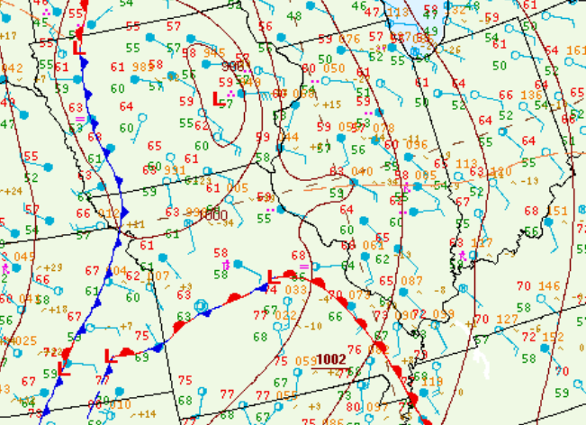 |
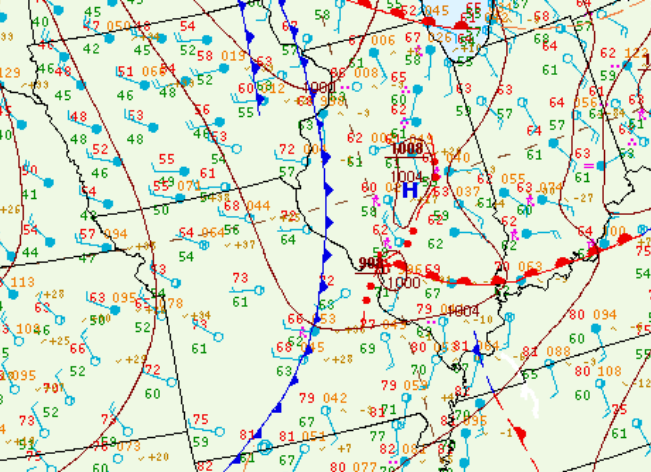 |
| 10am surface analysis | 7pm surface analysis |
The morning airmass was weakly unstable and sheared and led to only scattered reports of large hail and damaging wind gusts. As the environment destabilized and became significantly more sheared, an advancing line of storms produced widespread damaging wind gusts and a few tornadoes along and south of a Mason City to Hoopeston line from late afternoon through mid-evening.
 |
 |
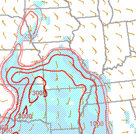
| 7am MLCAPE | 5pm MLCAPE |
Additional environmental data.
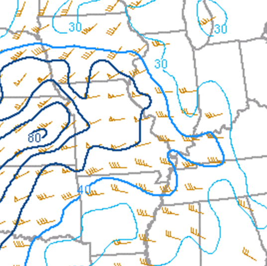 |
 |
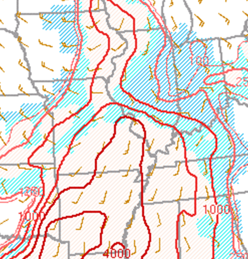
| 7am 0-6km shear | 5pm 0-6km shear |
 |
Media use of NWS Web News Stories is encouraged! Please acknowledge the NWS as the source of any news information accessed from this site. |
|

