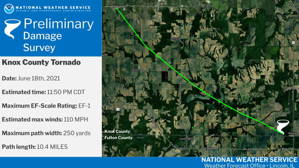
Public Information Statement
National Weather Service Lincoln IL
516 PM CDT Sat Jun 19 2021

...NWS DAMAGE SURVEY FOR 6/18/2021 TORNADO EVENT...

.Overview...
Severe thunderstorms produced a large swath of wind damage across
southern Knox and northern Fulton Counties late in the evening
on Friday June 18, and very early in the morning on Saturday
June 19. Within this area, a more concentrated damage path
was found over far southern Knox County.

.SOUTHERN KNOX COUNTY TORNADO...

Rating:                 EF1
Estimated Peak Wind:    110 mph
Path Length /statute/:  10.4 miles
Path Width /maximum/:   250 yards
Fatalities:             0
Injuries:               0

Start Date:             06/18/2021
Start Time:             11:50 PM CDT
Start Location:         3 SW DeLong / Knox County / IL
Start Lat/Lon:          40.7871 / -90.3382

End Date:               06/19/2021
End Time:               12:05 AM CDT
End Location:           3 WNW Middle Grove / Knox County / IL
End Lat/Lon:            40.7145 / -90.1673

Survey Summary:
The tornado was found to have touched down approximately 4 miles
east of Abingdon, or 3 miles southwest of DeLong. Trees were
broken and corn was snapped. The tornado moved southeast and
mainly damaged trees and corn, with significant damage to farm
outbuildings along county road 850E north of county highway 39,
and debris strewn southeast for over half a mile. The tornado
lifted about a mile west of Rapatee just north of the Fulton
County line.

Elsewhere, damage around Abingdon and in a large swath south
of the tornado track, through London Mills, Fairview and Canton,
was determined to be due to straight line winds. Much of this damage
was to crops, trees, and power poles. Wind speeds of 70 to 90 mph
were estimated to cause the damage along state highway 116 east
of London Mills.

&&

EF Scale: The Enhanced Fujita Scale classifies tornadoes into the
following categories:

EF0...Weak......65 to 85 mph
EF1...Weak......86 to 110 mph
EF2...Strong....111 to 135 mph
EF3...Strong....136 to 165 mph
EF4...Violent...166 to 200 mph
EF5...Violent...>200 mph

NOTE:
The information in this statement is preliminary and subject to
change pending final review of the event and publication in NWS
Storm Data.

$$

