Overview
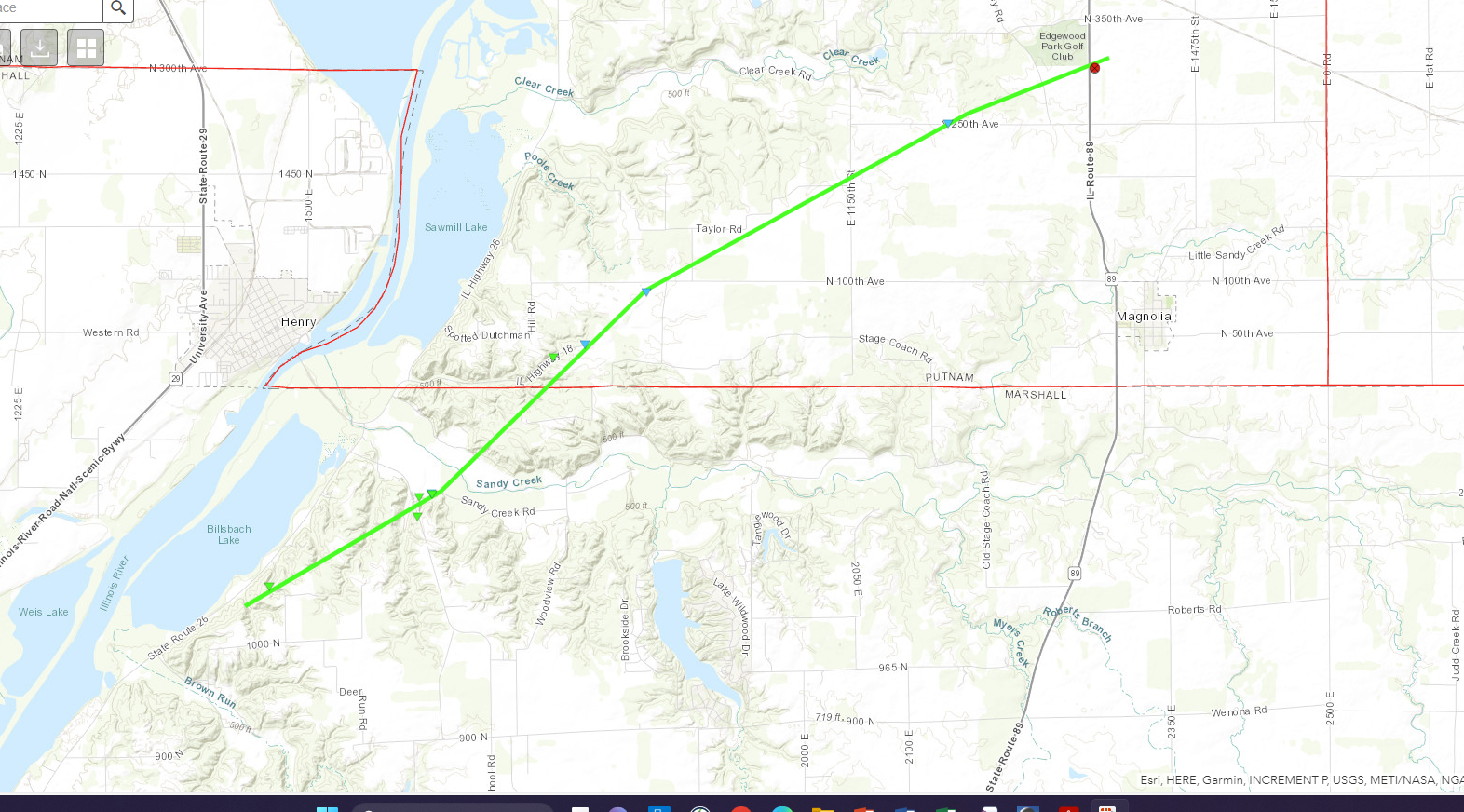
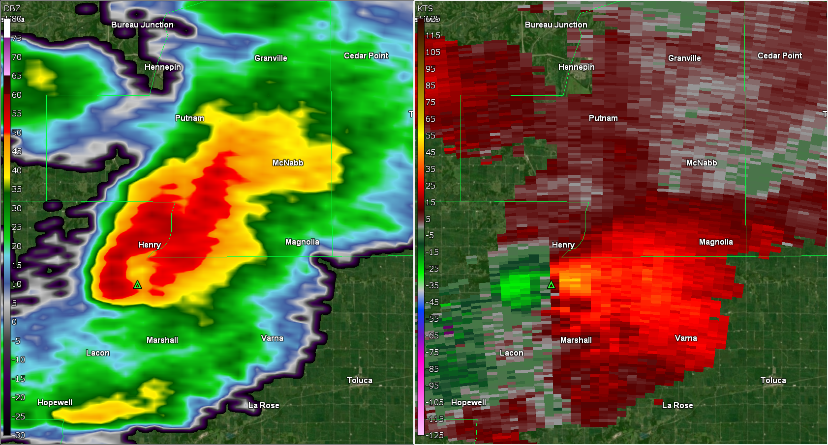
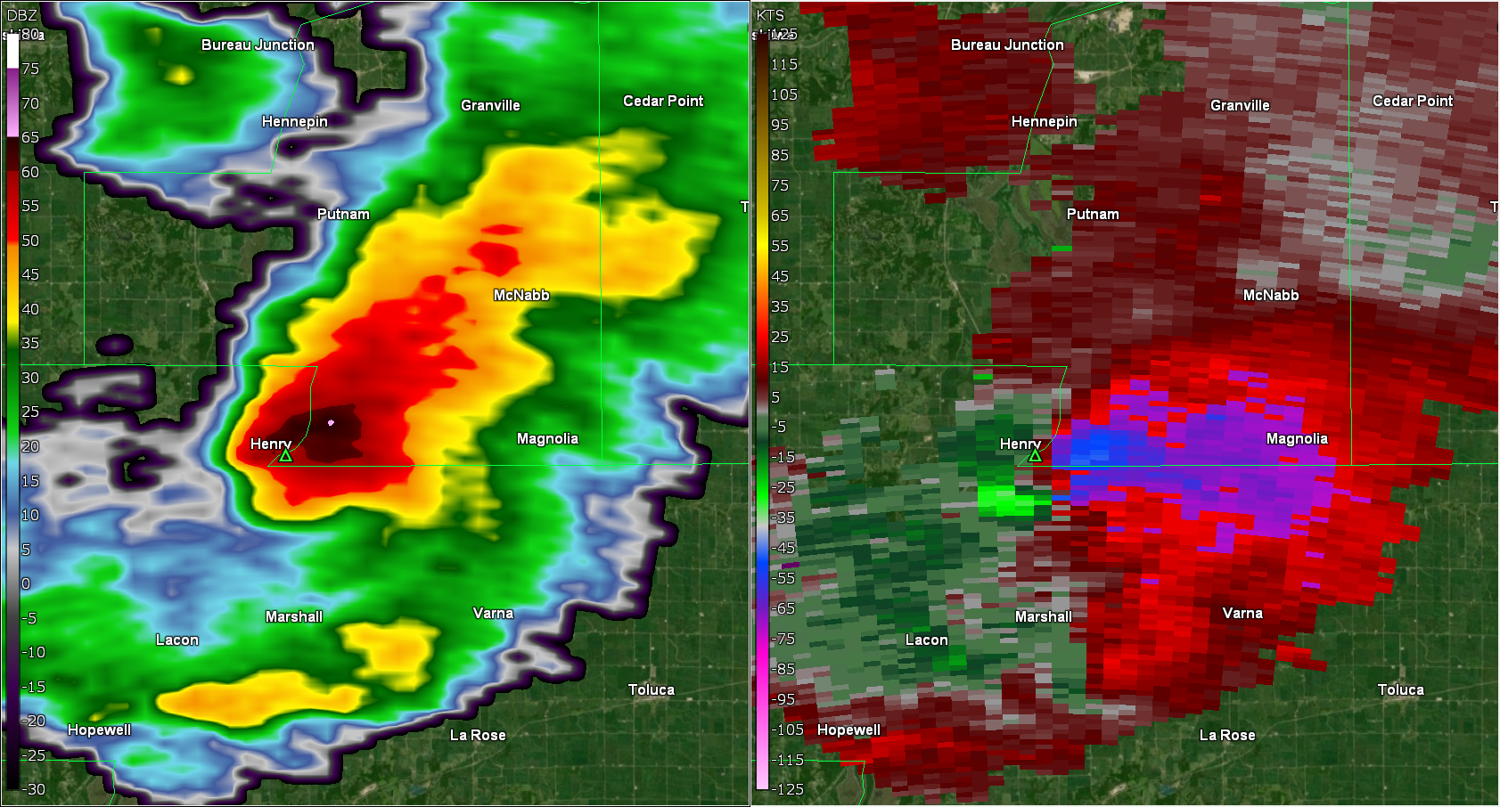
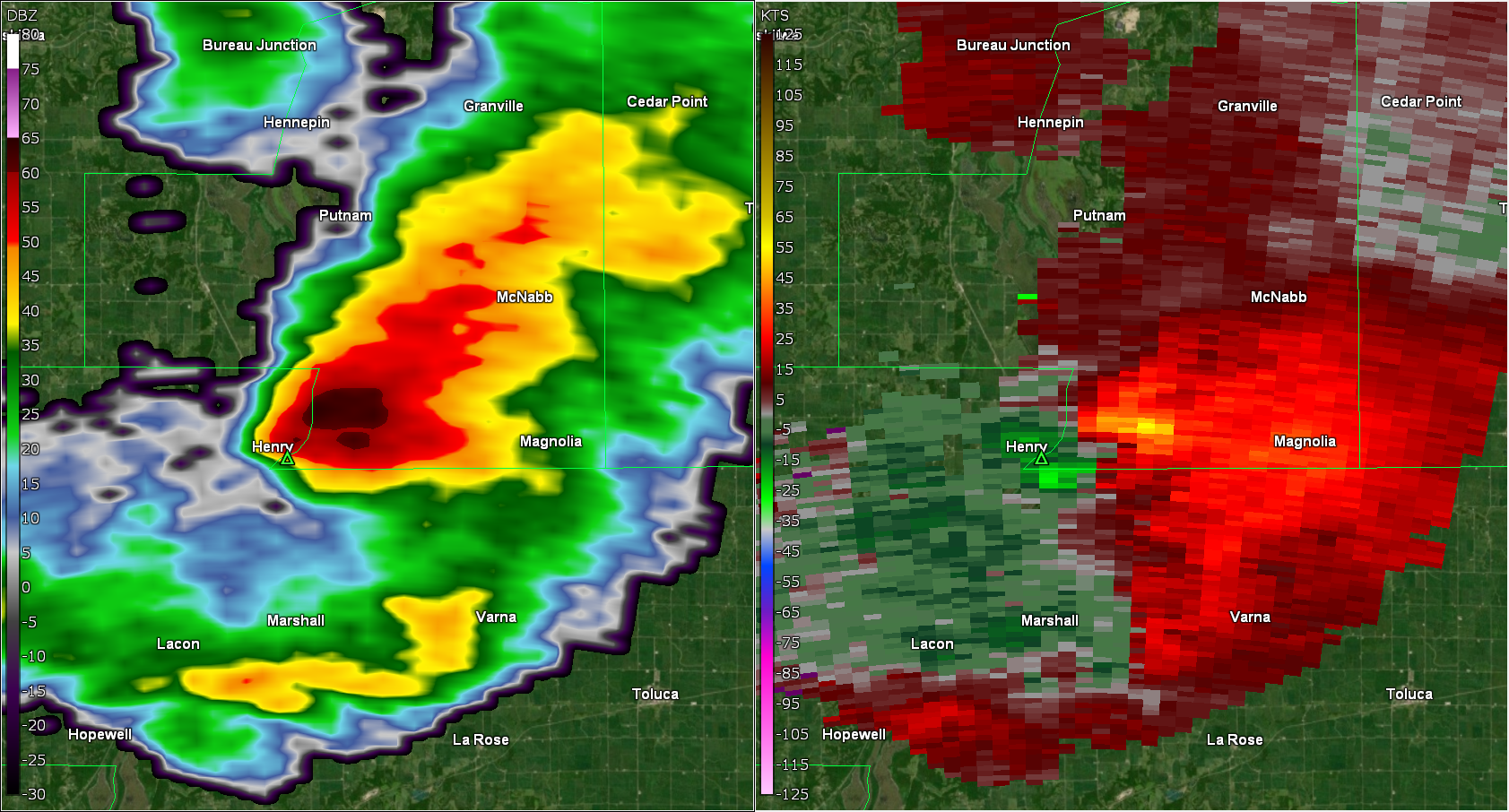
A small complex of fast-moving storms developed late in the afternoon on Thursday Feb 8th, 2024. Environmental parameters were supportive of strong storms across north-central Illinois, with a few of them developing rotation as observed by the NWS Lincoln WSR-88D doppler radar. The storms initially produced hail, with sizes ranging from peas to one inch. One storm intensified to the point of producing a tornado in northern Marshall County, around 2 miles south of Henry. The tornado moved at 45 mph to the northeast, crossing into Putnam county around 4:44 PM CST. The tornado damaged some grain bins and outbuildings along with uprooting or snapping several large trees along it's nearly 10 mile path.Tornadoes
|
Henry Tornado
|
||||||||||||||||
The Enhanced Fujita (EF) Scale classifies tornadoes into the following categories:
| EF0 Weak 65-85 mph |
EF1 Moderate 86-110 mph |
EF2 Significant 111-135 mph |
EF3 Severe 136-165 mph |
EF4 Extreme 166-200 mph |
EF5 Catastrophic 200+ mph |
 |
|||||
Radar
Header
 |
 |
 |
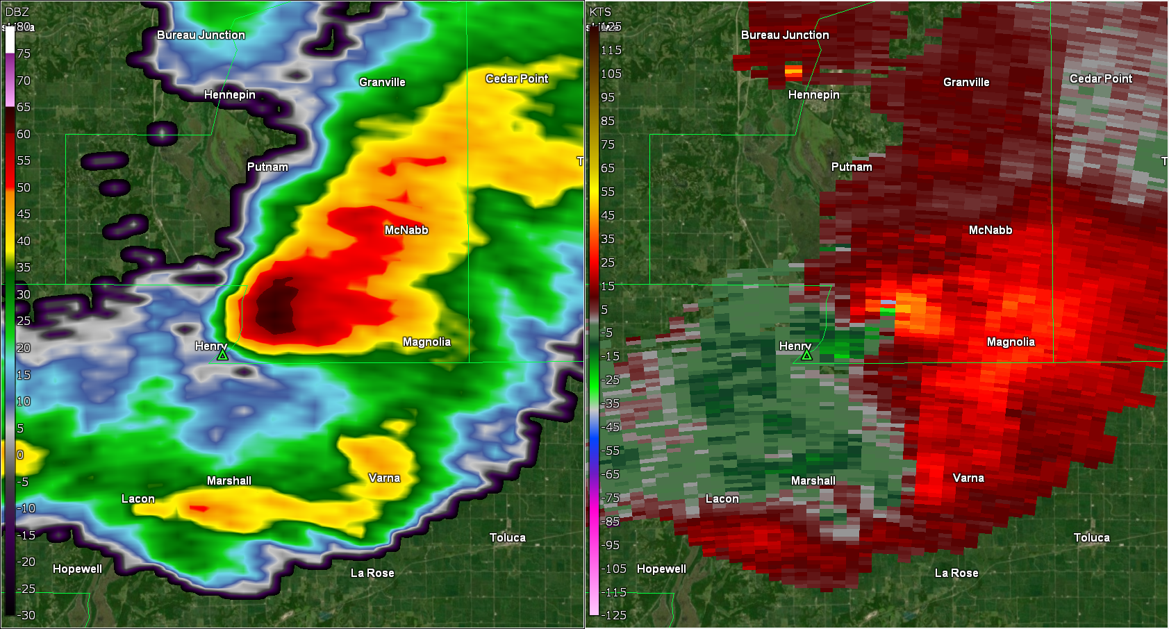 |
| 4:37 PM - 3 mins before tornado development | 4:40 PM CT - Time of tornado touchdown | 4:42 PM CT - 2 minutes after tornado touchdown | 4:44 PM CT - 4 minutes after touchdown and the time it crossed into Putnam County |
Storm Reports
NWUS53 KILX 090144
LSRILX

Preliminary Local Storm Report...Summary
National Weather Service Lincoln IL
744 PM CST Thu Feb 8 2024

..TIME...   ...EVENT...      ...CITY LOCATION...     ...LAT.LON...
..DATE...   ....MAG....      ..COUNTY LOCATION..ST.. ...SOURCE....
            ..REMARKS..

0440 PM     Tornado          2 S Henry               41.08N 89.36W
02/08/2024  EF1              Marshall           IL   NWS Storm Survey

            Tornado developed 2 miles south of Henry and
            tracked northeast through rural portions of
            northern Marshall and southeast Putnam
            Counties, damaging trees and outbuildings.
            The tornado dissipated 2 miles south of
            McNabb. Path length 9.9 miles, max width 100
            yards. Max wind speed estimated 110 mph.
            This updates previous LSR.
0541 PM     Hail             3 SE South Pekin        40.46N 89.62W
02/08/2024  E0.88 inch       Tazewell           IL   Emergency Mngr


0540 PM     Hail             Metamora                40.79N 89.36W
02/08/2024  E0.88 inch       Woodford           IL   Emergency Mngr


0530 PM     Hail             Manito                  40.43N 89.78W
02/08/2024  E0.88 inch       Mason              IL   Broadcast Media

            Pea to nickel size hail.

0520 PM     Hail             Bellevue                40.69N 89.68W
02/08/2024  E1.00 inch       Peoria             IL   Public


0517 PM     Hail             Havana                  40.30N 90.06W
02/08/2024  E0.70 inch       Mason              IL   Public

            Photo from social media.

0510 PM     Hail             Mapleton                40.57N 89.73W
02/08/2024  E1.00 inch       Peoria             IL   Broadcast Media

            Time estimated from radar.

0453 PM     Tstm Wnd Gst     Marshall County Airport 41.02N 89.39W
02/08/2024  M63 MPH          Marshall           IL   AWOS

            REPORTED AT KC75.

0445 PM     Hail             Saint David             40.49N 90.05W
02/08/2024  M0.75 inch       Fulton             IL   Public


0442 PM     Tornado          2 S Henry               41.08N 89.36W
02/08/2024                   Marshall           IL   Broadcast Media

            Brief touchdown in open field.

0442 PM     Hail             Henry                   41.11N 89.36W
02/08/2024  E0.75 inch       Marshall           IL   Trained Spotter


0419 PM     Hail             5 SE Camp Grove         41.03N 89.55W
02/08/2024  E0.75 inch       Marshall           IL   Public

            Report from mPING: Dime (0.75 in.).

0351 PM     Hail             Brimfield               40.84N 89.88W
02/08/2024  E0.75 inch       Peoria             IL   Public

            Report from mPING: Dime (0.75 in.).

0349 PM     Hail             Brimfield               40.84N 89.88W
02/08/2024  M0.88 inch       Peoria             IL   Broadcast Media


0342 PM     Hail             1 N Galesburg           40.97N 90.36W
02/08/2024  E0.50 inch       Knox               IL   Public

            Report from mPING: Half-inch (0.50 in.).

0338 PM     Hail             Galesburg               40.95N 90.37W
02/08/2024  M0.75 inch       Knox               IL   Broadcast Media
 |
Media use of NWS Web News Stories is encouraged! Please acknowledge the NWS as the source of any news information accessed from this site. |
|