Severe thunderstorms capable of damaging winds will be possible from the Ozark Plateau east into portions of the Southeast today. Rounds of heavy thunderstorms ahead of a slow moving front will continue locally heavy rainfall and scattered flash flooding potential from the Ozarks to the Ohio and Tennessee Valleys today. Read More >
Overview
|
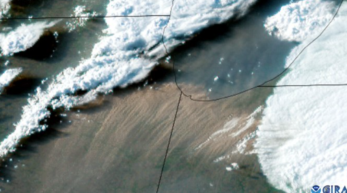
High resolution visible satellite image of dust storm, courtesy of CIRA. |
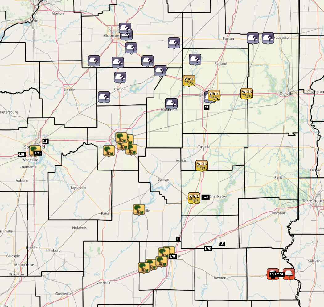
Map of severe weather and dust storm reports |
|
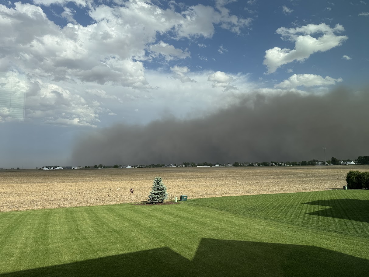
Picture of incoming dust storm from the northeast side of |
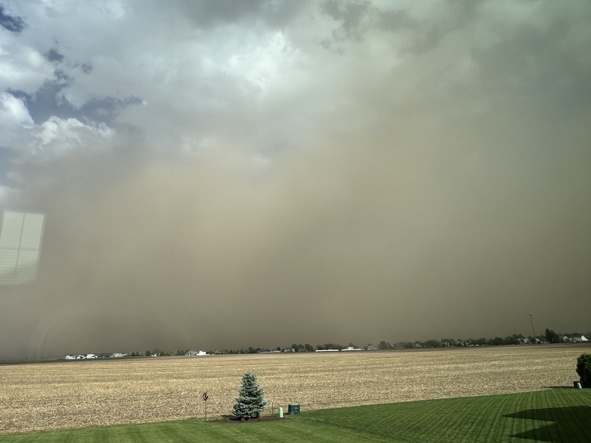
Picture of incoming dust storm from the northeast side of |
Preliminary Local Storm Report...Summary
National Weather Service Lincoln IL
844 PM CDT Fri May 16 2025

..TIME...   ...EVENT...      ...CITY LOCATION...     ...LAT.LON...
..DATE...   ....MAG....      ..COUNTY LOCATION..ST.. ...SOURCE....
            ..REMARKS..

0314 PM     Hail             1 NE Curran             39.75N 89.75W
05/16/2025  M0.88 Inch       Sangamon           IL   Trained Spotter

            Near the Wabash Ave exit on I-72.

0316 PM     Tstm Wnd Dmg     1 NNE Southern View     39.77N 89.64W
05/16/2025                   Sangamon           IL   Utility Company

            Power poles were broken and power lines were
            blown down in the Harvard Park neighborhood.

0317 PM     Hail             2 ENE Southern View     39.76N 89.62W
05/16/2025  M1.75 Inch       Sangamon           IL   Trained Spotter


0320 PM     Hail             1 SW Riverton           39.83N 89.56W
05/16/2025  M1.50 Inch       Sangamon           IL   Trained Spotter

            Near Camp Butler National Cemetery.

0349 PM     Tstm Wnd Dmg     Shelbyville             39.41N 88.81W
05/16/2025                   Shelby             IL   Broadcast Media

            Several large tree limbs were blown down.

0354 PM     Non-Tstm Wnd Dmg Mattoon                 39.48N 88.37W
05/16/2025                   Coles              IL   Emergency Mngr

            Multiple power lines were blown down across
            Mattoon.

0400 PM     Non-Tstm Wnd Dmg Arcola                  39.68N 88.31W
05/16/2025                   Douglas            IL   Public

            A few trees were blown down.

0402 PM     Tstm Wnd Dmg     Boody                   39.77N 89.05W
05/16/2025                   Macon              IL   Emergency Mngr

            A car lot roof was partially blown off and
            multiple trees were blown down.

0404 PM     Non-Tstm Wnd Gst Willard Airport         40.04N 88.27W
05/16/2025  M69 MPH          Champaign          IL   ASOS


0411 PM     Dust Storm       2 WSW Urbana            40.10N 88.24W
05/16/2025                   Champaign          IL   Broadcast Media

            Shared camera footage from on top of
            Memorial Stadium in Champaign looking due
            West of a dense, large wall of dust outside
            of town. Reports of zero visibility from
            this dust cloud.

0414 PM     Tstm Wnd Dmg     2 W Decatur Airport     39.84N 88.90W
05/16/2025                   Macon              IL   Emergency Mngr

            *** 1 INJ ***
            A tree fell onto a house on Bayview Drive.
            One person sustained a head injury.

0415 PM     Non-Tstm Wnd Dmg Urbana                  40.11N 88.21W
05/16/2025                   Champaign          IL   Broadcast Media

            A tree was blown down.

0415 PM     Tstm Wnd Dmg     Mount Zion              39.78N 88.87W
05/16/2025                   Macon              IL   Public

            A flag pole was snapped.

0415 PM     Tstm Wnd Dmg     2 SSE Decatur           39.81N 88.94W
05/16/2025                   Macon              IL   Public

            Multiple trees were blown down near Lake
            Decatur.

0415 PM     Tstm Wnd Dmg     1 NE Decatur            39.85N 88.95W
05/16/2025                   Macon              IL   Emergency Mngr

            Numerous tree branches and power lines were
            blown down across Decatur.

0418 PM     Dust Storm       2 SW White Heath        40.06N 88.55W
05/16/2025                   Piatt              IL   Broadcast Media

            Reported a video of dense blowing dust along
            I-72 east of Monticello. Visibility near
            zero within the cloud.

0420 PM     Non-Tstm Wnd Dmg Mahomet                 40.20N 88.41W
05/16/2025                   Champaign          IL   Trained Spotter

            A few trees were damaged.

0425 PM     Non-Tstm Wnd Dmg 1 NE Ogden              40.12N 87.95W
05/16/2025                   Champaign          IL   Emergency Mngr

            Several semis were blown over on I-74 near
            Ogden.

0443 PM     Dust Storm       Kenney                  40.10N 89.09W
05/16/2025                   De Witt            IL   Emergency Mngr

            Emergency manager reports little to no
            visibility around Kenney due to blowing
            dust.

0443 PM     Dust Storm       Wapella                 40.22N 88.96W
05/16/2025                   De Witt            IL   Emergency Mngr

            Emergency manager reports little to no
            visibility around Wapella due to blowing
            dust.

0445 PM     Dust Storm       1 ESE East Lynn         40.46N 87.78W
05/16/2025                   Vermilion          IL   Public

            Emergency manager reports one half to one
            quarter mile of visibility on Route 9
            between Rankin and Hoopeston.

0446 PM     Tstm Wnd Dmg     2 SW Altamont           39.05N 88.77W
05/16/2025                   Effingham          IL   Emergency Mngr

            Tree branches were blown across Route 40
            southwest of Altamont.

0448 PM     Tstm Wnd Dmg     2 E Altamont            39.07N 88.71W
05/16/2025                   Effingham          IL   Emergency Mngr

            A power line was blown down at Route 40 and
            500th Street.

0451 PM     Dust Storm       2 SE Le Roy             40.32N 88.74W
05/16/2025                   McLean             IL   Public

            Reports that Interstate 74 is closed from
            Downs to Mansfield due to no visibility in
            dense, blowing dust.

0451 PM     Dust Storm       Mclean                  40.32N 89.17W
05/16/2025                   McLean             IL   Emergency Mngr

            Reporting multiple 911 calls regarding low
            to zero visibility in McLean.

0452 PM     Dust Storm       Downs                   40.40N 88.87W
05/16/2025                   McLean             IL   Broadcast Media

            Relayed a video of a very large and very
            dense wall of dust moving into the town.
            Visibility appears to be non-existent.

0452 PM     Dust Storm       Heyworth                40.31N 88.98W
05/16/2025                   McLean             IL   Broadcast Media

            Relayed a video of a very large and very
            dense wall of dust moving into the town.
            Visibility appears to be non-existent.

0453 PM     Tstm Wnd Dmg     4 SE Shumway            39.14N 88.61W
05/16/2025                   Effingham          IL   Public

            Power lines were blown down across Lake Sara
            Road.

0453 PM     Dust Storm       Central Illinois Airpor 40.48N 88.91W
05/16/2025                   McLean             IL   ASOS

            KBMI reported one quarter mile visibility
            and blowing dust at 2153 UTC with a 51 knot
            wind gust. This limited visibility was
            reported until 2205 UTC.

0455 PM     Dust Storm       1 N Farmer City         40.26N 88.64W
05/16/2025                   De Witt            IL   Public

            Emergency manager reported a multiple
            vehicle accident on I-74 just outside of
            Farmer City, with zero visibility still
            being reported.

0456 PM     Dust Storm       3 SSW Towanda           40.52N 88.92W
05/16/2025                   McLean             IL   NWS Employee

            Relayed photos of a very large and very
            dense wall of dust moving into the town.
            Visibility appears to be non-existent.

0457 PM     Tstm Wnd Dmg     5 WSW Effingham         39.09N 88.63W
05/16/2025                   Effingham          IL   Emergency Mngr

            Power lines were blown down at Route 40 and
            900th Street.

0457 PM     Tstm Wnd Dmg     2 NNW Effingham         39.15N 88.57W
05/16/2025                   Effingham          IL   Emergency Mngr

            A power line was blown down at Lakewood
            Manor.

0459 PM     Dust Storm       Rankin                  40.46N 87.90W
05/16/2025                   Vermilion          IL   Emergency Mngr

            Stop sign was snapped off post at the
            intersection of Routes 9 and 49.

0459 PM     Dust Storm       Rankin                  40.46N 87.90W
05/16/2025                   Vermilion          IL   Emergency Mngr

            Power outages reported.

0500 PM     Hail             Robinson                39.01N 87.74W
05/16/2025  E3.00 Inch       Crawford           IL   Emergency Mngr


0500 PM     Hail             Robinson                39.01N 87.74W
05/16/2025  E2.75 Inch       Crawford           IL   Public


0500 PM     Hail             1 NNE Robinson          39.02N 87.73W
05/16/2025  M2.00 Inch       Crawford           IL   Mesonet


0503 PM     Dust Storm       Saybrook                40.43N 88.53W
05/16/2025                   McLean             IL   Emergency Mngr

            Reports of power outages due to multiple
            lines down.

0505 PM     Funnel Cloud     Robinson                39.01N 87.74W
05/16/2025                   Crawford           IL   Emergency Mngr


0505 PM     Hail             2 W Robinson Municipal  39.01N 87.68W
05/16/2025  E2.75 Inch       Crawford           IL   Storm Chaser


0509 PM     Hail             Robinson                39.00N 87.74W
05/16/2025  M1.00 Inch       Crawford           IL   Law Enforcement


0516 PM     Funnel Cloud     Palestine               39.01N 87.61W
05/16/2025                   Crawford           IL   Trained Spotter


0520 PM     Dust Storm       1 NW Fisher             40.33N 88.36W
05/16/2025                   Champaign          IL   Public

            Video of blowing dust outside of Fisher with
            less than half mile visibility.

0533 PM     Hail             1 N Coles County Airpor 39.49N 88.28W
05/16/2025  E1.25 Inch       Coles              IL   Public


0549 PM     Hail             Sigel                   39.23N 88.50W
05/16/2025  E1.00 Inch       Shelby             IL   Public

            Broadcast media relayed viewer report of
            quarter sized hail in Sigel.

0549 PM     Hail             Effingham               39.12N 88.54W
05/16/2025  E1.75 Inch       Effingham          IL   Public

            Broadcast media relayed viewer report of
            golf ball sized hail in Effingham.

0610 PM     Hail             3 SSW Jewett            39.17N 88.26W
05/16/2025  E1.75 Inch       Cumberland         IL   Public


0616 PM     Hail             3 S Greenup             39.20N 88.15W
05/16/2025  E1.50 Inch       Cumberland         IL   Public


&&

$$