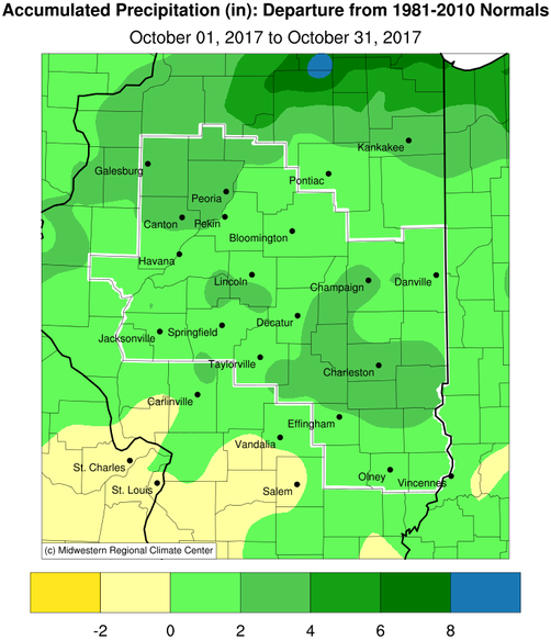
October Precipitation Highlights:
- October was the first month to see widespread, significantly above normal rainfall since April across central and southeast Illinois. An active weather pattern brought several weather systems which produced moderate to locally heavy rainfall. Rain totals of 4 to 6 inches were common, which was around 2 to 3 inches above normal. This helped alleviate drought conditions which had strengthened across the region through the summer and into early fall. By the end of the month, the U.S. Drought Monitor showed only isolated pockets of drought persisting in a narrow corridor from Jacksonville, east towards Paris.
- One severe weather event affected the area. A slow-moving cold front interacting with an unseasonably warm and humid airmass triggered several rounds of showers and thunderstorms across central Illinois on October 14th. The strongest storms impacted locations along and northwest of the Illinois River during the evening, producing wind gusts of 60-70 mph, hail up to penny-sized, and heavy rainfall. Numerous large tree branches were blown down across Galesburg. In addition, 2-3 inches of rain produced flash flooding in Galesburg, where several cars were reported stranded in high water. As the nearly stationary front began pushing eastward, the storms eventually spread toward the I-55 corridor and weakened by midnight. Before the storms completely weakened, one gusty cell knocked numerous tree branches down just south of Ashland in Morgan County, while another blew 6 power poles down northwest of Lincoln.
- Peoria recorded its 6th wettest October with 5.29".
- The first snowflakes of the season were reported on the 28th, with a trace of snow reported over much of central Illinois.
 |
 |
| October Rainfall |
October Rainfall Departure from Normal |
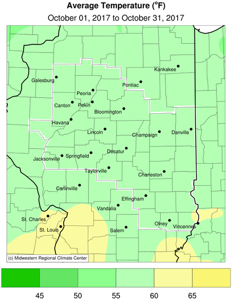
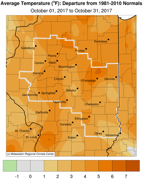
October Temperature Highlights:
- The warm weather pattern in September continued into much of October. Daily temperatures were 5 to 15 degrees above normal for the first 3 weeks of the month. Several record highs were broken on the 14th when readings reached the middle to upper 80s. A major pattern shift occurred for the last third of the month, which resulted in most days seeing daily temperatures 5 to 15 degrees below normal. Overall, the monthly temperature averaged 3 to 6 degrees above normal across the region.
- The first widespread freeze of the fall occurred on the morning of the 29th. Lows in the low to mid 20s were common west of I-57, while temperatures east of I-57 fell below freezing on the 31st. This ended the growing season at around 210-220 days, since the last widespread freeze in late March.
 |
 |
| October Average Temperature |
October Temperature Departure from Normal |
Climatological Statistics:
The following links are the monthly and seasonal climate summaries for area cities. Only the summaries for Peoria, Springfield, and Lincoln are considered "official", meaning they are the station of record for their respective locations. The other summaries are "supplemental", meaning another location in the area is the official climate station for the city.
Climate data for other cities is available at http://w2.weather.gov/climate/xmacis.php?wfo=ilx

