.
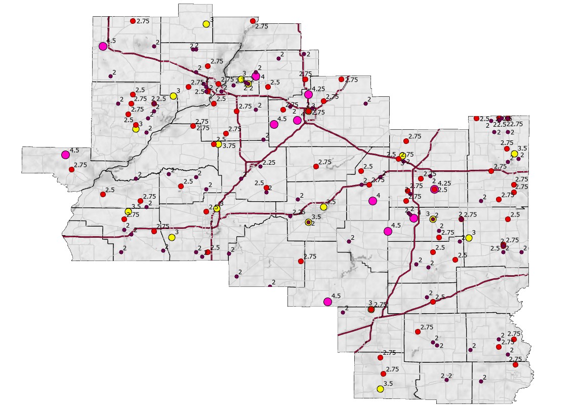
Map of 2" or larger size hail reports 1955-2022. Click image to enlarge.
Approximate hail sizes as compared to objects. Dimensions refer to the diameter of the object. When very large hail is observed, it is desirable to use a ruler or tape measure for an exact measurement.
| Size | Object |
| 2.00" | Lime or navel orange |
| 2.25" | Standard billiard ball |
| 2.50" | Tennis ball |
| 2.75" | Baseball |
| 3.00" | Large orange |
| 3.50" | Croquet ball |
| 4.00" | Softball |
| 4.50" | Grapefruit |
| 4.75" | DVD disc |
Specific details on these occurrences can be found at the National Centers for Environmental Prediction's Storm Events Database.
These are the largest hailstones (3" diameter or larger) with the Lincoln NWS coverage area of central and southeast Illinois since 1955 (28 reports).
| 4.50" Diameter | |
| May 9, 1995 | Galesburg (Knox County) |
| April 7, 1998 | Arthur (Douglas County) |
| May 12, 1998 | Littleton (Schuyler County) |
| April 10, 2001 | Cowden (Shelby County) |
| May 9, 2003 | Stanford (McLean County) |
| 4.25" Diameter | |
| July 13, 2004 | Hudson (McLean County) |
| May 30, 2008 | Philo (Champaign County) |
| 4.00" Diameter | |
| August 26, 2000 | Bement (Piatt County) |
| May 21, 2014 | 1 mile west-northwest of Tuscola (Douglas County) |
| May 30, 2004 | Metamora (Woodford County) |
| November 17, 2013 | 2 miles northeast of Covell (McLean County) |
| April 4, 2023 | Bernadotte (Fulton County) |
| 3.75" Diameter | |
| August 18, 2001 | San Jose (Logan County) |
| 3.50" Diameter | |
| June 23, 1960 | Oreana (Macon County) |
| May 5, 1977 | Literberry (Morgan County) |
| June 29, 2012 | 3 miles south-southwest of Bismarck (Vermilion County) |
| 3.25" Diameter | |
| April 4, 2023 | 1 mile east-southeast of Table Grove (Fulton County) |
| May 7, 2023 | Chatham (Sangamon County) |
| 3.00" Diameter | |
| June 6, 1971 | 5 miles north of Effingham (Effingham County) |
| June 13, 1975 | 8 miles northeast of Canton (Fulton County) |
| April 9, 2001 | Castleton (Stark County) |
| May 28, 2003 | 4 miles northwest of Washington (Tazewell County) |
| April 16, 2006 | Normal (McLean County |
| May 24, 2006 | St. David (Fulton County) |
| May 30, 2008 | 3 miles west of Loami (Sangamon County) |
| May 21, 2014 | Camargo (Douglas County) |
| April 9, 2015 | 2 miles northeast of Mahomet (Champaign County) |
| May 1, 2016 | 3 miles south of Brocton (Edgar County) |
| April 8, 2020 | 1 mile west of Devereux Heights (Sangamon County) |
| August 20, 2022 | Washington (Tazewell County) |
The largest officially documented hailstone in Illinois was 4.75" in diameter, occurring at Minooka on June 10, 2015. While determining the validity of this report, the State Climate Extremes Committee, operating within the National Centers for Environmental Information, investigated a previous report of 6" diameter hail at Kankakee on April 23, 1961. It was determined that this measurement could not be reasonably validated or verified, based on synoptic weather conditions that occurred across the area on that date.
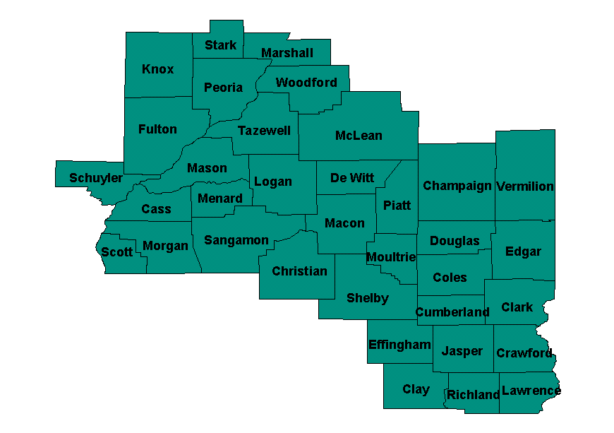
All reports of hail of at least 2" in diameter, broken up by county:
|
Cass County (3 reports) |
||
| Size | Location | Date |
| 2.75" | Philadelphia | May 5, 1977 |
| 2.50" | 2 miles southwest of Bluff Springs | June 10, 2018 |
| 2.00" | 4 miles west of Ashland | March 21, 1966 |
| Champaign County (11 reports) | ||
| Size | Location | Date |
| 4.25" | Philo | May 30, 2008 |
| 3.00" | 2 miles northeast of Mahomet | April 9, 2015 |
| 2.75" | Mahomet | May 6, 1961 |
| 2.75" | 3 miles south of Sadorus | May 18, 2000 |
| 2.75" | 3 miles south of Champaign | May 18, 2000 |
| 2.75" | Fisher | March 12, 2006 |
| 2.75" | 1 mile north-northeast of Sadorus | May 30, 2008 |
| 2.50" | Philo | May 30, 2008 |
| 2.25" | 2 miles southeast of Mahomet | April 9, 2015 |
| 2.00" | Pesotum | May 18, 2000 |
| 2.00" | 2 miles east of Sadorus | May 30, 2008 |
|
Christian County (5 reports) |
||
| Size | Location | Date |
| 2.75" | Assumption | November 17, 2013 |
| 2.50" | 5 miles southeast of Morrisonville | May 7, 2023 |
| 2.00" | 2 miles southwest of Sicily | April 7, 1998 |
| 2.00" | 1 mile west of Morrisonville | May 1, 2002 |
| 2.00" | 5 miles west-southwest of Rosamond | May 3, 2021 |
|
Clay County (4 reports) |
||
| Size | Location | Date |
| 2.75" | Louisville | September 19, 1986 |
| 2.75" | Hord | May 25, 1989 |
| 2.75" | 5 miles south of Xenia | May 3, 1996 |
| 2.50" | 1 mile west of Flora | April 24, 2002 |
|
Coles County (5 reports) |
||
| Size | Location | Date |
| 2.50" | Fairgrange | July 9, 1992 |
| 2.50" | Ashmore | July 9, 1992 |
| 2.00" | Mattoon | November 15, 1955 |
| 2.00" | Charleston | May 14, 2003 |
| 2.00" | 2 miles east of Oakland | May 1, 2016 |
|
Crawford County (6 reports) |
||
| Size | Location | Date |
| 2.75" | New Hebron | May 25, 1989 |
| 2.75" | Robinson | July 20, 1990 |
| 2.75" | 2 miles west of Palestine | July 20, 1990 |
| 2.00" | Robinson | June 24, 1985 |
| 2.00" | 5 miles south of Oblong | June 26, 2006 |
| 2.00" | Flat Rock | June 18, 2009 |
|
Cumberland County (2 reports) |
||
| Size | Location | Date |
| 2.50 | Greenup | May 11, 2014 |
| 2.00 | 3 miles northwest of Greenup | May 11, 2014 |
|
De Witt County (1 report) |
||
| Size | Location | Date |
| 2.75" | 3 miles southwest of Clinton | May 28, 2003 |
|
Douglas County (10 reports) |
||
| Size | Location | Date |
| 4.50" | Arthur | April 7, 1998 |
| 4.00" | 1 mile west-northwest of Tuscola | May 21, 2014 |
| 3.00" | Camargo | May 21, 2014 |
| 2.75" | Newman | April 10, 1981 |
| 2.75" | Hindsboro | July 4, 1985 |
| 2.00" | 3 miles northwest of Tuscola | May 21, 2014 |
| 2.00" | Camargo | May 25, 1989 |
| 2.00" | Newman | April 19, 1996 |
| 2.00" | 4 miles northwest of Tuscola | May 21, 2014 |
| 2.00" | 3 miles north of Hindsboro | May 21, 2014 |
|
Edgar County (7 reports) |
||
| Size | Location | Date |
| 3.00" | 3 miles south of Brockton | May 1, 2016 |
| 2.75" | 1 mile north of Paris | May 10, 2003 |
| 2.50" | Chrisman | July 21, 2008 |
| 2.50" | Paris | April 10, 2013 |
| 2.00" | 2 miles south of Paris | May 30, 2004 |
| 2.00" | Paris | April 10, 2013 |
| 2.00" | Vermilion | March 28, 2020 |
|
Effingham County (3 reports) |
||
| Size | Location | Date |
| 3.00" | 5 miles north of Effingham | May 6, 1971 |
| 2.75" | 4 miles east-northeast of Shumway | November 15, 1955 |
| 2.00" | Beecher City | September 30, 1977 |
|
Fulton County (14 reports) |
||
| Size | Location | Date |
| 4.00" | Bernadotte | April 4, 2023 |
| 3.25" | 1 mile east-southeast of Table Grove | April 4, 2023 |
| 3.00" | 8 miles northeast of Canton | June 13, 1975 |
| 3.00" | St. David | May 24, 2006 |
| 2.75" | Cuba | July 21, 2008 |
| 2.75" | Fiatt | July 21, 2008 |
| 2.75" | Vermont | April 4, 2023 |
| 2.75" | Table Grove | April 4, 2023 |
| 2.50" | Canton | April 10, 2017 |
| 2.00" | Canton | April 10, 2017 |
| 2.00" | Blyton | June 14, 1974 |
| 2.00" | 1 mile east of Bryant | May 24, 2006 |
| 2.00" | 1 mile north of Dunfermline | May 24, 2006 |
| 2.00" | 4 miles east-southeast of Lewistown | June 4, 2010 |
|
Jasper County (3 reports) |
||
| Size | Location | Date |
| 2.75" | 2 miles east of Wheeler | May 25, 1989 |
| 2.00" | Newton | June 24, 1985 |
| 2.00" | 2 miles southeast of Newton | June 21, 2009 |
|
Knox County (4 reports) |
||
| Size | Location | Date |
| 4.50" | Galesburg | May 9, 1995 |
| 2.75" | Altona | April 13, 2006 |
| 2.00" | Williamsfield | April 30, 1973 |
| 2.00" | Hermon | June 14, 1974 |
|
Lawrence County (2 reports) |
||
| Size | Location | Date |
| 2.75" | 3 miles east of Birds | May 31, 1998 |
| 2.00" | Sumner | January 17, 2012 |
|
Logan County (5 reports) |
||
| Size | Location | Date |
| 3.75" | San Jose | August 18, 2001 |
| 2.50" | Mount Pulaski | August 13, 2011 |
| 2.25" | Logan County Airport | May 9, 1995 |
| 2.00" | Broadwell | May 12, 2000 |
| 2.00" | 2 miles south of Mount Pulaski | July 26, 1978 |
|
Macon County (4 reports) |
||
| Size | Location | Date |
| 3.50" | Oreana | June 22, 1960 |
| 2.25" | 4 miles southeast of Niantic | April 18, 1996 |
| 2.00" | Decatur | April 22, 1963 |
| 2.00" | Warrensburg | August 17, 2000 |
|
Marshall County (1 report) |
||
| Size | Location | Date |
| 2.75" | Varna | April 9, 2001 |
|
Mason County (3 reports) |
||
| Size | Location | Date |
| 2.75" | Manito | December 8, 1991 |
| 2.75" | Manito | August 18, 2001 |
| 2.00" | Kilbourne | April 4, 2003 |
|
McLean County (11 reports) |
||
| Size | Location | Date |
| 4.50" | Stanford | May 9, 2003 |
| 4.25" | Hudson | July 13, 2004 |
| 4.00" | 2 miles northeast of Covell | November 17, 2013 |
| 3.00" | Normal | April 16, 2006 |
| 2.75" | Danvers | April 3, 1974 |
| 2.75" | 6 miles north of Lexington | March 30, 2005 |
| 2.75" | Normal | November 17, 2013 |
| 2.75" | 1 mile north of Towanda | May 11, 2014 |
| 2.50" | Danvers | May 9, 2003 |
| 2.00" | Colfax | October 17, 1988 |
| 2.00" | 2 miles south-southeast of Carlock | April 16, 2006 |
|
Menard County (4 reports) |
||
| Size | Location | Date |
| 2.50" | Petersburg | December 8, 1991 |
| 2.00" | 4 miles north-northeast of Athens | March 21, 1966 |
| 2.00" | Greenview | July 28, 1996 |
| 2.00" | 2 miles east of Oakford | April 4, 2003 |
|
Morgan County (7 reports) |
||
| Size | Location | Date |
| 3.50" | Literberry | May 5, 1977 |
| 2.75" | Alexander | March 15, 2016 |
| 2.75" | (IJX) Jacksonville Airport | May 10, 2017 |
| 2.00" | Jacksonville | April 19, 1964 |
| 2.00" | Murrayville | May 11, 1975 |
| 2.00" | 1 mile north-northwest of Waverly | April 15, 2011 |
| 2.00" | Jacksonville | March 15, 2016 |
|
Moultrie County (1 report) |
||
| Size | Location | Date |
| 2.00" | Bethany | April 7, 1998 |
|
Peoria County (9 reports) |
||
| Size | Location | Date |
| 2.75" | Peoria | June 2, 1980 |
| 2.75" | Hanna City | April 10, 1981 |
| 2.75" | Alta | July 9, 1990 |
| 2.00" | 1 mile west of Bartonville | June 4, 2002 |
| 2.00" | Kickapoo | July 26, 2002 |
| 2.00" | Norwood | May 9, 2003 |
| 2.00" | 1 mile west of Princeville | April 13, 2006 |
| 2.00" | Bellevue | June 19, 2009 |
| 2.00" | Princeville | April 19, 2011 |
|
Piatt County (5 reports) |
||
| Size | Location | Date |
| 4.00" | Bement | August 26, 2000 |
| 2.75" | Monticello | May 15, 2009 |
| 2.50" | De Land | May 28, 2019 |
| 2.00" | White Heath | May 21, 2014 |
| 2.00 | 4 miles west of Monticello | May 11, 2016 |
|
Richland County (1 report) |
||
| Size | Location | Date |
| 2.00" | Olney | June 24, 1985 |
|
Sangamon County (8 reports) |
||
| Size | Location | Date |
| 3.25" | Chatham | May 7, 2023 |
| 3.00" | 3 miles west of Loami | May 30, 2008 |
| 3.00" | Devereux Heights | April 8, 2020 |
| 2.50" | (SPI) Springfield Capital Airport | April 3, 1974 |
| 2.50" | 1 mile northwest of Divernon | May 30, 2008 |
| 2.00" | Auburn | May 27, 2002 |
| 2.00" | 3 miles west-southwest of Divernon | August 13, 2011 |
| 2.00" | Divernon | May 7, 2023 |
|
Schuyler County (2 reports) |
||
| Size | Location | Date |
| 4.50" | Littleton | May 12, 1998 |
| 2.75" | 1 mile northwest of Rushville | August 18, 1999 |
|
Shelby County (1 report) |
||
| Size | Location | Date |
| 4.50" | Cowden | April 10, 2001 |
|
Stark County(1 report) |
||
| Size | Location | Date |
| 3.00" | 2 miles southeast of Castleton | April 9, 2001 |
|
Tazewell County (10 reports) |
||
| Size | Location | Date |
| 3.00" | 4 miles northwest of Washington | May 28, 2003 |
| 3.00" | Washington | August 20, 2022 |
| 2.75" | Tremont | December 8, 1991 |
| 2.75" | Delavan | May 30, 2004 |
| 2.50" | 6 miles southwest of Delavan | August 18, 2001 |
| 2.50" | Morton | May 8, 2003 |
| 2.00" | Mackinaw | July 26, 1978 |
| 2.00" | Armington | May 9, 2003 |
| 2.00" | Washington | May 13, 2008 |
| 2.00" | Creve Coeur | July 11, 2020 |
|
Vermilion County (19 reports) |
||
| Size | Location | Date |
| 3.50" | 3 miles south-southwest of Bismarck | June 29, 2012 |
| 2.75" | 4 miles west of Bismarck | June 29, 2012 |
| 2.75" | Westville | May 16, 2019 |
| 2.75" | Oakwood | May 17, 1991 |
| 2.75" | Georgetown | May 18, 2000 |
| 2.75" | Indianola | May 18, 2000 |
| 2.75" | Hoopeston | March 20, 2017 |
| 2.50" | 3 miles west of Hoopeston | May 6, 2012 |
| 2.50" | Hoopeston | May 6, 2012 |
| 2.50" | Rankin | May 26, 2017 |
| 2.00" | 4 miles northwest of Danville | September 30, 1977 |
| 2.00" | Rossville | May 18, 2000 |
| 2.00" | Allerton | August 18, 2001 |
| 2.00" | (DNV) Vermilion Regional Airport | June 29, 2012 |
| 2.00" | Hoopeston | March 20, 2017 |
| 2.00" | 5 miles ESE Rankin | May 26, 2017 |
| 2.00" | 3 miles west of Hoopeston | May 26, 2017 |
| 2.00" | 5 miles west of Rossville | May 26, 2017 |
| 2.00" | 2 miles west of Hoopeston | May 26, 2017 |
|
Woodford County (6 reports) |
||
| Size | Location | Date |
| 4.00" | Secor | May 30, 2004 |
| 2.75" | Kappa | July 13, 2004 |
| 2.50" | 2 miles south of Eureka | May 12, 2000 |
| 2.00" | 4 miles west-northwest of Benson | June 13, 1975 |
| 2.00" | Metamora | July 26, 1978 |
| 2.00" | Minonk | May 17, 1991 |
No occurrences of hail 2" or larger have been reported in Clark or Scott Counties since 1955.

