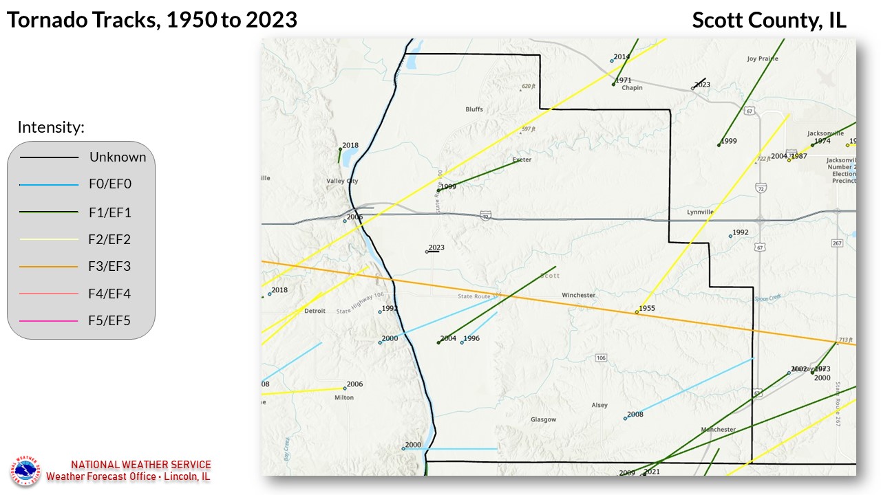
National Weather Service United States Department of Commerce


Scott County tornadoes since 1950


12 TORNADOES were reported in Scott County, Illinois between 01/01/1950 and 12/31/2022.

Click on Location or County to display Details.

Mag:
Dth:
Inj:
PrD:
CrD:
Magnitude
Deaths
Injuries
Property Damage
Crop Damage


Location  Date Time (CST) Mag Dth Inj PrD CrD
1 Winchester 08/29/1955 06:00 PM F2 0 2 250K 0
2 Winchester 04/24/1961 08:00 PM F3 0 3 250K 0
Winchester 04/19/1996 04:44 PM F0 0 0 0 0
Oxville 04/08/1999 07:07 PM F1 0 0 150K 0
Oxville 04/08/1999 07:10 PM F1 0 0 100K 0
Winchester 05/26/2000 10:15 PM F0 0 0 0 0
Glasgow 05/26/2000 10:16 PM F0 0 0 0 0
Winchester 05/24/2004 10:19 PM F1 1 1 0 0
Alsey 03/12/2006 07:28 PM F1 0 0 0 0
10 Manchester 03/12/2006 07:29 PM F2 0 0 0 0
11 Alsey 06/03/2008 07:32 PM EF0 0 0 0 0
12 Alsey 08/19/2009 01:14 PM EF1 0 0 75K 112K
TOTALS: 1 6 825K
112K

Details:
 
  1. 8/29/1955:  Approximate track from about 5 miles east of Winchester to the northwest side of Jacksonville.  12 miles long, 100 yards wide.
  2. 4/24/1961:  Bisected the entire county west to east, passing through Winchester.  Path length 16 miles, width 33 yards.
  3. 4/19/1996:  Affected areas a few miles southwest of Winchester.  Path length 2 miles, width 100 yards.  
  4. 4/08/1999:  Crossed the Illinois River from Pike County, about 5 miles southwest of Oxville, then lifted.  From Storm Data: As the tornado crossed the Illinois River from Pike County into Scott County, it caused extensive damage to a residence next to a pump house located near the river, 5 miles southwest of Oxville. The windows on the west side of the house were blown out and the east wall was blown out as well. Shortly after hitting the home the tornado lifted and dissipated. No injuries were reported and the damage was estimated around $150,000.
  5. 4/8/1999:  Formed near Oxville and travelled 4 miles, maximum width 120 yards.  From Storm DataA tornado developed 0.3 of a mile north northwest of Oxville. It took the roof off of a trailer then continued to the northeast. One mile northeast of Oxville, it destroyed a barn and three grain bins. It destroyed numerous trees and caused damage to several barns and silos before lifting and dissipating 3 miles southeast of Bluffs. No injuries were reported and damage was estimated around $100,000.
  6. 5/26/2000:  Crossed the Illinois River south of Florence, and travelled 5 miles through Scott County, passing west of Winchester.  From Storm Data: A tornado which formed along the leading edge of a bow echo touched down in Pike County 2.5 miles southeast of Detroit, then traveled to the east northeast, crossing the Illinois River south of Florence. It moved into Scott County 8 miles west southwest of Winchester, but little damage was found in the river bottoms area until the tornado moved up into the bluffs. About four miles west of Winchester, it flattened corn, uprooted several trees, snapped a couple of utility poles, damaged an outbuilding, and caused minor damage to two homes before lifting and dissipating. No injuries were reported.
  7. 5/26/2000:  Another tornado which first touched down in Pike County, then crossed into Scott County.  Path length in Scott County was 4 miles, width 70 yards.  Damaged many trees about 2 miles west-southwest of Glasgow.
  8. 5/24/2004:  On the ground for 7 miles, lifting just after moving across the north part of Winchester.  From Storm Data: The tornado initially touched down 6 miles west southwest of Winchester then traveled to the northeast causing minor tree damage. Two miles southwest of Winchester it destroyed a mobile home causing 1 fatality. The two occupants of the mobile home were thrown from the home. The husband only sustained minor injuries. As the tornado went through Winchester it weakened in intensity causing minor to moderate damage to the roofs of several homes, destroyed some sheds and blew down numerous trees.
  9. 3/12/2006:  This tornado touched down in north central Greene County, about 1.5 miles northwest of Barrow.  It moved into southern Scott County about 3 miles south-southeast of Alsey.  It moved northeast, passing about 3/4 mile northwest of Manchester, around 7:33 pm., and continued northeast, crossing the Scott/Morgan County line 2.75 miles west-southwest of Murrayville, before finally lifting near Murrayville. Total path length in the 3 counties was 9.75 miles, with a width of 75 yards.
  10. 3/12/2006:  This particular tornado was on the ground for approximately 65 miles, touching down in Pike County and finally lifting in Springfield (Sangamon County).  In Scott County, it passed through Manchester.  The path length in the county was 5 miles.
  11. 6/3/2008:  Touched down 1 mile east of Alsey, and tracked east-northeast for 7 miles without causing any damage.
  12. 6/19/2009:  This tornado initially touched down in Greene County, 3.5 miles southeast of Alsey, then moved northeast into Scott County.   It was on the ground in Scott County for 6 miles, before moving into southern Morgan County, with a total path length of 18 miles.