Overview
|
A strong spring low pressure system brought severe storms to parts of the Midwest on Easter Sunday, April 20. The day started with a warm front lifting north through the area, sparking the development of non-severe thunderstorms. A break in activity during the afternoon allowed the atmosphere to destabilize ahead of an approaching cold front. Storms developed over Missouri and tracked northeast into Illinois late in the evening. Although CAPE was only moderately strong, both strong wind shear and synoptic scale forcing supported severe storm development. A handful of thunderstorm wind damage reports were received, 60-65 mph winds were estimated by a trained spotter in Lewistown, IL, and a total of 3 tornadoes were confirmed in Knox and Tazewell counties. |
|
Tornadoes
Select a tornado from the table to zoom into the track and view more information. The default table view is limited to 8 tracks, but can be scrolled by a mouse wheel or dynamically expanded. Additionally, the table can fill the entire window by clicking the small circular expanding arrow icon at the very top right of the table and returned to its original size by clicking the button again. The side information panel that opens over the map can be closed using the "X" on the upper right corner of the pop-up. Zoom into the map and click damage points to see detailed information and pictures from the surveys.
|
NOTE: times shown below are local to your device's time zone. |

The Enhanced Fujita (EF) Scale classifies tornadoes into the following categories:
| EF0 Weak 65-85 mph |
EF1 Moderate 86-110 mph |
EF2 Significant 111-135 mph |
EF3 Severe 136-165 mph |
EF4 Extreme 166-200 mph |
EF5 Catastrophic 200+ mph |
 |
|||||
| Tornadoes that fail to impact any ratable structures on the EF-Scale are rated EF-Unknown (EF-U) | |||||
Photos & Video
Header
 |
 |
 |
|
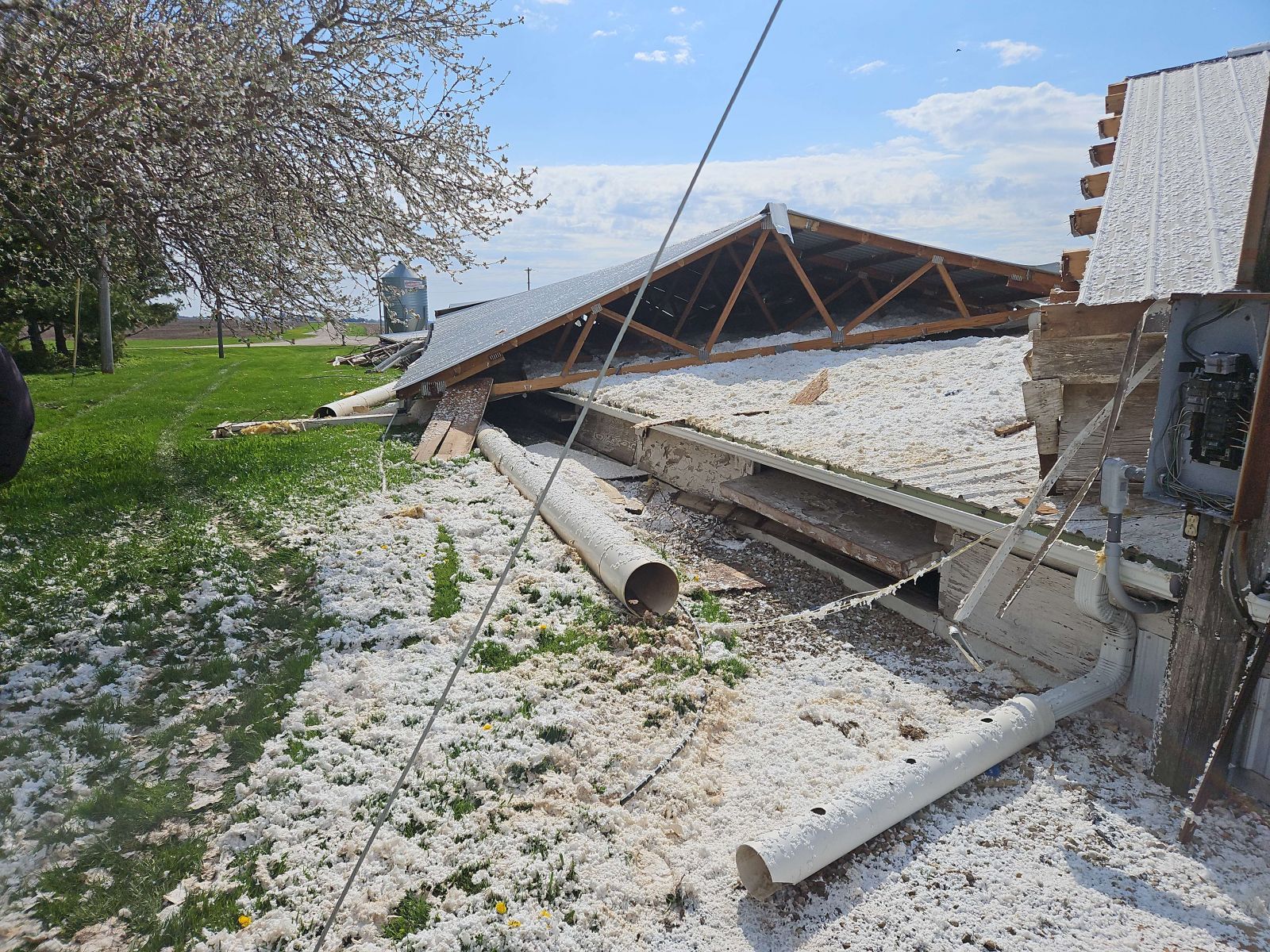
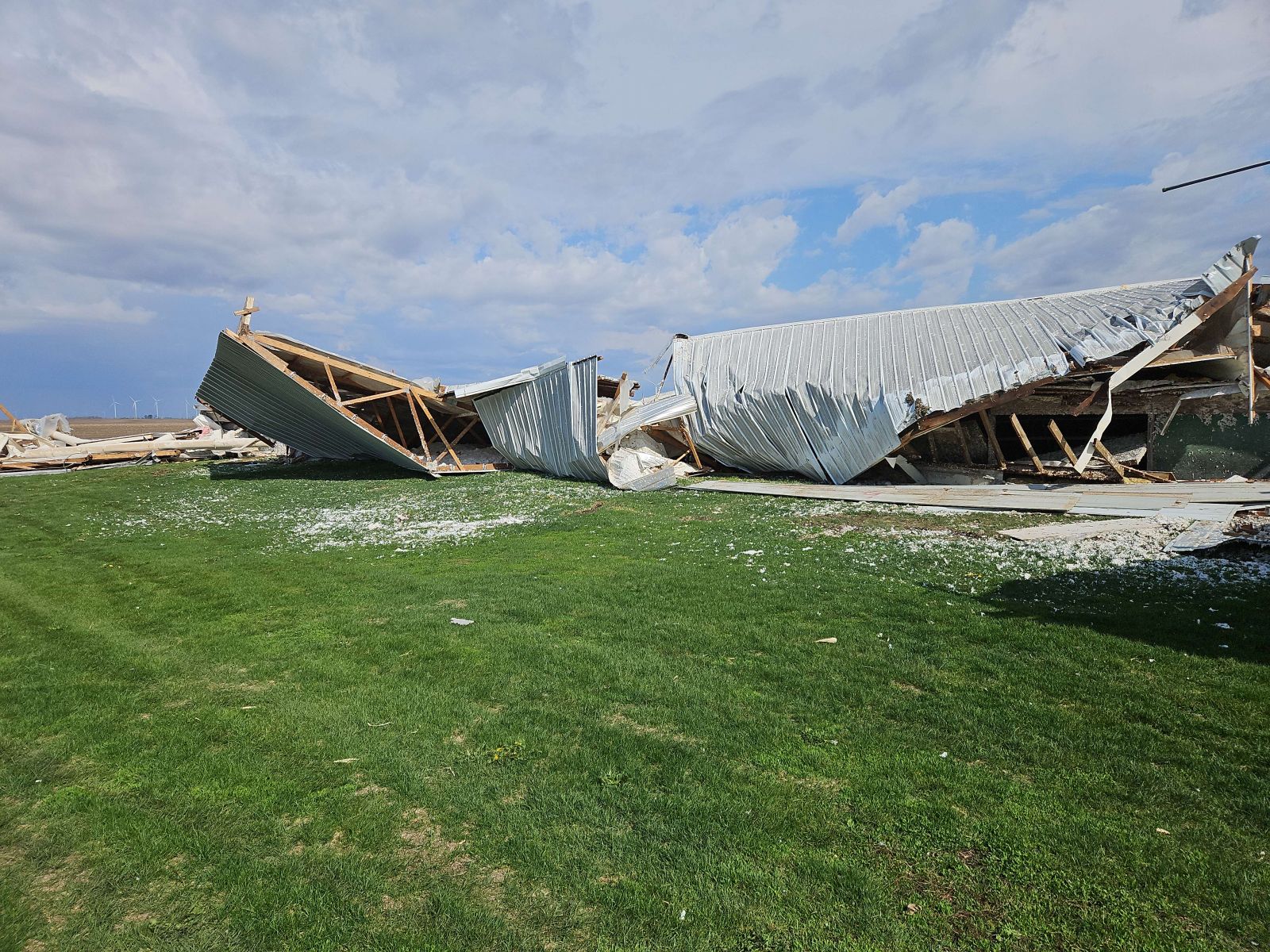
| Damage to a farm 1.5 miles northeast of Altona, IL. (NWS Damage Survey) |
Damage to a farm 1.5 miles northeast of Altona, IL. (NWS Damage Survey) |
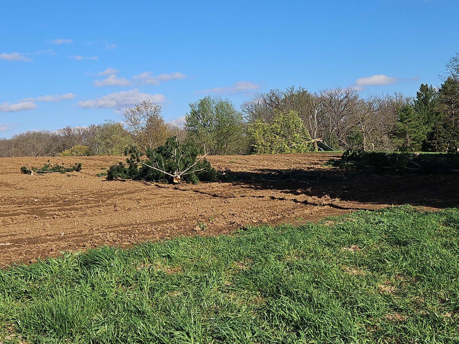
Tornadic tree damage east of Tremont, IL. (NWS Damage Survey) |
Caption (source) |
Storm Reports
Preliminary Local Storm Report...Summary
National Weather Service Lincoln IL
1059 PM CDT Tue Apr 22 2025

..TIME...   ...EVENT...      ...CITY LOCATION...     ...LAT.LON...
..DATE...   ....MAG....      ..COUNTY LOCATION..ST.. ...SOURCE....
            ..REMARKS..

0738 PM     Tstm Wnd Dmg     3 NE Bluff Springs      40.03N 90.31W
04/20/2025                   Cass               IL   Public

            Delayed report. Several poles were downed by
            thunderstorm winds. Relayed via broadcast
            media. Time estimated from radar.

0741 PM     Tstm Wnd Dmg     3 NE Astoria            40.26N 90.32W
04/20/2025                   Fulton             IL   Emergency Mngr

            Large tree down across N County 2 Hwy north
            of E Workman Rd.

0810 PM     Tstm Wnd Gst     Lewistown               40.40N 90.16W
04/20/2025  E65 MPH          Fulton             IL   Trained Spotter

            60-65 mph wind gusts reported.

0819 PM     Tstm Wnd Dmg     1 S Maquon              40.79N 90.16W
04/20/2025                   Knox               IL   Public

            Delayed report. Home playground equipment
            destroyed. Relayed via broadcast media. Time
            estimated from radar.

0825 PM     Tstm Wnd Dmg     4 SSW Easton            40.17N 89.86W
04/20/2025                   Mason              IL   Fire Dept/Rescue

            Tree down on a power line along county road
            750N.

0839 PM     Tornado          1 W Victoria            41.03N 90.12W
04/20/2025                   Knox               IL   NWS Storm Survey

            The tornado touched down west of Victoria
            and tracked 16.48 miles north-northeast
            before dissipating north of Galva. It was on
            the ground for 18 minutes and rated EF-1.

0841 PM     Tornado          1 NE Altona             41.13N 90.15W
04/20/2025                   Knox               IL   NWS Storm Survey

            The tornado touched down northeast of Altona
            and tracked 4.41 miles north before
            dissipating near Bishop Hill. It was on the
            ground for 7 minutes and was rated an EF-1.

0855 PM     Tornado          3 NE Tremont            40.56N 89.45W
04/20/2025                   Tazewell           IL   NWS Storm Survey

            The tornado affected mainly rural areas of
            Tazewell County where it produced EF-1
            damage to trees, outbuildings and power
            poles, with peak winds of 90 mph. It reached
            a width of 100 yards as it damaged and
            uprooted numerous trees and snapped a couple
            of power poles. The tornado was on the
            ground for 9.5 miles before dissipating
            about 3 miles north of Deer Creek.

0857 PM     Tstm Wnd Dmg     3 WNW Mackinaw          40.56N 89.40W
04/20/2025                   Tazewell           IL   Emergency Mngr

            6 inch diameter tree limbs down, and about a
            70 foot section of a barn wall was blown
            out.

0858 PM     Tstm Wnd Dmg     4 ESE Morton            40.58N 89.40W
04/20/2025                   Tazewell           IL   Emergency Mngr

            Top of a grain bin blown off near the
            intersection of Washington and Robinson
            Roads.

0859 PM     Tstm Wnd Dmg     2 SE Wyoming            41.04N 89.74W
04/20/2025                   Stark              IL   Public

            Soffit came loose on a house.

1022 PM     Tstm Wnd Dmg     3 WSW Flora             38.66N 88.55W
04/20/2025                   Clay               IL   Emergency Mngr

            Tree down blocking Old Highway 50 at Country
            Club Road.

1135 PM     Rain             Latham                  39.97N 89.16W
04/20/2025  M1.47 Inch       Logan              IL   Mesonet

            Storm total.

1150 PM     Rain             3 WNW Peoria            40.73N 89.65W
04/20/2025  M1.22 Inch       Peoria             IL   NWS Employee

            Since 7 am today.
Radar
Header
| Caption | Caption | Caption | Caption |
Additional Information
The Forecast
| SPC Day 3 Categorical Outlook | SPC Day 3 Probabilistic Outlook | SPC Day 2 Categorical Outlook | SPC Day 2 Probabilistic Outlook |
| SPC Day 1 Categorical Outlook | SPC Day 1 Tornado Outlook | SPC Day 1 Hail Outlook | SPC Day 1 Wind Outlook |
 |
Media use of NWS Web News Stories is encouraged! Please acknowledge the NWS as the source of any news information accessed from this site. |
|


