A slow moving front will bring rounds of strong to severe thunderstorms and heavy rainfall to the central Plains eastward to the east-central U.S.. The first widespread significant heat wave of summer for the Intermountain West and Plains is expected to develop today and expand through next week. Dangerous heat will continue to impact portions of the Southwest and Southeast. Read More >
January 7-13, 2024
Two powerful winter storm systems impacted the Midwest during the week of January 7th through January 13th...bringing high winds, heavy rain, thunderstorms, heavy snow, and blizzard conditions to parts of the region. In the wake of the second storm, a surge of bitterly cold air brought the lowest temperatures of the winter with wind-chills expected to drop to -30 to -40 by the morning of January 14th.
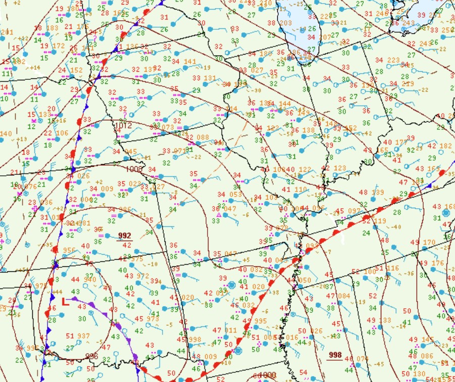
Surface analysis from the evening of Monday, January 8th showed a 992mb low over Oklahoma with a warm front extending eastward into the Tennessee River Valley. Light rain developed north of the front and gradually mixed with and changed to wet snow north of the I-70 corridor as evaporative cooling brought temperatures down into the lower to middle 30s. However as the low approached from the southwest, warmer air was drawn into the region and pushed temperatures well into the 30s to near 40 degrees overnight...resulting in a change back to rain across most locations. The exception was along and northwest of the Illinois River where the predominant precipitation type remained snow.
SURFACE WEATHER MAP 6PM CST JANUARY 8
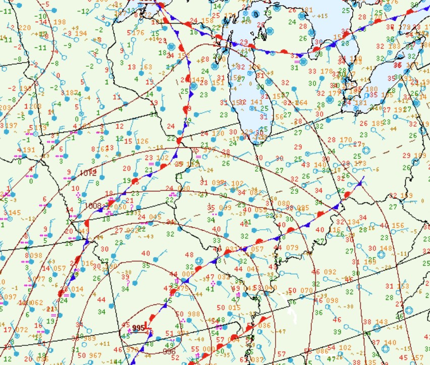
As the low tracked northeastward along the I-55 corridor on Tuesday, January 9th, most of central Illinois saw warmer temperatures in the 40s and occasional rain showers. Meanwhile to the west of the low track, snow continued across the Illinois River Valley.
SURFACE WEATHER MAP 12PM CST JANUARY 9

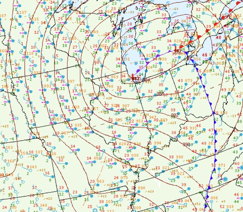
After a brief mid-week lull, the next strong storm system quickly organized over the Southern Plains and approached central Illinois from the southwest by Friday, January 12th. While computer models initially projected a more southern track that could have brought significant snow to much of the area, it became evident that this system would follow a track similar to the early week storm. The surface weather map from midnight January 12th showed a 995mb low over southwest Missouri with a stationary frontal boundary draped along the I-64 corridor. A cold rain developed north of the front during the evening of January 11th and as a pocket of warmer, more unstable air aloft lifted northward...a few thunderstorms even developed across central Illinois. Meanwhile further north where temperatures remained slightly colder, wet snow fell along and north of a Keokuk Iowa....to Peoria...to Pontiac line through much of the night.
SURFACE WEATHER MAP 12AM CST JANUARY 12
The low then tracked northeastward along the I-57 corridor during the day Friday. Thanks to southerly flow to the right of the low track, high temperatures climbed well into the 40s across eastern Illinois and hit 50 degrees around Olney and Lawrenceville. Heavy rainfall accompanied the system as well, particularly along and east of I-57 where amounts of 1 to 1.50 were common. Enough warm air was drawn westward to change the precipitation over to rain across the colder Illinois River Valley...with snow persisting throughout the day further northwest closer to the Mississippi River.
SURFACE WEATHER MAP 12AM CST JANUARY 13
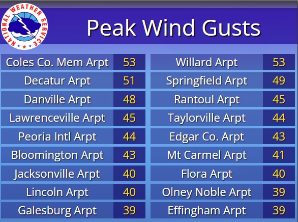
As the low lifted into the southern Great Lakes, very strong westerly winds developed by the late afternoon and evening of Friday, January 12th. Wind gusts exceeded 40mph...with a few spots topping 50mph. The highest observed gusts were 53mph at both the Champaign and Mattoon airports. The westerly winds brought sharply colder air into the region, resulting in temperatures plummeting into the teens and lower 20s by the morning of January 13th. Additional snow-showers pivoted through the region as the low tracked further away, with light snow accumulations of under 1 inch observed as far south as the I-70 corridor.
PEAK WIND GUSTS JANUARY 12
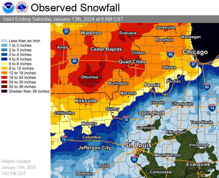
Thanks to the ferocious winds over fresh snow cover, blizzard conditions developed across Iowa into northwest Illinois where blowing snow cut visibilities to one quarter of a mile or less at times. Once the second system departed, parts of the region were buried under a significant snow cover. Storm total snowfall from the past week exceeded 8 inches along and northwest of a Quincy...to Peoria...to Watseka line. Even higher totals of 18 to 24 inches were observed further northwest near the Mississippi River along and northwest of a Burlington, Iowa to Kewanee line. Within the NWS Lincoln County Warning Area (CWA), the highest total of 20.3 inches was measured by an observer in Altona in far northern Knox County. Meanwhile Peoria picked up 10.7 inches while parts of northern Fulton County into Woodford County got as much as 7 to 9 inches. Amounts decreased sharply further southeast...with 1 inch or less everywhere along and south of the I-72 corridor.
JANUARY 8-13 STORM TOTAL SNOWFALL