February 8-9, 2010
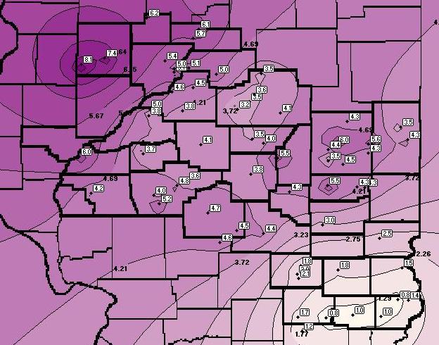
A winter storm impacted central and southeast Illinois on February 8th and 9th, bringing widespread snow. As was often the case during the winter of 2009-2010, the track of the system allowed the heaviest snow to fall across the Illinois River Valley, with lighter amounts further east and south. By the time the snow tapered off and came to an end on February 9th, a few locations northwest of the Illinois River across Knox and Stark counties had picked up between 6 and 8 inches. Further east, much of the remainder of the region received 3 to 5 inches, with only around 1 inch being reported south of I-70.
A split flow regime was in place across the U.S. on February 8th, with the main branch of the jet stream located well to the south across southern Texas into the Gulf of America. Meanwhile, a second branch of the jet dropped out of Canada into the Plains. At the surface, two separate areas of low pressure were noted. The primary low in association with the strong 160mph southern jet stream was located over Texas, while a second low was analyzed over the Upper Midwest in conjunction with the northern jet. As these two lows moved eastward, snow developed and spread into Illinois on February 8th. The snow became heavier and more widespread during the night of February 8th as the northern stream jet approached from the west and enhanced synoptic lift across the area. A punch of dry air wrapping around the northern system arrived during the morning of February 9th, essentially bringing an end to the snow across much of central Illinois. Further north, light snow lingered throughout the day across parts of the Illinois River Valley into northern Illinois.
Below is a map of all SWOP reports collected during this storm.



 Follow us on X
 Follow us on Facebook
 Follow us on YouTube
 ILX RSS Feed