Central Illinois
Weather Forecast Office
February 24-25, 2011
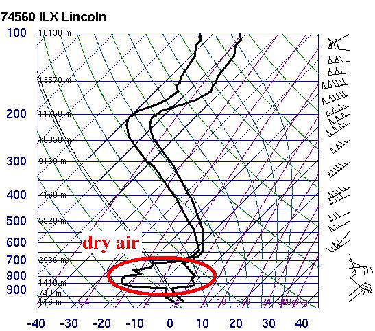
A deepening area of low pressure tracking from the Ozarks into the Ohio River Valley brought a period of snow to central Illinois during the night of February 24th into the early morning of the 25th. Despite a vigorous storm system with plenty of low-level moisture streaming northward from the Gulf of America, the snow was initially delayed by a significant layer of dry air between 3,000ft and 10,000ft aloft. Below is a plot of data collected from a weather balloon released from NWS Lincoln during the evening of February 24th. The dark lines represent the temperature and dewpoint at various levels of the atmosphere. The closer together the two lines, the more nearly saturated the atmosphere is. The further apart, the drier the air is. Note the very dry air circled in red...preventing precipitation from reaching the ground.
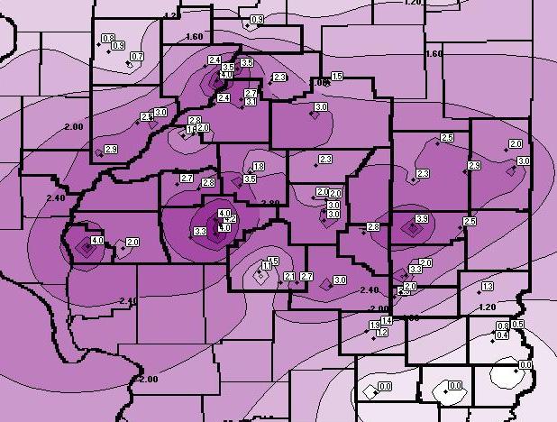
Once the atmosphere moistened sufficiently, snow finally began to reach the ground by late evening. Moderate snow then persisted through the night before tapering off and coming to an end by the early morning hours of February 25th. Widespread amounts of 2 to 4 inches were observed across much of central Illinois. Lighter amounts of 1 inch or less were reported across our far northern communities from Galesburg to Henry...as well as south of I-70, where much of the precipitation fell in the form of rain rather than snow.
US Dept of Commerce
National Oceanic and Atmospheric Administration
National Weather Service
Central Illinois
1362 State Route 10
Lincoln, IL 62656
217-732-7321 (forecast recording) or 217-732-3089
Comments? Questions? Please Contact Us.

