April 8, 2020
A widespread severe weather event impacted most of central and southeast Illinois during the late afternoon and early evening of April 8th. Scattered thunderstorms with extremely large hail in excess of 2 inches in diameter (hen egg-sized) initiated across eastern Iowa into west-central Illinois near the Mississippi River between 2pm and 4pm. The storms increased in areal coverage and eventually merged into linear structures as they pushed eastward into the NWS Lincoln County Warning Area (CWA). Thanks to favorable atmospheric conditions supporting strong winds, storm outflow produced wind gusts greater than 60mph...with localized gusts in excess of 70mph. As a result, widespread wind damage was reported from near Lincoln and Springfield east-southeast to the Indiana border.
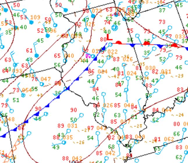
Surface analysis on the afternoon of April 8th showed an unseasonably warm airmass across central Illinois with temperatures well into the 80s. Due to deep-layer mixing, dewpoints were only in the 40s and lower 50s...making relative humidity values quite low. Low pressure was initially in place over eastern Iowa with a strong cold front trailing southwestward into Missouri. Below is the surface map from 4pm CDT April 8th...which shows the cold front advancing into the Illinois River Valley.
SURFACE WEATHER MAP 4PM CDT APRIL 8
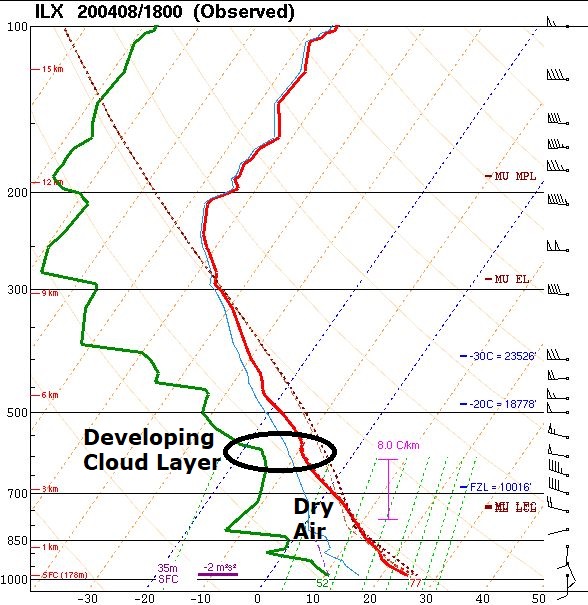
Due to the potential for severe weather, NWS Lincoln performed a special midday upper air balloon flight in order to better sample the entire depth of the atmosphere. The resulting sounding revealed modest instability with Convective Available Potential Energy (CAPE) values of just 800J/kg, but strong low-level wind shear. Winds were southerly at 10kt at the surface, then veered to the west-northwest and increased to 40kt at 3km aloft. Thanks to the strong shear and steep temperature lapse rates, the threat for vigorous, sustained updrafts and subsequent large hail became evident. Also of interest was the presence of very dry air from the surface up to about 5km. This type of sounding points to the likelihood of ample evaporative cooling as precipitation falls from the cloud...leading to enhanced wind gusts. Note how far apart the red line (temperature trace) and green line (dewpoint trace) are in lower parts of the sounding below, which visually shows the presence of dry air beneath the developing cloud layer. Despite the clear signs of large hail and damaging winds, warm air aloft was creating a strong "cap" for convective development at the time of this balloon launch.
LINCOLN UPPER AIR SOUNDING 1PM CDT APRIL 8
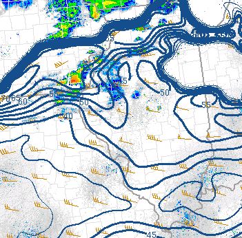
As an upper-level disturbance over the Northern Plains tracked eastward toward the Great Lakes, enough cooling occurred aloft to weaken the convective inhibition by mid to late afternoon. In addition, with strong convergence along the advancing cold front, updrafts were eventually able to break through the cap and tap into an elevated layer of instability. Once this process occurred, thunderstorms rapidly developed near the Mississippi River. Mesoanalysis from 3pm showed maximum CAPE values reaching 1000J/kg and effective shear increasing to 55-65kt immediately ahead of the low and its trailing cold front across eastern Iowa and western Illinois. The image below shows effective shear values overlaid on 3pm radar. At that time, severe thunderstorm cells had initiated over far southeast Iowa.
EFFECTIVE SHEAR 3PM CDT APRIL 8
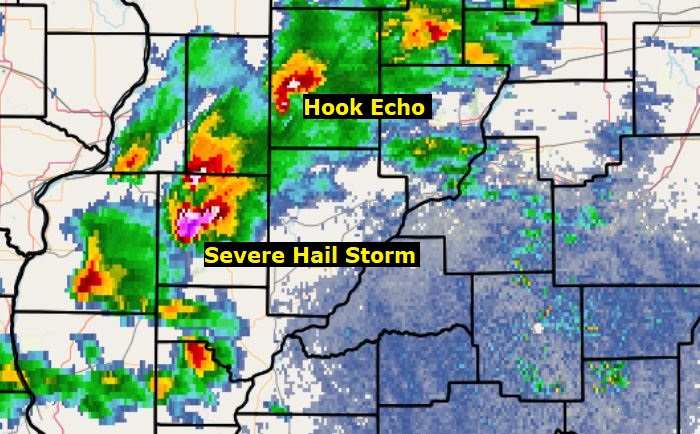
Additional supercell thunderstorms rapidly developed west of the Illinois River. The 4:02PM radar imagery below shows a severe hail-producing storm near Macomb in McDonough County, with a hook echo further northeast in Knox County.
4:02PM
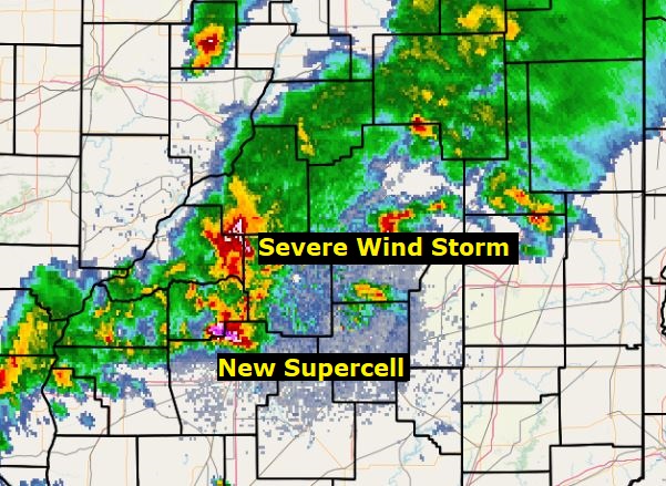
As the storms progressed eastward, numerous cell mergers and interactions occurred. By 5:10PM, the McDonough County cell was accelerating across Mason County, while a new supercell was developing further south across southeast Menard County. When the northern storm tracked across Logan County, it produced a 63mph measured wind gust at the NWS office in Lincoln. Meanwhile, the southern cell dropped 3-inch diameter (larger than baseball-sized) hail just south of Sherman in northern Sangamon County.
5:10PM
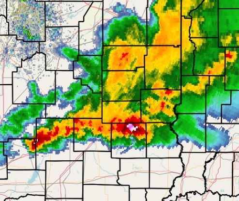
The storms continued to produce wind damage across east-central Illinois as they gradually merged into a continuous line. The 7:14pm radar picture shows an impressive line of storms producing winds of greater than 60mph, with localized enhanced winds of 70-80mph. Numerous gustnadoes developed along the outflow boundaries of these storms.
7:14PM
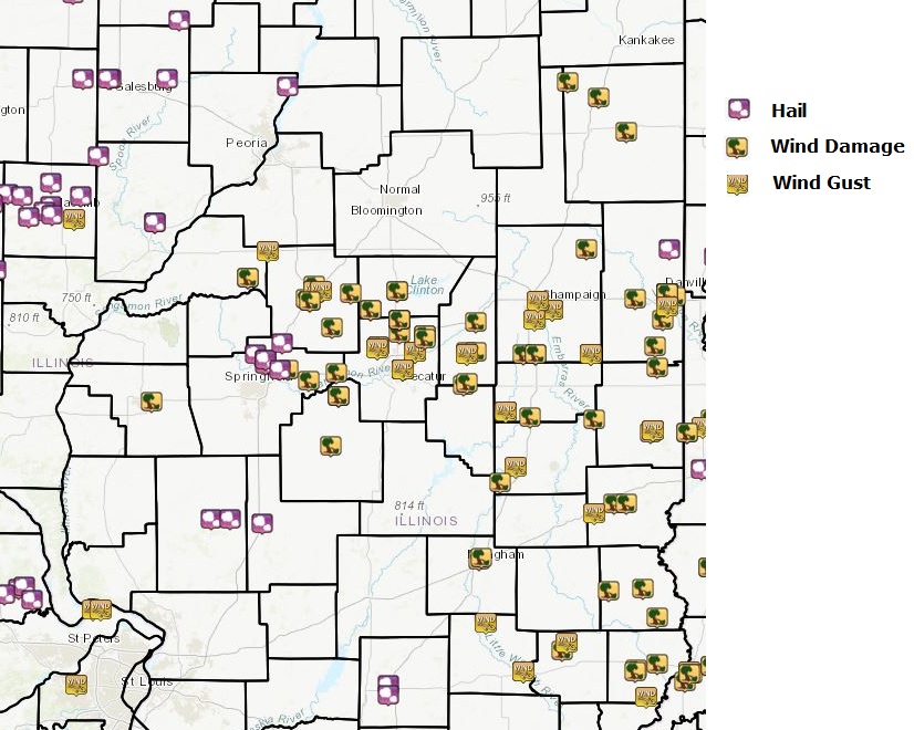
Below is a preliminary map of the severe weather reports received across central and southeast Illinois on April 8th. There may be additions and/or changes over the next couple of days as more information is uncovered. Note that most of the hail reports occurred west of the I-55 corridor when the storms were more discrete (cellular) in nature, whereas the bulk of the wind reports were focused further east and south when the storms became primarily linear.
Picture of mammatus clouds near Nokomis after the storms departed.