April 9, 2015
A broken line of strong to severe thunderstorms developed across central Illinois during the late afternoon and evening of April 9th. Due to unseasonably high dewpoints in the lower to middle 60s and increasingly strong low-level wind shear, some of the storms began to rotate as they tracked across the area. Two tornadoes touched down in central Illinois: however, they were both weak and short-lived.
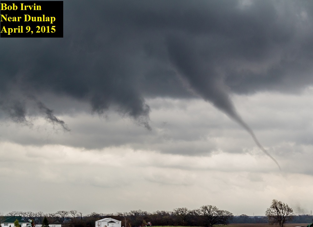
Surface analysis on the morning of April 9th showed a 999mb low pressure just north of Kansas City, with a warm frontal boundary extending eastward into north-central Illinois. Thanks to an upper-level disturbance well ahead of the approaching low, showers and thunderstorms were ongoing east of the I-55 corridor. These storms generally remained below severe limits, but dropped between 1 and 1.50 inches of rain in Danville, causing some urban flash flooding. As the upper wave departed, the showers and thunderstorms became more isolated in nature from mid-morning through mid-afternoon. Strong southerly winds and a few breaks in the overcast allowed temperatures to climb well into the 70s by afternoon, resulting in Convective Available Potential Energy (CAPE) values in the 1500 to 2500J/kg range. As mid-level capping from the early morning convection gradually weakened, isolated thunderstorm cells began to develop well ahead of the low and its trailing cold front by mid-afternoon. One of those cells was able to tap into the strengthening low-level wind shear to produce a brief tornado near Dunlap in Peoria County. The tornado touched down in an open field and caused no damage before quickly lifting. Below is a picture of the tornado submitted by one of our SWOP members.
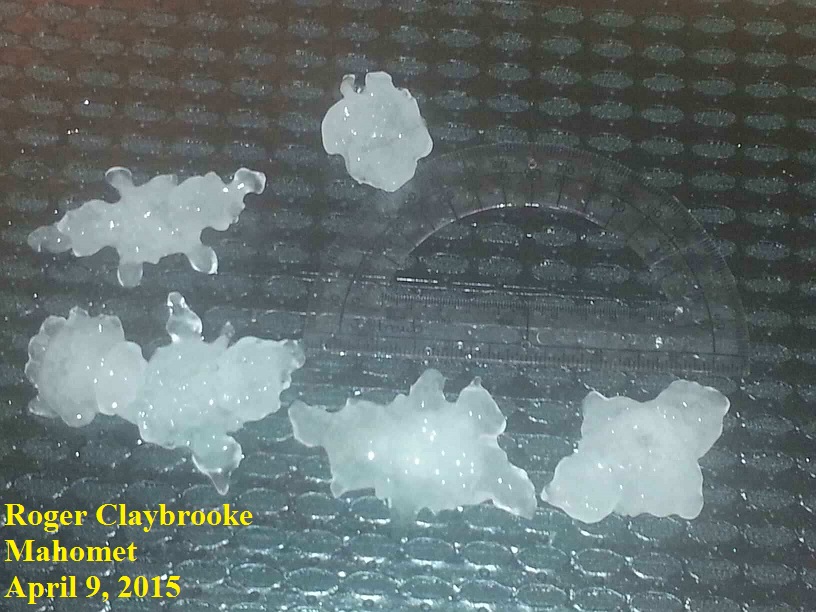
Later in the afternoon, several thunderstorm cells initiated along an advancing cold front across southern Iowa into Missouri. These cells quickly began rotating, indicating that they had the potential to produce tornadoes and would likely be long-lived. As a result, a Tornado Watch was issued for much of central Illinois. The storms crossed the Mississippi River into the Illinois River Valley between 5 and 7pm, producing numerous reports of hail as large as golfballs. The broken line of convection progressed to the I-55 corridor between 6 and 8 pm before pushing into east-central Illinois later in the evening. One of the storms produced a brief tornado just south of Tovey in Christian County: however, it caused no damage before quickly dissipating. The individual cells eventually congealed into a solid line from Shelbyville southward to near Salem. As this line tracked northeastward, damaging wind gusts of around 60mph knocked a few trees and numerous trees branches down across portions of Effingham and Cumberland counties. A shed was damaged in far southern Shelby County and another shed was destroyed in Neoga in Cumberland County. Further north, a separate thunderstorm cell dropped very large hail across parts of Piatt and Champaign counties. SWOP observers in Mahomet in northwest Champaign County reported hailstones as large as 3 inches in diameter. The picture below reveals the hail was actually a jagged conglomeration of individual stones frozen together. The extremely large hail was short-lived and was not accompanied by strong winds, so it did not produce any widespread damage. After that, the storms pushed into Indiana between 11pm and midnight.